Talun-Huma, Swidden Agriculture, and Rural Economy in West Java, Indonesia
Mizuno Kosuke,* Siti Sugiah Mugniesyah,** Ageng Setiawan Herianto,*** and Tsujii Hiroshi†
*水野広祐, Center for Southeast Asian Studies, Kyoto University
Corresponding author’s email: mizuno[at]cseas.kyoto-u.ac.jp
**Department of Communication and Community Development Sciences, Faculty of Human Ecology, Bogor Agricultural University, Jl. Kamper, Kampus IPB Darmaga Bogor, Indonesia
***Department of Agricultural Socio-Economics, Faculty of Agriculture, Gadjah Mada University, Jl. Flora, Bulaksumur, Yogyakarta 55281, Indonesia
†辻井 博, Professor Emeritus, Kyoto University
DOI: doi.org/10.20495/seas.2.2_351
Talun-huma is an intensified land use system for swidden agriculture in Indonesia. Talun is a productive fallow system that is meaningful from ecological, social, and economic perspectives. Although it is considered a typical practice in West Java, this study proves that the term talun was used in many places in Indonesia besides West Java during colonial times.
This study also shows that talun-huma and agroforestry practice in the surveyed village is closely linked to the socioeconomic structure of the rural society based on the data collected in 2000–1. Huma is more likely to be practiced by the lower strata owning little agricultural and forestry land. The economic development reflected in the growth of banana leaf production and income from the non-agricultural sector income has not excluded or diminished talun-huma and agroforestry practices. Sharecropping practices and agricultural labor relations among the villagers have established huma practice. The social forestry program implemented in this region also supports the continuity of huma practice. Increase in banana leaf production does not diminish the practice of huma and talun agroforestry, although banana leaf production tends to shorten the duration of the cycle. Moreover, the development of non-agricultural sectors and wet rice cultivation has had a positive impact on the existence of huma practices and the continuation of slash-and-burn practices.
Talun-huma and permanent forests with or without talun are good practices that keep the system sustainable from an economic and social point of view. Diversified farming, balanced rotation of land use, and diversity of plants, as well as the planting of leguminous land conservation trees such as kaliandra and gamal, play an important role in sustaining the system.
The introduction of banana leaf plants to the village in the 1990s has contributed significantly to the continuity of the system because the plants are a considerable source of income for villagers, both as farmers and as agricultural laborers. They can rely on the income from the hilly dry land. A problem that might, however, become serious in the near future is that banana leaf planting shortens the duration of the cycle and may render the land infertile.
Keywords: talun-huma, swidden agriculture, agroforestry, rural economy, Indonesia, West Java, sustainability, talun
Introduction
The importance of the talun system as an example of agroforestry was introduced to international academia by Otto Soemarwoto in the 1980s. He used the term talun-kebun, which he explained as a kind of shifting cultivation practiced in a man-made forest. It combined many species of perennials and annuals in multi-layered and single-layered arrangements, forming an often-dense canopy of vegetation that protects against soil erosion and leaching. Structurally, the talun-kebun is divided into two parts: the talun, or selected productive fallow “forest,” consisting of the overhead cover of essentially long-term perennials, and the kebun, comprising various areas of cleared ground within the talun planted with annual crops such as vegetables, fruits, and cereal crops, rather than dry rice, spices and so on, destined mainly for market sale. Upon harvest, the kebun is allowed to grow perennials and returned to the talun within five to eight years.
The talun is planted with a mixture of many species of trees but may be dominated by one species, typically bamboo, in which case it is named after this species, so talun awi is bamboo talun. The talun has four important functions: (i) subsistence production, (ii) commercial production, (iii) gene banking, and (iv) soil conservation and sustained productivity (Otto Soemarwoto et al. 1985, 49–50).
This talun-kebun is clearly different from conventional notions of swidden agriculture. For example, according to Sasaki, in the swidden agriculture of Southeast Asia, a plot is cultivated for less than three years, five at most, then left fallow. This agriculture can supply food for a population density of around 25–30 persons/km2. The duration of the period in which the land is left fallow is 8–15 years before people slash-and-burn the plot again (Sasaki 1970, 86–122).
Often, however, shifting cultivation practices tend to shorten the fallow period, resulting in a degraded system with time or as the population density increases. People are then likely to leave the degraded land. Alternatively, land rehabilitation takes place when farmers invest in improved land management and care for the environment—provided they have reasonably secure land or tree tenure and if it is profitable compared with other investment options. Alternative land use intensification pathways that do not first involve severe land degradation do exist in the form of complex agroforestries that have been developed by indigenous communities (Sanchez et al. 2005, 6–7). Some such cases have been studied, including cacao planting in swidden agriculture land (Duguma et al. 2001) and swidden fallow agroforestry among the Bora Indians of Amazon, which is adaptable to varying environmental and economic situations (Padoch and de Jong 1987), but such studies still remain small in number.
The talun system illustrates a case of alternative land use intensification for shifting cultivation. Otto Soemarwoto distinguished between two types of talun—permanent talun and talun-kebun. In the permanent talun, trees are typically densely spaced and the canopies are closed. Hence, little light penetrates the canopies and only a few shade-tolerant species, such as the taro-like Xanthosoma, are planted. These crop species and weeds form the undergrowth of the talun. In other talun, the trees are sparsely planted so that more light can reach the floor. In such cases, many annuals are grown (e.g., corn, cassava, and sweet potato). Many weeds are also found in the talun. Such talun are usually called kebun campuran, which means “mixed garden,” denoting a mixture of annuals and perennials. In the permanent talun, the practice of slash-and-burn is discontinued.
In the talun-kebun, a clearing is deliberately made in the talun at the beginning of the rainy season, either by clear cutting (e.g., bamboo), or by selective cutting (e.g., Jeungjing, Albizzia chinensis) and heavy pruning of the remaining perennial trees. The trunks and large branches are taken out of the clearing and sold as construction materials and fuelwood, and twigs and leaves are spread out to dry in the sun, then piled up and burned. The ash is collected and mixed with cattle dung brought in from the villages.
A mixture of annual crops is grown in the clearing, which is then called kebun, literally “garden.” The major crops grown are beans at Ciwidey and Soreang in Southwest Bandung, and tobacco and onion at Paseh in Southeast Bandung in West Java. The planting of the different crops is not done all at once but in succession. Harvesting is also carried out over an extended period. By the time the last crops are harvested, which occurs about 18 months after the clearing, the trees would have resprouted. People then clear another area and repeat the process. Consequently, the kebun moves around inside the talun with a cycle of about six to eight years. Essentially it is a form of shifting cultivation (Otto Soemarwoto and Idjah Soemarwoto 1984, 274–276).
We understand that the land of shifting cultivation, here called kebun, is mainly planted with annuals after slash-and-burn, and then planted with perennials after the harvest of annuals, at which stage it is sometimes called kebun campuran, after which it enters the stage of talun, a productive fallow stage. Another land use after slash-and-burn and subsequent planting of annuals and perennials is to discontinue the slash-and-burn process and use the land as a permanent talun, or kebun campuran with no more slash-and-burn.
Talun and talun kebun have been studied substantially, especially from the ecological perspective, and intensively in the case of bamboo talun in West Java. Species diversity has been a typical characteristic. Johan Iskandar et al.’s study showed that 112 species were planted by the local people at a village in Soreang sub-district in Bandung district (Johan Iskandar et al. 1981, quoted by Herri Y. Hadikusumah 2005, 269–283). Herri Y. Hadikusumah (2005, 256–259) demonstrated the variety of plants in the layers that form the talun. Linda Christanty et al. (1996a) focused on biomass accumulation, and Linda Christanty et al. (1996b) and Mailly et al. (1996) discussed the biochemical role of the bamboo. Parikesit et al. (2004) discussed kebon tatangkalan, a form of permanent talun, as a habitat for various organisms living there, including birds and insects, and the decreasing area of such habitat because of growing demand for agricultural, industrial, and settlement lands.
The present study attempts to show a different talun system in detail—the talun-huma, which is associated with dry rice planting as annuals after slash-and-burn, rather than vegetables as the main planting, and mixed perennials rather than bamboo at the productive fallow stage. The study aims to enrich understanding of the talun agroforestry system as an alternative land use intensification. It will shed light on the economic contribution that is essential for the household economy and for the sustainability of the system from a quantitative perspective (such as amount of income), as well as qualitative viewpoint (such as stratification of rural society and the land tenure system). This study also intends to describe the directions taken by land use intensification, that is, with or without slash-and-burn, and with or without talun, and to analyze these directions. In this way, the impact of economic development on the talun-huma and agroforestry system will be studied from the perspectives of growth of the agricultural and the non-agricultural sectors. The talun-huma and agroforestry here means talun-huma, related practices with or without talun (huma), and permanent forest with or without talun. These descriptions and analyses will be based on data and information collected by fieldwork at a village in Cianjur district (Kabupaten Cianjur), West Java. This study also examines the validity of the concept of talun outside West Java as a preliminary study.
Section I discusses previous studies of the talun system and, using a variety of sources, areas in which the system prevails. We proceed to describe the location where field study was conducted in the second section and elaborate upon the talun-huma and agroforestry system in the third. The direction of land use intensification, as well as the roles of the talun-huma and agroforestry system, especially in terms of economic contributions, is examined in Section IV, and Section V concludes this study.
The field survey was conducted over 10 years between 1998 and 2007. In total, 60 households were surveyed, using household survey questionnaires. The data used in this paper is based mainly on the study in 2000 and 2001.1)
I Talun and Agroforestry Systems in Indonesia
I-1 Talun in Indonesia
According to Otto Soemarwoto (1983, 222), land use such as the home garden (pekarangan) —but with no houses on the land—is found in West Java and other areas with some variations. This land use is called talun in West Java. He also stated that the talun-kebun is typical of West Java, especially in the Priangan region (Otto Soemarwoto et al. 1985, 48). Such a view is shared by many researchers (Herri Y. Hadikusumah 2005, 269; Johan Iskandar 2009, 150), including Terra’s study of 1953.
Terra mentioned the talun in the context of a mixed garden study, explaining the kebun besides the home garden (pekarangan):
The kebun is situated near or around the villages, sometimes at some distance. The kebun is sometimes planted with fruit trees, or coconut palms, sugar palms, banana, tea, coffee, or bamboo only. They are distinguished from plantings, mostly in clumps, of fruits trees etc. on former ladang (fields in use for shifting cultivation). Instead of kebun (Malay), in Java the term used is often talun (Sunda) and outside of Java dusun (Ambon, Ceram), mamar (Timor), porlak (Batak), peureuh (Achin), krakal (Purworedjo, Java). (Terra 1953, 163–164)
Data on customary law during the colonial time in Indonesia show, however, that the term talun was not limited to West Java. Research carried out on customary law in North Sumatra (Adatrechtbundel VI 1911, 124) indicate that taloen meant a cleared plot where people grew sugar palm for sapping, sirih, and other crops in the Gajo, Alas, and Batak areas. The land was wasteland, but trails left by labor for cultivation and the like show that people’s rights had arisen. In Minahasa, talun means forest, and mengatalun means to become forest, or to revert to forest where people do not cultivate regularly (Adatrechtbundel IX 1914, 132). The Malay people living in Sumatra use the term beloekar taloen to signify young forestland where trails of former exploitation are still apparent, and beloekar toea-taloen tabang for old forests that used to be exploited and where trails of former exploitation are still more or less apparent (Adatrechtbundel X 1915, 221). In East Java, talon, talun, or talunan means abandoned garden, abandoned cultivated land, or unirrigated cultivated land in the mountainous area. These are planted with plants other than rice and are not located at the center of the village (Adatrechtbundels XIV 1917, 230). In West Java, taloen is newly cleaned tegal (cultivated dry field) (Adatrechtbundel VIII 1914, 198), while in Borneo, Tidoengsch, and Tinggalan, the term means forest or light forest (Adatrechtbundels XIII 1917, 55). In Central Java, cleared land where dry rice is planted because water cannot be brought in and which is abandoned after one or two plantings is called taloen or pengalang-alangan. Pengalang-alangan means land where alang-alang (Imperata cylindrica) is allowed to spread on purpose, with the weeds belonging to the exploiter, and taloen means land formerly planted with dry rice and now covered by alang-alang and other weeds. Anyone may remove the weeds and plant dry rice again (Adatrechtbundels XIV 1917, 40).2)
As we can see, the term talun is used in many areas in Indonesia such as West, Central and East Java, North Sumatra, Minahasa, Malay people’s areas in Sumatra, and Borneo. In general, talun is non-irrigated land located in a hilly or mountainous area. It signifies forest that was once cultivated then abandoned. In many cases, it is thought of as fallowed area. In Central Java, the taloen belongs to the person who first cleared the land and who would cultivate the land again.
The term talun even became the name of villages, mountains, and sub-districts. A dictionary of geography published in 1869 mentioned the name of Taloen in six villages (dorps) in Central and East Java.3) Taloen was also the name of a mountain (berg) in the residency (residentie) Rembang, division (afdeeling) Toeban (Veth 1869, 862). A directory of local administrative bodies published in 1931 mentioned the name of Taloen in two sub-districts (onderdistrict) in Central and East Java, as well as 10 villages (desa) in Java island. Of these, five were found in East Java, two in Central Java, two in West Java, and one in the gewest (province) of Soerakarta (Schoel 1931, 373).4) A dictionary of geography published in 1917 cited 10 locations named Taloen in Java island, and 1 location in Borneo as Taloenliaoe (Dumont 1917, 565–566).5)
Thus we can say that the term talun, taloen, or talon has been used since at least colonial times in many parts of Indonesia with relation to forest, or forest once cultivated then fallowed or abandoned. The term taloen was also used as the name of villages, sub-districts, or mountains in many places in Java island, especially in Central and East Java, and partly in Borneo. Why is talun thought to be characteristic of West Java? One possible answer is that other areas now have different terms for a similar system of agroforestry.
I-2 Agroforestry in Indonesia
Adatrechtbundels show different words that mean forest similar to fallowed land. In the Batak area in North Sumatra, rimba oma, rimba aroeng, and rimba haoe mean secondary forest that has been exploited then fallowed. Rimba oma is forest that has been fallowed for one–six years, and rimba aroeng for six–nine years. Oma is a kind of grass, aroeng or tolong is a kind of reed, and haoe is grown trees (Adatrechtbundels XXVII 1928, 176–177).
Many recent ecological studies on agroforestry similar to talun have been conducted. The dusun system in Central Maluku has been discussed by Monk et al. (1997, 718–737) and by Kaya et al. (2002, 232–233). Sardjono introduced the lembo system in East Kalimantan (Sardjono 1988, quoted in Herri Y. Hadikusumah 2005, 262–268) while Johan Iskandar has studied the kaliwo or kalego system in West Sumba similar to kebun campuran, and the kaleka system in Bangka Belitung, which is multi-layered forest on a former slash-and-burn location. The planting of lada/sahang (Piper nigrum) and rubber (Hevea brasiliensis) is booming because of their good price in the markets. The pelak system in Kerinci, Jambi consists of the planting of annuals such as vegetables for two years after slash-and-burn, followed by the planting and harvest of dry rice. Perennials such as coffee are planted alongside the annuals, and after the harvesting of perennials, people will chose either to slash-and-burn and then to plant dry rice again, or to keep the perennials (Johan Iskandar 2009, 153–161). Rubber agroforestry called “jungle rubber” in South Sumatra was introduced by Gouyon et al. (1993).6) Damar forest produced after slash-and-burn is also man-made forest in Lampung, Sumatra (Torquebiau 1984).7)
We see that in Indonesia, besides the talun, there are many agroforestry systems that involve slash-and-burn, followed by fallowing and the planting of perennials during the fallow. Cyclical systems that slash, cut, and burn the old perennials are found; on the other hand, continual plantings of the perennials with no more slash-and-burning are more common, and sometimes good prices support the spreading of some kinds of perennial planting. These agroforestries always retain the characteristics of diversified farming with a multi-layered canopy as a man-made forest during the productive fallow, or continual planting of perennials with no more slash-and-burn.
However, the question why the term talun, taloen, or talon, once used in many places both in Java and the outer Java islands as the term for man-made forest, fell out of use in the area outside of West Java, remains unanswered. Possible answers might be: i) land use of talun decreased or even disappeared outside West Java because of population and production growth, or was transformed into other forms such as kebun campuran; ii) people forgot the meaning of the term and do not use it any more;8) iii) local variations in government policy such as the prohibition of slash-and-burn since the colonial time was what differentiated West Java from other areas; and iv) researchers have not found talun land use outside West Java. This paper does not address this question; nonetheless a detailed description and analysis of the sustainability of another form of talun is quite important for the investigation of these issues.
II Kemang Village: A General Picture and Highland Farming
II-1 Kemang Village: A General Picture and Agriculture
Kemang village, the research site, belongs to Bojongpicung sub-district of the district of Cianjur. It is located in the hilly and mountainous Priangan highlands, about 7 km from the center of the sub-district, with a mountainous pass between the village and the center.
The village is surrounded by mountains that constitute a natural barrier, as such migration into the village is low. The population density of 174 persons/km2 in the village (including the land controlled by the National Forestry Corporation, Perum Perhutani) or 297 persons/km2 (excluding the area controlled by the National Forestry Corporation) in 2001 is relatively small compared to the average population density of 1,009 persons/km2 in West Java in 2000 (BPS 2001). The population in 2001 was 4,384, with a village area of 2,518.63 ha. Of this, forests controlled by the National Forestry Corporation cover 1,040.6 ha, comprising 135 ha of protected forest (hutan lindung)9) and 905 ha of production forest (hutan produksi).10) The land controlled by the National Forestry Corporation has been designated as forest area (kawasan hutan) by the central government. The farmland located outside the kawasan hutan is privately owned by the locals, with 878.6 ha of it used as pasir, dry land where upland farming and perennial tree planting are combined. Rice fields are found in the low area of the village and occupy a relatively small area, accounting for just 83 ha (Desa Kemang 2001). Pasir land is not counted as forest by the government; however, the landscape at the stage of talun, full of perennial trees, is quite similar to the forest.
In this pasir land, dry rice, annual crops such as vegetables and tubers, and perennial trees are planted as a form of shifting cultivation, and talun forms a multi-layered canopy of vegetation, particularly perennial trees, as the final stage of the land use cycle. These land use and cultivation methods are described in detail in the following section.
In the area controlled by the National Forestry Corporation, social forestry programs have been implemented since the 1990s, enabling the local people to take part in the maintenance and cultivation of the area. Under the program, they first carry out slash-and-burn, then cultivate the land with dry rice and annual crops. At the same time, they also plant trees designated by the company, usually teak (Tectona grandis), and maintain these alongside their own plantings of other perennial trees such as fruit trees like nangka (Artocarpus integra). All the harvests from the land are meant for the people, except that of the trees belonging to the company. In 1998, the National Forestry Corporation integrated the “Forest Village Society Program” (Program Masyarakat Desa Hutan, PMDH) and the “Social Forestry Program” (Perhutanan Sosial) into the “Integrated Forest Village Society Program” (Program Masyarakat Desa Hutan Terpadu, PMDHT). Kemang Village was chosen as a model village for PMDHT (Inoue et al. 2001, 73).
Because talun located on privately-owned pasir land is quite similar to forest in its landscape, we can find forestry both on the land controlled by the National Forestry Corporation and on the land owned by the people. However, according to the village head, the term hutan (forest) is only applied to the forest controlled by the National Forestry Corporation, so hutan is similar to kawasan hutan. Other forest on the land owned by the people is called pasir, or talun, and not hutan.
According to the villagers, the National Forestry Corporation boundary was established during the colonial era. National Forestry Corporation land was not open to ownership by individuals; but people privately owned pasir in non-National Forestry Corporation land. Much of National Forestry land was managed by the people as part of a social forestry program scheme. However, since leaf banana planting has prevailed, especially since around 2004, people have been planting these crops even though land is not allocated to them in the scheme of the social forestry program.
In any event, pasir, the privately-owned dry farmland planted with annual crops and perennial trees, the National Forestry Corporation’s land on the slopes of the mountains and hills, and the wet rice fields located in the lowland in the village are the major areas of cultivation for the people in the village surveyed. Many of the plants in the uplands and the National Forestry Corporation area are subsistence-oriented, but some plants are highly commercialized. The most important plant in the National Forestry Corporation’s area is teak; in the private upland areas, it is banana plants (Musa sp.), which have been increasingly popular since the second half of the 1990s, sugar palm (Aren, Arenga pinnata), chili plants (Cabe, Capsicum annuum), and dry rice (Pare huma, Oryza sativa). Recently the planting of albizzia has increased, especially since around 2006.
Among 60 respondent households, 44 households have their own rice field, whose average area is 0.14 ha. In addition, 46 households have dry land (pasir), measuring on average 0.91 ha. Many of the farmers who own dry land also have their own wet rice fields. Table 1 shows the number of households according to dry land and wet rice fields owned. Some households possess more than 3 ha of dry land; these households tend to also own wet rice fields. In contrast, 10 households own neither dry land nor wet rice fields.
Of the households surveyed, 29 participated in the social forestry program, farming 0.25–1.25 ha of National Forestry Corporation land. The average area of the land farmed under the program was 0.43 ha. Households participating in the social forestry program are mainly those that own small areas of farmland or none at all. Of the 10 households without their own land, 9 joined the social forestry program. However, there are some households that own relatively large areas of dry land yet still join the social forestry program. The number of households in the parentheses in Table 1 is based on the area of farmed land both for wet rice fields and dry land, including social forestry program land. This table shows that only one household does not farm any land. Besides the social forestry program, there are arrangements of sharecropping, land lease, and mortgage contracts. So the farmed land average is somewhat larger than that of owned land, especially for dry land. Average dry land farmed, which includes social forestry program land, is 1.21 ha, and 0.20 ha for wet rice fields.
Apart from the cultivation of wet rice fields and dry land, there are non-agricultural activities including furniture manufacturing, rice milling, timber trading, grocery stores, and trading banana leaves. Also important is the supply of migrant workers, especially international migrants who work in Saudi Arabia.
The village consists of 22 hamlets forming 3 sub-villages (dusun)—dusun I, dusun II, and dusun III, which have 7, 5, and 10 hamlets respectively. The village lies at an altitude of 400–800 m above sea level, and the topography ranges from gently sloping to steep hilly terrain. Access to the nearest town is not easy. The road providing access to the town was built in the 1990s. Before that, people had to walk there.
II-2 Talun-Huma in Kemang Village
The slopes of the mountains and hills are used for upland agriculture and forestry. The land use system is quite complicated, but there are typical cases of land use.
The following is the explanation of each stage of the talun-huma. The first stage, rarahan, takes nearly three months, from July to September. The work consists of nyacar (tree slashing), ngahuru (the first burning of slashed trees), ngaduruk (the second burning of remains from the first burning process), ngadampas (clearing land from the remains of burning), ngababantal (making terraces), and nyara (collecting the remains from the ngadampas). In July, farmers usually start nyacar by cutting trees, bamboo, shrubs, and other horticultural trees selectively. They cut the very young and old aren trees that have already been tapped for a long time, say 20 years, bamboo, awi ageung (Gigantochloa verticillata) and awi tali (Gigantochloa apus), leguminous trees such as kaliandra (Calliandra calothyrsus), shrubs such as sadagori (Sida retusa), and old banana plants (Musa paradisiaca). Then they leave the slash to dry. For 0.25 ha of dry land, the nyacar takes 4–5 days, and the drying usually takes about 15–20 days, sometimes even one month depending on sunlight, temperature, and the kind of slash.
The next activity is ngahuru, where farmers gather the small dried branches, leaves, and litter in piles and burn them. This activity is usually conducted in the period from the second week until the end of August. Ngahuru usually takes one–two days and burning continues until the piles become ash. Then occurs ngaduruk, whereby farmers pile up the remaining slash that had not burned well during ngahuru and reburn it until the piles are reduced to ash. Ngaduruk is usually conducted one or two days after ngahuru and can last anything between two days and two weeks, as farmers have to collect the remaining slash spread over the plots.
Next comes ngababantal—making babantal (terraces) in the sloping plot. Farmers lay trunks, large branches, and bamboo as babantal to prevent erosion. The distance between each babantal is usually 3 m. Ngababantal usually takes more time, about 12 days. Farmers feel this is the most difficult work in the talun-huma as it involves making terraces. This process is called ngais pasir, meaning to carry the pasir (dry farming land) as if it were a baby wrapped in the traditional women’s sarong (sinjang pangais)—a phrase that expresses love and care for the pasir.
The next activity is called ngadampas, in which farmers clean the remaining vegetation from the plot by chopping the roots using a short machete (parang). After ngadampas, the work of nyara follows. This consists of collecting the remains from the ngadampas and the ash, and putting them into the babantal, which in turn become seedbeds. The nyara practice is closely related to boosting soil fertility. Most of the farmers in Kemang village do not use manure to fertilize the seedbeds as not many raise goats or sheep and the plots are located far from their yards at home.
Some trees remain in the field during the rarahan period, usually the wood trees, bamboo, fruit trees such as mango (Manggah, Mangifera indica), rambutan (Nephelium lappaceum), petai (Peuteuy, Parkia speciosa), jengkol (Pithecolobium lobatum), jackfruit (Artocarpus heterophyllus), aren, and leguminous trees such as kaliandra, gamal (Gliricidia sepium), and dadap negeri (Erythrina sp.) These leguminous trees have the role of conserving the land by fixing nitrogen.
During the rarahan stage, the farmers start planting two kinds of young banana plants: cau buah (fruit bananas) and cau manggala or cau daun (leaf bananas), before the first rain when dibbling for huma paddy starts. As the day of the first rains approach, the seeds of horticulture commodities such as pumpkin (Waru, Hibiscus similis), cucumber (Bonteng, Cucumis melo), and watermelon (Sumangka, Citrulus vulgaris) are planted. Cucumbers and watermelon are usually planted close to the area where the slashes are burnt. Except for pumpkins, two or three seeds are put in each hole, dug close to the trunk of a tree or a tuturus (bamboo stick for beans or other climbing plants). Pumpkins are planted at the edge of the sloping part of the plot (sisi gawir). Maize (Jagung, Zea mays) and huma paddy are planted on the same day. Huma rice seeds are planted in the open area after dibbling using a simple traditional tool called aseuk, while cabe rawit (small chili, Capsicum frutescens) seeds are usually sowed in the area close to the babantal.
As the huma rice starts growing (usually in October), the period called huma starts. The name of this period/stage comes from huma, originally meaning dry rice growing. Pare huma is rice harvested from dry rice growing in Sundanese. This huma has become the name of a land use stage for the villagers, although, in addition to dry rice, many kinds of horticultural crops and woody plants are planted during the period. The term rarahan originated from the activities of slash-and-burn, but it has also come to signify a stage of land use. It can be seen that despite the varied origins of the names of the stages, people utilize these terms because of the interlinked connotations.
The huma stage lasts for six months. The duration of the huma and rarahan stages are quite uniform. Farmers developed the huma stage as a strategy to meet their consumption demand, especially for food crops in the form of cereals and vegetables. Annuals of horticultural crops, particularly vegetables such as long beans (Kacang panjang, Vigna sinensis), basils (Selasi, Ocimum basilicum), eggplants (Terong, Solanum sp.), big cucumbers locally called herbis or ketimun suri, chilies (Capsicum sp.), and maize are harvested during the huma stage before the huma paddy is harvested in February and March. At this stage, farmers usually start to plant young woody plants such as jeungjing or albizzia (Albizia falcataria) and pepper (Marica, Piper nigrum), depending on the size of land. Fig. 1 shows the kinds of plants used for each stage of land use and the area planted for each plant per stage of land use (total surveyed upland used by the 60 surveyed households is 30.65 ha).
Fig. 1 Area Planted with Useful Plants by Stage of Upland Farming (2001)
Sources: Field survey conducted by authors.
Note: For our plot-based survey, respondents were asked the kinds of plants found at the plots, and the percentage of land occupied by each plant. With this information, we calculated the area planted with trees/plants. Palawija means secondary crops such as maize, soybean, or the like.
After the huma rice is harvested, the next stage is called jami, with a duration cycle of about 1.5–2 years. At this stage, the horticultural crops are continuously harvested, especially duruka (Terubuk, Saccharum edule), the tubers such as cassava (Sampeu, Manihot utilissima) and sweet potatoes (Huwi Boled, Ipomoea batatas), and others such as ginger (Jahe, Zingiber officinale) and papaya (Gedang, Carica papaya). At the end of the first year, around March or April, the farmers start to harvest the fruit bananas as well as leaf bananas. In other words, the huma stage reflects the farmers’ strategy for obtaining cereal crops and vegetable foods, while the jami stage reflects their strategy to satisfy vegetable and fruit consumption needs and the necessity to generate cash income, from banana fruit and leaf as well as from fruit trees, among which mangoes, jengkol, and peuteuy are noteworthy. At the rarahan, huma, and jami stages, the majors are annual plants, although many perennial trees are also to be found because at the rarahan stage, many tall trees are left untouched during slash-and-burning, and during the huma stage, people start to plant woody plants.
The next stage is reuma ngora, which lasts for one–three years. In this stage the land is usually dominated by young albizzias and other wood trees as well as leaf bananas and fruit trees. Annual crops are not common in this stage. The intensity of maintenance and cultivation work is lower compared with jami. Farmers continue to harvest the banana leaves and other fruits at this stage, and at the end of the period, the albizzia trees are harvested, except when farmers decide to continue to the next stage, reuma kolot. Hence, this stage is used to meet the needs for albizzia woods, usually for repairing houses and as fuelwood, as well as for obtaining cash income. Fig. 1 shows the importance of woody trees during the reuma ngora and reuma kolot stages. Bamboos are also harvested, especially for repairing houses and making hedges for the paddy field, and so on.
The duration of the reuma kolot is usually three–seven years or more. The land is less cultivated than at the stage of reuma ngora. Wood trees are dominant in this stage. Some farmers cut albizzia to earn cash by selling it; others do not cut albizzia as they prefer to harvest teak or other wood trees. Aren, teakwood, mahogany (Swietenia sp.), bamboos, and other trees are also scattered throughout the plot. Seasonal fruits such as mango, pisitan (Lansium domesticum), rambutan, jengkol, and peuteuy are harvested every year. As a consequence of the growth of woody trees, the leaf bananas gradually become smaller. Farmers usually harvest albizzia trees at the end of this stage.
People sometimes prefer to use land as kebun campuran after it has been used as jami. With this type of land use, the multi-layer of perennial trees consists of woody trees such as albizzia, and bamboo. Fruits trees such as rambutan, nangka, pineapples (Nanas, Ananas comosus) are planted, and annual plants and root plants are mixed. Aren is an important tree in the research area; people tap the sap (nira) from the aren palm and produce palm sugar from the sap. This is a productive use of the land, and it lasts for quite a long time, sometimes 10 years or more. Banana plants are often planted for both their fruit and their leaves during this period.
Talun can be started after the kebun campuran period or after the reuma kolot period. It can be categorized into three types: i) fruit trees, aren, and other natural secondary vegetation, ii) fruit trees and other natural secondary vegetation, iii) aren and other natural secondary vegetation (Inoue et al. 2001, 72). Kaliandra is an integral tree in all three categories. People do not cultivate the land but make use of it to obtain products for both subsistence and commercial use. In any case, the intensity of usage is far lower than during the period of kebun campuran or reuma kolot.
The talun-huma described above is quite different from the talun-kebun that has been analyzed by many authors. Firstly, in the talun-huma, the planting of huma paddy is quite important, whereas in the talun-kebun, almost no planting of huma paddy is found. In many cases of talun-kebun, bamboo is very important for sustaining the system, whereas in the talun-huma, bamboo has a somewhat minor role. Mixtures of perennial trees are common. The diversity of the plants and the planting of leguminous trees such as kaliandra and gamal play an important role in sustaining the system.
Planting the huma paddy with dibbling and the existence of the following stages of jami and reuma are somewhat similar to the perladangan (shifting cultivation) system practices in the Baduy area, Banten, adjacent to West Java. There, the practice of slash-and-burn followed by huma rice is quite similar to the practice found at our research site. Kebun campuran practice is also found at Baduy, but there is no talun forest. Usually the duration of reuma is four years, and in some cases, old secondary forest is found (Johan Iskandar 1992, 31–38, 74–111). However, there appears to be no particular term for this old secondary forest. In contrast, the talun-huma at our research site has a more developed system of reuma ngora, reuma kolot, and talun that usually takes more time during these stages.
With regard to social forestry programs, villagers report that people have been allowed to slash-and-burn since far before the introduction of the Forest Village Society Program (PMDH) at the National Forest Corporation land. The process of land use under the social forestry program is somewhat similar to the talun-huma, at least until the stage of jami, although people are required to plant teak from an early stage and maintain the land until the teak trees grow. Teak is sometimes substituted with mahogany and so on.11)
II-3 Variation of Land Use Stage Cycles
The above-described sequential pattern of stages is a typical case. In reality, many variations of stage cycles are found because there are many options for the farmers.
One option is the reuma ngora/reuma kolot and kebun campuran alternative. Talun is a long period with low productivity, thus some people are not keen on using this cycle. Huma is an important period for producing dry rice; however, some people are not interested in using the land as huma, preferring to plant many banana plants or have more wet rice. Yet others prefer not to use the land as reuma ngora/reuma kolot or kebun campuran. They use the land as talun for a long time, with no intention to slash-and-burn. Some people repeat huma planting every three years without entering the stage of reuma ngora, a strategy especially common among people who have recently obtained their land, or who have just started the social forestry program.
Once farmers have decided on the huma stage, they should go through rarahan, and after the huma, plant secondary crops and perennials at the jami stage, especially during rainy season. So this sequence constitutes one set that cannot be split. Reuma ngora (“young” reuma) and reuma kolot (“old” reuma) form another set.
From these observations, and also from discussions concerning permanent forest and cyclical use with slash-and-burn, we have determined five types of land use sequence.
The first is the rotating sequence from rarahan/huma/jami to the productive fallow of reuma ngora/reuma kolot, and finally to talun, or sometimes once to kebun campuran, and finally talun. In this pattern we find huma and talun in the sequence.
The second is the cyclical sequence from rarahan/huma/jami to productive fallow such as reuma ngora/reuma kolot or kebun campuran, but no talun.
The third is the cyclical sequence among rarahan/huma/jami, but without leading to productive fallow such as reuma ngora/reuma kolot or kebun campuran. This type of land use includes plots that were recently acquired/sharecropped/allocated under the social forestry program, and slashed-and-burned, but where it is not clear yet whether the plot will proceed to the stage of reuma ngora, or be slashed-and-burned again after a fallowing interval because the cultivators are not the owners of the plots and cannot/do not answer for the land use following the jami stage, especially in the case of sharecropping.
The fourth type is permanent forest with a talun stage. The fifth is permanent forest without talun, such as reuma ngora/reuma kolot and kebun campuran, or kebun campuran, or a particular forest such as albizzia forest. In these cases, talun, reuma ngora/reuma kolot, or kebun campuran are no longer productive fallow but permanent forest. These five types are shown at Table 2.
Of the 174 plots of dry land controlled by 60 households that were surveyed, the largest number of plots had adopted the second sequence—cyclical land use with productive fallow without talun. This was used in 87 cases, or 50 percent of all cases. The second largest number of plots used the cyclical sequence with talun: 38 cases, or 21.9 percent. The number of the plots including a talun stage is 48, or 27.6 percent of all plots. In contrast, the number of plots including a huma stage is 157, or 90.2 percent of all plots. Those plots go through the process of slash-and-burn. Among the 157 plots that have a huma stage, 125 plots or 79.6 percent of the plots have productive fallowing such as reuma ngora/reuma kolot, kebun campuran, or talun. Plots of permanent forest occur in 17 cases, or 9.8 percent, and among them 10 plots, or 5.7 percent of all plots had permanent forest with talun. Talun-huma referes to the first category of the Table 2 in the narrow sence, on the other hand talun-huma and agroforestry can cover the whole practices discussed above.
III Talun-Huma in the Rural Context of Social Economy
III-1 Talun-Huma and Socioeconomic Factors
The talun-huma in Kemang village displays a range of characteristics according to the cyclical sequence pattern. The characteristics are partly geographic, partly social, and partly economic as shown at Table 2.
The huma cultivated plots are located in remote areas. In contrast, the nearer the plot, the more talun is practiced. Concerning the average duration of the cycle, greater use of the talun system correlates to longer cycles.
Table 3 shows that the percentage of plots owned by the respondents was far higher in cyclical sequences with talun and huma, and permanent forest with talun. Among the 174 plots that were managed by 60 respondents households, 105 were owned by the household surveyed, and 42 were plots allocated to farmers under the social forestry scheme, 21 were sharecropped, 5 were lease-held, and 1 case was mortgaged by the respondent households. Among 21 sharecropping practices, 12 were among family members,12) and 9 were among non-family members. So the smaller the percentage of the plots owned by the respondents, the smaller the percentage of households who use the stage of talun or other productive fallows, and the shorter the average duration of the sequence cycle. People who have joined the social forestry program or sharecropped the plot tend to practice more huma and activities relating to huma (rarahan, huma and jami).
Concerning the average plot price per hectare, plots that have a talun stage fetch relatively higher prices; plots of permanent forest are also relatively highly valued. Households that own a larger area of pasir dry farmland with perennial trees planting and wet rice fields are prone to having the talun stage, but the less of these lands a household possesses, the less the amount of productive fallow in the sequence.
III-2 Talun-Huma and Economic Activity
III-2-1 Agricultural Sector
Economic activities and employment opportunities in the agricultural sector are closely related to dry land farming. The dry land farming stages give rise to variation in these activities.
Fig. 2 shows the yearly income earned by agriculture-related waged laborers in relation to upland farming stages. The amount of income is for whole households. At the time of the jami and reuma ngora stages, farm-waged laborers are in peak demand for both dry land farming and wet rice farming.
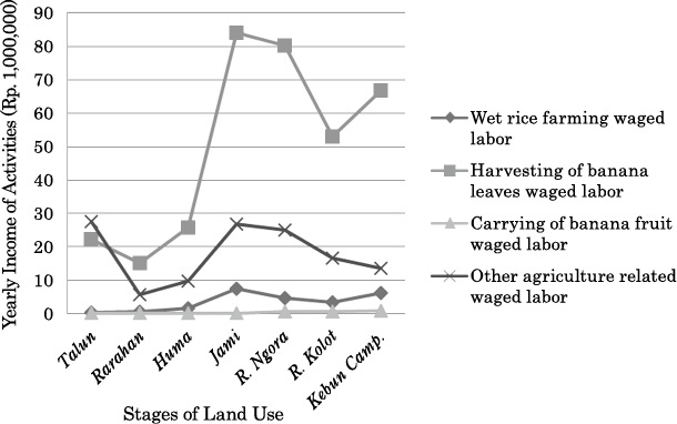
Fig. 2 Agriculture-related Wage Labor by Upland Farming Stage (2001)
Source: Field survey conducted by authors.
Income from various activities in the agricultural sector varies according to strata. Table 4 shows the yearly income composition of surveyed households according to strata. Income from wet rice farming, agricultural waged labor, palm sugar, and leaf banana production has a close relationship with the household strata. Upper strata households have a higher proportion of total household income generated by wet rice farming and leaf banana production. For lower strata households, agricultural waged labor, palm sugar production, and dry rice production generate a higher percentage of total household income.
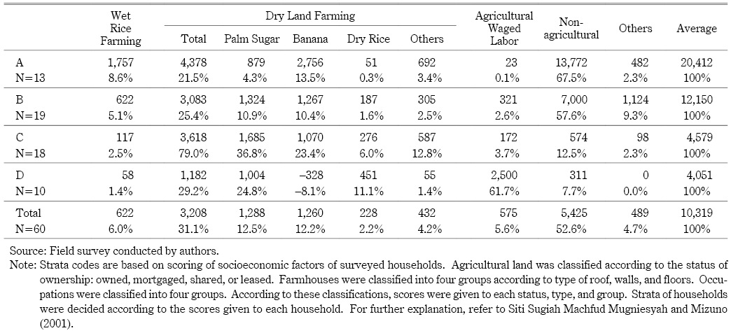
There are agricultural waged labor and sharecropping relations between the owners of pasir dry farming/wet rice farming land and agricultural waged laborers/share croppers concerning palm sugar production, leaf bananas harvesting, and huma cultivation. Products of agricultural waged labor or sharecropping are divided between the landowner and agricultural laborers/sharecroppers. The portion of products/harvests differs according to the distance from the settlements: if the location is far, the portion for the laborers or sharecroppers is two-thirds; if the plot is not far, the portion is a half (maro) (Siti Sugiah Machfud Mugniesyah et al. 1999).
Tables 2 and 3 show that the talun system is practiced by the upper strata, whereas huma is in many cases practiced by sharecroppers, or people who have joined the social forestry program. This tendency can be partly discerned in Table 4. Dry land farming is quite important for the lower strata, strata C (79.0 percent of income derived) and D (29.2 percent of income from dry land farming, and 61.7 percent from agricultural labor), especially considering that the agricultural labor undertaken by stratum D respondents is closely related with the dry land farming of strata A and B households. Although dry rice production is not so important for the income of respondents as a whole (2 percent), it cannot be neglected for stratum D respondents, for whom dry rice contributes 11 percent to their income.
Dry land farming is important for the upper strata farmers too because they manage a wider area of dry land and derive substantial income from it (21.5 percent for stratum A, and 25.4 percent for stratum B). These incomes support the sustainability of the agroforestry system constituting of talun-huma, and permanent forest with or without talun. Palm sugar and leaf banana production contribute substantially to this income. Palm sugar production has a long history, whereas leaf banana production only started in the middle of the 1990s. The flexibility of the talun-huma and agroforestry in accommodating so many kinds of plants, and the fertile soil resulting from a multi-layered, often-dense canopy of vegetation that protects against soil erosion and leaching, has enabled the planting of leaf bananas on a large scale, which is quite profitable for the respondents. It is questionable whether the widespread growth of leaf banana planting will support the talun-huma and agroforestry because of its profitability, or on the contrary, will hurt the system because of over-planting and declining fertility (Tsujii and Ageng forthcoming). Nevertheless, it is quite apparent that the talun-huma and agroforestry contributes significantly to the rural economy. Dry land cultivation, which contributes 31.1 percent of the surveyed household income, is only a part of talun-huma and agroforestry’s economic contribution. Most of the agricultural waged labor, and the banana leaf trade that are essential parts of the talun-huma and agroforestry, also contribute to the rural economy.
III-2-2 Talun-Huma and the Non-Agricultural Sector
The non-agricultural sector plays an important role in the economy. The total income amongst the surveyed households coming from the non-agricultural sector is 52.6 percent. Table 4 clearly shows that the higher the household strata, the larger the percentage of non-agricultural sector income relative to total household income.
Table 5 shows the composition of the yearly income derived from the non-agricultural sector by the surveyed households. Income derived from working in the civil service, warung (grocery) shop management, and machinery management such as chain saw rental, are clearly related to strata level, and the higher strata derive a greater percentage of income from these activities in total household income.
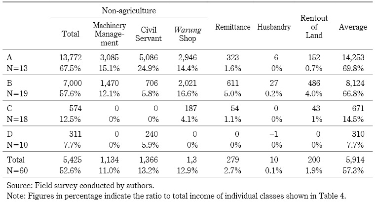
These non-agricultural sectors may contribute to sustaining the talun-huma and agroforestry because people derive substantial income from the non-agricultural sector, so they need not rely heavily on the dry land management sector, which results in longer terms of productive fallow. People may invest in the dry farming sector with the income derived from the non-agricultural sector. Alternatively, the non-agricultural sector may hurt the talun-huma and agroforestry because people do not need substantial income from the upland, and there may be too little labor to retain the cyclical sequence of land use, or maintain permanent forest in a productive way. This issue will be addressed in the following section.
IV Analysis of the Sustainability of the Talun-Huma
Many factors may have an influence on the sustainability of the talun-huma and agroforestry. From our description and analysis above, the distance of the plot from the house, duration of holding since acquisition, duration of the cycles, ownership status of the plot, area of household holding of dry land and wet rice field, and price of the plot are considered to be important for the sustainability of the talun-huma and agroforestry. It is debatable whether income from banana planting and non-agriculture will support or hurt the talun-huma and agroforestry. In order to determine whether these factors are positively related to the sustainability of the talun-huma and agroforestry, correlation between these factors and sustainability, and sequential cycles were examined and analyzed by some methodologies of multivariate statistics, using the area of total pasir/wet rice fields land owned by surveyed households, distance of the plots, income from banana production, income from non-agricultural sectors, income from wet rice farming, ownership status, and the number of household members13) in relation to the data of each plot as variants.
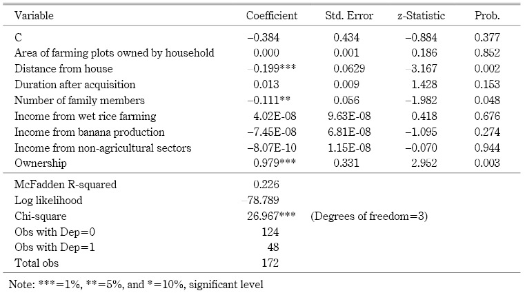
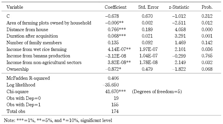
Whether the talun stage exists or not is qualitative data. This data can be analyzed with a probit model. We have assumed the following linear equation parameters:
DT=F1 (WUH, DIT, DMN, NFM, IWR, IBL, ING, OWN) (4-1)
In order to examine the influence of these factors on whether the talun stage exists or not, we have assumed the following linear equation parameters:
DT: Dummy variable of existence of talun for each plot (1: Talun in, 0: Talun out)
WUH: Area of farming plots owned by one household, which includes the wet rice farming and dry land farming (in ha)
DIT: Distance from the farmhouse surveyed to the upland farm plot (in km)
DMN: Duration of land management after acquisition by respondent (in years)
NFM: Number of family members in the household surveyed
IWR: Income from wet rice cultivation by household surveyed during 2001 (in Rupiah)
IBL: Income from banana production by household surveyed during 2001 (in Rupiah)
ING: Income from non-agricultural sector activities by household surveyed during 2001 (in Rupiah)
OWN: Ownership of plots using dummy variables (1: owned by household member, 0: not owned by household member, such as sharecropped)
From this Table 6 we can estimate that the nearer to the house, the smaller the number of family members, and whether the land is owned, the greater the likelihood of talun being practiced. Income from non-agricultural sectors, banana production, and wet rice are not statistically proved to be related to the question of whether or not talun is practiced.
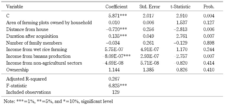
Now we examine the question of whether or not huma is practiced, or slash-and-burn is practiced, using a probit model. We have assumed the following linear equation parameters:
DH=F2(WUH, DIT, DMN, NFM, IWR, IBL, ING, OWN) (4-2)
DH: Dummy variable of existence of huma practice (1: Huma in, 0: Huma out)
The other variables are the same as with equation (4-1).
From Table 7, we can see that the further away the plot, and the longer the duration after the acquisition of the plot, the more huma or slash-and-burn are practiced. If the plot is not owned, and the smaller the area of farming plot owned by the respondents, the more huma is practiced. However, more income from wet rice farming and from the non-agricultural sectors does not result in a decrease in huma practice. In fact, according to this estimation, they somewhat support the practice of huma, with more practice of huma or slash-and-burn.
Finally we estimate the duration of the cycle to check the sustainability of talun-huma and agroforestry using ordinary least squares method. We have assumed the following linear equation parameters:
Duration of Cycle=F3 (WUH, DIT, DMN, NFM, IWR, IBL, ING, OWN) (4-3)
Duration of cycle: duration of a sequence of land use cycle for each plot (in months)
The other variables are the same as with equation (4-1).
Table 8 shows that the further away the plot, and the shorter the time since the acquisition, the shorter the duration of the cycle. We observe that with relation to banana planting: the larger the banana harvest, the shorter the duration of the cycle. We can infer somewhat that the larger the area of farming plots owned by the households, the longer the cycle, but this trend is not well supported statistically. For non-agricultural sector income, we cannot find a clear relation with the duration of the cycle.
From these three estimations, we can say that distance, and ownership have been statistically proven to be closely related with the practice of talun and huma. On the other hand, non-agriculture factors have not proved to be correlated with the existence of talun nor with the duration of sequence cycle. Moreover, the non-agricultural sector has proven to be positively correlated with the existence of huma practice. These data mean that further development of non-agricultural sectors would not damage the talun-huma and agroforestry, at least in the near future. Leaf banana planting is not related to the existence of talun and huma; however, it has been proven to be related to the duration of the cycle. The greater the leaf banana planting, the shorter the duration of the cycle, which may in turn lead to declining fertility of the dry land.
V Conclusion
Land use intensification for swidden agriculture has taken place in Indonesia. The most vivid case study is the talun-kebun in West Java, especially in relation to talun bamboo. Talun is meaningful from ecological, social, and economic perspectives, and is thought of as being a typical practice in West Java.
This study has shown that the term talun was used in many places such as North Sumatra, Minahasa, and Malay people’s areas in Sumatra, Borneo, Central and East Java, besides West Java at least during colonial times. Talun even became the name of villages, sub-districts, and mountains in many places in Java island. Besides talun, there are many practices of land use intensification in relation to man-made forest modified from conventional slash-and-burn. These have been studied, especially from an ecological perspective.
This study has shown that talun-huma and agroforestry practice in the surveyed village contributed greatly to the economy of households surveyed, through dry land farming, palm sugar production, and agricultural waged labor using the data collected at the field in 2000–1. The trading of banana leaves also constitutes as a contribution of the talun-huma and agroforestry to rural economy. We have demonstrated that the talun-huma and agroforestry is closely linked to the socioeconomic structure of the rural society. Huma is more likely to be practiced by the lower strata who own little farming land. The economic development reflected in the growth of leaf banana production and non-agricultural sector income has not excluded or diminished talun-huma and agroforestry. Sharecropping practices and agricultural labor relations among the villagers established huma practice amongst higher strata villagers who invest more in leaf banana production. The social forestry program implemented in this region also supports the continuity of huma practice. Moreover, the development of non-agricultural sectors and wet rice cultivation has had a positive impact on the existence of huma practices and the continuation of slash-and-burn practices. The National Forestry Corporation has enabled people to slash-and-burn for a long time at least until 2001, and that within the social forestry program, meaning that the National Forestry Company to some extent adopted the talun-huma and agroforestry for the planting of teak or mahogany.
Talun is practiced on nearby plots with a longer duration from the time of acquisition by families with a small number of family members. The land is owned by the respondent household.
Talun-huma and permanent forest with or without talun are good practices that keep the system sustainable from an economic and social point of view. Diversified farming, balanced rotation of land use, and diversity of plants, as well as the planting of land conservation trees in the form of leguminous trees such as kaliandra and gamal, play an important role in sustaining the system.
Maintaining the rarahan-huma-jami practice, as well as the reuma ngora or kebun campuran practices, requires effort on the part of the people and a certain amount of labor. From this point of view, the introduction of leaf banana plants to the village in the 1990s has made an important contribution to the continuity of the system because the plants supply much income to villagers both as farmers and as agricultural laborers. They can then rely on the income from the hilly dry land. However, a problem that might prove to be serious in the near future is that leaf banana planting shortens the duration of the cycle and may render the land infertile.
Accepted: July 27, 2012
References
Adatrechtbundel [Collection of customary law]. 1910–. Het Koninklijk Instituut Voor De Taal, Land, en Volkenkunde van Nederlandsch-Indië. S-Gravenhage: Martinus Nijhoff.
Badan Pusat Statistik (BPS). 2001. Statistik Indonesia [Statistical Yearbook of Indonesia]. Jakarta: BPS.
Barth, J. P. J. 1910. Boesangsch-Nederlandsch Woordenboek [Boesangnese-Dutch dictionary]. Batavia: Landsdrukkerij.
Coolsma, S. 1913. Soendaneesch-Hollandsch Woordenboek [Sundanese-Dutch dictionary]. Tweede Druk, Leiden: A.W. Sijthoff’s Uitgevfrs-Maatschappij.
Desa Kemang. 2001. Profil Desa/Kelurahan (Buku I): Daftar Isian Data Dasar Profil Desa/Kelurahan, Desa/Kelurahan: Kemang, Kecamatan: Bojongpicung, Kabupaten: Cianjur: Tahun 2001 [Profile of village, Book I: List of content, and basic profile of Kemang village, Bojongpicung sub-district, Cianjur district, year 2001]. Desa Kemang, Kecamatan Bojongpicung, Kabupaten Cianjur, Propinsi Jawa Barat.
Duguma, B.; Gockowski, J.; and Bakala, J. 2001. Smallholder Cacao (Theobroma cacao Linn.) Cultivation in Agroforestry Systems of West and Central Africa: Challenges and Opportunities. Agroforestry Systems 51(3): 177–188.
Dumont, Ch. F. H. 1917. Aardrijkskundig Woordenboek van Nederlandsch Oost-Indië [Geographical dictionary of the Netherlands East India]. Rotterdam: Nijgh en Van Ditmar.
Gede Wibawa; Sinung Hendratno; and van Noordwijk, Meine. 2005. Permanent Smallholder Rubber Agroforestry Systems in Sumatra, Indonesia. In Slash-and-Burn Agriculture: The Search for Alternatives, edited by Cheryl A. Palm, Stephen A. Vosti, Pedro A. Sanchez, and Polly J. Ericksen, pp. 222–232. New York: Columbia University Press.
Godoy, Ricardo A.; and Tan Ching Feaw. 1991. Agricultural Diversification among Smallholder Rattan Cultivators in Central Kalimantan, Indonesia. Agroforestry Systems 13(1): 27–40.
Goris, R. 1938. Beknopt Sasaksch-Nederlandsch Woordenboek [Concise Sasakese-Dutch dictionary]. Singaradja: Publicatie Kirtya Liefrinck, Van der Tuuk.
Gouyon, A.; De Foresta, H.; and Levang, P. 1993. Does “Jungle Rubber” Deserve Its Name? An Analysis of Rubber Agroforestry Systems in Southeast Sumatra. Agroforestry Systems 22(3): 181–206.
Herri Y. Hadikusumah. 2005. Silabus Mata Kuliah: Ekologi Pedesaan [Syllabus of subject: Rural ecology]. Bandung: Jurusan Biologi, Fakultas Matematika dan Ilmu Pengetahuan Alam, Universitas Padjadjaran.
Inoue, Makoto; Siti Sugiah Machfud Mugniesyah; and Tsurudome, Yuuki. 2001. Tropical Forestland as a Safety Net for Local People: Significance of Sloping Land in Kemang Village, West Java, Indonesia. In Proceedings of the 1st Seminar “Toward Harmonization between Development and Environmental Conservation in Biological Production,” pp. 71–78. Graduate School of Agricultural and Life Science, The University of Tokyo.
Jansz, P. 1906. Practisch Javaansch-Nederlandsch Woordenboek Met Latijnsche Karakters [Practical Javanese-Dutch dictionary with Latin characters]. Semarang, Soerabaya, Bandoeng, ’s-Gravenhage: N.V. Boekhandel end Drukkerij v/h G.C.T. van Dorp & Co.
Johan Iskandar. 2009. Ekologi Manusia dan Pembangunan Berkelanjutan [Human ecology and sustainable development]. Bandung: Program Studi Magister Ilmu Lingkungan, Universitas Padjadjaran.
―. 1992. Ekologi Perladangan di Indonesia, Studi Kasus dari Daerah Baduy Banten Selatan, Jawa Barat [Ecology of shifting cultivation in Indonesia, a case of Baduy Area, South Banteng, West Java]. Jakarta: Penerbit Djambata.
Johan Iskandar; Isnawan, H.; H. Y. Hadikusumah; and Otto Soemarwoto. 1981. Sistem Talun-Kebun: Suatu Sistem Pertanian Hutan Tradisional [Talun-Kebun system: A system of traditional agroforestry]. Proceedings Seminar Agroforestry dan Pengendalian Perladangan [Proceedings of the seminar on agroforestry and the control of shifting cultivation], November 19–21, 1981 at Jakarta. Jakarta: Balai Penelitian Hutan, Dep. Kehutanan.
Kaya, M.; Kammesheidt, L.; and Weidelt, H.-J. 2002. The Forest Garden System of Saparua Island, Central Maluku, Indonesia, and Its Role in Maintaining Tree Species Diversity. Agroforestry Systems 54(3): 225–234.
Lembaga Basa & Sastra Sunda. 1975. Kamus Basa Sunda [Dictionary of Sundanese]. Bandung: Penerbit Terate.
Linda Christanty; Mailly, D.; and Kimmins, J. P. 1996a. “Without Bamboo, the Land Dies”: A Conceptual Model of the Biogeochemical Role of Bamboo in an Indonesian Agroforestry System. Forest Ecology and Management 91(1): 83–91.
―. 1996b. “Without Bamboo, the Land Dies”: Biomass, Litterfall, and Soil Organic Matter Dynamics of a Javanese Bamboo Talun-kebun System. Forest Ecology and Management 87(1–3): 75–88.
Linda Christanty; Oekan S. Abdoellah; Marten, Gerald G.; and Johan Iskandar. 1986. Traditional Agroforestry in West Java: The Pekarangan (Homegarden) and Kebun-Talun (Perennial-Annual Rotation) Cropping Systems. In Traditional Agriculture in Southeast Asia, a Human Ecology Perspective, edited by Gerald G. Marten, pp. 132–170. Colorado: Westview Press.
Linda Christanty; Priyono; and Karyono. 1980. Penelitian Pendapatan Talun di Desa Sawangan. Jawa Tengah [Research on the income of talun at the Sawangan village, Central Java]. Bandung Laporan Intern Lembaga Ekonolgi, Universitas Padjadjaran.
Mailly, D.; L. Christanty; and Kimmins, J. P. 1996. “Without Bamboo, the Land Dies”: Nutrient Cycling and Biogeochemistry of a Javanese Bamboo Talun-kebun System. Forest Ecology and Management 91(2): 155–173.
Mizuno, Kosuke; and Siti Sugiah Machfud Mugniesyah. 2003. Economic Crisis and Social Safety Net Programs at Kemang Village in West Java. In Sustainable Agriculture in Rural Indonesia, edited by Yoshihiro Hayashi, Syafrida Manuwoto, and Slamet Hartono, pp. 283–293. Yogyakarta: Gadjah Mada University Press.
Monk, Kathryn A.; de Fretes, Yance; and Reksodiharjo-Lilley, Gayatri. 1997. The Ecology of Nusa Tenggara and Maluku. The Ecology of Indonesia Series, Vol. 5. Singapore: Periplus Editions.
Otto Soemarwoto. 1983. Ekologi Lingkungan Hidup dan Pembangunan [Ecology of environment and development]. Jakarta: Penerbit Djambatan.
Otto Soemarwoto; and Idjah Soemarwoto. 1984. The Javanese Rural Ecosystem. In An Introduction to Human Ecology Research on Agricultural Systems in Southeast Asia, edited by A.Terry Rambo and Percy E. Sajise, pp. 254–287. Honolulu: East-West Center; Los Baños: University of the Philippines.
Otto Soemarwoto; Linda Christanty; Henky; Herri Y. H.; Johan Iskandar; Hadyana; and Priyono. 1985. The Talun-Kebun: A Man-made Forest Fitted to Family Needs. Food and Nutrition Bulletin 7(3): 48–51.
Padoch, Christine; and de Jong, Wil. 1987. Traditional Agroforestry Practices of Native and Ribereño Farmers in the Lowland Peruvian Amazon. In Agroforestry: Realities, Possibilities and Potentials, edited by H.L. Gholz, pp. 179–194. Dordrecht: Martinus Nijhoff Publishers.
Parikesit; Takeuchi, K.; Tsunekawa, A.; and O. S. Abdoellah. 2004. Kebon Tatangkalan: A Disappearing Multi-layered Agroforest in the Upper Citarum Watershed, West Java, Indonesia. Agroforestry Systems 63(2): 171–182.
Penninga, P.; and Hendriks, H. 1936. Practisch Madurees-Nederlands Woordenboek [Practical Madurese-Dutch dictionary]. ’s-Grahenhage: Van Dorp.
Porkas Sagala. 1994. Mengelola Lahan Kehutanan Indonesia [Managing the land in the Indonesian forest]. Jakarta: Yayasan Obor Indonesia.
Prawiroatmodjo. 1957. Bausastra Djawa-Indonesia [Dictionary of Javanese-Indonesian]. Surabaja: Penerbit Express & Marfiah.
Sanchez, Pedro A.; Palm, Cheryl A.; Vosti, Stephen A.; Tomich, Thomas P.; and Kasyoki, Joyce. 2005. Alternatives to Slash and Burn: Challenge and Approaches of an International Consortium. In Slash-and-Burn Agriculture, the Search for Alternatives, edited by Cheryl A. Palm, Stephen A. Vosti, Pedro A. Sanchez, and Polly J. Ericksen, pp. 3–37. New York: Columbia University Press.
Sardjono, M. A. 1988. Lembo: Sistem Pemberdayaan Lahan Tradisional di Kalimantan Timur [Lembo, a system of traditional land enrichment in East Kalimantan]. Prosiding Seminar: Agroforestry untuk Pengembangan Daerah Pedesaan di Kalimantan Timur [Proceeding of seminar: Agroforestry for the development of rural areas at East Kalimantan], September 19–21, 1988 at Fak. Kehutanan Universitas Mulawarman, Samarinda-Deutsche Gesellschaft Für Technische Zusammenarbeit (GTZ).
Sasaki Komei 佐々木高明. 1970. Nettai no Yakihata 熱帯の焼畑 [Swidden cultivation in the tropics]. Tokyo: Kokin Shoin.
Schoel, W. F. 1931. Alphabetisch Register van de Administratieve- (Bestuurs-) en Adatrechtelijk Indeeling van Nederlandsch-Indië Deel I: Java en Madoera. [Alphabetical registration of the administrative and customary classification of the Netherlands-India, Part I: Java and Madoera]. Batavia: Landsdrukkerij.
Siti Sugiah Machfud Mugniesyah; and Mizuno, Kosuke. 2003. Gender Relations among Upland Farming Households: The Case of Kemang Village in West Java, Indonesia. In Sustainable Agriculture in Rural Indonesia, edited by Yoshihiro Hayashi, Syafrida Manuwoto, and Slamet Hartono, pp. 331–344. Yogyakarta: Gadjah Mada University Press.
―. 2001. Gender, Poverty and Peasant Household Survival Strategies: A Case Study in Dry Land Village in West Java. In Proceedings of the 1st Seminar on “Toward Harmonization between Development and Environmental Conservation in Biological Production,” pp. 63–70. Graduate School of Agricultural and Life Science, The University of Tokyo.
Siti Sugiah Machfud Mugniesyah; Mizuno, K; and Iwamoto, N. 1999. Agricultural Sustainable Development in Rural Indonesia: A Gender and Social Change Perspective. A Case Study in Upland Area in West Java. Paper presented at the Seminar of the JSPS-DGHE Core University Program in Kyoto, February 2, 1999.
Terra, G. J. A. 1953. The Distribution of Mixed Gardening on Java. Landbouw 35(1–6): 163–224.
Torquebiau. 1984. Man-made Dipterocarp Forest in Sumatra. Agroforestry Systems 2: 103–127.
Tsujii, Hiroshi; and Ageng Setiawan Herianto. Forthcoming. An Economic Analysis of Agricultural Sustainability in a Mountainous Village of West Java: Use of Multinomial Logit Model Analysis. In Sustainability and Crisis at a Village of Agroforestry in West Java, Indonesia: Talun-Huma System and Rural Social Economy, edited by Kosuke Mizuno and Siti Sugiah Mugniesyah. Yogyakarta: Gadja Mada University Press.
Veth, P. T. 1869. Aardrijkskundig en Statistisch Woordenboek van Nederlandsch-Indië, Derde deel: R–Z. [Geographical and statistical dictionary of the Netherlands-India, Vol. 3: R–Z]. Amsterdam: Van Kampen.
Whitten, Tony; Roehayat Emon Soeriaatmadja; and Afiff, Suraya A, eds. 1996. The Ecology of Java and Bali. The Ecology of Indonesia Series, Vol. 2. Singapore: Periplus Editions.
1) The study team consisted of staff from Bogor Agricultural University, Kyoto University, the University of Tokyo, and Gadjah Mada University. This paper has been presented at the 2nd Seminar on “Toward Harmonization between Development and Environmental Conservation in Biological Production” (JSPS-DGHE Core University Program in Applied Biosciences, the University of Tokyo, February 2003), and at the International Workshop on “Sustainable Agricultural Development in Southeast Asia” (Research Center for Regional Resources and the Indonesian Institute of Science, Jakarta, September 14–15, 2003). The seminar and workshop issued proceedings as the 2nd Seminar on “Toward Harmonization between Development and Environmental Conservation in Biological Production” (JSPS-DGHE Core University Program in Applied Biosciences, the University of Tokyo, February 2003). The paper has also been presented at the Kyoto Sustainability Institute (KSI) International Workshop on “Swidden Agriculture in Southeast Asia, Sustainability and Contribution towards Agroforestry and Forestry,” held at the Center for Southeast Asian Studies, Kyoto University on March 15, 2010. The authors express sincere thanks to these projects and to the participants of the seminar and workshop who made comments on this paper. The authors are also grateful to the paper’s referees who gave us valuable comments.
2) Dictionaries of local languages contain differing definitions of talun. In Sundanese during colonial times, talun meant newly developed dry land (tegal), and doeloeh taloen referred to new settlements consisting of farmland, houses, and gardens, arising from an extension of the village (Coolsma 1913, 611), while in present-day Sundanese spoken mainly in West Java, it refers to agricultural dry land with fruits trees that live for a long time (Lembaga Basa & Sastra Sunda 1975, 503). On the other hand, a Javanese dictionary written in colonial times defined talun as land already harvested and not made orderly yet (Jansz 1906, 1027). A Javanese dictionary written after Independence defined talun as land of shifting cultivation or dry rice land (Prawiroatmodjo 1957, 628). According to a colonial-era dictionary of Madurese, talon is a piece of land planted with something other than rice, a garden, hilly land, a fallowed garden, a fallowed agricultural field, not irrigated (Penninga and Hendriks 1936, 311). A dictionary of Sasak (the language in Lombok) mentioned taloen as cultivated land (Goris 1938, 296), while taloen appears in a dictionary of the Boesang language (spoken by a Dayak group in Borneo) as brushwood, or young forest that has undergone swidden agriculture (Barth 1910, 204).
3) These villages were located at afdeeling Toeban, Salatiga, and Pati, and also regency (regentschap) Temanggong, residentie Kediri, and regentschap Trengalek. Besides these, the name of Taloenombo was found at residentie Banjoemas (Veth 1869, 862).
4) Five villages at East Java were located in residentie Toeban, Ponorogo, Nganjoek, Bodjonegoro, and Blitar; two villages in Central Java were located at residentie Rembang, and Pekalongan; two villages in West Java were located at Bandoeng and Soemedang; one village at gewest Soerakarta was located at residentie Klaten. Besides these, the name of Taloenamba was found at residentie Bandjarnegara, Taloenblandong at residentie Modjokoerto, Taloenkidoel at residentie Djombang, Taloenkoelon at residentie Toeloenagoeng, Taloenombo at residentie Wonosobo, and Taloenredjo at residentie Lamongan (Schoel 1931, 373–374). This information does not exclude the possibility that there are places called talun, or something similar outside Java, because Schoel’s dictionary only discussed names in Java island.
5) Taloenliaoe is in afdeeling Doesoenlanden, residentie Zuid en Oost Afdeeling van Borneo; on the other hand Taloen is located in three locations in East Java, five locations in Central Java, and two locations in West Java.
6) Rubber planting by smallholders in Indonesia starts with slash-and-burn (Gede Wibawa et al. 2005, 223). After annuals are grown for two to three years, rubber trees are planted but other perennials are left to grow. This diversified farming of rubber creates man-made forest that supports high productivity for both rubber and the household economy. Rubber would be replanted after 20–40 years of production, sometimes with an interval of slash-and-burn (Gouyon et al. 1993). The replanting of rubber for rejuvenating old rubber is preferred by local people to a cyclical system that slashes, cuts, and burns the old jungle rubber (Gede Wibawa et al. 2005, 225–231).
7) Rattan cultivation by smallholders in the man-made forest after slash-and-burn in Central Kalimantan (Godoy and Tan 1991) has boomed due to the good price for rattan.
8) Almost all current dictionaries of Indonesian—Indonesian-Indonesian and Indonesian-other languages —do not mention talun as a term relating to forest, or to agroforestry or land use in hilly areas.
9) Protected forest is government-designated forest that is protected for water source conservation, prevention from floods and erosion, and maintenance of land fertility (Article 3, Act No. 5, 1966 concerning Basic Regulations on Forest).
10) Production forest is forest that is designated by the government for the needs of the people, and for the purpose of development, industry, and export (Article 3, Act No. 5, 1966 concerning Basic Regulations on Forest).
11) This approach to social forestry is very different from the social forestry program implemented by the National Forestry Company in Middle Java where the National Forestry Company has not allowed people to slash-and-burn in the social forest company land, according to Dr Pujo Sumedi, researcher at Gajah Mada University (interview conducted by the authors on August 17, 2011).
12) Family members here mean parents and parents-in-law, and brothers or brothers-in-law of the respondents.
13) The number of household members may relate to the necessity of income and availability of household labor. Price of the land per hectare was not considered because we were concerned that the price may be more influenced by the distance of the plots from the settlement.
![]()
