Contents>> Vol. 1, No. 1
RESEARCH REPORT
Decision Support System Research and Development Network for Agricultural and Natural Resource Management in Thailand: A TRF-DSS Experience
Attachai Jintrawet,1) Chanchai Saengchyosawat,2) Thaworn Onpraphai,2) Methi Ekasingh,3) Phrek Gypmantasiri,3) Benchaphun Ekasingh,4) Chada Narongrit,5) Daroonwan Kamthonkiat,6) Honda Kiyoshi,7) Vinai Sarawat,8) Sukit Ratanasriwong,9) Panjai Tantassanawong,10) Surat Lertlum,11) Ang Choulean,12) IM Sokrithy,13) Pongdhan Sampaongen,14) Suwit Laohasiriwong,15) Krirk Pannangpetch,16) Roengsak Katawatin,16) Wasu Amaritsut,17) Narinthon Boonbrah,18) Thotsaporn Sathonwisit18)
DOI: doi.org/10.20495/seas.1.1_141
This paper aims to introduce the Decision Support System (DSS), which is an area informatics approach to area studies, and the research network complex based on DSS’s application in Thailand. In particular, the paper presents and discusses current activities of the DSS research network at the national level in Thailand rather than being a theoretical and analytical study of the DSS mechanism or its cases. DSS has wide applications in Thailand, extending to various fields such as agricultural and natural resource management, economic and social management, historical and cultural preservation, and so on. DSS generally refers to a support system embedded into a computer system for providing intellectual resources with the appropriate numerical model necessary for decision making in production activities. Agricultural and natural resources have been the foundation of social and economic development in Thailand since the country’s first national plan in the 1960s. Decision making to maintain agricultural productivity as well as to protect natural resources requires well-integrated data sets. The Thailand Research Fund (TRF) established a DSS research and development network (TRF-DSS) in 2002 to help various research teams in Thailand develop DSS tools and components for addressing agricultural and natural resource management issues. Using a “systems” approach, the DSS framework allows researchers and users to identify and integrate key components as well as to define databases and model-base management systems.
This paper focuses on the TRF-DSS research and development network, which consists of 12 universities, two line agencies in Thailand, and a line agency in Cambodia. During 2002–10, a total of 59 research projects were granted a budget allocation of 140.1 million baht, and a budget of 15.4 million baht was allocated to support activities of the network. In addition, 10 projects were funded to carry out postproject activities, with a total budget of 1.5 million baht. More than 20 DSS tools were developed and implemented by various users, ranging from policy makers to provincial and local government agencies engaged in short- and long-term planning and management. Most DSS tools were designed to allow the integration of biophysical and socioeconomic data as well as the decision support modules for alternatives evaluation and analysis. These approaches support the choices of dynamic simulation models as well as multi-criteria analyses for modelbase software development. They also allow users to evaluate various alternatives in agricultural and natural resource management.
Networking is a powerful platform for DSS research and development and may be applied to other types of research and development agenda in Thailand, such as area study projects. DSS tools contribute to an understanding of sustainability of production systems against a background of climate change, poverty reduction, and food security.
Keywords: agricultural systems, natural resource management, Decision Support System, research networking, Thailand
I Introduction
Agricultural and natural resources have been recognized as the foundation of social and economic development in Thailand since the country’s first national economic and development plan in 1961 (Thailand, NESDB 2011). However, the conversion of land into various agricultural systems and industrial development to support pro-industry policy has had a negative impact on agricultural productivity and natural resources (Thailand, NESDB 2007).
In 2007, some 38.7 per cent of the total land area in Thailand was used for agricultural production. This was the highest figure in the region: for example, the comparable figures were 9.2 per cent in Lao PDR, 32.5 per cent in Vietnam, 30.9 per cent in Cambodia, 18.3 per cent in Myanmar, and 24.0 per cent in Malaysia (FAO 2007). However, Thailand’s agricultural sector contributed approximately 10 per cent of national gross domestic product (GDP), after the industries and services sectors (Thailand, NESDB 2010). The relatively high percentage of agricultural land in Thailand reflects the importance of agricultural land use type to national and local government planning and management, since household livelihoods and the sustainability of production systems coincide with suitable and favorable land areas. For example, the Central Plain of Thailand—an area of around 1 million hectares, where about 30 per cent of the Thai population lives—has well-designed irrigation systems that enable farmers to produce five rice crops in two years (Thailand, NSO 2007). In the northern part of the country, agriculture is concentrated along the more productive lowlands in the valley floors, where natural resources and human settlement also compete for space and resources. In the high plateau of northeast Thailand, rainfed agriculture is the dominant system of production (Fukui 1993; Grandstaff et al. 2008).
TRF acknowledges the need for integrated data and information systems beyond the provisions of agricultural statistics and censuses. There has been growing concern over the multifunctional roles and interconnectedness of agricultural systems and natural resources. In 1993, TRF was established as an independent research funding agency under the Office of the Prime Minister (Silaporn and Suchata 2009). In 2002, the TRF-DSS program was established with the mandate to support various research groups in Thailand in developing DSS tools to address ill-structured agricultural and natural resource issues.
The aim of this paper is to provide some experiences of the TRF-DSS network in an effort to develop and implement DSS research teams and tools in Thailand during 2002–10. It highlights key DSS research teams in Thailand, provides examples of DSS tool applications, and outlines prospects for how the TRF-DSS network and DSS tools can contribute to a better understanding of the sustainability of agricultural systems and natural resources in Thailand in particular, and Southeast Asia in general.
II DSS Development and Application Process and Components
DSS is an acronym for Decision Support Systems, which is an information technology tool used by an organization or group of users to support and enhance decision making when faced with ill-structured situations (Sprague and Carlson 1982; Power 2002), for instance in agricultural and natural resource issues (Cox 1996; McCown 2002; Jones et al. 2003; Mysiak et al. 2005). In 2002 TRF established a Decision Support System—TRF-DSS, a research and development network. The network is based on the interrelationships of agriculture and natural resources in Thailand, TRF-DSS peer-support components, research grants, DSS tool development, and applications (Fig. 1). TRF-DSS aims to support research teams in Thailand in developing DSS tools to address ill-structured problems and/or situations related to agricultural systems and natural resource management in various parts of the country (Attachai 2009b). In addition to the seven principles of the international agricultural research network (Plucknett and Smith 1984), TRF-DSS uses a peer-support process. Peers provide comments and technical knowledge to encourage research members and teams from various institutions to join in efforts to develop DSS tools for users, for instance at the provincial and sub-district levels, and for researchers of line agencies (Amnat 2009). This process is well accepted among healthcare professionals and has been proven to increase productivity of researchers as well as provide innovative solutions to problems (Dennis 2003). Researchers and DSS-targeted users within the TRF-DSS network perform and interact as research partners and mentors to achieve defined research goals. The group collectively defines research questions, approaches to the questions, expected DSS outputs and outcomes, and proposed research budget. The project workload is also defined and shared among team members.
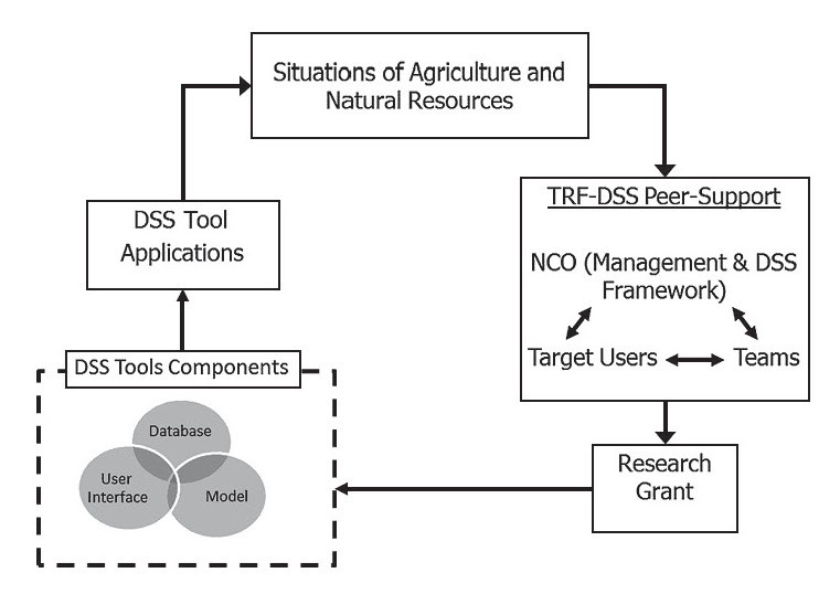
Fig. 1 DSS Development and Application Process as Implemented within TRF-DSS Network
The TRF-DSS network’s mode of operations includes providing peer support, providing DSS funding for 59 DSS research projects, and organizing six annual meetings as a platform for researchers and users to share research progress and experiences. There are 12 research teams from major universities and institutions joining TRF-DSS to conduct research and develop DSS tools to address various agricultural and natural resource issues. The unique feature of TRF-DSS research is its three integral components: agricultural and natural resources in Thailand, the peer-support process, and DSS tool develop ment and applications.
II.1 Situation of Natural Resources and Agriculture in Thailand
The northern region of Thailand covers about one-third of the country (Phrek et al. 1980); 55 per cent and 21 per cent of it have been classified as forestland on mountainous areas and agricultural land, respectively. This region is also home to the four major river basins—Ping, Wang, Yom, and Nan—that join to form the Chao Phraya River in Nakhon Sawan Province. In 2008, Northern Thailand contributed 9.3 per cent to the national GDP and was home to about 12.1 million people, or about 18.1 per cent of the country’s total population. Its per capita income was 51.1 per cent of the national average. In 2008, agriculture contributed about 37.7 per cent to gross regional domestic product at current market prices, the highest percentage as compared to other regions in Thailand (Thailand, NESDB 2010). Current issues in Northern Thailand include pressure on agricultural land and deteriorating natural resources (Leisz et al. 2009), conflicts over water between user groups (Sneddon and Fox 2006; Gizelis and Wooden 2010), and the establishment of the East-West Economic Corridor cross-border highway from Vietnam to Myanmar, with a major section in Laos and Thailand (Medhi 2004).
Northeast Thailand also covers about one-third of the country (KKU-FORD Project 1982), with 17 per cent and 55 per cent of the region being classified as forestland on mountainous areas and agricultural land, respectively. In 2008, this region contributed 10.7 per cent to the national GDP; however, per capita income was only 31.5 per cent of the national average and was the lowest in the country. Current issues in the region include low agricultural productivity, which is a function of low chemical fertilizer inputs (Wijnhoud et al. 2003), low soil fertility, and erratic rainfall patterns (KKU-FORD Project 1982), the latter resulting in frequent droughts and floods.
The Central Plain is the rice bowl of Thailand. Lying within the Chao Phraya-Thachin basin, it covers a land area of 20 per cent of the country’s total. Approximately 28 per cent and 40 per cent of the Central Basin have been classified as forestland on mountainous areas and agricultural land, respectively. The Chao Phraya-Thachin river basin covers 30 per cent of Thailand’s land area and is home to about 40 per cent of the country’s population. Per capita income is 176.8 per cent of the national average. Currently, the Central Plain has few cases of conflict between natural resources and agricultural systems.
The southern part of Thailand covers 14 per cent of the country, with 25 per cent and 44 per cent of the total region being classified as forestland on mountainous areas and agricultural land, respectively. The South is home to approximately 14 per cent of the country’s population, with a per capita income of 72.3 per cent of the national average. The region is facing a rapid expansion of oil palm cultivation for biofuel, which may lead to a higher rate of forest conversion (Fitzherbert et al. 2008).
II.2 TRF-DSS Peer-Support Process
The TRF-DSS peer-support process consists of four major interacting components: the Network Coordination Office, targeting DSS users, DSS framework, and DSS research teams.
Network Coordination Office Management
The Network Coordination Office for TRF-DSS was established in Chiang Mai University, Thailand, with one coordinator and two supporting staff. During the 2002–10 calendar years, TRF-DSS was allocated a total of 140.1 million baht to support DSS research projects, 1.5 million baht to support post-DSS project activities, and 15.4 million baht to support TRF-DSS networking activities. A total of 59 DSS research projects and 10 post-DSS project activities were given grants to conduct research and development on DSS tools and components. Included in the 59 DSS research projects were 3 DSS-oriented human resources development (HRD) projects, in which scholarships for master of sciences and doctorate degrees were granted to individuals in Lao PDR, Thailand, and Vietnam to pursue their degrees in Chiang Mai University and Khon Kaen University. The grant contracts were signed by the TRF director and the head of the organization, i.e., the president of the awarded university; and the project leader was the witness of the contract. About 10 per cent to 12 per cent of the total grant budget was earmarked as “institutional fee” or “overhead charge fee” for each organization, except for line agencies that were mandated to conduct research, for example, the Department of Agriculture. Once the contract was signed by both sides, funds were transferred to the bank account for researchers to manage their itemized funds for supporting their research activities. This was a new approach to research budget in Thailand, whereby researchers were responsible for mobilizing resources to achieve “agreed” final research products.
TRF-DSS realizes the importance of an interdisciplinary approach to deal with issues of agricultural and natural resources management, including the biophysical, socioeconomic, ecological, environmental, and information technology aspects. Broadly speaking, a DSS tool is computer software that facilitates and accepts digital inputs of a large number of facts and methods and converts them into meaningful comparisons, graphs, and trends that can facilitate and enhance decision-making processes and outcomes. A DSS tool can assist users in processing, assessing, categorizing, and/or organizing information in a useful fashion such that it can be easily retrieved in different forms. In agricultural and natural resource management, users can employ a DSS to address “what-if?” questions posed by stakeholders when faced with ill-structured situations (Uehara and Tsuji 1998). To guide its work, TRF-DSS uses a “peer-supported” approach to promote “active engagement” of users and research teams in order to effectively develop a research proposal and to implement DSS tools. A peer-supported approach is one whereby users, research teams, and the TRF-DSS coordinator develop an understanding of the situation and formulate a sound research proposal for grant approval. The approach promotes an understanding of how users and research teams can utilize DSS tools to actively engage in addressing “what-if?” questions to improve a situation, using the defined DSS framework within the TRF-DSS research and development network in Thailand.
DSS’s Targeted Users
In provincial and local organizations in Thailand, computer-based information systems that combine various components—such as hardware, software, data, people, and procedures—to provide a decision-making system have recently become increasing visible and important. However, most applications are in electronic data processing tools, and some applications have moved to a management information system, but none have moved to a DSS tool. TRF-DSS has introduced the principles and practices of DSS to users in provincial and local organizations and demonstrated that proper implementation of DSS tools can increase effectiveness and allow a visualization of various alternatives, promote learning, and facilitate communication within and between organizations. DSS users in Thailand may be classified into three types: users dealing with and making decisions in situations within administrative boundaries, users dealing with and making decisions in situations within natural boundaries, and users dealing with and making decisions on specific issues.
DSS Framework
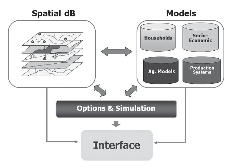
All DSS tools share a common structure (Sprague and Carlson 1982; Bhatt and Zaveri 2002) consisting of digital databases, dynamic simulation models or analytical tools, and a user interface with the Thai language (Fig. 2). DSS tool development in Thailand can be divided according to three groups of users (Table 1): (1) DSS tools for users making decisions within a given administrative boundary; (2) DSS tools for users making decisions across administrative boundaries under situations within a natural boundary, such as a watershed boundary, national park boundary, or special economic zone; and (3) DSS tools for users making ad hoc decisions or deciding on specific issues related to agricultural systems or natural resources.
DSS Tools for Users Making Decisions within Administrative Boundaries
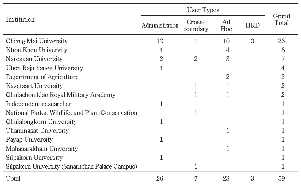
In 2002–10, a total of 26 research projects were conducted for DSS users making decisions within administrative boundaries, and 37 per cent of the network budget was allocated (Tables 1 and 2). The TRF-DSS network identified two types of users for this DSS category: officials in provincial offices and officials in the Tambon Administrative Organization. Currently, both types of users make decisions based on historical and non-digital format data sets. TRF-DSS research teams together with the users identified the need to develop DSS tools to support data integration for their planning and tasks to deal with agricultural production reports and natural disaster management, i.e., floods and drought affecting agricultural production systems. In general, the system contains databases related to administrative boundaries, population, soil maps, land-use maps, water resources, and transportation networks. The DSS tools are designed to allow users to view all stored data on a Thai-language platform and to allow communications for decision making to be based on provincial and local administrative boundaries.
Table 1 Number of DSS Projects Carried Out by Researchers in Each Institution for Various Users under TRF-DSS Network in Thailand during 2002–10
Source: (TRF 2011)
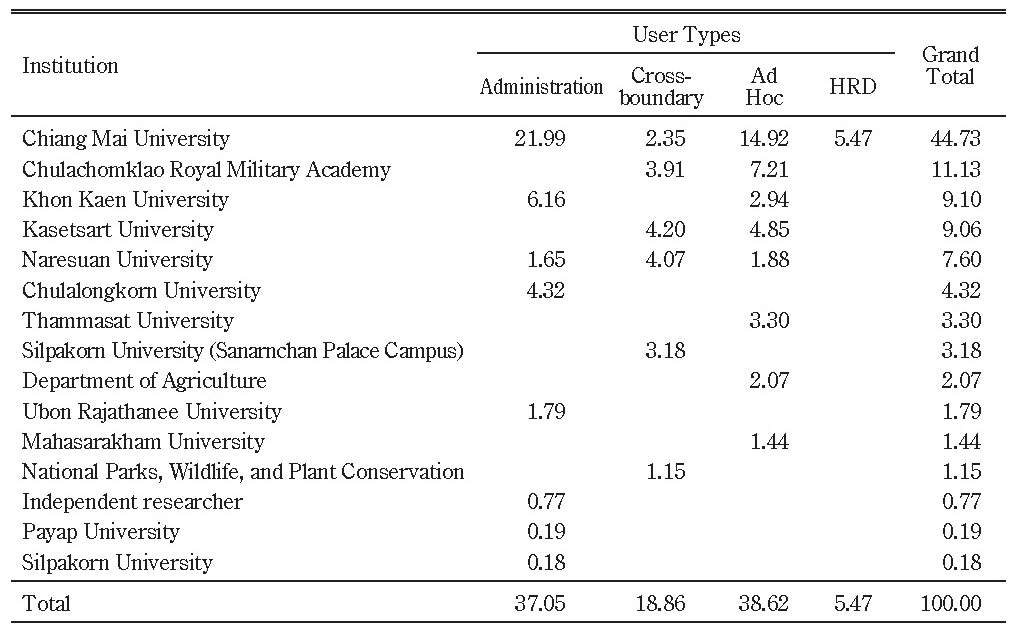
Table 2 Percentage of Budget Allocation to DSS Tool Development for Various Users under TRF-DSS Network in Thailand during 2002–10
Source: (TRF 2011)
DSS Tools for Users Making Decisions within Natural Boundaries
Only seven research projects were conducted for users making decisions within natural boundaries, and 19 per cent of the network budget was allocated (Tables 1 and 2). The pressure on natural resources, i.e., land and water, is continuously increasing in Thailand, and managing these resources collectively and sustainably is a challenge. Therefore, natural boundary systems, for instance watershed or park boundaries, require DSS users to make decisions across administrative boundaries. Such DSS tools must allow users to combine and integrate data from various sources, with a simple-to-use interface, allow communications and coordination among agencies, and contain features of complex systems.
DSS Tools for Users Making Decisions in Special Situations or Ad Hoc Cases
A total of 23 research projects were conducted for users making decisions in special situations or ad hoc cases, and 39 per cent of the network budget was allocated (Tables 1 and 2). Situations beyond administrative and natural boundaries are grouped in the “special issues” category, for instance the impact of climate variability and change on agriculture and natural resources, or a cultural study of the Royal Road from Angkor Wat in Cambodia to Phimai in Thailand. DSS tools can also be used to facilitate communication between researchers from various backgrounds and countries when dealing with a common situation. Users engaged in medium- and long-term planning are the main users targeted for these types of DSS tools. DSS tools in this category are designed to link climate change scenario data sets, with common data definitions, to process-oriented simulation models. The latter involves an Internet-based interface that is designed to allow communications and coordination among agencies and contains features of complex systems.
TRF-DSS Research Teams
Chiang Mai University
The Chiang Mai University research team—as a research unit of the Multiple Cropping Center, Faculty of Agriculture—is the team that introduced the DSS concept and practices into research agenda in Thailand during the early 1990s (Methi et al. 2005). The Multiple Cropping Center was established in the 1970s, with a mandate to conduct research to improve the performance of agricultural systems, using various systems approaches, namely, agro-ecosystem analysis (Phrek et al. 1980). Under the DSS research unit, a number of DSS tools have been developed for a variety of application purposes and users, including administrative, non-administrative, and special issues. The application of one of its projects titled “A Support System for Planning to Manage Resources for Agriculture and Services,” started in 2002, has been very successful in terms of its far-reaching impact at the provincial administrative level.
Currently, the main DSS research field includes the development of information technology to support decision making using non-numerical data sets and crop production knowledge management.
Khon Kaen University
Since the mid-1970s, research activities at the Faculty of Agriculture, Khon Kaen University, have focused on cropping systems, farming systems research, agro-ecosystems analysis, and Rapid Rural Appraisal. DSS research was introduced as part of agro-ecosystem analysis in the early years of the twenty-first century.
At present, the main research topics include applications of existing DSS tools to improve performance of agricultural systems in the rainfed environment of Northeast Thailand as well as at the local community and provincial levels.
Chulachomklao Royal Military Academy, Thailand Fine Arts Department, Silpakorn University, APSARA Authority Cambodia, and Prince of Songkla University
In 2005 a bi-national research team from three universities and two national agencies was formed to conduct research, using a multidisciplinary approach, to study the Royal Road from Angkor Wat in Cambodia to Phimai city in Thailand, as the social science and tourism part of DSS. In this research, the team studied the ancient road in detail—its utilization, the people who lived and used this road, the ancient industries along this road, the culture that disappeared, and the culture that continues to flourish along the Royal Road until today. Current technologies were applied in the fields of remote sensing, GIS, archeology, anthropology, and geophysics. Information systems were developed to gather information from this study for scholars to use. In addition, data that were developed from this project can be further utilized by related works in the fields of land-use planning related to cultural management, tourism, etc.
Currently, the research is expanding to study the relationship between ancient and near-present culture in the Greater Mekong Subregion (GMS) and the Malay Peninsula.
Ubon Rajathanee University
In recent years, DSS researchers from the Faculty of Agriculture at Ubon Rajathanee University have focused on three main fields: (1) Database development for local organizations; (2) decision making and DSS development in local organizations, such as sustainable agricultural production; and (3) systems simulation using intelligent systems technology such as the agent-based simulation platform. The relevant concepts of the main research fields are developed based on the needs of the community.
Recent research emphasizes extending DSS tools to local organizations at the provincial level to support planning, agricultural project improvement, and management. Expanding DSS applications has become a key policy of provinces in lower Northeast Thailand, which are engaged in accelerated rural development.
Thammasat University at Rangsit Center and Asian Institute of Technology
The collaborative project between the Department of Geography, Faculty of Liberal Arts, Thammasat University, and the Remote Sensing and Geographic Information System field of study at the School of Engineering and Technology, Asian Institute of Technology, aims to assess the effects of climate variability (especially droughts or dry spells) on rice production in rainfed environments and to develop a DSS tool that might help to properly anticipate and adapt farming to maximize agricultural production.
Current research activity focuses on using DSS tools to support real-time/near-real-time weather information in rainfed environments, early warning on rice disease (probability), and yield estimation, including suggestions on response and adaptation methods/strategies for rice cropping under climate variables (based on the rice knowledge bank and experts). The DSS tool developed is expected to be a crucial source of information for stakeholders: farmers, agricultural officers/researchers, and policy makers/planners at local and regional levels.
Department of Agriculture, Rice Department, and Land Development Department of Ministry of Agriculture and Cooperatives
The team from the Department of Agriculture, Rice Department, and the Land Development Department of the Ministry of Agriculture and Cooperatives consists of individual researchers who have been participating in a series of training workshops on using crop growth simulation models since the early 1990s. The team began its DSS research and development in the early years of the twenty-first century and has been testing and implementing DSS tools to study yield gaps of rice, cassava, sugar cane, and maize in major growing areas of Thailand. Current research activities focus on conducting field experiments to generate data for model testing and validation in major ecosystems in Thailand.
Naresuan University
Established as a regional university in the lower northern region of Thailand in 1990, Naresuan University has developed a good reputation. DSS research activity was begun there in 2001 by a team of researchers from the Faculty of Agriculture, Natural Resources, and Environment. The research area focuses on applications of geo-informatic technologies and the development of spatial DSS tools for agricultural systems planning. The recently developed spatial DSS tool “Rabeang Settakit” was devised to compile various databases from local agencies in 12 provinces along Thailand’s East-West Economic Corridor. As a spatial-based dialogue DSS tool, Rabeang Settakitt is useful for policy planners, local administrators, and those who are involved in local policy and plan analysis or local resource management aimed at rural economic development. This tool enables users to generate scenarios of resource utilization, disaster risk management, and rural socioeconomic development. It can display output information in both graphical map and attribute forms at the village level or at the tambon administrative boundary. By using Rabeang Settakitt DSS tool, users can explore fields or alternatives that fit with defined goals or decision criteria of a specified area.
Currently, the team is developing a DSS tool for establishing an index-based rice crop insurance system using scientific, technological, and social approaches. Under the collaboration of five organizations from the government and private sectors, the rice crop insurance project covers 14 provinces of Thailand.
III Selected DSS Tools and Applications in Thailand
III.1 DSS for Natural Agricultural and Natural Resource Management at Provincial Level
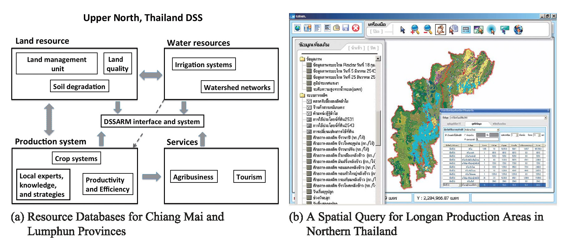
Fig. 3 displays the basic structure and analysis window of the DSSARM shell, designed to allow users at the provincial level to compile, store, and visualize spatial data sets from various provincial agencies on one stand-alone platform. The shell integrates spatial and attribute data of Chiang Mai and Lumphun Provinces in Northern Thailand, and provincial officers have been trained in installing and applying the shell to communicate among agencies. Currently the shell is in its second version and is being applied in other provinces in Thailand—Lumphun Province in the North and Kalasin Province in the Northeast.
III.2 DSS for East-West Economic Corridor
Recently there has been an increase in the number of projects that cross provincial boundaries. One example of such a project is the East-West Economic Corridor (Chada 2011). The project team developed a database and display interface on the Internet (http://www.map.nu.ac.th) for users to view various types of data (Fig. 4).
Users can view a total of 18 data layers: Administration, Collection points, Crops, Disasters, Food security, Infrastructure, Meteorology, Places, Resources, Rice, Sheets, SMEs, Topography, Tourism, Village Index, Wind, Water, and Water resources.
III.3 DSS for Living Angkor Road Project
The Living Angkor Road project, which is a collaborative project between Chulachomklao Royal Military Academy, Thailand Fine Arts Department, Silpakorn University, APSARA Authority Cambodia, and Prince of Songkla University, demonstrates the application of geo-informatics technology, using a multidisciplinary approach, in cultural study—in this case the study of Cambodia’s Royal Road from Angkor to Phimai (Surat and Shibayama 2009) (Fig. 5).
More information is available at http://larp.crma.ac.th (Surat 2011).
III.4 DSS Tools for Studying Effects of Weather Patterns on Rainfed Rice Production Systems
In one study, two real-time weather observation systems were developed in a large rainfed rice field in Ubonratchathani Province, Northeast Thailand, to provide crop-growth-related parameters for model calibration, simulation, and validation. Actual evapotranspiration (ETa) was estimated from a series of MODIS data using SEBAL (Surface Energy Balance Algorithm for Land). A simulation using the RS-SWAP-GA (Remote Sensing – Soil Water Atmosphere Plant – Genetic Algorithm) method was developed to estimate the spatial and temporal variations of soil moisture and yield in the study area under different dry spell scenarios. Although the analysis revealed the advantage of remote sensing data at the provincial level, cloud contamination during the cropping season imposed limitations on the quantity and accuracy of data. The approach requires a minimum of 15 per cent of remote sensing data in a year to calibrate a crop simulation model. More information and details can be found at http://203.159.10.20/weather/TRF_Drought/Home.php (Honda 2011).
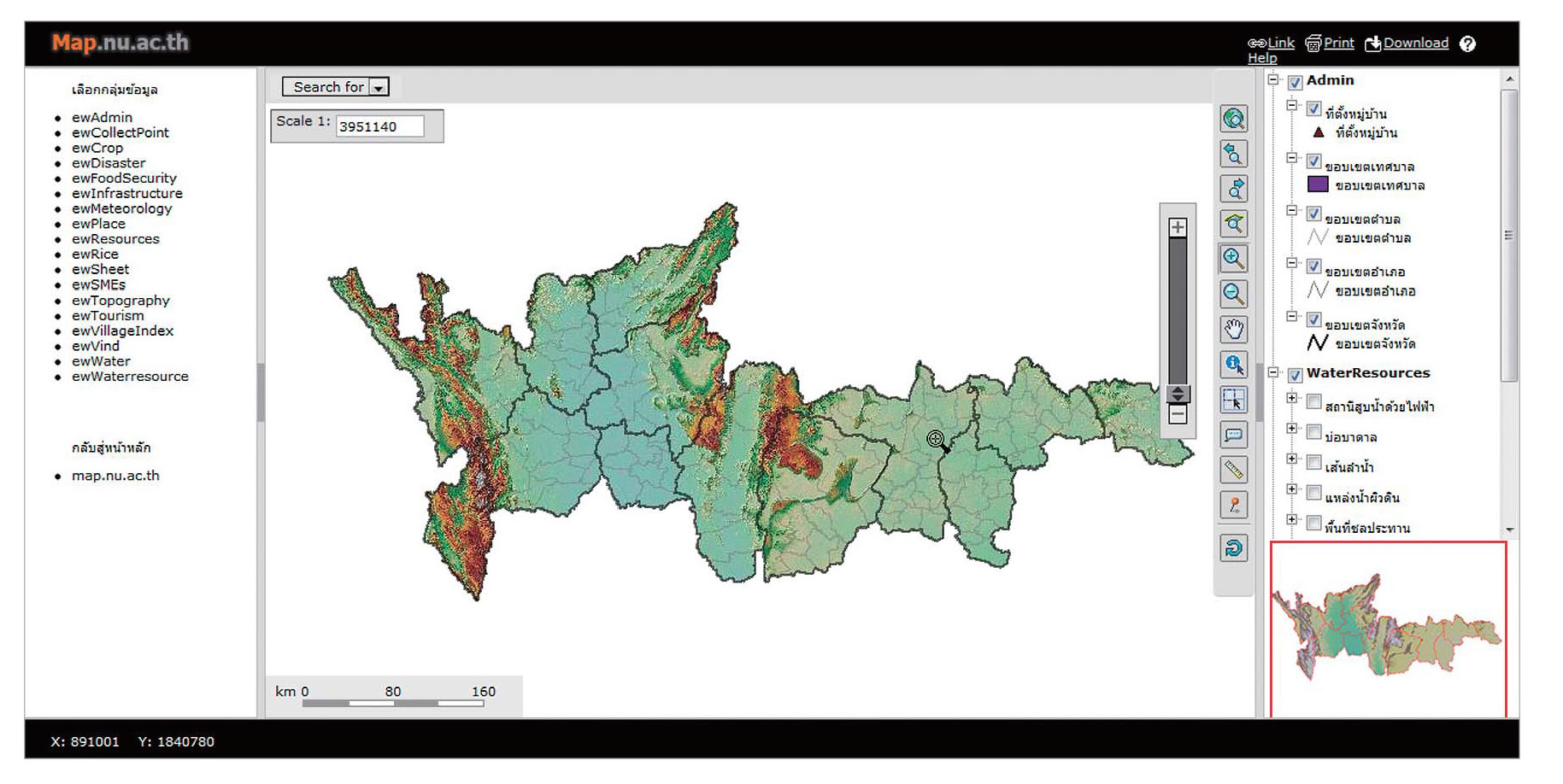
Fig. 4 East-West Economic Corridor Web-based Interface (http://map.nu.ac.th)
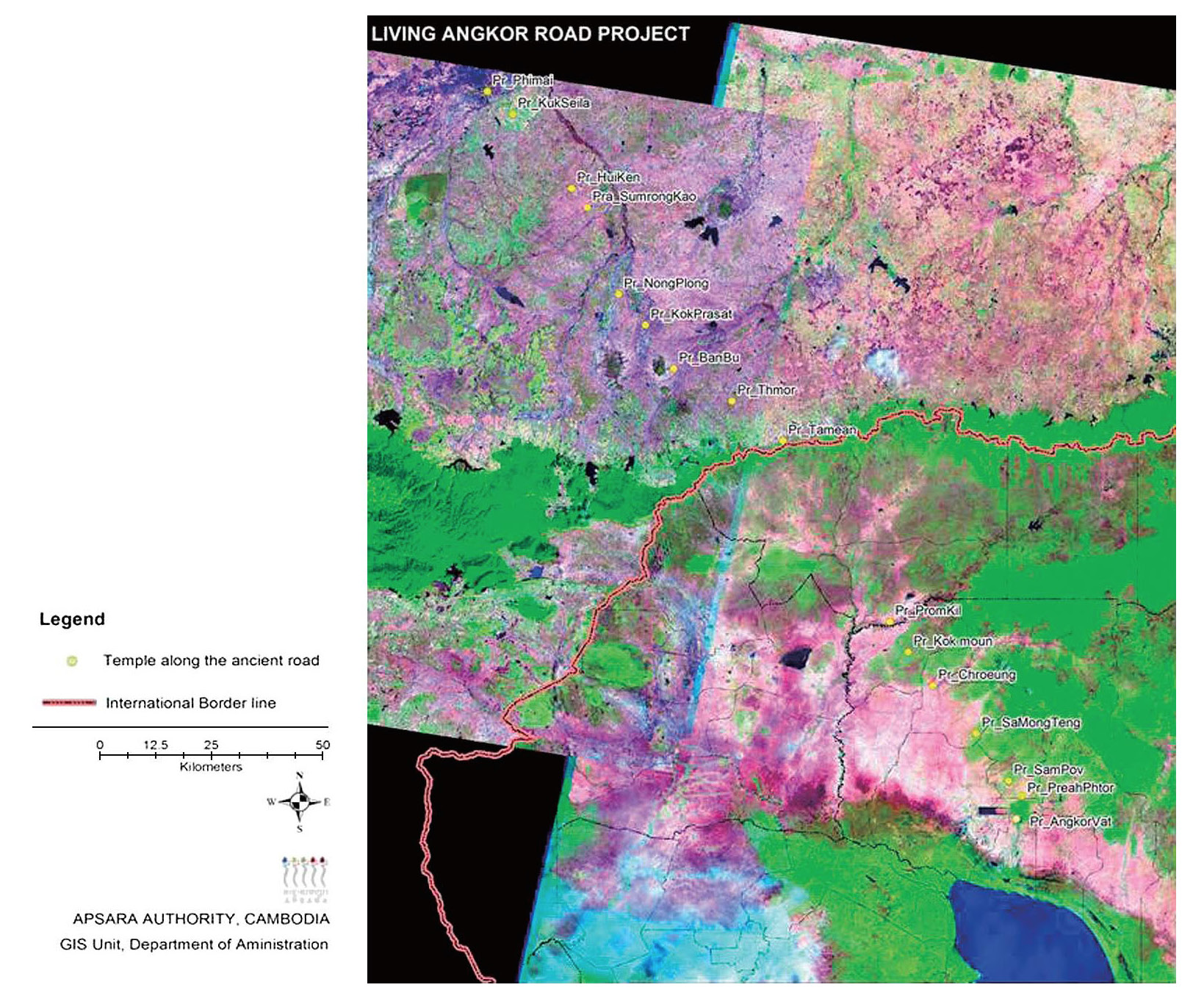
Fig. 5 Rest Houses ( thamma sala) along the Royal Road from Ankor Wat in Cambodia to Phimai in Thailand
Source: (Surat and Shibayama 2009)
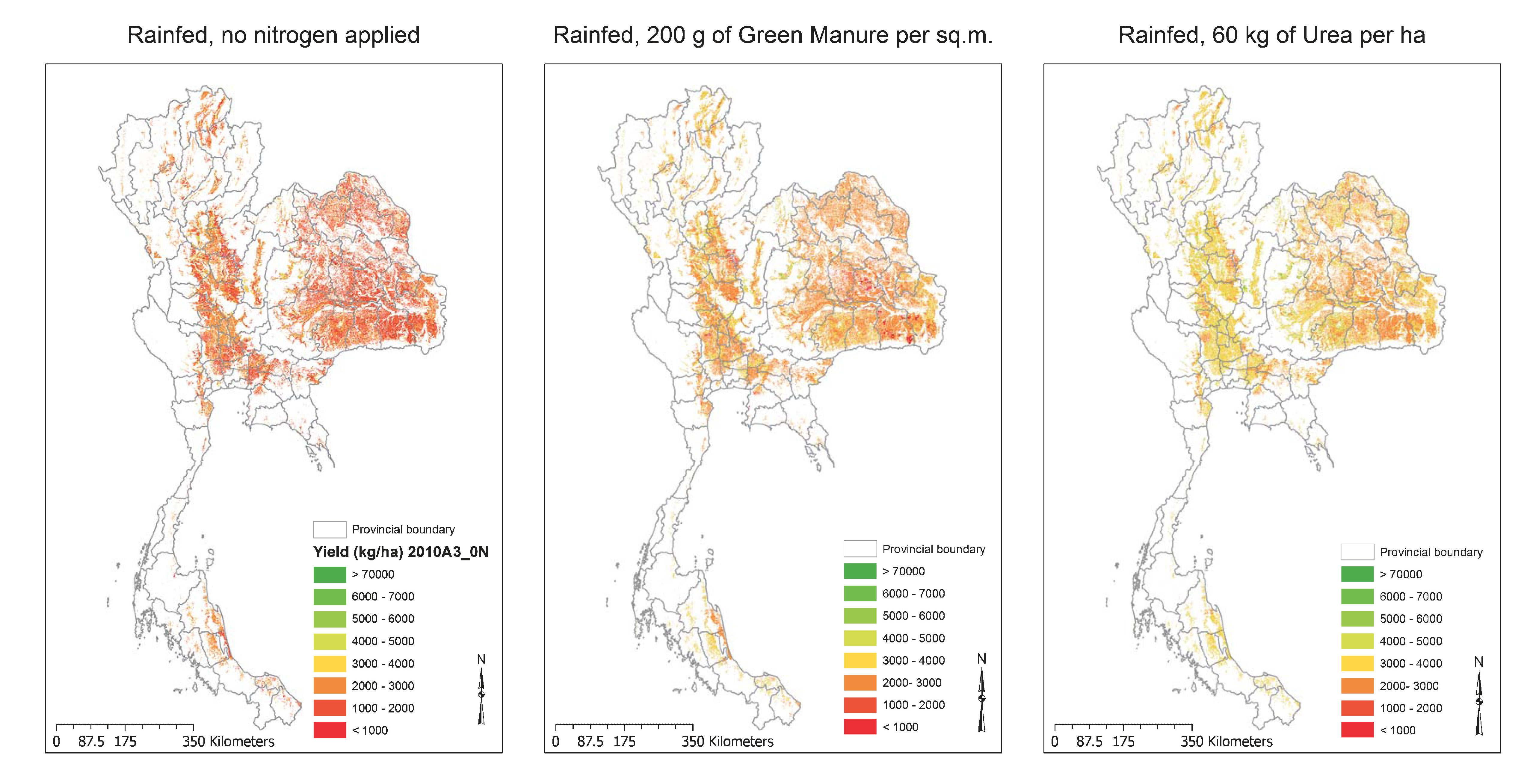
Fig. 6 Distribution of Simulated Rice Yields (kg/ha) in Thailand under ECHAM4 A2 SRES Scenario during 2010s for Three Production Options
Source: (Attachai and Suppakorn 2011)
III.5 DSS for Assessing Impact of Climate Change on Crop Production Systems
The CropDSS shell was developed to link the DSSAT4.5 (Decision Support System for Agrotechnology Transfer version 4.5) crop growth simulation models (Hoogenboom et al. 2003; Jones et al. 2003) with future climate scenarios from the ECHAM4 Global Climate Model for Thailand (Attachai 2009a). The CropDSS shell allows users to link four spatial databases—administrative, crop planted areas, soil boundary, and climate grid maps—with DSSAT4.5 models. The crop models that have been extensively tested in Thailand require a minimum data set of climate data such as solar radiation, temperature, rainfall, soil profile characteristics, crop genetics characteristics, and crop management. Users may use the CropDSS program to study the impact of climate change on agricultural systems in an integral approach, for instance, the impact on rice production in Thailand (Fig. 6).
The CropDSS program has been used to assess the impact of climate change on the rice (Chitnucha and Attachai 2009), cassava, sugar cane, and maize (Somchai et al. 2009) production systems in Thailand, using ECHAM4 SRES A2 and B2. As a result, a change in policy planning for climate change adaptation under the direction of the National Economic and Social Development Board (NESDB) was to use CropDSS to assess the impact of climate change on four major crops in Thailand: rice, cassava, sugar cane, and maize.
IV Future Prospects
The future prospects of TRF-DSS in regional agricultural and natural resource research depend on demand and supply of DSS tools by various users and researchers, which may include both private and public sector organizations dealing with local and regional issues. TRF has supported TRF-DSS for eight years to demonstrate that DSS tools can be developed provided the demand exists. However, TRF-DSS is a flexible network of researchers with common research interests, a DSS framework, and funding to generate results. Demand from other agencies, both private and public, is the key to future activities and contributions of TRF-DSS for Thailand and Southeast Asia. The challenge is to build bridges between these emerging research communities and well-established research in developed countries as well as the private sector (Brimble and Doner 2007). This challenge may be met by establishing a well-structured and well-organized DSS research infrastructure in Thailand as a platform to create and maintain a critical mass of research supplies.
Thailand will benefit tremendously from regional collaboration, especially in Southeast Asia. Collaborative DSS research projects will help solve local as well as regional agricultural issues and natural resource management problems. Thailand enjoys a worldwide market for agricultural exports. However, with the changing global environment and various regional economic agreements, DSS tools have the potential to help Thailand build a collaborative platform in the region.
V Conclusion
This paper carries an introduction to the DSS (Decision Support System), which is an area informatics approach in area studies, and the research network complex based on DSS’s application in Thailand. The paper focuses on the TRF-DSS research and development network, consisting of 12 universities, two line agencies in Thailand, and a line agency in Cambodia during 2002–10. The development of DSS tools for agricultural and natural resource management was independently started in Thailand during the early 1990s by research units in various universities. The TRF-DSS research and development network was established in 2002 to provide a network platform and financial support for DSS research, development, and implementation. It has proven effective in promoting DSS research and development, having built a strong record of research achievement. The network combines the power of digital networking with the collaborative facilitation offered by peer-support communities, to support decisions on sustainable agricultural and natural resource management in Thailand. Furthermore, it has created synergies among groups and information exchange among the disciplines of agricultural and natural resource sciences, and information science.
Although DSS users in various agencies, both public and private, can implement the tools to address issues in agricultural and natural resource management, the effectiveness of DSS depends less on the technical or theoretical aspects of the tools themselves than on the institutional and socio-political environment that determines the issues and the resources available (Matthews et al. 2008).
DSS tools have led to cooperation and co-learning with other disciplines and agencies, and there is now a feeling among researchers and DSS users in Thailand that there is a need to reinforce their integration with agricultural and natural sciences, using the TRF-DSS research framework. Furthermore, advances in DSS research have clearly identified some research questions in the various fields in which networking and collaboration can contribute to the more sustainable development of agricultural systems and natural resource management. The establishment of TRF-DSS can also contribute to defining the integral role of research conducted by agricultural and natural resource scientists within the interdisciplinary framework of DSS, based on the need to address the sustainability of production systems under various climate change scenarios. Such research may lead to poverty reduction and improvement of food security levels.
Some of the lessons learned during the implementation of TRF-DSS are as follows. DSS tools are a decision support system, not a decision-making system. A funding commitment is required to effectively support research teams to collectively develop and implement DSS tools for various users, with a wide array of issues related to agriculture and natural resources. It is important to involve users in DSS development and testing at a very early stage of a research project. Funding is only one factor in a successful DSS research project; bureaucratic rules and developing collaborative agreements with other agencies are also important factors for project leaders to consider during the course of the project. Successful DSS implementation also depends on training and documentation to the end users. Training sessions can be carried out in the form of workshops to expose users to various DSS components, functions, and limitations. Finally, networking of research teams, funding agencies, and users in agricultural systems and natural resource management provides a platform for communication based on the same data sets. Lessons learned from the TRF-DSS network may be applied to other issues in Thailand and elsewhere, for example the application and implementation of area informatics to improve an understanding of the relationships between urban and rural communities (Shibayama 2009). The discussed research and development network platform and its results have the potential to provide a strong base for implementing various research area studies agenda to understand the interrelationships between physical environments and resources and suggest a Best Management Practice in the Southeast Asian region.
Acknowledgments
The author dedicates this paper to the first coordinator of the TRF-DSS network, the late Arjan Amnat Korvanich, who tragically passed away in a road accident in February 2007. The Thailand Research Fund is acknowledged for its initiative and continuous financial support to various DSS networking activities in Thailand since 2002, under grant numbers NIC45O0001, RDC48O0003, and RDC52O0001. The author also appreciates all project leaders and researchers of the TRF-DSS research and development network. In addition, the author expresses his appreciation to Karnpitcha Bunsiri and Nittaya Chaiyasit for their NCO support since 2000. The author completed the manuscript while taking a sabbatical, during December 2010 to May 2011, as a visiting research fellow at the Center for Southeast Asian Studies in Kyoto University, Japan, under Professor Dr. Mamoru Shibayama of the Area Informatics Program.
References
Amnat Korvanich อำนาจ คอวนิช. 2009 (2552). Krop lae phap ruam kan sanapsanun thun wichai phattana rabop sanapsanun kan tatsinchai pp. 1–8 กรอบและภาพรวมการสนับสนุนทุนวิจัยพัฒนา-ระบบสนับสนุนการตัดสินใจ หน้า ๑-๘ [A framework for Decision Support Systems re search and development funding under Thailand Research Fund]. In Sarup phon ngan rop 6 pi (2546–2551) Khrueakhai wichai lae phatthana rabop sanapsanun kan tatsinchai สรุปผลงานรอบ ๖ ปี (๒๕๔๖-๒๕๕๑) เครือข่ายวิจัยและพัฒนาระบบสนับสนุน-การตัดสินใจ [The Thailand Research Fund-Decision Support Systems Research and Development Network (TRF-DSS): A summary of six years achievements (2003–08)], pp. 1–8. Chiang Mai: Thailand Research Fund.
Attachai Jintrawet อรรถชัย จินตะเวช. 2009a (2552a). Rabop sanapsanun kan tatsinchai pheua sueksa phon krathop kan plianplaeng saphap phumiakat lok to rabop kan phalit ahan ระบบสนับสนุนการตัดสิน-ใจเพ่ือศึกษาผลกระทบการเปล่ียนแปลงสภาพภูมิอากาศโลกต่อระบบการผลิตอาหาร [A Decision Support System to study the impact of climate change on food production systems]. Khon Kaen University Research Journal 14(7): 589–600.
―. 2009b (2552b). Bot thi 5 sarup ngan 6 pi lae thitsthang kan wichai pheua kan chai ngan pp. 119–121 nai Sarup phon ngan rop 6 pi (2546–2551) khrueakhai wichai lae phatthana rabop sanapsanun kan tatsinchai บทท่ี ๕ สรุปงานหกปีและทิศทางการวิจัยเพ่ือการใช้-งาน หน้า ๑๑๙-๑๒๑ [Chapter 5: A six year summary and future research directions for implemen tations]. In Sarup phon ngan rop 6 pi (2546–2551) Khrueakhai wichai lae phatthana rabop sanapsanun kan tatsinchai สรุปผลงานรอบ ๖ ปี (๒๕๔๖-๒๕๕๑) เครือข่ายวิจัยและพัฒนาระบบสนับสนุนการตัดสินใจ [The Thailand Research Fund-Decision Support Systems Research and Development Network (TRF-DSS): A summary of six years achievements (2003–08)], pp. 119–121. Chiang Mai: Nopparat Press.
Attachai Jintrawet; and Suppakorn Chinvanno. 2011. Assessing Impacts of ECHAM4 GCM Climate Change Data on Main Season Rice Production Systems in Thailand. APN Science Bulletin 1: 29–34.
Bhatt, G. D.; and Zaveri, J. 2002. The Enabling Role of Decision Support Systems in Organizational Learning. Decision Support Systems 32(3): 297–309.
Brimble, P.; and Doner, R. F. 2007. University-Industry Linkages and Economic Development: The Case of Thailand. World Developmentt 35(6): 1021–1036.
Chada Narongrit. 2011. Research, Development, and Technology Transfer for Database and DSS Tools. Retrieved January 28, 2011, from http://www.map.nu.ac.th/map/mapew.phtml?config=ewWaterresource.
Chitnucha Buddhaboon; and Attachai Jintrawet ชิษณุชา บุดดาบุญ และ, อรรถชัย จินตะเวช. 2009 (2552). Phon krathop khong saphawa lok ron to kan phalit khao nai phuenthi lum Nam Chi-Mun ผลกระทบ ของสภาวะโลกร้อนต่อการผลิตข้าวในพ้ืนท่ีลุ่มน้ำชี-มูล [Impacts of climate change on rice production systems in Chi-Mun river basin]. Khon Kaen University Research Journal 14(7): 611–625.
Cox, P. G. 1996. Some Issues in the Design of Agricultural Decision Support Systems. Agricultural Systems 52(2–3): 355–381.
Dennis, C.-L. 2003. Peer Support within a Health Care Context: A Concept Analysis. International Journal of Nursing Studies 40(3): 321–332.
Fitzherbert, E. B.; Struebig, M. J.; Morel, A.; Danielsen, F.; Brühl, C. A.; Donald, P. F.; and Phalan, B. 2008. How Will Oil Palm Expansion Affect Biodiversity? Trends in Ecology & Evolution 23(10): 538–545.
Food and Agriculture Organization (FAO). 2007. Selected Indicators of Food and Agricultural Development in the Asia-Pacific Region 1996–2006. Bangkok: Food and Agriculture Organization.
Fukui, H. 1993. Food and Population in a Northeast Thai Village. Honolulu: University of Hawai‘i Press.
Gizelis, T.-I.; and Wooden, A. E. 2010. Water Resources, Institutions, and Intrastate Conflict. Political Geography 29(8): 444–453.
Grandstaff, T. B.; Grandstaff, S.; Limpinuntana,V.; and Suphanchaimat, N. 2008. Rainfed Revolution in Northeast Thailand. Southeast Asian Studies 46(3): 289–376.
Honda, K. 2011. Drought Monitoring and Impact Assessment on Rice in Lower Part of Northeastern Thailand for a Basis of Decision Support System. Retrieved January 28, 2011, from http://203.159.10.20/weather/TRF_Drought/Home.php.
Hoogenboom, G.; Jones, J. W.; Porter, C. H.; Wilkens, P. W.; Boote, K. J.; Batchelor, W. D.; Hunt, L. A.; and Tsuji, G.Y. 2003. Decision Support System for Agrotechnology Transfer Version 4.0. Vol.1: Overview. Honolulu: University of Hawai‘i.
Jones, J. W.; Hoogenboom, G.; Porter, C. H.; Boote, K. J.; Batchelor,W. D.; Hunt, L. A.; Wilkens, P. W.; Singh, U.; Gijsman, A. J.; and Ritchie, J. T. 2003. The DSSAT Cropping System Model. European Journal of Agronomy 18(3): 235–265.
KKU-FORD Project. 1982. An Agroecosystem Analysis of Northeast Thailand. Faculty of Agriculture, Khon Kaen University, Khon Kaen, Thailand.
Leisz, S. J.; Kono, Y.; Fox, J.; Yanagisawa, M.; and Rambo, T. A. 2009. Introduction. Southeast Asian Studies 47(3): 237–243.
Matthews, K. B.; Schwarz, G.; Buchan, K.; Rivington, M.; and Miller, D. 2008. Wither Agricultural DSS? Computers and Electronics in Agriculture 61(2): 149–159.
McCown, R. L. 2002. Locating Agricultural Decision Support Systems in the Troubled Past and Socio-technical Complexity of “Models for Management.” Agricultural Systems 74(1): 11–25.
Medhi Krongkaew, M. 2004. The Development of the Greater Mekong Subregion (GMS): Real Promise or False Hope? Journal of Asian Economics 15(5): 977–998.
Methi Ekasingh; Chanchai Saengchyosawat; Chalermpol Samranpong; Pinpetch Sakulsongboonsiri; Phraphassorn Pansompong; Charit Soomham; Wattana Pattanathaworn; and Chatnapa Prommanon เมธี เอกะสิงห์, ชาญชัย แสงชโยสวัสด์ิ, เฉลิมพล สำราญพงษ์, ป่ินเพชร สกุลส่องบุญศิริ, ประภัสสร พันธ์สมพงษ์, ชาฤทธ์ิ สุ่มเหม, วัฒนา พัฒนาถาวร, และฉัตรนภา พรหมานนท์. 2005 (2548). Rabop sanapsanun kan wangphaen chatkan sapphayakon phuea kan kaset lae kan borikan raya thi 1 phak nuea tonbon: kan chai sapphayakon lae rabop sanapsanun kan tatsinchai (rabop klang) ระบบสนับสนุนการ-วางแผน จัดการทรัพยากรเพ่ือการเกษตรและการบริการ ระยะท่ี 1 ภาคเหนือตอนบน: การใช้ทรัพยากรและ ระบบสนับสนุนการตัดสินใจ (ระบบกลาง) คณะเกษตรศาสตร์ มหาวิทยาลัยเชียงใหม่ [Decision Support System for planning of agricultural resources management and services 1st phase upper north Thailand: Resources utilization and decision support system (the core system)]. Faculty of Agriculture, Chiang Mai University, A Final Report of a Research Project no. NIG450006, submitted to the Thailand Research Fund (TRF).
Mysiak, J.; Giupponi, C.; and Rosato, P. 2005. Towards the Development of a Decision Support System for Water Resource Management. Environmental Modelling & Software 20(2): 203–214.
Phrek Gypmantasiri; Aree Wiboonpongse; Benjavan Rerkasem; Ian Craig; Kanok Rerkasem; Laxmi Ganjanapan; Manus Titayawan; Manu Seetisarn; Pichit Thani; Rapeepan Jaisaard; Somchai Ongprasert; Tavatchai Radanachalress; and Gordon R. Conway. 1980. An Interdisciplinary Perspective of Cropping Systems in the Chiang Mai Valley: Key Questions for Research. Chiang Mai: Tippanetr Press.
Plucknett, D. L.; and Smith, N. J. H. 1984. Networking in International Agricultural Research. Science 225(4666): 989–993.
Power, D. J. 2002. Decision Support Systems: Concepts and Resources for Managers. Westport: Greenwood/Quorum Books.
Shibayama, M. 2009. Development of Area Informatics: A New Paradigm in Area Studies Introduction. Southeast Asian Studies 46(4): 492–495.
Silaporn Buasai; and Suchata Chinachitra สีลาภรณ์ บัวสาย, และสุชาตา ชินะจิตร, eds. 2009 (2552). Kae roi 16 pi so ko wo แกะรอย 16 ปี สกว. [The Thailand Research Fund (TRF) history]. Bangkok: Thailand Research Fund.
Sneddon, C.; and Fox, C. 2006. Rethinking Transboundary Waters: A Critical Hydropolitics of the Mekong Basin. Political Geography 25(2): 181–202.
Somchai Boonpradub; Sukit Ratanasriwong; Vinai Sarawat; Precha Kapetch; Kathaliya Ek-un; Wibharat Damrhikhemtrakul; Issara Buddhasimma; and Krirk Pannangpetch สมชาย บุญประดับ, สุกิจ รัตนศรีวงษ์, วินัย ศรวัต, ปรีชา กาเพ็ชร, แคทลิยา เอกอุ่น, วิภารัตน์ ดำริเข้มตระกูล, อิสระ พุทธสิมมา, และเกริก ป้ันเหน่งเพ็ชร. 2009 (2552). Phon krathop khong saphawa lok ron to kan phalit phuek rai lak sam chanit khong prathet Thai. ผลกระทบของสภาวะโลกร้อนต่อการผลิตพืชไร่หลักสามชนิดของประเทศไทย [Impact of global warming on three major field crops production of Thailand]. Khon Kaen University Research Journal 14(7): 626–649.
Sprague, R. H. J.; and Carlson, E. D. 1982. Building Effective Decision Support Systems. Englewood Cliffs: Prentice-Hall.
Surat Lertlum. 2011. Living Angkor Road Project. Retrieved January 28, 2011, from http://larp.crma. ac.th/.
Surat Lertlum; and Shibayama, M. 2009. Application of Geo-informatics to the Study of the Royal Road from Angkor to Phimai. Southeast Asian Studies 46(4): 547–563.
Thailand, National Economic and Social Development Board (NESDB). Samnak ngan khana kamakan phattana settakit lae sankhom hai chat (2543) สำนักงานคณะกรรมการพัฒนาการเศรษฐกิจและสังคมแห่งชาติ. 2011 (2554). Phaen phathana setthakit lae sangkhom haeng chat 2554 แผนพัฒนาเศรษฐกิจและสังคมแห่งชาติ [National Economic and Social Development Plan].
Retrieved March 25, 2011, from http://www.nesdb.go.th/Default.aspx?tabid=62.
―. 2010 (2553). Phalittaphan phak lae changwat pho so 2552 ผลิตภัณฑ์ภาคและจังหวัด พ.ศ. 2552 [Gross regional and provincial products]. Retrieved December 17, 2010, from http://www.nesdb.go.th/Default.aspx?tabid=96.
―. 2007 (2550). Sarup sarasamkhan phaen phatthana setthakit lae sangkhom haeng chat chabap thi 10 (pho so 2550–2554). สรุปสาระสำคัญ แผนพัฒนาเศรษฐกิจและสังคมแห่งชาติ ฉบับท่ี 10 (พ.ศ. 2550–2554) [Summary of the tenth national plan]. Retrieved March 25, 2011, from http://www.nesdb.go.th/Portals/0/news/plan/p10/plan10/data/สรุปสาระสำคัญของแผนพัฒนาฯ%20ฉบับท่ี2010.pdf.
Thailand, National Statistical Office (NSO). 2007. Key Statistics of Thailand 2007. Bangkok: Statistical Forecasting Bureau, National Statistical Office.
Thailand Research Fund (TRF). 2011. Decision Support System Research and Development Network. Grant no. NIC45O0001, RDC48O0003, RDC52O0001.
Uehara, G.; and Tsuji, G. Y. 1998. Overview of IBSNAT. In Understanding Options for Agricultural Production, edited by G. Y. Tsuji, G. Hoogenboom, and P. K. Thornton, pp. 1–7. Dordrecht, Boston, London: Kluwer Academic Publishers. Systems Approaches for Sustainable Agricultural Development.
Wijnhoud, J. D.; Yothin Konboon; and Lefroy, Rod D. B. 2003. Nutrient Budgets: Sustainability Assessment of Rainfed Lowland Rice-Based Systems in Northeast Thailand. Agriculture, Ecosystems & Environment 100(2–3): 119–127.
1) อรรถชัย จินตะเวช Crop Sciences and Natural Resources Department and Center for Agricultural Resource Systems Research, Faculty of Agriculture, Chiang Mai University, Chiang Mai 50200, Thailand e-mail: attachai.j[at]cmu.ac.th
2) ชาญชัย แสงชโยสวัสดิ, ถาวร อ่อนประไพ Crop Sciences and Natural Resources Department and Center for Agricultural Resource Systems Research, Faculty of Agriculture, Chiang Mai University, Thailand
3) เมธี เอกะสิงห์, พฤกษ์ ยิบมันตะสิริ Center for Agricultural Resource Systems Research, Faculty of Agriculture, Chiang Mai University, Thailand
4) เบญจพรรณ เอกะสิงห์ Agricultural Economics and Extension Department and Multiple Cropping Center, Faculty of Agriculture, Chiang Mai University, Thailand
5) ชฎา ณรงค์ฤทธ์ิ Department of Agricultural Science, Faculty of Agriculture, Natural Resources and Environment, Naresuan University, Thailand
6) ดรุณวรรณ กําธรเกียรติ Department of Geography, Faculty of Liberal Arts, Th ammasat University, Thailand
7) 本多 潔, Int’l Digital Earth Applied Science Research Center (IDEAS), Chubu Institute for Advanced Studies, Chubu University
8) วินัย ศรวัต Khon Kaen Field Crop Research Center, Thailand
9) สุกิจ รัตนศรีวงษ์ Nakhonratchasima Agricultural Research and Development Center, Th ailand
10) ปานใจ ธารทัศนวงศ์ Graduate School, Silpakorn University, Thailand
11) สุรัตน์ เลิศล้ำ Chulachomklao Royal Military Academy, Thailand
12) ![]() Department of Archaeology, Royal University of Fine Arts, Phnom Penh, APSARA Authority, Cambodia
Department of Archaeology, Royal University of Fine Arts, Phnom Penh, APSARA Authority, Cambodia
13)![]() Department of Archaeology, Royal University of Fine Arts, Phnom Penh, and Department of Demography and Development, APSARA Authority, Cambodia
Department of Archaeology, Royal University of Fine Arts, Phnom Penh, and Department of Demography and Development, APSARA Authority, Cambodia
14) พงศ์ธนว์ สำเภาเงิน Fine Arts Department, Thailand
15) สุวิทย์ เลาหศิริวงษ์ Nakhon Phanom University, and Plant Science and Agricultural Resources Depatment, Faculty of Agriculture, Khon Kaen University, Thailand
16) เกริก ป้ันเหน่งเพ็ชร, เริงศักด์ิ กตเวทิน Plant Science and Agricultural Resources Department, Faculty of Agriculture, Khon Kaen University, Thailand
17) วสุ อมฤตสุทธ์ิ Department of Horticulture, Faculty of Agriculture, Ubon Rajathanee University, Thailand
18) นรินทร บุญพราหมณ์, ทศพร สาธรวิศิษฐ์ Department of Animal Science, Faculty of Agriculture, Ubon Rajathanee University, Thailand
![]()
