![]()
Contents>> Vol. 9, No. 3
Demarcation of the Yunnan-Burma Tai Minority Area in Warry’s Report of 1891–97: A Critical Evaluation against the Background of Contemporary Chinese Historiography*
Hanli Zhou** and Volker Grabowsky***
*This article is part of the research results from the project (No. 20BZS141) of The National Social Science Fund of China (Zhongguo guojia shehui kexue jijin: 中国国家社会科学基金).
**周寒丽, Asien-Afrika-Institut, Universität Hamburg, Abteilung für Sprachen und Kulturen Südostasiens, Edmund-Siemers-Allee 1, Flügel Ost, 20146 Hamburg, Germany Corresponding author’s e-mail: edicezhou[at]163.com
***Asien-Afrika-Institut, Universität Hamburg, Abteilung für Sprachen und Kulturen Südostasiens,
Edmund-Siemers-Allee 1, Flügel Ost, 20146 Hamburg, Germany
DOI: 10.20495/seas.9.3_301
William Warry (1854–1936) was a British intelligence officer who was sent to investigate Upper Burma and southwest China in 1889. The primary purpose of his mission was to understand the local history and society and, in particular, the Chinese influence in these areas. His report was intended to help the British government devise proper strategies for the Yunnan-Burma frontier negotiation with China. Warry’s mission should be read in the context of the Chinese tusi system of “aboriginal commission,” the imperial government’s century-long strategy of governing the mainly non-Han frontier region of southwest China, which did not require a delineated border. This eventually turned into a serious crisis with the arrival of Western colonial powers who wanted to enter inland China via the Indochinese Peninsula.
Keywords: William Warry, demarcation, Yunnan-Burma, frontier, tusi system, Tai
Introduction
In 1885, after winning the last of the three Anglo-Burmese Wars, the British annexed Burma as part of British India. The British government then sent a note to urge the Chinese Qing court to sign a treaty recognizing its sovereignty. Nevertheless, the colonial control did not manage to penetrate the hill areas along the northern and eastern frontier zones of the defunct Burmese Empire, leaving states like Shan and Kayah de facto autonomous. Several Tai principalities near Yunnan, which were placed under a Sino-Burmese joint overlordship, continued to follow the prior arrangement. In the hope of curbing Chinese influence in the region, the British sent a request to the Qing court to delimit the shared border—which ran 2,000 km—with a treaty. The Chinese minister in London (1882–85), Zeng Jize, was tasked with the demarcation of the border between Yunnan and Burma. Although his suggestions were widely accepted by the British Ministry of Foreign Affairs, the proposed borderline was not added to the Sino-British treaty signed in 1886 in Beijing. With the issue unresolved, the British government sent William Warry, a top intelligence officer, on a fact-finding mission to investigate the border areas between Upper Burma and southwestern Yunnan in 1888.
Never published, Warry’s report1) is an original archival source. It now lies in the Asian and African Studies Section2) of the British Library under the shelfmark “Mss Eur Photo Eur 384, (1878–1903)” in the European Manuscript Private Papers section. Unfortunately, this unique firsthand report has not garnered much attention among Western scholars in the field, let alone Chinese historians.
Warry’s report carried high weight in the negotiations of the China-Burma border, which began in 1894. It provides rare accounts of the political, social, ethnographic, and economic situations in Upper Burma and southwest Yunnan during the critical period of the late 1880s and early 1890s, right before the current border was defined in the last decade of the nineteenth century. The British and the Qing court signed the Yunnan-Burma frontier treaty after Warry had returned from his journey.
Previous Western missions in Yunnan focused mainly on the facilitation of practical commercial routes from mainland Southeast Asia to Yunnan and beyond, such as the two missions in 1882 led by Cameron (Tracts, Vol. 606) and Archibald Ross Colquhoun and Charles Wahad (Tracts, Vol. 606). In December 1892, James George Scott, accompanied by Clement Ainslie, led another mission starting from Lashio (Ainslie 1893, 1). In his report, Scott described the geographic aspect of the routes running through the Shan States3) following the course of the Salween River (Tai: Mae Khong) like a gazetteer. He also noted numerous random facts on local polities without a clear focus.
The little-researched Warry report is, therefore, a valuable primary source that can help researchers understand the background and evolution of the Yunnan-Burma frontier formation. In this article, the authors compare the report with various original archival materials to give a critical evaluation of Warry’s report in the context of contemporary Chinese sources. The article also explores the very few traces that the Tai peoples in the region left in their historical records. The concluding section balances the various dissenting voices to draw a more comprehensive picture of the border negotiation, with the hope of getting one step closer to representing the historical truth.
Historical Background
Warry’s Mission
A British intelligence officer, William Warry (1854–1936) was sent to Upper Burma and southwestern Yunnan to carry out a thorough investigation to provide the factual basis for future border negotiations between the British and the Chinese. Apart from that, little is known about his life. A short description of him can be found in the British Library’s Asian and African Studies’ Catalogue,4) as well as Grabowsky (2006, 573–593):
William Warry (1854–1936), acting assistant Chinese secretary, Peking 1881–82, special service, Government of India from 1885, political officer, Bhamo, Mandalay and Schwegu (the northernmost town of Kachin State) 1887–89, adviser to the Chief Commissioner, Burma, on Chinese affairs 1890–1904; including photocopies of maps of the Trans-Salween Section of the Burmo–Chinese frontier by Warry.
The American gemologist and award-winning author Richard Hughes (1999, 15–35) quotes from Crosthwaite (1912, 355):
He belonged to the Chinese consular service, spoke Chinese well, and understood that difficult people as well as an Englishman can. He was on most friendly terms with the Chinese in Burma, and could trust himself to them without fear.
Later, in 2016, the Chinese scholar Li Yi (2016, 135–154) noted that Warry “obtained first-hand knowledge of China and the Chinese people, along with Chinese-language skills, from his work in the Chinese Consular Service.” He was an adviser on Chinese affairs who had “joined the frontier missions in India, Tibet, Burma and China” since 1885. Moreover, Sao (1965, 278–312) quotes some valuable records from Warry’s report in Chapter XIII of his book addressing the boundary with China, as Warry afforded a good deal of useful information on the Southwest Yunnan. From these snippets of information, Warry can be assumed to have been an excellent intelligence officer on the Yunnan-Burma borderline issue.
Even though we do not know much about Warry’s personal life, Warry’s report is a valuable primary source for the study of Upper Burma and southwest Yunnan in the late nineteenth century. Since the report was not published, very few know about its existence. However, it did come to the attention of one of the co-authors of this paper in the early 1990s when he was doing postdoctoral research on the history of Lan Na (Northern Thailand) in the British Library. Upon careful examination, he was stunned by its highly precise and sensitive description of the politics, society, economy, and ethnic make-up of Yunnan.
Demarcation of the China-Burma Border
Two reasons prompted the frontier negotiation between China and Britain. First, after its victory in the last of the three Anglo-Burmese Wars (in 1885), the British government urged the Qing court to sign a treaty that claimed Burma proper should become a colony as part of British India. However, in reality, the British were unable to exercise control over the whole country, especially the Shan States and the hill areas of Karen and Kachin in the north and east. Some of these territories had retained a tributary relationship between the Shan princes and the Qing court.5) The British were afraid that the Chinese might interfere by claiming these territories under this pretext.
To incentivize the Qing court, the British Foreign Office offered concession as leverage for a durable borderline and trade relations. In 1885 Zeng Jize (曾紀澤 1839–90), the Chinese minister in London thus wrote a memorial proposing a solution to the Yunnan-Burma border issue. However, this particular concession did not find its way into the Burma Terms, which were signed in the 12th year of the Guangxu reign (July 24, 1886) in Beijing. Zeng’s, as well as Britain’s potential concessions, were kept in Zeng’s memorial, which Xue Fucheng (薛福成 1838–94) (compiled, 1975, 9) made public when he took over Zeng’s position of the Chinese ambassador in London on 25 Month 1st Guangxu Year 17 (March 5, 1891).6)
The Burma Terms stipulate in the third convention “the frontier between Burmah and China to be marked by a Delimitation Commission” (British and Foreign State Papers [1885–1886], Vol. 77, 123). As mentioned above, Warry’s mission was sent to Upper Burma in 1888. Three years later, Yao Wendong (1853–1929) was sent to southwest Yunnan according to the Burma Terms, known in Chinese as the Peking Convention (Bei jing tiao yue 北京條約).7)
The China-Burma borderline was to be fixed after a survey of the boundary from both sides. Therefore, the still unresolved frontier issue was the main objective of Warry’s mission. This crucial background is reflected in Warry’s report, which emphasizes:
It would no doubt be inconvenient to admit China to the sole possession of a country affording so excellent a base for intrigue and indirect operations against us. We should be undertaking a heavy task and incurring a large responsibility. We should have to maintain order, to punish aggression, and to protect, single-handed, several trade routes leading from Burma to China. The Kachins are a savage race of mountaineers, without civilization or law, recognizing no common Chief, turbulent and warlike by nature, and living to a large extent by plunder and blackmail levied on trading caravans. They need to be sternly repressed, and they will only be kept in order by constant pressure both from the Chinese and the Burmese side. (Note by W. Warry, Esq., Political Officer, Bhamo, on the Burmo [Burma]-Chinese Boundary, dated the 14th May 1888)
Warry also acknowledged Chinese influence in these parts of Upper Burma dating from the Yuan Dynasty (AD 1271–1368). A considerable tract of the Shan country appeared to have acknowledged, for several centuries, the suzerainty of the Chinese Empire. These Shan or Tai polities were named Mengting, Mengyang, and Mupang.8) However, Warry also conceded that Chinese influence in the region had declined since the middle of the Qing Dynasty, i.e., since the late eighteenth century (Note by W. Warry, Esq., Political Officer, Bhamo, on the Burmo-Chinese Boundary, dated the 14th May 1888). Thus, additional important purposes of Warry’s mission were to investigate the local history and society, the rubber trade issues, and the Chinese influences in this area. His report aimed at providing the British government with vital information to devise proper strategies for gaining control over Upper Burma and negotiating the Yunnan-Burma frontier with China.
The second reason that prompted frontier negotiations between China and Britain was that the Pacification Commissions (in the frame of the so-called tusi system 土司制度) caused border issues between China and Burma. Foon Ming Liew-Herres explains the Chinese tusi system:9)
The tusi system can be traced back to the so-called “prefectures under loose reins” established during the Tang (618–907) and Song (960–1279) periods, to integrate the “foreigners or barbarians”, namely tribal peoples, of the southern border regions into the Chinese system of rule.
The tusi or so-called “Pacification Commissions” system was established in the Yuan period (1271–1368) and lasted until the Ming (1368–1644) and Qing (1636–1911) periods. The tusi’s places were inhabited predominantly by non-Han Chinese, the minority people. In Yunnan and upper Mainland Southeast Asia, the local rulers and princes were called cao fa or cao mòm in the local Tai language. In Chinese sources, their names were prefixed with zhao or dao or tao. . . . The local administration of the domain under the tusi, i.e., where internal affairs were concerned, was not under the direct control of the provincial governor. The local Tai rulers called cao fa were allowed to rule their subjects according to their own customs. They were the local kings and had authority to sentence their people to death without having to report to the Ministry of Justice under the Ming court. (Liew-Herres and Grabowsky 2008, 26)
The tusi system was an effective way for the Chinese Empire to govern the southwest frontier. It did not require a clear borderline, as the tributary system was put in place to administer the minority areas in the southwest, largely inhabited by non-Han peoples. The Qing court thus did not have the modern concept of a borderline prior to the arrival of Western colonial powers.
The tributary system, as Higgins (1992, 30) emphasizes, was a traditional Chinese system for managing foreign relations with neighbouring subordinate polities. The tributary system, the origins of which might be traced to the Han Dynasty (202 BC–AD 220), has been called a “system of ritualized interstate relations” (Mote 1999, 383) in which ancient China was believed to be the centre of the world. To secure the safety of its Central Plains territories (comprising the middle and lower reaches of the Huanghe River), the Chinese Empire needed the provinces, vassal states, tributary states, as well as neighbouring countries to send their local products as a tribute and keep a stable hierarchical relationship. Meanwhile, the Chinese imperial court was expected to bestow official ranks to the rulers of subordinate polities and give them valuable gifts, the value of which had to exceed that of local products provided by these polities. China thus sent silk, tea, paper money, and other goods to its tributary states as was appropriate (for details, see Liew-Herres and Grabowsky 2008, 28–40).
Since the Tang Dynasty (618–907), the tributary system had been transformed into an economic relationship. Scholars of Chinese history believe that the tributary system constituted an essential administrative feature of the Chinese Empire. Hamashita Takeshi (1999, 31) points out that the tributary system was an extension of the relationship between the central government and the administration at the local level. He designed a diagram defining the chain of government as follows: central government–prefectures–tusi or aboriginal officials–vassal states–tributary states–mutual trade relationships. This hierarchical system was an organic whole. The Chinese Empire exercised a centralized political and administrative authority: of paramount importance was local governance in the Chinese core areas, followed by the tusi system in the non-Han areas, and finally, the tributary system aimed at governing semi-independent states via mutual trade to maintain good relationships with these countries. The Chinese Empire was at the centre of the world, surrounded by a myriad of inner and outer provinces, vassal and tributary states, as well as other, foreign, countries. Within this structure of intra-state relations, the tusi system was part of the tributary system.
Since intermarriage, conflicts, wars, and the changing of tributary relationships would cause the border to change regularly, there were no fixed or stable frontiers separating the different polities.10) Even though the tributary system was an effective way to guard and maintain the Chinese Empire, the lack of a clear demarcation line among the various vassal states was a significant problem when the power of the centre court declined. Therefore, the issue of unstable and unclear borderlines between China and Burma became a serious problem only after the arrival of Western colonial powers seeking to gain economic access to inland China via the Indochinese Peninsula. The European powers, notably Britain and France, had internalized a concept of clearly defined borderlines separating the undivided and undisputed sovereignties of states since the Westphalian Treaty of 1648. This Western idea of a modern nation-state was transplanted to areas outside Europe, including Asia, by European colonial powers in the late nineteenth century, the heyday of Western imperialism. Such a concept was very different from the indigenous Asian concepts of frontier and border grounded in the historical experience of the peoples in East and Southeast Asia. The imposition of the idea of a modern nation-state on these premodern empires, therefore, constituted a big challenge for Asian countries, especially for China, as the European powers refuted the idea of shared and multiple sovereignties and overlapping frontier zones.11)
That is the main reason why the borderline negotiation became an essential task for both China and Britain. In the following sections, the authors first present the main sources pertaining to historical events. Second, they illustrate the negotiations by studying the three disputed areas between Upper Burma and southwest Yunnan highlighted in Warry’s report, while comparing his observations and statements with Chinese historical records. Third, they examine the final agreements between the British government and the Qing court.
Sources
The primary sources used for this article fall into three categories: (1) British archival documents, (2) contemporary (i.e., late nineteenth-century) Chinese government reports, and (3) written records left by indigenous Tai peoples living in the China-Burma borderlands. The principal British source, as already mentioned, is Warry’s report. Warry recorded his mission and investigation when he visited Upper Burma with his team in 1888. His perceptive observations, concrete descriptions, and analytic reflections—all considered highly confidential—reveal fascinating insights into the complex situation in Upper Burma and southwest Yunnan at the end of the nineteenth century.
Furthermore, the Yunnan-Burmese frontier report in Appendix to Memorandum on Questions of Chief Importance in the American and Chinese Department was extracted from British Documents on Foreign Affairs (Nish et al. 1989/1995). This document is another reliable source of firsthand reports. Other important British archival materials include Sir Robert Hart’s telegrams and letters (Chen 1991; 1995) about the negotiations between China and Britain. They also need to be closely examined.
For the Intelligence Department of Britain, it was a challenge to keep up with all the reports and correspondence. Correspondence was dealt with in two ways when delivered to the colonial government of Burma:
The various departments of the Government would hold weekly/monthly meetings where events would be discussed based on information received from all quarters. The written accounts of these meetings, including transcriptions of the documentation under discussion, were known as “Consultations” or “Proceedings.” These records contain much of significance for minority histories of Burma and will be dealt with more fully later in this guide. These reports could be transmitted directly to London from Burma from 1871 onwards, although they would also be sent to the Government of India.
Until Burma was given administrative autonomy in 1935, communications other than Proceedings had to be transmitted first to the Government of India at Fort William, rather than directly to London. Again, not everything that had been sent to the Government of Burma would be forwarded in this way and another process of selection would take place. Correspondence could include a wide variety of Enclosures (diaries, journals, reports, maps, etc.) which were deemed significant to the subject of the cover letter. The Government of India might discuss these communications in their own Proceedings or else they might send some of the items to London as General Correspondence. (Sadan 2008, 11–13)
This means that all correspondence was categorized and submitted step by step. Only “the most significant correspondence was chosen to be forwarded to London, where it would be registered in the correspondence files of the appropriate department” (Sadan 2008, 12). It was in this manner that the British government used Warry’s report and Scott’s papers as well as the correspondence of other missions.
As for English academic studies of the China-Burma border issue, J. J. G. Syatauw (1961, 122–123) mentions that there was never any mission sent to investigate the situation in Upper Burma after the Burma Terms. He was probably not aware of the Warry report kept in the India Records Office of the British Library. Reclaimed materials that explicitly mention Warry’s report are Hughes (1999) and Li (2016), both of which point out that Warry was an expert on Chinese affairs.
Theoretical concepts of tributary relations have been developed by Hamashita (1999) and Higgins (1992), whose ideas are useful in understanding the tributary system in ancient China. Concerning the concept of “frontier” in mainland Southeast Asia, Thongchai Winichakul (1994), Andrew Walker (2009), as well as Alexander Horstmann and Reed Wadley (2006) have developed profound ideas about the frontier issues on the Indochinese Peninsula.
Chinese primary sources include official records such as the QSL (Qing shi lu 清實錄), or Veritable Records of the Qing Dynasty, an authentic record that documented the emperor’s daily life. Basically, “the ‘Veritable Records’ are based on the ‘Diaries of Activity and Repose’, called the Qi ju zhu 起居注, which are the ‘Audience Records’” (Liew-Herres and Grabowsky 2008, 12–13). Therefore, QSL is more reliable than other documents.
QSG (Qing shi gao 清史稿), The Draft of History of the Qing Dynasty, was compiled using the Chinese traditional chronological writing system. It is called a “draft” because it had not been completed when it was published in 1927. The history of a dynasty could only be written by its successor following the traditional philosophy for writing history. Although QSG contains many mistakes and biased viewpoints, it has substantial materials that are highly beneficial to the academic world. In this article, one memorial of Xue in QSG is adopted as an important argument.
Also included in the research are the Collections of Zeng’s Telegrams (Zeng Jize Handian 曾紀澤函電), Xue (1887–94), Yao (1892), and Xue (comp., 1975). All these officials were directly involved in the border negotiations and investigations of the situation along the border. As for official records, Wang Yanwei et al. (1987) edited the historical data pertaining to diplomatic activities during the Qing Dynasty, and thus these should be considered as crucial primary sources.
Chinese studies on the Sino-Burma frontier issue have abounded since the early twentieth century. Two contradictory opinions have been expressed regarding Xue’s negotiations with the British and the clauses between China and Britain. One side, consisting of scholars such as Zhang Chengsun (1937, 50), Yin Mingde (1933, 418), Fang Guoyu (1987, 1026), and Yu Dingbang (2000, 240), heavily condemns Xue as a quisling. They mainly blame him for losing hundreds of square miles of southwestern territories. The other side, with scholars such as Lü Yiran (1995, 57–72) and Zhang Zijian (2007, 108–116), praises Xue’s efforts. Among the scholars on the latter side is Zhu Shaohua (2007, 43–51), who argues that Xue did his best to maintain the southwest territories by taking back Cheli and Menglian,12) keeping Kokang (old Bhamo), and even expanding the southwest territory of Yunnan. These articles and books were published mostly after the 1990s, based on numerous primary Chinese and English resources. They are essential pieces of recent scholarship on the Yunnan-Burma frontier issues.
Indigenous Tai records exist mainly in the form of their chronicles. The Tai people have their tradition of recording their history, culture, and religion. It is called tamnan (ตำนาน: Chronicle) or phün/pün (พื้น), rendered into English as “chronicle.” A manuscript titled Historical Events in Moeng Laem (Lik Phuen Chao Hò Kham Moeng Laem: ลีกพื้นเจ้าหอคำเมืองแลม in Tai) records briefly: “In 1885, the British occupied Mandalay.”13) In 1890 the British came to Moeng Laem and stayed in Mang Jiang. In 1896 a British aeroplane landed in Na Lai Ang.14) In 1898 the British came to Moeng Laem and surveyed the boundary, from the Nan Ka River to Lai Sanmeng (border of Moeng Laem, Chiang Rung, and Moeng Yang).
The Gengma tusi Han Futing and the story of his family, the territory of Gengma, and its history are valuable firsthand resources. In the end, there is a brief mention of the Anglo-Chinese border negotiations in the Jengtung (Chiang Tung) State Chronicle edited and translated by Sao Sāimöng Mangrāi (1981, 277).
All in all, what was the Qing court’s reaction during the period 1885–94? What kinds of negotiation strategies did the Chinese and the British pursue? What were their goals? Where exactly were the disputed areas? What was their disagreement? The authors will briefly address all these questions.
The Qing Court’s Reaction during 1885–94 and the Disputed Areas between Yunnan and Burma
The Concept of “Frontier”
At the outset, it is essential to provide a definition of the term “frontier,” which further poses the question: What is considered the frontier of a nation-state?
Zhu (2007, 1) answers that a frontier can be seen as a symbol for a nation-state that is essential to its sovereignty. Frontiers are regarded as demarcation lines separating different countries and states. The concept of a frontier appeared when the idea of the nation-state arose in the early nineteenth century. C. Pat Giersch (2006, 14) defines a frontier “as a territory or zone in which multiple peoples meet; at least one group is intrusive, the others indigenous.” In keeping with Giersch’s observation, most parts of the frontier of China—whether imperial China or the modern PRC—are inhabited by ethnic minorities. This is particularly true for Yunnan Province, where ethnic minorities such as Tai, Mon-Khmer (i.e., Bulang and Wa), and Tibeto-Burman (i.e., Hani) have been living along the frontier for hundreds of years.15) They can be seen in this context as the indigenous group, intruded upon by Han immigrants. Integration in these areas of Yunnan Province has become an important issue.
In the case of Southeast Asia, Thongchai (1994) puts forward the concept of “geo-body.” He argues that the embodiment of a nation is not merely equal to a nation’s territory but also includes the cognitive image of a nation’s territory—which is represented through maps and images, thus making it recognizable and imaginable—in the minds of its citizens. This image of the nation’s territory is a principal source of “pride, loyalty, love, passion, bias, hatred, reason, unreason” among members of that nation (Thongchai 1994, 17). Thongchai developed the concept with Siam as a case study. He argues that in order to keep the sovereignty of its core area, Siam had to give up distant districts that were hard to administer. To an extent, because of the Mandala system, Siam did not see its borderline as an independent entity as Western countries did in the nineteenth century. After ceding the trans-Mekong territories in present-day Laos to France in 1893, King Chulalongkorn remarked:
The loss of those margins along the border of the phraratcha-anachak [the royal kingdom] which we could not look after anyway, was like the loss of our fingertips. They are distant from our heart and torso, and it is these we must protect to our utmost ability. (Thongchai 1994, 134)
Horstmann and Wadley (2006, 3) provide another perspective:
These ideas about boundaries and territoriality are particularly important in the contemporary world, where social groups aim continually to define and redefine the relations between social and physical space. People living on the fringes of the nation-state—by their very existence—question its monopoly of identification and help to transform concepts of nationalism that are otherwise taken for granted. Their routine practices of crossing international borders have important implications for our understanding of the spatial and social organization of society and culture.
There is no doubt that the conception of the boundary is essential for the functioning of a modern state. Without clear boundaries and their protection, a modern state would hardly be able to exert its undivided and undisputed sovereignty over its citizens. As many frontier areas were—and still are—inhabited by a diverse multiethnic population, of which the state often possessed only poor knowledge during the pre-modern period, many newly emerging nation-states were eager to acquire ethnographic knowledge about such peoples in order to secure and strengthen their “geo-bodies” from the late nineteenth century until the early twentieth.
In general, a frontier can be defined as the national margin, inhabited by different ethnic groups. A typical example is southwest China, which was—and is—inhabited by various aboriginal people. Intermarriage and conflicts among different local rulers could change the borderlines. Tributary relations was a useful economic strategy to help the Qing court guard its southwest territory (Giersch 2006, 13).
The Qing Court’s Reaction
From the late nineteenth century until the middle of the twentieth, Yunnan faced borderline conflicts with both Burma and Vietnam, as well as parts of present-day Laos, as the indigenous ethnic groups did not integrate well into the province. The disputed area between Yunnan and Burma was located mainly in the tusi territory, which was inhabited mainly by the Tai and Mon-Khmer. As long as the tributary system was in place, the Qing court saw no need to define a clear borderline. This attitude was in line with the traditional diplomatic policy of imperial China: Gu zhe tian zi shou zai si yi 古者,天子守在四夷,16) which was translated by James Legge (1939, 700) as “anciently, the defences of the sons of Heaven were the rude (savage) tribes on every side of the Kingdom.” Thus, “all tusi and vassal states were considered properties of the Tian zi (天子, son of heaven)” (Zhu 2007, 26). Simply put, the Qing court expected its vassal states to guard the country, even though the vassal states might have carried on the tributary relationship only out of formality. Such a Sino-centric mentality played a vital role in the Qing court’s diplomatic strategy toward the Yunnan-Burma frontier issue. With this background in mind, it can be understood that even though the Qing court produced a map of Yunnan Province in 1864 (Map 1), the borderline that was drawn by no means denoted the genuine frontier.
Two major historical events contributed to the Yunnan-Burma frontier dispute. First, after the Luchuan-Pingmian Campaigns,17) the Ming court set up eight barriers in Kachin State.18) The four barriers located on the upper banks of the Daying River (Taping River, or Ta Hkaw Hka in Kachin) were Wanren (萬仞), Shenhu (神戶), Jushi (巨石), and Tongbi (銅壁), which fall in today’s Yingjiang County, Dehong Dai, and Jingpo Autonomous Prefecture. The other four, Tiebi (鐵壁), Huju (虎踞), Tianma (天馬), and Hanlong (漢龍), were along the banks of the lower reaches of the Daying River, most of which was demarcated into the Kachin State of Burma in 1960. However, Zhang (1937, 23) remarked:
“八關者,以控制關外諸土司,防緬內侵,非所以為滇緬之界也。”
All these eight barriers acted only as points of control for the tusi on the outskirts to prevent an invasion from Burma. These were not considered the frontier of Yunnan-Burma.
The second event that contributed to the border dispute was that by the end of the Sino-Burmese War (1765–69) in the reign of Qianlong, an agreement was reluctantly concluded to both sides’ disappointment.19) While the Qing court was displeased with Burma not paying tribute, Burma was dissatisfied that only the control of the tusi of Mong Kawng (Menggong) was transferred while Theinni (Mubang) and Bhamo (Bamo) still belonged to the Qing court.20) However, the two sides could not afford to fight again.21) The situation persisted until April 1788, when Burma resumed paying tribute to the Qing court to counterbalance the rise of Siam. To return the gesture, Qianlong bestowed the seals of Theinni and Bhamo on the Burmese king. This could be interpreted as ceding the three tusi territories to Burma. However:
“置三司于不問,任緬處置,猶得曰,緬已世世臣服,恭順無二,養拱諸地雖屬緬仍屬於我然。”
[The Qing court] let the three Commissions be under Burmese control without any concerns. That was because Burma had already submitted [to the Qing court]. It would remain loyal and obedient for generations to come. These territories (the three tusi—Chiang Tung, Theinni and Bhamo, as well as Meng Yang and Meng Gong) became vassals of Burma, and by association, vassals of ours as well. (Li 2001, 12)
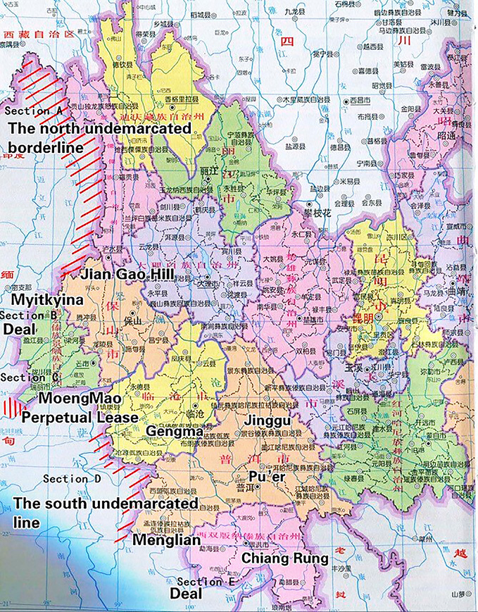
Map 2 is a modern map of Yunnan annotated by the authors with the hatched lines to show the un-demarcated area for precise comparison. The areas in sections A, B, and C are barriers alongside the Tai and Mon-Khmer inhabited areas, while sections D and E show Mengting Prefecture, Cheli Pacification Commission, and Menglian Sub-Pacification Commission. The Qing court began to lose control of these distant places in the early nineteenth century. The areas now belong to the Shan States of Burma, inhabited predominantly by Wa people.
QSL records on 14 Month 12th Guangxu Year 10 (January 29, 1885):
“諭軍機大臣等,曾紀澤電奏,緬甸王昏國亂。有華人據八募城。……儻系亂民。似宜招降該華人。因拓雲南界。據通海之江。以固幸而防患。拓界事,亦宜早商英廷等語。”
[The emperor issues a decree to] the military subjects: “Zeng Jize presented a memorial by telegraph”: The Burmese king is fatuous, and his country is plunged into chaos. There are some Chinese immigrants having taken possession of Bhamo city. . . . If [they] are conspirators, it seems better to pacify these Chinese, therefore Yunnan’s border [should] expand, to reach the [Salween] river which flows into the ocean, so that an advance border would be created. It is better to negotiate with Britain the issue of border expansion at an early date. (QSL, GX 10/12/14, 54, 837 a-b)
Nevertheless, the Qing court refused this suggestion and instead advocated a more cautious approach:
“又諭,電寄曾紀澤來電已悉。朝廷不勤遠略。豈有派兵拓界之事。……如英部談及此事。即本此意酬答。電檔”
[The emperor issues a decree again]: To telegraph Zeng Jize: [His] telegraphy is already known [to me]. [Our] court has never made any effort to strategize for the affairs of distant [countries]. (Note: This means that an invasion was never on the agenda of the Imperial Court.) Isn’t it therefore preposterous to dispatch [our] army for the sole sake of broadening [our] territory? . . . If the British department refers to this matter, reply in accord to the court’s intention. Telegraph. (QSL, GX 10/12/14, 54, 838 a)
A few months later, on 14 Month 9th Guangxu Year 11 (October 21, 1885), Zeng petitioned again, advocating a more offensive stance concerning a westward expansion of the borderline:
“英久占南緬。今圖其北,防法取也。……取八幕,據怒江上遊以通商,勿使英人近我界。”
The British have occupied southern Burma for a long time. Now [they] conspire to get Burma’s [Burma] north, to prevent the area from being seized by France. . . . [We should] take Bhamo and establish a station on the upper reaches of the Nu River (Salween River) to conduct trade. Do not allow the British to come close to our border. . . . (Wang et al. 1987, Vol. 61, 16)
Later, Cen Yuying (1829–89), who was the governor of both Yunnan and Guizhou Provinces in 1873–75 and 1881–89, issued a memorial on 4 Month 5th Guangxu Year 12 (June 5, 1886):
“四月初二日,緬甸稔祚土司等派來阿麻己,發生弄等十人投遞緬字稟函,詢稱英人詐取緬都,緬民失所,懇乞代奏天朝,發兵救援,或簡派大臣前往英國調處,俾存緬祀。……如萬不能自存,只有各率子女來歸,乞為中國編氓等語。譯驗來文相符。……。”
On April 2, the tusi in Renzuo area of Burma sent ten representatives, including A Mayi and Fa Shengnong, to submit a petition letter written in Burmese. Upon inquiry, [they] claimed the British had taken the capital of Burma unrighteously. The Burmese were displaced. [They] beg [me] to draw up a memorial for the Heaven court to send troops to rescue [them] or send ministers to mediate with Britain; to [help them] sustain the Burmese King’s lineage. . . . If [they] cannot save their country, [they] would lead their people to submit to [us]. They beg to be Chinese citizens. [I] have checked [their] statement which corresponds with their Burmese petition. . . . (Huang and Bai [punctuated] [2005], 368)
From these Chinese intelligence communications, it is clear that despite the defeat of their military, the Burmese population at large still resented the British occupation. Widespread resistance to British rule was a definite possibility. The Chinese authorities were thus prompted to consider expanding their sphere of influence in Burma to push the British back as far south as possible. One month later, on 4 Month 6th Guangxu Year 12 (July 5, 1886), Cen Yuying wrote another memorial:
“……據總兵丁槐,道員吳其楨稟稱:四月二十三日,關外木邦土司鐘文源由猛卯前來求見。據稱該土司曾屬中華,淪陷於緬,所管四十九猛,每猛煙戶二三千家,按戶挑派壯丁,可得眾萬余,緬國無主,決計來投,如蒙中華收恤,自當效力邊陲等語。……臣查英人占踞緬都,民心未服,其勢驟難安輯。木邦為緬甸東路咽喉,與滇境遮放土司連界,前明為羈康土府,又改宣慰使司,後為緬甸所滅。國朝乾隆三十一年,其頭目罕宋法舉眾內附,後仍淪入千緬。目下中英和好,若許該土司鐘文源之請,恐啟猜嫌;拒之不納,又慮率眾別投,轉為邊關之患。……伏乞皇太后,皇上聖鑒訓示。謹奏。”
. . . According to the report of the [Tengyue] (today Tengchong, in the southwest part of Yunnan) Zongbing [who was named] Ding Huai (a military officer of the Qing Dynasty: the commanding officer of garrison troops of an area)/Daoyuan [who was named] Wu Qizhen (the administrated officer of the Qing Dynasty, ranking four): on April 23, . . . Mubang tusi (Burmese: Theinni, in the northern part of the Shan States) from outside the border named Zhong Wenyuan who came from Mengmao (Moeng Mao) to beg to see [the leading officials]. [He] claims that [Mubang] was once subordinate to China, [but now] it has fallen into the hands of Burma. [He] rules 49 moeng (müang). Every moeng has 2,000–3,000 households (hu). [They] choose one non-disabled man for each household; thus, they could raise over 10,000 [soldiers]. Now Burma does not have a king [any longer]. [They] decided to be [our] subordinates. If they were granted the chance to be subjects of China, they would serve as guardians of [our] borderline. . . . [I] (Cen Yuying) has confirmed that though the British have occupied the Burmese capital, [they] are resented by the population. It looks like [they] will not be able to pacify the country within a short time. Mubang is a strategic passage in northern Burma. [It] shares a boundary with the Zhefang tusi situated in the territory of Yunnan. [It] was a former Jimi22) aboriginal prefecture in the Ming Dynasty. [Then it] was transformed to be a Pacification Commission. Finally, it was conquered by Burma. In the Qianlong Year 31 (1766), its chieftain Han Songfa led his people to surrender and then integrate into Burma. Now, the Chinese and British have a good relationship. [Thus,] if we heed the request of tusi Zhong Wenyuan, [it will] probably create suspicion. If we reject it, [it is] worrying that [he] may lead his people to surrender to others, which would eventually become a threat to [our] borderline. . . . [I] beg the empress and emperor to instruct [I]. (Huang and Bai [punctuated] [2005], 369–370)
A decree on the conscription of the ministers of the council of state (Jun ji da chen 軍機大臣) was issued on 3 Month 7th Guangxu Year 12 (August 2, 1886):
“諭軍機大臣等,岑毓英奏,稔祚土司請發兵救援壹摺。……茲據該督奏,木邦土司,呈請內附等語。……前稔祚請發兵。今木邦請內附。所謂鋌而走險。叛服無常。……現已飭總理各國事務衙門,與英使訂立新約。斷無為壹二土司,另生枝節之理。……嗣後緬人再有籲請如上項情事。……諭以中英和好有年。不肯輕開邊釁。……該土司等勿得瀆陳。撫以善言。羈糜弗絕。總之……。固不宜顯示拒絕。亦不可輕議招懷。”
Cen Yujing issued a memorial (to the emperor) about the Renzuo tusi’s call for rescue by [our] troops. . . . The governor (Cen Yuying) petitioned that the Mubang tusi was asking to be (our) subordinate. . . . The Renzuo [tusi] previously asked for military support; now, Mubang is asking to be [our] subordinate. They are treading a dangerous path out of desperation. [They] sway between rebellion and subordination. . . . Now, [I] have issued a decree to the Ministry of Foreign Affairs to conclude a new treaty with the British envoys; there is absolutely no reason to raise conflicts just because of one or two tusi. . . . If any Burmese come to appeal for the same issue in the future . . . refer to decree: “The Chinese and British have retained a good relationship for years, [we] are unwilling to spark any frontier disputes.” . . . These tusi should not appeal to [us] again. Pacify [them] with kind words and the Jimi will not cease. All in all . . . it is of course not appropriate to display apparent rejection nor is it to discuss subordination. (QSL, GX 12/7/3, 55, 99a–b)
Earlier, in 1884, Chen Jinzhong (a Siamese consular officer of Chinese ancestry in Singapore) advised the Chinese deputy Zheng Guanying in Singapore on June 14, 1884 (Guangxu Year 10):
“緬亡,則中國雲南恐不可收拾矣。君為中國官,當熟籌而深計也。”
If Burma perishes [because of the British], Yunnan will be plunged into turmoil that will be hard to deal with. As a Chinese officer, you should consider [all possibilities] thoroughly and devise appropriate tactics. (Xia 1982, 977)
It was not in Siam’s interest to let Britain continue to expand its colony. Chen even warned Zheng that after seizing Upper Burma, the British would quickly enter Yunnan and inland China. As a Siamese consular officer, Chen was aware of Great Britain’s territorial ambitions toward Burma and southwest Yunnan, which would trigger a boundary crisis. However, the Qing court stood firm on its traditional diplomatic strategy.
To sum up, the Qing court did not pay much attention to the affairs of these distant areas, whose primary purpose was deemed nothing more than guarding the hinterland. The Qing court even passed up on a great chance to expand the border by taking Bhamo and the Shan States. According to Zhu’s study, if the Qing court had taken advantage of protecting some Chinese immigrants in Bhamo in 1884–85, the British would have let it. That was because General Adamson Major had received an order that he should not take Bhamo if it were already occupied by the Chinese (Zhu 2007, 65). Although some Qing officers took a proactive stance, the court remained reluctant.
It was not long until the traditional diplomatic strategy was challenged by the growing presence of Western colonial powers. After its defeat in the Sino-French War (December 1883 to April 1885), the Qing court gradually realized the severity of the southwest frontier issues when China was forced to abandon its tributary relations with all of Vietnam in 1885. Without the tributary areas as buffers, there was no way to prevent the French from entering China via Tonkin in present-day northern Vietnam. That is why the Qing court insisted that Burma should continue to pay tribute. It intended to keep the tributary relationship to save face and maintain the southwest border as before. Neither Cen’s nor Zeng’s proposals could persuade the court to change its mind.
The Disputed Areas
Why did Zeng fail to come to terms with the British Foreign Office before resigning from his duty and going back to China on 19 Month 3rd Guangxu Year 12 (April 20, 1886)? His suggestions never made their way into the Burma Terms proclaimed on July 24, 1886. The first reason was that the Qing court was not concerned about the ruler being Burmese or British as long as Burma paid tribute every 10 years, a stipulation that the British felt uneasy with (Wang et al. 1987, Vol. 62, 45). This condition cost the Qing court the best opportunity to negotiate with Britain (Zhu 2007, 51–62). The second reason was that Zeng had mistaken the Nu River (Salween River) for the Lu River (Irrawaddy River). The Ministry of Foreign Affairs of the Qing Dynasty ordered him to correct this mistake before negotiating with Britain again (Wang et al. 1987, Vol. 64, 18). At that time, the Qing court’s priority was to deal with the Yunnan-Vietnam frontier issue instead.
Later, when Xue Fucheng became the new Chinese minister in London (1890–94), he resumed the responsibility to negotiate with the British, who already had full control over Burma. He also aimed to understand the situation in Burma during the previous six years. Following his memoirs, we can trace China’s territorial ambitions. Xue was an educated intellectual who knew clearly that the Yunnan-Burma frontier issue would endanger the hinterland if the British kept expanding their influence in southwest China. On 25 Month 1st Guangxu Year 17 (March 5, 1891), he wrote a memorial suggesting that the emperor pursue the demarcation of the Yunnan-Burma frontier in cooperation with the British. Furthermore, he highlighted the benefits China would reap after settling the border issue with Britain (Xue 1894, Vol. 1, 73):
“英人所稱原讓潞東之地,……果能將南掌與拈人收為屬國,或列為甌脫之地,誠系綏邊保小之良圖。……臣閱外洋最新圖說,似老撾已歸屬暹羅。若徒受英人之虛惠,終不能實有其地……宜先查明南掌入暹羅之外,是否尚有自立之國,以定受與不受。”
The British claimed [they] could offer [us] the east bank of the Lu River . . . if we could take Nan Zhang (Lan Sang, notably the northern parts of present-day Laos) and the Shan [State] as [our] subordinate or let it be [our] frontier, [then we are in] a good position to pacify the minorities and guard [our] border. . . . I have seen the latest Western map; it seems that Laos had been ceded to Siam. If we merely accept this faux offering from the British, it does not mean we can genuinely control these territories. . . . [We] should investigate whether any polities in Laos remained independent instead of succumbing to Siam. [Only then can we] decide whether to accept [the British offer] or not. (Xue 1894, Vol. 1, 73)
“其向附緬甸之拈人,地實大於南掌,稍能自立,且素服中國之化。若收為我屬,則普洱,順寧等府邊僥皆可鞏固矣。至曾紀澤所索八募之地,雖為英人所不肯舍,其曾經默許之舊八募者,亦可為通至大金沙江張本。若將來竟不與爭,或爭而不得,竊有五慮焉。夫天下事不進則退。從前展拓邊界之論,非謂足增中國之大也。臣聞乾隆年間,緬甸恃強不靖,吞滅滇邊諸土司,騰越八關之外,形勢不全。西南壹隅,本多不甚清晰之界,若我不求展出,彼或反將勘入。壹慮也。我不於邊外稍留餘地,彼必築鐵路直接滇邊,壹遇有事,動受要挾。二慮也。長江上源為小金沙江,最上之源由藏入滇,距邊甚近,洋圖即謂之揚子江。我若進分大金沙江之利,尚可使彼離邊稍遠。萬壹能守故界,則彼窺知江源伊邇,或浸圖行船,徑入長江以爭通商之利。三慮也。夫英人經營商埠,是其長技。我稍展界,則通商在緬甸,設關收稅,亦可與之俱旺。我不展界,則通商在滇境,將來彼且來擇租界,設領事,地方諸務不能不受其牽制。四慮也。……既入滇境,窺知礦產之富,或且漸生狡謀。五慮也。……既而英人不認允曾紀澤三端之說,謂普洱外邊南掌,拈人諸地,及大金沙江為公用之江,與八募設關也。”
The Shan States that was subordinated to Burma has a territory larger than that of Laos. It is somehow autonomous and does not give in to China’s pacification. (Note: it is thus more Sinicized than Laos.) If we take the Shan States, then the border of Pu’er Prefecture and Shun Ning Prefecture would be reinforced. As for the Bhamo area that Zeng Jize asked for, although the British did not want to release it, they did give their tacit approval for [us to take the] old Bhamo area (Kokang, in the Shan State23)), which leads to Da Jinsha Jiang (Irrawaddy River). If we do not fight for these areas in the future, or if we fight and fail, five concerns will arise. Under any circumstances, a person loses if he cannot gain. The discussion on border expansion was not done to enlarge the territory of China. I have heard that Burma leveraged its military strength and could not be pacified during the Qianlong Period; it annexed various regions near the border headed by rulers in Yunnan. [We have no idea about] the situation in Tengyue on the outer side of the eight barriers. The border at the southwest corner [of Yunnan] has always been unclear. If we do not seek expansion, we might let them (Britain) invade [us]. This is the first concern. If we do not leave a bit of a buffer, they will certainly construct a railway that leads to the Yunnan border. Whatever happens, our action would be limited. This is the second concern. The upper Chang Jiang River (Yangtze River) originates from the small Jin Sha Jiang (Jinsha River). The source lies in Tibet, and the river runs toward Yunnan, which is close to [our] border. Western maps call it the Yangzi River. If we expand to take the Da Jinsha Jiang (Irrawaddy River), we can still keep them (Britain) slightly away from our border. If we stand still on our current border, they will notice that the river source is close. [They] might try to [induce] overflow to sailboats into the Chang Jiang River to strive for commercial profits. This is the third concern. The British are good at running commercial ports. If we expand [our] border, then the business will be conducted in Burma. We can set up a customs point and collect tax in Burma to prosper together [with the British]. If we do not expand, then the business will be conducted in Yunnan. If they request to set up a concession, or consulate [in Yunnan], it will be hard for local affairs not to be affected. This is the fourth concern. . . . Once they enter Yunnan, [they will] learn of Yunnan’s rich mineral resources, which might bring out their devious side. This is the fifth concern. . . . The British did not agree to Zeng’s proposal of making Nan Zhang (the northern parts of present-day Laos), the Shan States, and Da Jinsha Jiang (Irrawaddy River) designated public areas for both buffer zones and making Bhamo a customs station. (QSG, 1977, Vol. 48, 14686-14687 [Vol. 528 Biography 315 Subordinate States 3: Burma, Siam, Nan Zhang (Laos), Su Lu (Saltanah Sulu)])
Xue made it clear that the British offer of Nanzhang (present-day northern Laos) and Shan States (present-day northeast Burma) to the Qing court did not carry much weight, as the areas were controlled by Siam and Burma, not the British. He pointed out that the frontier in the southwest region had always been unclear. If the Qing court did not seek to expand, the territory would be taken, and the situation might get out of control. The Qing court would then be put in an awkward position. In his memorial, Xue strongly suggested that the Qing court actively engages in negotiations with the British. At the same time, investigators were sent to scout the borderline according to Xue’s suggestion. The goal was to persuade local rulers in the area to defend the Qing court and keep the Western colonial powers away from the hinterland. Therefore, Xue suggested making Bhamo a customs point to collect taxes and open up the Irrawaddy River for public use (mainly for the Qing court). According to Zhu’s study and Xue’s journal, it is clear that the Qing court merely wanted to extend its frontier to include the buffer areas. It is also evident that Xue intended to garner more leverage to bargain with the British. He knew that it was impossible to ask the British to follow the agreed arrangements that Zeng had proposed six years earlier as the British had already taken control over Upper Burma. Thus, he wanted to demand more concessions to gain the upper hand in the negotiation (Xue 1985, 585; Zhu 2007, 70–74).
On July 10, 1892, Xue was sent to negotiate with the British Foreign Office on the Yunnan-Burma frontier and a trade agreement. The negotiations did not go smoothly, according to two of Xue’s journal entries of 27 Month 7th Guangxu Year 19 (September 7, 1893). The first one is titled Memorial of the Summary of the Demarcation on the Yunnan-Burma Frontier (Dianmian fenjie dagai qingxing shu: 滇緬分界大概情形疏):
“英人自翻前議,雖以公法為解,實亦時勢使然。……前歲英兵遊弋滇邊,以查界為名,闌入界內。……曾紀澤曾照會外部,請以大金沙江為界,江東之境,均歸滇屬,英人堅拒不納。……臣相機理論,稍就範圍,……據稱已與印督商定於孟定橄欖壩西南邊外讓我壹地曰科幹,在南丁河與潞河中間,蓋即孟根土司舊壤,計七百五十英方裏。又自孟卯土司邊外包括漢龍關在內,作壹直線,東抵潞江麻栗壩之對岸止,悉劃歸中國,約計八百英方裏。又有車裏,孟連土司,轄境甚廣,向隸雲南版圖,近有新設鎮邊壹廳,系從孟連屬境分出。英人以兩土司昔嘗入貢於緬,並此壹廳爭為兩屬,今亦原以全權讓我,訂定約章,永不過問。……”
Britain repudiated the previous agreement (with Zeng). Although the British explained [the repudiation] on the basis of the international treaty (the Burma Terms), the true reason is that the situation has changed. . . . Last year the British army patrolled along the border of Yunnan to investigate the border and violated our territory. . . . Zeng Jize once proposed to the British Foreign Office to make Da Jinsha Jiang (Irrawaddy River) the border, with the territories on the east bank put under the control of Yunnan. But the British refused. . . . I waited for a suitable time to raise our arguments for territorial expansion. . . . [Britain] allegedly had agreed with the Indian governor to make Mengding and southwest Ganlanba, namely Kokang, a Chinese concession, which is located between the Salween River and the Nan Ding River with a total acreage of 750 square miles. Then draw a straight line from the border of Meng Mao, including (the customs point of) Han Long Guan (now in Burma), eastward until the Salween River and Mali Ba (today the capital of Kokang)—the area will be ceded to China, about 800 square miles. Then there are Cheli and Menglian, which is a large area that has always belonged to Yunnan. [We] recently have established a new prefecture, derived from Menglian, for the pacification of the border. The British [however] leveraged the fact that Menglian and Cheli had paid tribute to Burma to ask to make these shared territories. Nevertheless, now they agreed to let us have full sovereignty via a treaty and will not raise any questions on it again. (Xue 1894, Vol. 2, 22)
There are three main points raised in the above text: first, Zeng’s previous proposal was rejected by the British; second, Xue highly recommended to the Qing court to expand the territory; third, Britain recognized the full sovereignty of the Qing court over Cheli and Menglian. Xue supplemented this first memorial with a second titled Memorial of Taking Back of the Full Sovereignty of Cheli and Menglian (Shouhui Cheli, Menglian liang tusi quanquan pian: 收回車裡,孟連兩土司全權片):
“再滇屬東南,羈縻之境,以車裏,孟連兩土司為最大。近年,新設鎮邊直隸廳,撫理孟連北境,計此壹廳,兩土司之地約可抵內省四五府。當臣與英廷爭論野人山地之時,英外部以車裏,孟連曾經入貢緬甸,亦堅索兩土司及新設壹廳,作為兩屬,以相抵制。臣查會典及壹統輿圖,車裏,孟連隸滇已久,鎮邊新設直隸廳同知壹官,若忽改為兩屬,尤屬無此體制,不得不盡力堅持。厥後,外部遂自轉圈,願以全權仍歸中國。果使撫馭得宜,固守封域,可以支格英法暹羅三國之窺伺,而臨安,普洱,思茅,元江諸府廳州當皆恃以無虞。不意英事甫定,法謀又起,近來法人迫脅暹羅割其湄江東岸之地,而車裏轄境之大半亦在湄江以東。法人疊次以分界為請。雖據稱並無侵佔滇地之意,彼知英人饒舌於先,未必不思效尤於後。然英究僅有索問之空言,並未獲絲毫之實利。臣今正與英廷互商條約,聲明車裏全屬中國與英毫無幹涉。約章壹定不吝借英助我作證。法人素性畏強侮弱。彼聞中國與俄爭帕米爾,與英爭野人山皆不遺餘力,倘竟知難而退,僅請分化界限,以杜爭端,則和平互商自易辦理,不茲口舌,不起風波,尤善之善者也,理合附片具陳伏乞,聖鑒謹奏。”
In the southeast of Yunnan, in the Jimi areas, the two biggest tusi are Cheli and Menglian. In recent years, a new prefecture named Zhen Bian was established to pacify the northern border of Menglian. There is only this one prefecture. The areas of Cheli and Menglian are equal to four or five sub-prefectures in the hinterland. When the British officials and I debated on Yeren Mountain (Kachin Hills), the British Foreign Office leveraged the fact that Cheli and Menglian had paid tribute to Burma to claim control. They wanted to establish a new prefecture and designate it and the two tusi to be shared territories. I have looked up the Huidian (Code of the Great Qing Dynasty) and Yitong Yutu (Atlas of the Qing Dynasty): Cheli and Menglian have been parts of Yunnan for a long time. The new prefecture has just been established and its officer appointed. If we made these areas shared territories all of a sudden, there was no administrative system to put in place, so we stood firm on our stance. A moment later, the British Foreign Office convinced themselves to let China have full sovereignty over Cheli and Menglian. If [we] pacify and control [them] (Cheli and Menglian) suitably, [they will] guard [our] borderline and prevent spies from Britain, France, and Siam. Moreover, Lin’an and Pu’er, Simao and Yuanjiang Prefectures, could then be stabilized. Unfortunately, as soon as issues with the British have been settled, here come the French. Recently the French have forced Siam to cede the east bank of the Mekong River, and most parts of Cheli are situated there. The French requested several times to demarcate the border with us. Although they claim to have no intention to occupy Yunnan, if they know about the talk by the British, there is no guarantee that they will not follow suit. The British currently have only asked about it with empty words; they have not gained any real benefits. Now, I am negotiating the treaty with the British, claiming Cheli and Menglian belong solely to China and have nothing to do with the British. Once the treaty is signed, [I] will go as far as asking the British to be our witness to prove [that Cheli and Menglian are part of China]. The French always fear the powerful and prey on the weak. When they hear about how we spared no effort in fighting against the Russians for Pamir and the British for Yeren Mountain (Kachin Hills), it is hoped that they will proceed with the negotiation of demarcation peacefully with no arguments. Then the issue can be easily resolved without much drama. Here is my memorial, your Majesty. (Xue 1975, 22–23)
As Warry suggested in his report, the idea of ceding Chiang Rung (Cheli) might have been firmly rejected by the Qing court. Thus, he asked the British government to handle the issue with great caution. Moreover, Chiang Rung also could be a buffer area since the French had already taken Tonkin.24) That is why when Xue demanded full sovereignty over Cheli and Menglian, the British did not object. However, the British were afraid that the French would annex Chiang Rung and Moeng Laem. The condition was then written into the clause: the Qing court was not allowed to cede Chiang Rung and Moeng Laem to a third country. This clause caused a series of problems, which will be discussed later.
Taking back Menglian and Cheli was a remarkable achievement of Xue’s diplomatic career. He was praised by the Qing court. His efforts were, however, criticized by a number of scholars in the twentieth century as many believed Menglian and Cheli had been an inherent territory of China. However, now, many agree with Xue’s point of view. Although Cheli and Menglian had paid tribute to the Qing court for a long time, the areas were far from the hinterland and hard to defend and control. Xue tried his best to bargain with the British and persuaded them to recognize China’s full sovereignty over Cheli and Menglian. With the eastern borderline among China, Burma, and Laos clarified, the area became more organized, and fewer disputes occurred. Furthermore, Britain and France then had a “buffer.” A balance of powers was achieved, with Xue as the pivotal figure.
In a nutshell, Zeng proposed the following: (1) expanding the Chinese border to include the Nan Zhang (Lan Sang)25) and the Shan States, which were located outside Pu’er Prefecture; (2) designating Da Jinsha Jiang (Irrawaddy River) as a public area available to both sides for trade; and (3) establishing a Chinese customs point near Bamo (Bhamo) to collect taxes.
While his three suggestions sounded reasonable, Zeng’s downfall came about because he mistook the Irrawaddy River for the Nu River when it was the Salween River. The Qing Ministry of Foreign Affairs (Zong li ya men 總理衙門) lost its faith in Zeng as he did not seem to know enough about Yunnan. He was ordered to be extra careful before reaching a final decision with the British Foreign Office. Today, only a few records on this matter can be found in the British envoy’s office. The envoy remarked that the three suggestions were not acceptable and thus could not be part of the Burma Terms. The Qing court missed the opportunity to make the best deal.
Zeng’s successor Xue knew it was not possible to continue pursuing Zeng’s suggestions. He then tried his best to come up with the following demands: (1) make Irrawaddy River (Salween River) the border, with Yunnan taking the areas east of the river; (2) cede Kegan (Kokang), an area of about 800 square miles in the territory of Menggen (Moeng Khuen, i.e., Chiang Tung), to China; (3) let part of Yeren Shan (Kachin Hills) be included in the western border of Yunnan;26) (4) recognize Chinese sovereignty over Cheli (Sipsòng Panna) and Menglian (Moeng Laem); (5) send Burmese officers to pay tribute to China regularly, and (6) let China establish a customs point in Bhamo to collect taxes. In exchange, the Qing court would give up Chiang Tung and Mupang (Map 3).27)
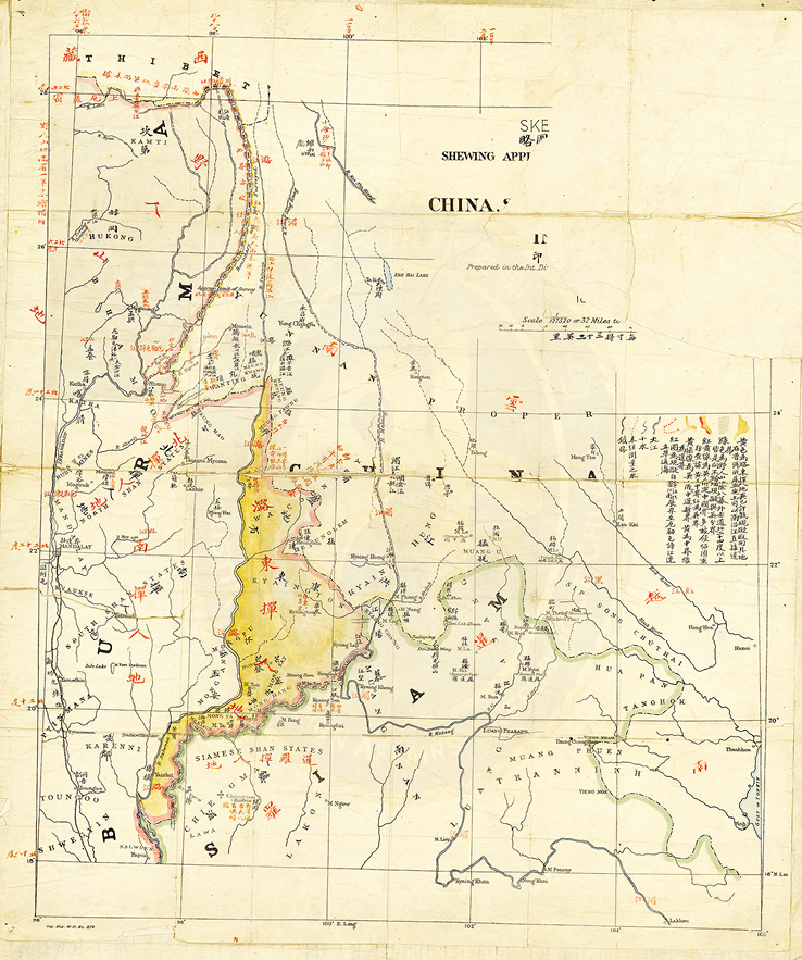
Map 3 Map of the Yunnan-Burma-Siam Border
Source: National Palace Museum of Taipei, Treaties and Maps That Defined the Qing’s Southwest Boundaries, Exhibition Room North Yard Gallery 104.
British Reaction
According to the Warry Report
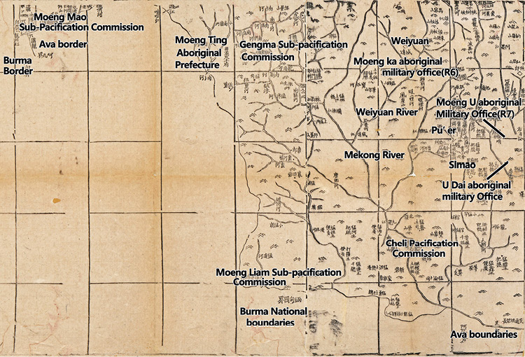
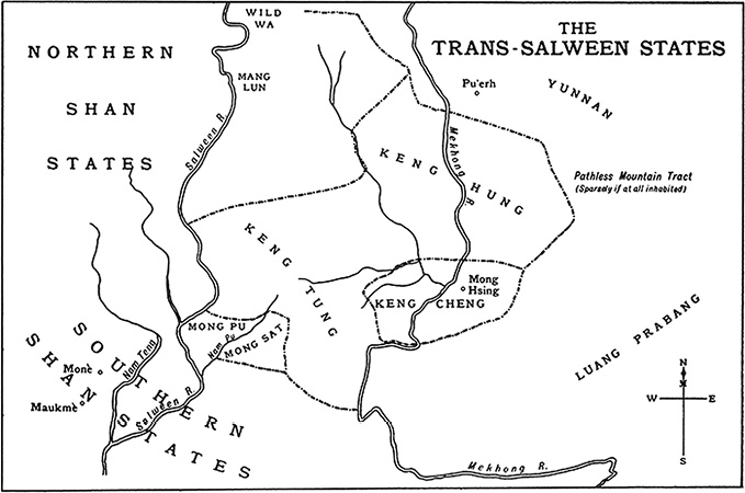
With the Qing court’s stance made clear, we now compare it with Britain’s stance, which can be traced through the reports of Scott and Warry, who also drew Maps 4 and 5.
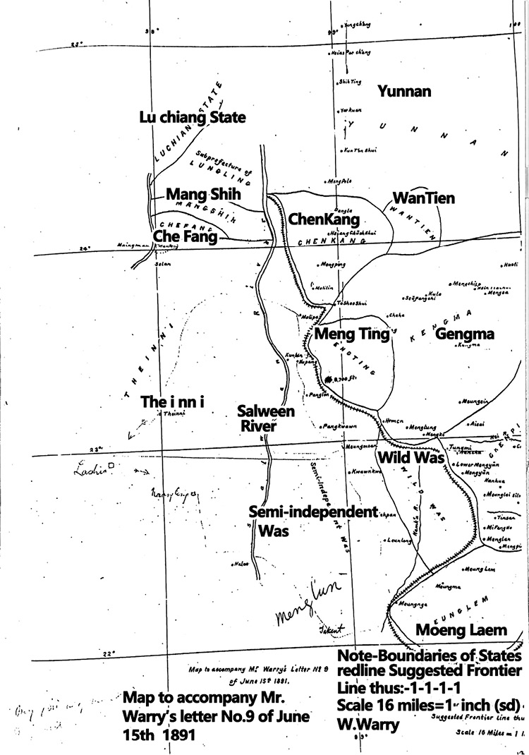
Map 4 Map Accompanying Warry’s Letter No. 9 of June 15, 1891
Source: From W. Warry, Esq., Political Officer, to the Chief Secretary to the Chief Commissioner, Burma, -No. 9, dated Bhamo, the 15th June 1891.
Map 5 Map Accompanying Warry’s Letter No. 9 of June 15, 1891
Source: From W. Warry, Esq., Political Officer, to the Chief Secretary to the Chief Commissioner, Burma, -No. 9, dated Bhamo, the 15th June 1891.
We begin with an extract from Warry’s report:
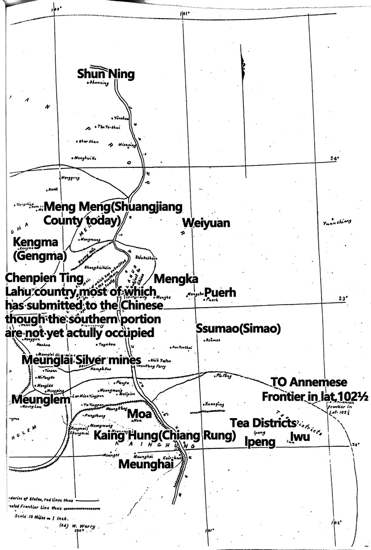
First, on the Trans-Salween section (Map 6) of the Bhamo-Chinese frontier of the 13 Trans-Salween Shan States, three only, namely, Mainglingyi, Kiangtung, and Kianghung have a frontier facing that of Yunnan. Before proceeding to trace the boundary line it will be useful to give a short account of the relations of these three States to China.
(1) Mainglingyi (Menglian in Mandarin and Moeng Laem in Tai): Mainglingyi has been influencing by China since nineteenth century. . . . This small Shan district, usually called Myenlyin, which lies a march or two to south-east of Kengma (Gengma). But be this as it may, it is clear that the Chinese have exercised no interference whatever the affairs of Mainglingyi for at least a century. On the other hand, Mainglingyi has in recent times often been under the authority of Kiangtung when Kiangtung paid tribute to Burma; the present Sawbwa (Tai: Chaofa, literally “Lord of Heaven”) of Mainglingyi was appointed by King Mindon, and this State may be properly classed among Burmese dependencies.
(2) Kiangtung (Jingdong in Mandarin, Chiang Tung in Tai): This State was undoubtedly tributary to Burma. Its Chiefs were appointed by Burma, and in troublous times the Burmese Kings held a military come at its capital.
(3) Kianghung (Jinghong in Mandarin, Chiang Rung in Tai): It is in respect of Kianghung that questions are most likely to arise when the question of delimitation is under discussion. Historically, . . . troops from Burma or Kiangtung have occasionally invaded western Kianghung and compelled a temporary recognition of Burmese suzerainty; and that on one occasion at least (1878) a Sawbwa of Kianghung was nominated by Burma . . ., from 1730 onwards for many years Kianghung was under the direct administration of the Chinese Prefect at Pu-erh. In more recent times Kianghung has been practically independent. . . . Its Sawbwas hold a high-sounding Chinese title the institution of which dates from the year 1387 A.D.; they refer important questions to the Ssu-mao (Simao) official from arbitration; and according to Mr. Bourne, who visited Ssu-mao in the winter of 1885, they still suffer the Chinese Sub-prefect at that place to exercise a concurrent jurisdiction over the eastern portions of their State. (Note by W. Warry, Esq., Political Officer, Bhamo, on the Trans-Salween section of the Burmo-Chinese frontier, dated Mandalay, the 20th September 1888)
According to both Chinese records and Warry’s report, it is certain that Moeng Laem, Chiang Tung, and Chiang Rung paid tribute to Burma. Chiang Tung was even occupied by the Burmese several times. Warry also mentioned that Chiang Rung benefited from the Chinese allegiance through support against Burmese or Siamese invasion. As Foon Ming Liew-Herres et al. (2012, 49) points out, Moeng Laem and Chiang Rung were influenced by China and Burma for centuries: the “Chinese-Burmese condominiums were established since the sixteenth century and prevailed until the late nineteenth century.” That is expressed in the Tai metaphor ฮ่อเป็นพ่อ เมียงเป็นแม่ (Hò pen pò man pen mae: The Chinese [Hò] are [our] father, the Burmese [man] are [our] mother). Imperial China was uneasy about allowing its vassal states to pay tribute to Burma. However, when the Burmese influence increased while the influence of the Qing court was still limited in this area, the imperial Chinese court had to make a compromise with Burma and the frontier polities (Liew-Herres et al. 2012, 49–56). This historical background must be taken into consideration when it comes to demarcation issues.
Warry’s colleague Lieutenant H. Daly further reveals:
In both Meung Lem and Kaing Hung the expression “China is our father and Burma our mother” is a stock diplomatic phrase, and it appears certain that for a considerable period prior to King Mindon’s death no Chief of either State was regarded as duly and finally installed until he had been confirmed in his position by both Burma and China.
So far as I am aware there are no reasons for advocating the inclusion within our limits of any of the Border States which owe undivided allegiance to China. (Warry’s report: From Lieutenant H. Daly, Superintendent, Northern Shan States, to the Chief Secretary to the Chief Commissioner, Burma, -No. 6F., dated Bombay, the 12th June 1891)
Speaking about the Chinese influence in this region, Warry mentions that the rubber trade in the north of Kamaing28) was run mainly by Chinese or Burmese agents of Chinese (From W. Warry, Esq., Political Officer, to the Chief Secretary to the Chief Commissioner, Burma, No. 15, dated Shwegu, the 18th May 1890). He was worried that was not only the rubber trade business influenced by the Chinese, but also considerable areas in the Shan States acknowledged the suzerainty of China:
These districts owning allegiance were termed under the Chinese Ming dynasty the San Fu (三府) or Three Prefectures, and under the present Chinese dynasty. (From W. Warry, Esq., Political Officer, Mandalay, to the Chief Secretary to the Chief Commissioner, Burma, No. 11, dated the 15th July 1888) (Fig. 1 and Map 7)
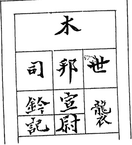
Fig. 1 世襲木邦宣慰司鈴記 [The hereditary wood seal of Mubang Pacification Commission. Some seals issued by the present Chinese dynasty are still hidden away in Upper Burma.]
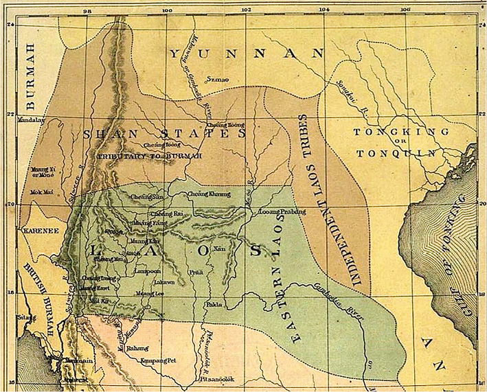
Map 7 Nineteenth-Century Map, Including the Chinese Shan States
Source: “The Shan States,” Wikiwand.
However, he was also aware of the dwindling Chinese influence after the Qing-Burma wars at the end of the eighteenth century. In the end, the Mubang districts were absorbed into the Burmese kingdom, and the Chinese influence dwindled.
In considerable detail, Warry describes how China tried to pacify these recalcitrant Shan States:
For the last eight or nine years, however, the Chinese have devoted much more attention to their frontier dependencies, and all the Sawbwas (Chaofa, “Lord of Heaven”) now complain that they cannot raise enough money to meet the demands made upon them. Nowadays a Chinese official expects handsome presents from all Sawbwas in his charge when he takes up his appointment, when he visits the State when any cases connected with it come before him. The exactions of military officials are even more oppressive and capricious. For instance, the Kangai Sawbwa, who is the proud possess[or] of a long black beard kept carefully wrapped up in a silk bag, told me last year that this ornament had cost him tales 2000. He went on to explain that this was the sum which General Ting had fined him for having presumed to wear a beard when paying an official visit, this being held to be a disrespectful action in a subordinate. No wonder that the old Sawbwa desired incorporation with Yunnan, when such tyranny would no longer be possible, or that, failing this, he longed for the old times, when the States were free from Chinese inference. Not very long ago Mengmao and Chefang were at war for several years; many lives were lost, much property was destroyed, and general disorganization prevailed. “Why did you not step in and stop the fighting?” I asked the Deputy P’eng when he was travelling with me last year. He hesitated a moment, and then said “Well, to speak the truth, our officials never heard a word about it.”
Warry first reminded the Chinese would actively resist the British government that attempts to claim any part of Chiang Rung on the farther bank of the Mekong. He highlighted that this extension of territory would bring the British into direct conjunction with the frontier in Tongquin (Tonkin), the borders of which were thought to match with those of eastern Kianghung (Note by W. Warry, Esq., Political Officer, Bhamo, on the Trans-Salween section of the Burmo-Chinese frontier, dated Mandalay, the 20th September 1888). Nevertheless, he suggested ceding Moeng Laem as it paid tribute to Burma as Chiang Rung did. Second, he said Kiangtung (Chiang Tung) was undoubtedly tributary to Burma, and Burmese appointed its chiefs. Burmese military forces guarded its capital on many occasions.
Historically, Chiang Rung paid tribute to both Burma and China. Warry addressed the issue of Chiang Rung, which was most likely to arise during delimitation. In more recent times Chiang Rung was practically independent, despite having a strong leaning toward China (Note by W. Warry, Esq., Political Officer, Bhamo, on the Trans-Salween section of the Burmo-Chinese frontier, dated Mandalay, the 20th September 1888). Liew-Herres et al. (2012, 55) point out those Tai polities “had the advantage of playing the ‘father’ (China) and the ‘mother’ (Burma) against each other and of gaining a maximum of autonomy.” In some cases, the “father” and “mother” could come to an agreement. In 1838 both sides reached an agreement to force these Tai polities—Chiang Rung, Chiang Tung, and Moeng Laem—to accept a peace convention (Liew-Herres et al. 2012). In a traditional patriarchal family, the father is deemed superior to the mother. Therefore, as the “father,” the Chinese spoke louder than the Burmese.
Reports from Other British Missions
Besides Warry’s report, we can trace the British frontier strategy through a number of missions sent during the 1860s to 1890s to investigate the border between Upper Burma and southwest Yunnan. The other British missions were deployed to open up a practical and direct commercial route. Since the mid-nineteenth century, the British Chamber of Commerce had urged the British government to investigate Upper Burma and western Yunnan as soon as possible. Memorials No. 32 and 33 stated the following:
No. 32 . . . the third from the Halifax Chamber of Commerce, dated 30 August 1866, and addressed to the . . . Chancellor of the Exchequer, and the other Lords of the Treasury; thus concluded:—The British government to “take all necessary measures for a survey of the country between Rangoon and Kiang-Hung (Chiang Rung, namely Sipsong Panna), with a view to the opening of a practical and direct commercial route to Western China.”
No. 33 . . . the second from the Bradford Chamber of Commerce, dated 30 November 1866, and addressed to the Earl of Derby, K.G., First Lord of the Treasury; thus concluded:—That your Lordship’s will please forthwith to authorise and direct a proper official survey, by a competent civil engineer of this country, of the best route for railway communication from Rangoon, via Kiang-Tung and Kiang-Hung, to the south-western provinces of China. (Tracts Vol. 606, Direct Commerce with the Shan States and West of China, by Railway from Rangoon to Kiang-Hung, on the Upper Kamboja River, on the South-west Frontier of China. Memorial No. 48 Thereon. From the Wakefield Chamber of Commerce. To the Lords of her majesty’s treasury, 15th of November 1868, London: 1869 [Parliamentary Paper, “Rangoon & Western China,” 28, A. Sess. 1866, Pa. 12 and 14])
After emerging victorious in the Sino-French War, France conquered the north and central Vietnam, leaving the British wondering whether the French would get ahead in exploiting the benefits from the commercial competition in mainland Southeast Asia and China. The reporter “R.G.” pressed the British government not to wait, otherwise “the Frenchman would make a way to China for us” (Tracts Vol. 606. Overland Communication with western China. A brief statement of how the matter stands at present by R.G. with a map. Liverpool: Webb, Hunt & Ridings, 9, Castle Street. Overland communication with China. The Chambers of Liverpool and Manchester).
Later, on July 23, 1882, Cameron was stopped at Seumao (Simao, today Pu’er Prefecture) because the local authorities refused to issue him a permit to pass through Kiang Hung.29) Meanwhile, the other mission, led by Colquhoun and Wahad, yielded fruitful results. The men departed from Canton (now Guangdong) on February 5, 1882, and went through Pe-se (today Baise, Guangxi Province) to South Yunnan through Kwang-nan (Guangnan), Linan (Lin’an), and Puerh (Ning’er County today) to Sao-mao (Simao). However, they had to depart from Simao to Dali, because Chiang Rung was in an unstable situation (Tracts Vol. 606, Overland China Mail, March 7, 1882; Times of India, August 8, 1882). Following are excerpts from Colquhoun’s record:
. . . [We] traversed the whole of South Yun-nan by . . . Puerh to Ssu-mao, the last south-western military and administrative centre of the Chinese Government in Yun-nan. . . . From Ssu-mao it was intended to pass through the Laos countries, either east or west of the Mekong to Zimme or Xieng-mai (the northernmost Siamese Laos state), and thence to South-Eastern Burmah. . . . The neighbouring state of Xieng-hong was in a disturbed condition, and civil war reigned there owing to a question of succession. . . . Mr. Colquhoun did not consider it prudent to enter the Xieng-hong territory. . . . I-bang is a Laos district tributary to China, situated seven stages south-east of Ssu-mao, and supplies most of the so-called Puerh tea; hence it is a Laos and not a China tea.
From the above reports, it seems evident that before the third Anglo-Burmese War British missions were sent with a primary interest in opening a practical commercial route. The purpose of the following missions then switched to surveying the borderline in order to get more benefits from the frontier negotiation. Warry’s and Scott’s missions then visited the northern Shan States and the Burma-Yunnan boundary successively from 1889 to 1904.30)
Tracts Vol. 727 (Diary of Events of Military Interest in Burma for January 1894 Bhamo and the North) recorded the following: “Captain Davies was after all permitted to accompany Mr Warry to Manwaing. On January 8th (1894) Mr Warry, accompanied by Captain Davies and with a small escort of a corporal and four men of the Yorkshire Regiment, left Namkham with the Chinese officials.” We can see that Warry accompanied Scott on his mission after he had finished his mission in 1889. Together they made a record of the Chinese military forts and the attitude of Chinese officers toward foreigners. It is reported that the viceroy of Yunnan (Songfan 崧蕃 [1895–1900]) was very amicable and favourably inclined toward the British. Warry and Scott also investigated the military posts in the Chinese territory. This was a clever manoeuvre on the part of the British government to get as much useful information as possible before signing the treaty on March 1, 1894. Unlike imperial China, Britain was savvy at frontier negotiations, with plenty of experience under its belt. Thus, China found itself in a passive position in the borderline negotiation during the 1890s.
The Reaction of Moeng Laem and Chiang Tung during the Late 1890s
The border negotiations between Britain and China should have left some traces in the collective memory of the Tai ethnic groups living on both sides of the border between British Burma and the Chinese province of Yunnan. One might, in particular, expect some reflections on these negotiations in the indigenous historiography of Moeng Laem and Chiang Tung, the two Tai polities most severely affected by the border agreement. The Chiang Khaeng Chronicle, composed in 1905, gives much prominence to the Anglo-French border treaty of 1896, which led to the division of the small Tai Lue principality of Chiang Khaeng (with its capital at present-day Müang Sing) along the course of the Mekong River. The chronicle describes in detail the strategies employed by the local elites to prevent this border treaty as well as the local reactions to the final disintegration of the Chiang Khaeng polity (Grabowsky and Renoo 2008, 43–46).
Looking at the various extant versions of the Moeng Laem Chronicle, transmitted on mulberry paper manuscripts by Pò Saeng Sam, a prolific scribe from Moeng Laem with connections to the former ruler’s court, we found no mention of the Anglo-Chinese border negotiations of the 1890s. For the second half of the nineteenth century, the Moeng Laem Chronicle deals with the conflicts between the lowland Tai and the intrusions of the Lahu (Musoe) hill tribe since the 1840s, which caused considerable political and social unrest in this small Tai polity. In the 1880s Moeng Laem was threatened by military intervention from Chiang Tung (soek khoen), which aimed at enforcing the extradition of a prince from Chiang Rung to Chiang Tung (in 1882), and by the fighting between Moeng Laem’s ally Chiang Rung with its rebellious district (panna) of Moeng Cae (in 1888). Nowhere is Britain mentioned as a political player affecting the security of the local Tai polity in Moeng Laem.
The historiography of Chiang Tung, however, provides a different picture. The Jengtung (Chiang Tung) State Chronicle (CTSC), translated and edited by Sāimöng Mangrāi (1981), pays a great deal of attention to the British victory over Burma in 1885. The defeat of Burma is described with a certain amount of satisfaction as it brought Chiang Tung some relief from Burmese military pressure, which had increased over the previous year. The British conquest of Upper Burma created a temporary power vacuum in the Shan areas, which enabled Chiang Tung to establish itself as a de facto independent polity during 1885–90 and expand its political influence deep into areas on the west bank of the Salween River. This situation abruptly ended in 1890, when “the Gāla Ingalik entered the state,” as the CTSC states in a very brief entry for the year CS 1252 (AD 1890/91). Though the British now considered Chiang Tung a protectorate, the CTSC gives the impression of Chiang Tung as an autonomous though small kingdom, as is reflected by the ostentatious Sanskrit-derived title of Prince Kònkaeo, who ascended to the throne of the Tai Khuen polity in 1896. In early 1899 the boundary between China and the British protectorate of Chiang Tung was settled. The chronicle describes these negotiations in a way that gives the Chiang Tung ruler and his officials’ disproportionate prominence as part of the British delegation:
In the year 1260, Month Three (Dec. 1898/Jan. 1899) the prince, accompanying the commissioner [of Burma], went out to demarcate the boundary with China. On the Chinese side there were Taudhāy, as the head, and Denpīn. [The boundary line] began from the Namhlak, Hlabhuk, along the boundary of Möngphaen, Möngyāng, to Dā-āng, down to Latīp, going out to Bānnôy, Kāngbengnāng, Moengva, Jengkhāng, Bānjhô, Bānfāy, Mönghlōy, along the Namṅa until the Mekong was reached. On the British side there were the commissioner and the prince heading the officials; on the Chinese side there were Taudhāy and the Prince of Svaenhvīfā heading the officials, and they went to have a conference at Mönglōng [a substate of Jengtung]. When that had been done the prince returned to Jengtung City during Month Eight of the year 1261 (May/June 1899). (Sāimöng Mangrāi 1981, 277)
It is evident here that the Tai Khuen elites of Chiang Tung did not consider the Anglo-Chinese boundary demarcation of 1899 to be detrimental to their interests. The fact that local rulers and their high-ranking officials were allowed to become part of the British delegation refurbished the rulers’ image as local actors in the borderlands of upper mainland Southeast Asia.
The Final Treaty
There were no objections from either China or Britain against Mupang (Theinni), Moeng Khuen (Chiang Tung), and Manmo (Bhamo) being absorbed into British Burma. The controversial parts in the frontier negotiation remained the territories of Yeren Mountain (Kachin Hills, in Mengyang, namely Kachin State), Menglian, Cheli, and Kokang, and access to the upper Irrawaddy River.
On 20 Month 12th Guangxu Year 19 (January 26, 1894), Xue presented the final proposal (Map 8): China would cede territories east of the Irrawaddy River in exchange for expansion on the original frontier of an extra 20 miles. The northern section of the frontier would be temporarily demarcated, except Cheli and Menglian would become a definite part of Chinese soil. A straight line would be drawn from Moeng Mao (Namkam) to Maliba (Kokang), with the east and north sides belonging to China (Xue 1975, 5).
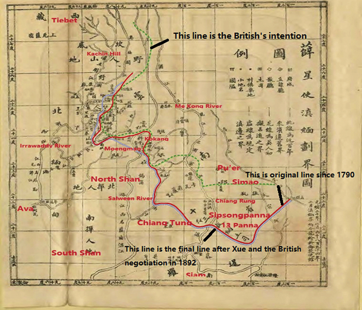
Map 8 This Atlas was the Final Demarcation Report in Xue Fucheng’s Memorial in 1894.
Source: Xue (1975, 5).
Instead of 20 miles, Britain agreed to an expansion of only 5 miles. Additionally, a clause forbidding Menglian and Cheli from being ceded to a third party was demanded by France. The Resumption Treaty of China-Britain on Yunnan-Burma’s Border and Trade in Services of the Clauses (中英續議滇緬界務商務條款) was finally signed on 24 Month 1st Guangxu Year 20 (March 1, 1894) in London. There were 20 clauses in this treaty. As a Chinese record notes:
“二十年正月,訂滇緬新約十九條,劃定自尖高山起,向西南行至江洪抵湄江之界線,大金沙江許中國任便行船,刪去八募設關壹條。於是緬事粗結。”
[Guangxu] In the Year 20 (1894), in the first month of the lunar year, [we are] formulating a new Dian-Mian (Yunnan and Burma) treaty. This new treaty has a total of 19 [sic] stipulations. [The new border] is designated to reach Jian Gao Mountain (Teng Chong) in the north. In the southwest, the border runs from Jianghong (Chiang Rung, south of Sipsong Panna) to Mei Jiang (Mekong River). It allows Chinese ships to sail in the Irrawaddy River at any time, but the issue of establishing a customs station in Bhamo is deleted. Thus, the borderline issue between Yunnan and British Burma is roughly resolved. (QSG 1977, Vol. 48, 14689 [Vol. 528 Biography 315 Subordinate States 3: Burma, Siam, Nan Zhang (Laos), Su Lu (Saltanah Sulu)])
The treaty defined the middle and southern frontiers of Yunnan-Burma, but the north was defined as an undetermined frontier. The territories of Sipsong Panna, Menglian, and Mengding were demarcated. Thus, the first stage of the Yunnan-Burma frontier issues was concluded.
Xue did an excellent job for China’s interests. This treaty not only kept Cheli and Menglian within China but also slightly expanded the southwest territory. Nonetheless, Zhang (1937), Liu (1946), and Yu Dingbang (2000) point out that Xue failed to negotiate over the loss of many territories, such as Bhamo, Mupang, and Chiang Tung. In contrast, Zhu (2004) holds that Xue tried his best to hold onto the southwest territories by taking back Cheli and Menglian, keeping Kokang (old Bhamo), and expanding the southwest territory of Yunnan. For the British, it was a successful treaty as it gave them what they wanted. The English version of the “1894 Convention between Britain and China” illustrated the frontier (Map 9), which perfectly corresponded with the Chinese version:
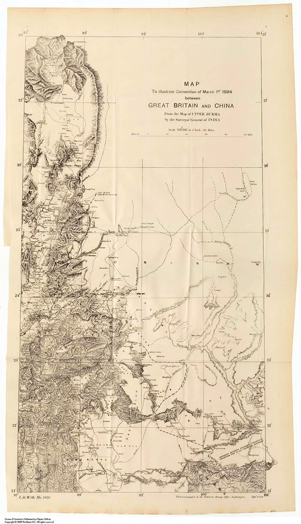
. . . leaving to China the State of Kokang . . . and Meng Ting which belongs to China. . . . It will still continue to follow the frontier between those two districts, which is locally well known . . . and will then follow the line of water-parting between the tributaries of the Salween and the Mekong Rivers . . . leaving to China the Tsawbwaships (lordships) of Keng Ma, Mengtung, and Mengko . . . leaving Munglem to China, and Manglün to Britain. It will then follow the boundary between Munglem and Kiang Hong, which is locally well known; It will then follow the boundary between Kiang Tong and Kiang Hung. . . . His Majesty the Emperor of China shall not, without previously coming to an agreement with Her Britannic Majesty, cede either Munglem or Kiang Hung, or any portion thereof, to any other nation. (Treaty Series, No. 19, 1894, 4–7)
Map 2 shows that of sections A, B, C, D, and E, only sections B and E were settled, with a clause in section E determining that Cheli and Menglian could not be ceded to a third country. Section C (Moeng Mao) became a perpetual lease area, and sections A and D were un-demarcated areas.
Evaluation of the Clause
The authors believe that Zhu (2004) made an objective assessment. Even if China had obtained more territory in this treaty, it would not have been able to guard it as the country was too weak at that time. China lost the Sino-Japanese War in 1894–95, marking the failure of the Westernization Movement (Yang wu yun dong 洋務運動). China was deemed as an old, weak, and frangible nation that any powerful country could get a piece of. Moreover, Mupang, Bhamo, and Chiang Tung had already been subordinated to Burma for over a century, with little Chinese influence left in these areas. It was therefore not practical to ask for the return of these areas.
Its defeat in the Sino-Japanese War compelled China to cede Moeng Vu (U) and U De (U-Tai) to France in 1897 (Map 10). That was because earlier, on April 17, 1895, after the Treaty of Shimonoseki was signed between China and Japan, France managed to force Japan to return the province of Liaoning (northeast China) to China and then demanded that one of the 12 panna, Moeng Vu (U) and U De (U-Tai) in northern Phongsaly in Laos today, be ceded to France as a reward.
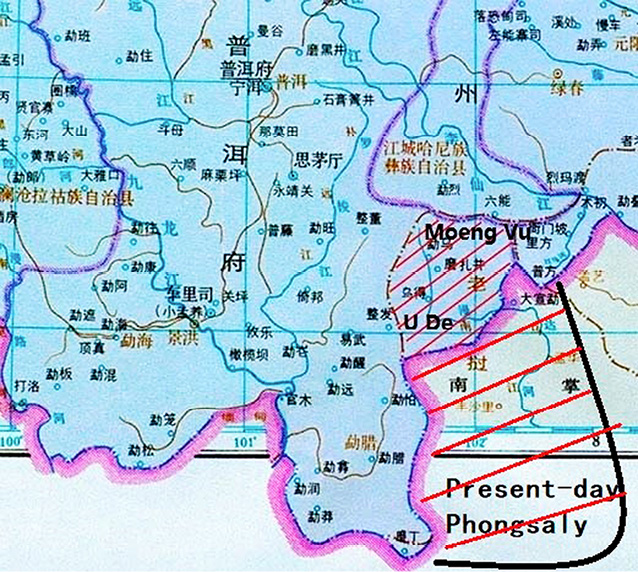
Map 10 Annotated from Tan et al. (1982, Vols. 6, 7, 8)
France’s demand, however, forced China to violate the treaty it had signed with Britain. In order to achieve a beneficial supplemental agreement with China for additional trade benefits, as well as curbing French colonial ambitions in mainland Southeast Asia and the Chinese hinterland, a new mission led by Scott was sent again to Upper Burma and southwest Yunnan. In 1895–96, Scott’s mission submitted another confidential report in which he argued:
We should be only a few miles distant from Puerh and Sumao, two of the most important towns in the south-west corner of Yunnan, and, should the trade of Yunnan fall short of expectations, we should be in a better position and have a better chance of creating a trade, being on the Mekong, than if we limit ourselves to the Kong Ming Shan range. . . . There remains the western part of the province, and whether a great trade will eventually be created there or not, we are running a commercial race with France, the prize being the possession of that trade. If the retention of Mong Lem and Kèng Hung be a commercial advantage to us in the race, then let us keep these provinces. . . . France regards Yunnan as the “natural Hinterland” to her Tonkin possessions, and she will sooner or later make a bid for a further advance northwards. Should this ever come to pass and Mong Lem (Meng Lian), Keng Hung (Jing Hong), and Chen Pien (Zhen Bian) remain Chinese territory, there will be a tongue of China between us and the French which, in the event of an alliance between the two powers ever becoming au fait accompli, would bring their forces very close to the Salween. . . . On the Mekong we should be far more favourably situated, for we should then be on the direct flank of the French in the event of any further extension on their part taking place towards the north. (Property of the Government of India. Issued by the Intelligence Branch, Q.M.G.’s Department. This report is transmitted for the personal information of the Chief Secretary Chief Commissioner Burma by direction of His Excellency the Commander-in-Chief in India and is to be considered Confidential. Supplement to Report of the intelligence officer on Tour with the Superintendent, Northern Shan States, 1895–96, 3)
Scott strongly recommended that the British government extend the frontier to include Pu’er (Ninger County, administered by Pu’er Prefecture today) and Sumao (today’s Pu’er Prefecture), which meant annexing Mong Lem (Moeng Laem) and Keng Hung (Jinghong/Chiang Rung), if commercial benefit could be generated. On the other hand, he was worried about sharing a direct border with France. Therefore, this confidential report suggested that the British government carefully consider whether it was worth it to expand its territory toward Pu’er.
The British were also cautious about triggering military conflicts because they believed the Yunnanese probably possess higher fighting qualities than the Chinese who inhabit the sea-board and dwell in the valleys of the great waterways. They are well armed and, if properly led, it is not improbable that they would fight well. (Property of the Government of India. Issued by the Intelligence Branch, Q.M.G.’s Department. This report is transmitted for the personal information of the Chief Secretary Chief Commissioner Burma by direction of His Excellency the Commander-in-Chief in India and is to be considered Confidential. Supplement to Report of the intelligence officer on Tour with the Superintendent, Northern Shan States, 1895–96, 3)
The British government thus hesitated to claim Menglian and Cheli.
Zhu (2007, 99) stresses that the British government insisted on compensation for the breach of the treaty for two reasons: first, Britain felt offended; second, it was afraid that France would take advantage of the commercial and strategic competition in the Upper Mekong Basin and enter the Chinese hinterland via Yunnan. According to the collection of original documents Siam, France, and China. British Documents on Foreign Affairs (Part I, Series E, Vol. 23, 159), Zhu also concludes that Moeng U and U Tai did not mean much to the British (Zhu 2007, 101). She reveals that the British could have asked for less territory in the Yeren Mountain area if they could have opened a commercial port in Xi Jiang (西江), from Yunnan to Guizhou/Guangxi and then Guangdong.
Therefore, when the Qing court refused to cede Cheli and Menglian to the British, the latter did not insist on it. As the Qing Ministry of Foreign Affairs memorialized to the emperor on 15 Month 11th Guangxu Year 21 (December 30, 1895):
“查西江通商雖於厘金有損,尚有洋稅抵補,野入山地則系雲南屏障,且照英外部所索又不止野人山地,竟將包絡西南延及車裏土司壹帶,形勢全失。兩害相形則取其輕,目恐今日遷延不決又將別起波瀾,更難收拾,臣等共同密酌,擬將西江通商允準,而野人山界事仍與實力磋磨。”
[I] have looked into opening a commercial port in Xi Jiang. Although there will be a loss in the lijin (a local business tax that was utilized during the late Qing Dynasty), the customs taxes could offset [the loss]. Yeren Mountain is the barrier of Yunnan. Moreover, the British Foreign Department claimed not only Yeren Mountain but also the southwest [Yunnan], and sought to extend [the border] to Cheli. [Yunnan would] thus lose the [barrier] terrain. The lesser of the two evils should be chosen. Currently, [I] am afraid [if we] delay the decision, things would be unpredictable. It would be even more difficult to deal with. [We] have discussed together secretly, and plan to approve the opening of the commercial port in Xi Jiang, and the frontier of Yeren Mountain will be negotiated [with Britain] with strength. (Wang et al. 1987, Vol. 119, 5)
Finally, the Renewed Burmese Treaty between China and Britain (中英續議緬甸條約) was signed on February 4, 1897. China was willing to give up Kegan (Kokang) and the north of Danni (Theinni, part of Mupang), and the British were allowed to set up a new commercial port in Xi Jiang. This was the last official negotiation between China and Britain, bringing an end to the border dispute.
The two powers had tested each other’s bottom lines to maximize their benefit for the past 10 years. Both sought ways to garner trade benefits amid the demarcation of the Yunnan-Burma boundary. It is hard to say which side won the bargain. Britain had to abandon its territorial claims on Cheli and Menglian, while China also had to abandon some of its historical territories.31)
Besides, China was forced to face an increasingly serious boundary crisis. The Qing court was prompted to retire its traditional diplomatic strategy and embrace being part of the modern world, in which China no longer stood in the centre. It was a hard pill to swallow. That was why many scholars in the early or middle of the twentieth century regarded Xue as an incompetent traitor who sold out on many of China’s historical territories.
Conclusion
William Warry was a British intelligence officer who led a mission to investigate Upper Burma and southwest Yunnan during the years 1889–91. The main purpose of the mission was to obtain knowledge about the situation in these areas, such as ethnic groups, topography, and border issues; and then offer useful insights to the British government on matters such as handling the rubber trade and peacefully expanding business with India, Burma, and China, and ways to negotiate with the Qing court to maximize benefit in the frontier negotiation. Warry also promoted a railway extension from Burma to Yunnan. There is not enough information to gauge to what extent the British government adopted his suggestions, but the government in London did conclude a treaty with the Qing court a few years after the mission. The treaty was to define the border between southwest Yunnan and Burma. On March 1, 1894, both sides signed a treaty with 20 clauses, including those recognizing China’s sole sovereignty over Moeng Laem and Chiang Rung, as part of Cheli, as Warry had suggested.
In the final days of the Qing Dynasty, from the late nineteenth century—when the tributary system had collapsed—the Qing court had to face a serious frontier crisis. This crisis was fueled by the rise of Western colonial powers internationally and the rise of Chinese nationalism domestically. Imperial China had to adjust itself to the rapidly changing world dominated by the West.
Thongchai (1994) suggests that boundary issues were a concern mainly of the British, while the Siamese did not find the existing boundary to be an issue and thus did not feel the need to do anything about it. In this case, Western colonial powers invaded the countries of mainland Southeast Asia, causing several frontier problems. The traditional tributary system, for which some Western scholars coined the concept of Mandala in Southeast Asian polities, was challenged by the new international rules, which were determined by Western colonial powers. China could not avoid being part of the world. After that, most Asian countries had to accept the modern rules formulated by the Western world. By giving up distant, multiethnic areas at the periphery of the empire and at the same time keeping their core areas intact, these Asian countries—such as Siam—were able to survive. As a result of this process, the geo-body of a modern nation-state emerged. States such as China and Siam knew clearly that the multiethnic areas along their borders were difficult to administer and integrate into mainstream society. Sacrificing these less important places and strengthening sovereignty over the Chinese and Thai core areas proved to be a wise strategy for the weaker Asian countries during the colonial period.
The only difference between China and Siam in this regard was that China held onto the idea that it was the centre of the world until the early twentieth century. China was afraid of losing face when it had to negotiate the Yunnan-Burma frontier with Great Britain. That was why it insisted on maintaining its traditional tributary system at the expense of giving up many practical benefits. However, Siamese policy was more flexible and pragmatic. As Rama IV, King Mongkut argued, the most important goal was to save and protect the Siamese Empire and to prevent it from being colonized. His successor, Rama V, or King Chulalongkorn, continued his father’s policy. He ensured that Siam did not get involved in the colonial system of Western imperialist powers. Unfortunately, China did not have a wise ruler of comparative standing in the nineteenth and early twentieth centuries.
The boundary is part of the concept of a nation-state and helps the latter to distinguish itself from other authorities. For local people who lived along the newly drawn borderlines, in many cases, the boundary existed only on a map, not in their minds. Based on geographical proximity, people in the border areas always retained intimate economic or emotional relationships across national borders, especially when they came from the same ethnic group and shared the same language, culture, and even identity.
One such border area was Yuesong (岳宋鄉) in Ximeng County, which was inhabited by members of the Wa (of Mon-Khmer stock) and Tai ethnic groups. The county was located in northwest Menglian on the right bank of the Salween River. The territory of Ximeng bordered the Burmese Wa State, which is marked as section D on Map 2, to the south of the un-demarcated line. On October 1, 1960, the Frontier Convention between China and Burma (中國人民共和國和緬甸聯邦邊界條約) was signed. Through this agreement, the frontier issue between China and Burma, which had lasted for 70 years, was finally resolved. The territory of Ava Mountain was split into two parts: one went to China and the other to Burma.32) Thus, the Wa people became another one of the main transborder ethnic groups. Their national awareness is an interesting case study, which has attracted scholars since the 1960s (Guo 2012, 20–28). Wa people who live on both sides of the border still retain close relationships with one another. In 2008, one of the authors of this paper went to do fieldwork in Yuesong. She interviewed several Wa people from Burma who admitted that they frequently crossed the border to visit their relatives. The borderline marks administrative boundaries but does not serve as a partition wall for groups of the same ethnicity. The Wa people represent a common social phenomenon in southwest Yunnan and probably also mainland Southeast Asia. Yunnan is one of the most complicated areas in China. That was one of the reasons why Warry had to investigate Upper Burma and southwest Yunnan personally.
Between the Burmese territory and inland China, along the upper Mekong River and the Irrawaddy River, multiethnic groups have lived independently for hundreds of years. However, the rise of British colonial ambitions and China’s growing awareness of frontiers changed the destiny for these multiethnic, distant areas.
The borderlines were formed after fierce negotiations between China and Britain. This demarcation defined most of the areas caught in the border dispute between Yunnan and British Burma. For Britain, the demarcation of borderlines was a successful expansion into the Indochinese Peninsula; for China, it was a big challenge to its century-old diplomatic strategy in dealing with “barbarian polities” at its southern periphery; for local polities, it was a life-changing event that was decided for them without much of their involvement. The truth is that preferential diplomacy would never be offered to a weak state.
Accepted: July 4, 2019
References
Primary Sources:
1. Chinese
Chen Xiafei 陳霞飛, ed. 1995. Zhongguo haiguan midang: Hede, Jin Denggan handian huibian 1874–1907, juan ba 中國海關密檔:赫德,金登幹函電彙編 1874–1907, Volume 8 [Confidential archives of Chinese customs: Compilation of Letters and Telegrams from Sir Robert Hart and James Duncan Campbell 1874–1907, Vol. 8]. Beijing: Zhonghua Shuju.
―, ed. 1991. Zhongguo haiguan midang: Hede, Jin Denggan handian huibian, juan si 1874–1907 中國海關密檔:赫德,金登幹函電彙編 1874–1907, Volume 4 [Confidential archives of Chinese customs: Compilation of Letters and Telegrams from Sir Robert Hart and James Duncan Campbell 1874–1907, Vol. 4]. Beijing: Zhonghua Shuju.
Dao Yongming 刀永明. 1989. Zhongguo Daizu shiliao jiyao 中國傣族史料輯要 [The historical data summary of Chinese Tai]. Kunming: Yunnan Minzuchubanshe.
Fang Guoyu 方國瑜. 1987. Zhongguo xinan lishi dili kaoshi 中國西南歷史地理考釋 [Historical geography textual research of southwest China]. Beijing: Zhonghua Shuju.
Guangxu. 1885. Zeng Jize handian huibian 曾紀澤函電彙編 [Collections of Zeng Jize’s telegrams], Chinese Archives of the Grand Council/Telegrams, 20, Month 10, Guangxu 11 years [September 13]. Beijing: Preserved by the First Historical Archives Office of China.
Huang Zhennan 黃鎮南; and Bai Yaotian 白耀天 (punctuated). 2005. Cen Yuying wenji 岑毓英文集 [The collections of Cen Yuying]. Nanning: Guangxi Minzuchubanshe.
Li Genyuan 李根源, ed. Annotated by Lu Weixian 陸衛先 and Yang Wenhu 楊文虎. 2001. Yongchang fu wenzheng juan er 永昌府文征卷2 [The Wenzheng of Yongchang Prefecture, Vol. 2]. Kunming: Yunnan Meishuchubanshe.
Photocopy. 1986. Qing shi lu 清實錄 [Veritable records of the Qing Dynasty (Vols. 1–60)], Vol. 54/55. Beijing: Zhonghua Shuju.
Tan Qixiang 譚其驤 (chief editor) et al. 1982. Zhongguo lishi ditu ji 中國歷史地圖集 [Historical atlas of China], Vols. 6, 7, 8. Shanghai: Cehui Chubanshe.
Wang Yanwei 王彥威 et al., ed. 1987. Qingji waijiao shiliao 清季外交史料 [Historical data of diplomacy during the Qing Dynasty]. Beijing: Shumu Wenxianchubanshe.
Xia Dongyuan 夏東元, ed. 1982. Zheng Guanying ji juan yi 鄭觀應集卷1 [Collections of Zheng Guanying, Vol. 1]. Shanghai: Shanghai Renminchubanshe.
Xingqiu Map, ed. 2009. Yunnansheng ditu 雲南省地圖 [Yunnan Provincial Map]. Beijing: Xingqiu Dituchubanshe.
Xue Fucheng 薛福成. 1985. Chushi Ying/Fa/Yi/Bi siguo riji 出使英法意比四國日記 [Journal of the mission on Britain/France/Italy/Belgium]. Changsha: Yuelu Chubanshe.
―, comp. 1975. Dianmian huajie tushuo 滇緬劃界圖說 [Illustrated handbook of demarcation between Yunnan and Burma]. Taipei: Chengwen Chubanshe.
―. 1894. Chushi zoushu 出使奏疏 [Memorial of diplomatic mission], published by Xue during the Jiawu year of the Guangxu Emperor reign.
Yao Wendong 姚文棟. 1892. Yunnan kanjie choubian ji 雲南勘界籌邊記 [Boundary survey and building the border of Yunnan]. Chengdu: Zunjing Shuyuan.
Yin Lun 尹倫; Tang Li 唐立; and Zheng Jing 鄭靜. 2010. Zhongguo Yunnan Menglian daiwen guji bianmu 中國雲南孟連傣文古籍編目 [A synopsis of old Dai manuscripts in Menglian County of Yunnan, China]. Kunming: Yunnan Minzuchubanshe.
Yin Mingde 尹明德. 1933. Zhongying bianjie jiaosheshi [A]. Yunnan biandi wenti yanjiu (shangjuan) [C] 中英邊界交涉史 [A]. 雲南邊地問題研究 (上卷) [C] [Negotiation history of China and the British on the boundary (A) Boundary study of Yunnan, Vol. 1 (C)]. Kunming: Yunnan Shengli Kunhua Minzhong Jiaoyuguan.
Zhao Erxun 趙爾巽 et al., ed. 1977. Qing shi gao 清史稿 [Draft of the history of the Qing Dynasty (Vols. 1–48)], Vol. 48, pp. 14686–14687 and 14689. Beijing: Zhonghua Shuju.
2. English
Ainslie, Clement. 1893. Report on a Tour through the Trans-Salween Shan States: Season 1892–93. Rangoon: Superintendent, Government Printing, Burma.
Appendix to Memorandum on Questions of Chief Importance in the American and Chinese Department, British Documents on Foreign Affairs, Part I, Series E, Vol. 23.
British and Foreign State Papers [1885–1886], Vol. 77, 123.
Dai Yingcong. 2004. A Disguised Defeat: The Myanmar Campaign of the Qing Dynasty. Modern Asian Studies 38(1): 145–189.
Extract from Report on the Sino-Burmese Frontier, British Documents on Foreign Affairs, Part 1, and Series E, Vol. 23.
Grabowsky, Volker; and Renoo Wichasin. 2008. Chronicles of Chiang Khaeng: A Tai Lü Principality of the Upper Mekong. Honolulu: Center for Southeast Asian Studies, University of Hawai‘i.
Harvey, G. E. 1925. History of Burma: From the Earliest Times to 10 March 1824. London: Frank Cass.
Legge, James D. D., LLD, trans. 1939. Chinese Classics: A Translation, Critical, and Exegetical Notes, Prolegomena, and Copious Indexes. London: Oxford University Press.
Liew-Herres, Foon Ming; Grabowsky, Volker; and Renoo Wichasin. 2012. Chronicles of Sipsong Panna: History and Society of a Tai Lue Kingdom Twelfth to Twentieth Century. Chiang Mai: Mekong Press.
Maring, Joel M.; and Maring, Ester G. 1973. Historical and Cultural Dictionary of Burma. New Jersey: The Scarecrow Press.
Photocopies of Selected Official and Private Papers of William Warry (1854–1936), acting assistant Chinese secretary, Peking 1881–82, special service, Government of India from 1885, political officer, Bhamo, Mandalay and Shwegu 1887–89, adviser to the Chief Commissioner, Burma, on Chinese affairs 1890–1904; including photocopies of maps of the Trans-Salween section of the Burmo-Chinese frontier by Warry. Mss Eur Photo Eur 384 (1878–1903), preserved in India Office Records Diaries held by the European Manuscript Section.
Note by W. Warry, Esq., Political Officer, Bhamo, on the Burmo [Burma]-Chinese Boundary, dated the 14th May 1888.
From W. Warry, Esq., Political Officer, Mandalay, to the Chief Secretary to the Chief Commissioner, Burma, No. 11, dated the 15th July 1888.
Note by W. Warry, Esq., Political Officer, Bhamo, on the Trans-Salween section of the Burmo-Chinese frontier, dated Mandalay, the 20th September 1888.
From W. Warry, Esq., Political Officer, to the Chief Secretary to the Chief Commissioner, Burma, No. 15, dated Shwegu, the 18th May 1890.
From Lieutenant H. Daly, Superintendent, Northern Shan States, to the Chief Secretary to the Chief Commissioner, Burma, -No. 6F., dated Bombay, the 12th June 1891.
From W. Warry, Esq., Political Officer, to the Chief Secretary to the Chief Commissioner, Burma, -No. 9, dated Bhamo, the 15th June 1891.
Sadan, Mandy. 2008. A Guide to Colonial Sources on Burma: Ethnic & Minority Histories of Burma in the India Office Records, British Library. Bangkok: Orchid Press.
Sao Sāimöng Mangrāi. 1965. The Shan States and the British Annexation. Ithaca Southeast Asia Program, Dept. of Asian Studies, Cornell University.
―. 1981. The Pādæng Chronicle and the Jengtung State Chronicle Translated. Ann Arbor: Center for South and Southeast Asian Studies, University of Michigan.
Supplement to Report of the intelligence officer on Tour with the Superintendent, Northern Shan States, 1895–96, 3
Thongchai Winichakul. 1994. Siam Mapped: A History of the Geo–Body of a Nation. Honolulu: University of Hawai‘i Press.
Tracts Vol. 606, under the catalogue: Colquhoun Expedition into Burmah. Opinions of the Press, London, 1882; under the correspondent: Overland China Mail, March 7th, 1882 (pp. 7–8) and “Times of India,” August 8th, 1882 (pp. 21–23).
Tracts Vol. 606, The “Times,” September 12th, 1882.
Tracts Vol. 606, Direct Commerce with the Shan States and West of China, by Railway from Rangoon to Kiang-Hung, on the Upper Kamboja River, on the South-west Frontier of China. Memorial No. 48 Thereon. From the Wakefield Chamber of Commerce. To the Lords of her majesty’s treasury, 15th of November 1868, London: 1869 [Parliamentary Paper, “Rangoon & Western China,” 28, A. Sess. 1866, Pa. 12 and 14.
Tracts Vol. 606. Overland Communication with western China. A brief statement of how the matter stands at present by R. G. with a map. Liverpool: Webb, Hunt & Ridings, 9, Castle Street. Overland communication with China. The Chambers of Liverpool and Manchester.
Tracts Vol. 727, Diary of Events of Military Interest in Burma for January 1894 Bhamo and the North.
Treaty Series. No. 19. 1894 Convention between Britain and China, Article III of the Convention of July 24, 1886, Relative to Burmah and Thibet [Tibet]. Signed at London, March 1, 1894. Ratifications exchanged at London, August 23, 1894. London: Printed for her Majesty’s Stationery Office, by Harrison and Sons, St. Martins Lane. House of Commons Parliamentary Papers Online. Copyright 2005 ProQuest Information and Learning Company.
Books and Articles:
1. Chinese
Feng Yue 馮越; and Qi Pengfei 齊鵬飛. 2006. Zhongmian bianjie tanpan shulue 中緬邊界談判述略 [A brief study of the Sino-Burma frontier negotiations and amendment of several related historic facts]. Journal of Hunan University of Science Technology (Social Science Edition) 9(6): 55–60.
Guo Yue 郭銳. 2012. Zhongmian waren guojia yishi jiangou de lishi xushi 中緬佤人國家意識建構的歷史敘事 [Historical narrative of the national awareness between China and Burma]. World Ethno-National Studies 1: 20–28.
Hamashita Takeshi 濱下武志. Zhu Yingui 朱蔭貴, trans. 1999. Jindai Zhongguo de guoji qiji: Chaogong maoyi tixi yu jindai yazhou jingji quan 近代中國的國際契機―朝貢貿易體系與近代亞洲經濟圈 [International opportunity of modern China: The tributary trade system and the economic circle of modern Asia]. Beijing: Zhongguo Shehuikexue Chubanshe.
Liu Bokui 劉伯奎. 1946. Zhongmian jiewu wenti 中緬界務問題 [The Sino-Burmese boundary problem]. Shanghai: Zhengzhong Chubanshe.
Lü Yiran 呂一燃. 1995. Xue Fucheng yu Zhongying dianmian jiewu jiaoshe薛福成與中英滇緬界務交涉 [Negotiation between Xue Fucheng and boundary issues of China and Britain]. China’s Borderland History and Geography Studies 2: 57–72.
Peng Jianying 彭建英. 2004. Zhongguo chuantong jimi zhengce luelun 中國傳統羈縻政策略論 [On the evolution of the traditional mollification of the Chinese ancient central dynasties for minorities]. Journal of Northwest University (Philosophy and Social Sciences Edition) 34(1): 104–108.
Yu Dingbang 餘定邦. 2000. Zhongmian guanxi shi 中緬關係史 [China-Burma relationship history]. Beijing: Guangmingribao Chubanshe.
Zhang Chengsun 張誠孫. 1937. Zhongying Dianmian jiangjie wenti 中英滇緬疆界問題 [Dian-Burmese boundary issues of China and Britain]. Beijing: Hafu Yanjingxueshe.
Zhang Zijian 張子建. 2007. Xue Fucheng zai Zhongying <Xuyi Dianmianjie shangwu tiaokuan> Zhong dui beiduanjie de huafen 薛福成在中英<續議滇緬界・商務條款>中對北段界的劃分 [Xue Fucheng’s demarcation on the north boundary in the China-Britain clause: <Resumption treaty of China and Britain on the Yunnan-Burma border and trade in services of the clauses>]. Journal of Yunnan National University (Social Science) 1(1): 108–118.
Zhu Shaohua 朱昭華. 2007. Zhongmian bianjie wenti yanjiu: Yi jindai Zhongying bianjie tanpan wei zhongxin 中緬邊界問題研究―以近代中英邊界談判為中心 [Studies of China-Burma borderland issues: Centering on the Chinese-British borderland negotiation during modern times]. Ha Erbin: Heilong Jiang Jiaoyuchubanshe.
―. 2004. Xue Fucheng yu Dianmian bianjie tanpan zai yanjiu 薛福成與滇緬邊界談判再研究 [A reappraisal of Xue Fucheng and the negotiations of the boundary of China’s Yunnan Province and Burma]. China’s Borderland History and Geography Studies 14(1): 43–51.
2. English
Crosthwaite, C. E. 1912. The Pacification of Burma. London: Frank Cass. Reprinted in 1968 by Frank Cass.
Giersch, C. Pat. 2006. Asian Borderlands: The Transformation of Qing China’s Yunnan Frontier. Cambridge: Harvard University Press.
Goldston, Desley; and Stuart-Fox, Martin, comp. 2019. Engaging Asia: Essays on Laos and Beyond in Honour of Martin Stuart-Fox. Copenhagen: NIAS Press.
Grabowsky, Volker. 2006. Die Gemeinwesen der Tai in Yunnan und ihre Tributbeziehungen mit China [The polities of the Tai in Yunnan and their tribute relations with China]. In Han-Zeit: Festschrift fur Hans Stumpfeldt aus Anlass seines 65. Geburtstages [Han time: commemorative for Hans Stumpfeldt on the occasion of his 65th birthday], edited by Michael Friedrich and Reinhard Emmerich, pp. 573–593. Lun Wen: Studien zur Geistesgeschichte und Literatur in China 8 [Studies on intellectual history and literature in China 8]. Wiesbaden: Harrassowitz Verlag.
Higgins, Roland L. 1992. The Tributary System. In Pacific Century: The Emergence of a Modern Pacific Asia, edited by Mark Borthwick et al., p. 30. Boulder: Westview Press.
Horstmann, Alexander; and Wadley, Reed L., eds. 2006. Centering the Margin: Agency and Narrative in Southeast Asian Borderlands. New York and Oxford: Berghahn Books.
Hughes, Richard W. 1999. Burma’s Jade Mines: An Annotated Occidental History. Journal of Geo- literary Society 14(1): 15–35.
Li Yi. 2016. Governing the Chinese in Multi-ethnic Colonial Burma between the 1890s and 1920s. South East Asia Research 24(1): 135–154.
Liew-Herres, Foon Ming. 1996. Luchuan-Pingmian Campaigns (1436–1449) in the Light of Official Chinese Historiography. Oriens Extremus 39(2): 162–203.
Liew-Herres, Foon Ming; and Grabowsky, Volker. 2008. Lan Na in Chinese Historiography: Sino–Tai Relations as Reflected in the Yuan and Ming Sources (13th to 17th Centuries). Bangkok: Institute of Asian Studies, Chulalongkorn University.
Ma Jianxiong. 2014. The Rise of Gentry Power on the China–Burma Frontier since the 1870s: The Case of the Peng Family in Mianning, Southwest Yunnan. International Journal of Asian Studies 11(1): 25–51.
Michaud, Jean. 1999. Handling Mountain Minorities in China, Vietnam and Laos: From History to Current Concerns. Asian Ethnicity 10(1): 25–49.
Mitton, G. E., ed. 1936. Scott of the Shan Hills: Orders and Impressions. London: Butler & Tanner Ltd.
Mote, Frederick W. 1999. Imperial China 900–1800. Cambridge: Harvard University Press.
Nish, I.; Partridge, M.; Watt, D. Cameron; and Bourne, K., eds. 1989/1995. British Documents on Foreign Affairs: Reports and Papers from the Foreign Office Confidential Print. Frederick: University Publications of America.
Perdue, Peter C. 2015. The Tenacious Tributary System. Journal of Contemporary China 24(96): 1002–1014.
“Shan States.” n.d. Wikiwand. http://www.wikiwand.com/en/Shan_States, accessed September 2, 2019.
Stuart-Fox, Martin. 1998. The Lao Kingdom of Lān Xāng: Rise and Decline. Bangkok: White Lotus.
Syatauw, J. J. G. 1961. Some Newly Established Asian States and the Development of International Law. The Hague: Martinus Nijhoff.
Unger, Jonathan. 1997. Not Quite Han: The Ethnic Minorities of China’s Southwest. Bulletin of Concerned Asian Scholars 29(3): 67–76.
Wade, Geoff, ed. 2015. Asian Expansions: The Historical Experiences of Polity Expansion in Asia. Abingdon and New York: Routledge.
Walker, Andrew, ed. 2009. Tai Lands and Thailand: Community and State in Southeast Asia. Copenhagen: Nordic Institute of Asian Studies.
1) The full name of this confidential document kept in the British Library is: “Photocopies of Selected Official and Private Papers of William Warry (1854–1936), acting assistant Chinese secretary, Peking 1881–82, special service, Government of India from 1885, political officer, Bhamo, Mandalay and Shwegu 1887–89, adviser to the Chief Commissioner, Burma, on Chinese affairs 1890–1904; including photocopies of maps of the Trans-Salween section of the Burmo-Chinese frontier.” For the sake of convenience, this article will refer to this document as “Warry’s report” in an abbreviated form.
2) Previously known as the Oriental and India Office Library, or the British Library: Asia, Pacific and African Collections (APAC).
3) The Shan States were under the jurisdiction of the colonial power, namely Great Britain. Moreover, “the single Shan State within the Union of Burma, including the former Wa States, was formed in 1948.” For more details see Maring and Maring (1973, 223–224). Therefore, the term of Shan States will preferably be used in this article, because this term relates to the administrative and political context during the time of British jurisdiction. However, the footnote 23 is an exception, as Kokang is now part of the Shan State of present-day Burma.
4) The British National Archives have a description of Warry in the catalogue Photocopies of Selected Official and Private Papers of William Warry (1854–1936), https://discovery.nationalarchives.gov.uk/details/r/76ae707b-3a1c-4323-b5b3-1dd5a956b58f, accessed August 4, 2019.
5) All 18 dynasties in the history of the Chinese Empire may be regarded as the imperial court or Chinese Empire. In this article, the authors use “Qing court” to refer specifically to the last dynasty in the history of the Chinese Empire. Otherwise, “imperial court” or “Chinese Empire” is used.
6) Ancient Chinese calendar, also known as the lunar calendar. The Gregorian date is in parentheses.
7) The original convention paper is now kept in the National Palace Museum of Taipei: The Green Borderlands: Treaties and Maps that Defined the Qing’s Southwest Boundaries; Dates: 2016-12-10–2017-06-18; Gallery: (Northern Branch) Exhibition Area I 104, https://theme.npm.edu.tw/exh105/GreenBorderlands/en/page-6.html#main, accessed August 4, 2019.
8) Mengting: Mengding Tribal Prefecture (Meng ding yu yi fu 孟定御夷府) was established in 1382 during the Ming Dynasty. It was first established during the Yuan Dynasty in 1294 as Mengding Lu (the same rank as prefecture). For details, see Dao (1989, 271–278).
Mengyang, Yunyuan Prefecture, was established in Moeng Ying (in Upper Burma) in 1382. It was renamed Mengyang Prefecture in 1384, and the Mengyang prefectural administration was abolished in 1449. For details, see Liew-Herres and Grabowsky (2008, 27).
Mupang: Mubang Military-cum-Civilian Pacification Commission (Mu bang jun min xuan wei shi si 木邦军民宣慰使司) was established in 1289 by the Yuan Dynasty. Mubang Prefecture was established in 1382. For details, see Dao (1989, 317–338).
9) The tusi system was “a mechanism of territorial control and expansion, which was used by Chinese polities over a period of approximately 2,000 years” from the Western Han Dynasty (Wade 2015, 74). “The tusi system is actually a generic name for a variety of systems that successive Chinese polities used to control and exploit polities that bordered them,” and it had various names over time. It “was a common phenomenon under many empires, Asian and Western.” The tusi system was an attractive but also controversial topic. The authors believe it was a formal and strict bureaucratic system that was utilized to manage and expand the territories of the south and west non-Han districts (it was set up in seven provinces in the Ming Dynasty, while the expansion occurred mainly in Yunnan/Guangxi and Guizhou) from the Yuan until the Qing Dynasty.
10) Even though several maps of the Qing Dynasty clearly show the borderlines between China and Burma, the demarcation had not been defined under international law. See Maps 1 and 2.
11) The clash between European and indigenous Southeast Asian concepts of sovereignty and border has been elucidated by Thongchai Winichakul (1994), using Siam (Thailand) as a case in point.
12) Menglian refers to 猛璉 or 孟璉 in Chinese historical documents; 孟连 is the Chinese name in modern times. The pronunciation of Menglian in the Tai language is Moeng Laem. To clarify, when referring to Chinese documents, the authors use Menglian as the pinyin pronunciation in Mandarin. But when referring to English or Tai documents, they use Moeng Laem. As for Cheli, Chinese classic documents write 車裏 or 撤裏. It is located mainly in present-day Sipsong Panna Tai Autonomous Prefecture (Xishuangbanna dai zu zi zhi zhou 西双版纳傣族自治州). In Warry’s report, he used Khiang Hung to name the capital of Sipsong Panna. This was Chiang Rung in Tai, Jinghong (景洪) in Mandarin.
13) The collector and oral translator is Bo San (Tai: Po Saeng Sam), a famous scribe in Moeng Laem. As Volker Grabowsky (Goldston and Stuart-Fox 2019, 311–312) transcribes, “Po Saeng Sam wrote his short biography on a sheet of mulberry paper, the traditional writing material, on the first day of the Buddhist New Year: ‘In 1948, [I] was ordained as a novice until 1955. I married in 1959 and became a local administrative official in 1981. I started to work for the Buddhist religion in 1985. And then, I made up my mind to transmit [these scripts] to the generations of my children and grandchildren.’ Throughout the Tai minority areas, Po Saeng Sam possesses one of the largest private collections of manuscripts, the vast majority of which he wrote himself.” The manuscript is written in the Tai Lue version of the Tham script on mulberry (sa) paper. This manuscript records historical events from the years AD 1488 to 2001. The manuscript, copied in 2006, comprises 22 folios. This manuscript has been collected also in Yin et al. (2010).
14) Of the airplane that appeared in Menglian in 1896, there is no reliable evidence other than the Tai script records. The authors presume the manuscript may have mistaken the specific date. Such mistakes are common in Tai chronicles.
15) For details on the ethnic groups in Yunnan, see Ma (2014, 25–51), Unger (1997, 67–76), and Michaud (2009, 25–49).
16) Zuo Zhuan, Lord Zhao Year 23 (左传,昭公23年).
17) See Liew-Herres (1996).
18) The Ming court set up three Sub-Pacification Commissions and six Pacification Commissions (San xuan liu we 三宣六慰) around southwest Yunnan, Upper Burma, and the northern parts of Thailand and Laos. The three Sub-Pacification Commissions were named Nandian, Longchuan, and Ganya, while the six Pacification Commissions were Cheli, Miandian, Mubang, Babai Dadian, Mengyang, and Laowo.
19) Burma started the war because of the dissatisfactory tributary relationships with Mengding, Gengma, Menglian, and Cheli (see Zhang 1937, 77–80). But the underlying reason lay in the territorial ambitions of the Konbaung Dynasty (1752–1885) toward Siam. Cheli and Menglian were important passages for the provision of materials. See Harvey (1925, 241, 253, 261) and Giersch (2006, 4–6).
20) For more details, see Dai (2004, 145–189).
21) Burma became involved in the Burmese-Siamese War, while the Qing soldiers could not bear the subtropical climate.
22) Jimi, also named the Jimi fuzhou system (羁縻府州制), was a system of “prefectures under loose reins.” Like the former tusi system, it was an autonomous administrative and political organization system used in China between the seventh and tenth centuries. See Peng (2004, 104–108).
23) Kokang now is in the Shan State of Burma.
24) This will be discussed in later sections. Note by W. Warry, Esq., Political Officer, Bhamo, on the Trans-Salween Section of the Bhamo-Chinese Frontier, dated Mandalay, the 20th September 1888.
25) The Lao kingdom of Lan Sang (literally, “[the kingdom of] one million elephants”) had split between 1707 and 1713 into the three kingdoms of Luang Prabang in the north, Vientiane in the center, and Champassak in the south, each of which claimed to be a successor state of Lan Sang. After 1778–79, all three Lao kingdoms fell under Siamese suzerainty and became vassal states of Siam. Following the ruthless suppression of a failed attempt by King Anu, the vassal ruler of Vientiane, in 1826–28 to restore Lao independence, only Luang Prabang—which had remained loyal to Bangkok—survived as a semi-autonomous vassal kingdom. Whenever Chinese sources refer to Nan Zhang (Lan Sang), they mean Luang Prabang, whose ruler also acknowledged Chinese overlordship. For details, see Stuart-Fox (1998, 99–141).
26) Kachin Hills belonged to both Burma and China. According to international practice, both countries were entitled to equal sovereignty.
27) This map was probably used as a source of reference by Xue Fucheng, the Qing envoy to Britain, in the negotiation over border demarcation between Yunnan and Burma with British Foreign Secretary Archibald Philip Primrose, Fifth Earl of Rosebery (1847–1929).
28) Kamaing is a town in the Kachin State of the northernmost part of the Union of Myanmar. It is also named Kamine.
29) Tracts, Vol. 606, under the catalog “Colquhoun Expedition into Burmah, Opinions of the Press London, 1882” and the sub-branch “The Times of India, 8th August 1882” (from our own correspondent). Cameron was refused by the local authorities because the French Mekong expedition arrived at Kiang Hung and tried to pass Simao through threat the local authority. The local authorities believed the mission’s intention was too troublesome (Tracts Vol. 606).
30) Sir George Scott Correspondence on the Burma-Chinese Boundary during 1894–96. The documents are kept in the British Library under the Shelf Mark Mss Eur F278/88/89/90.
31) Historical territories were tributary states that had close relationships with the Chinese court or were under the indirect control of the court, for instance, they paid tribute regularly and bestowed gifts and official ranks as appropriate. These tributary states were regarded by the Chinese as historical territories. For further details, see Perdue (2015, 1012).
32) For details of the Demarcation Convention between China and Burma in the 1960s, see Feng and Qi (2006, 55–60).
![]()
