![]()
Contents>> Vol. 12, No. 1
Why Did the Railways Fail to Monopolize Transport? The Limits of Rail Transport in Thailand and Burma before World War II
Kakizaki Ichiro*
*柿崎一郎, School of International Liberal Arts, Graduate School of Urban Social and Cultural Studies, Yokohama City University, 22-2 Seto, Kanazawa-ku, Yokohama, Kanagawa 236-0027, Japan
e-mail: kaki[at]yokohama-cu.ac.jp
DOI: 10.20495/seas.12.1_89
This article aims to analyze the limitations of rail transport in Thailand and Burma before World War II, focusing on inland transport between entrepôts and their hinterlands. Before the arrival of the railway age, the main forms of transportation were by water and by animal power on land. The introduction of steamships in lower river basins and coastal areas improved transport conditions in terms of time and cost. In inland areas where traditional water transport by boat or animal-powered land transport was indispensable, these forms of transport remained unchanged until the opening of the railways. Inland railways inevitably absorbed almost all the traditional forms of transportation, with two exceptions: teak logs and animal transport from inland areas. Teak logs from the Shan highlands and Northern Thailand were still floated down rivers to their destinations, and draught animals such as cattle and buffalo were still brought to market on foot even after the opening of the railways. As these modes of transport were apparently regarded as free, the railways could not dislodge them until people recognized the actual costs involved. The end of traditional forms of transport was not ushered in by the modernization of transport, but by government prohibitions.
Keywords: railway, water transport, land transport, teak transport, animal transport, draught animals
Introduction
After the first railways emerged in Europe at the beginning of the nineteenth century, the building of railway systems spread all over the world. Rail was characterized as the first form of land transport to adopt artificial power—the steam engine—and it was the most important form of land transport until it was overtaken by vehicles with internal combustion engines. Although the timing of this transition varied in each area, most countries experienced a so-called railway age from the latter half of the nineteenth century to the middle of the twentieth. Railways largely supplanted traditional transport using natural power such as wind, river flows, and tides or biological power such as that of humans and animals. Since their crucial role was to improve transport conditions—defined in terms of time and cost—trains played an important role in expanding existing commodity flows and creating new commodity flows all over the world.
After railways made their debut in mainland Southeast Asia in the 1870s, they expanded rapidly, contributing to the replacement of traditional transport, the expansion of existing commodity flows, and the creation of new commodity flows. Maung Shein’s study in Burma shows that while Burmese railways contributed to the expansion of rice exports from Rangoon, their impact on other important export commodities such as teak and oil was limited (Maung Shein 1964, 70–71). J. S. Furnivall (1956, 154) has pointed out that the railway line along the Sittang River switched the main trade route from the river to the railway, while newly built railway towns replaced traditional riverbank towns along the Sittang. Kakizaki Ichiro (2017, 6–13) studied the impact of the two railways running in the direction of the Shan highlands and found that both the Northern and Southern Shan States Lines largely replaced the existing commodity flow between Burma and the Shan States carried out by traditional land transport, and created new commodity flows, especially in the Northern Shan States. He pointed out that the Thai railways, especially the inland lines between Bangkok and the interior, created new commodity flows of rice, pigs, and wood (Kakizaki 2005, 253–255). Such studies confirm assumptions about the impact of the railways on commodity flows in Burma and Thailand—at least to some extent.
On the other hand, the limitations of the railways’ role in converting modes of transport is also supported by several studies. For example, Cheng Siok-Hwa (2012, 64) pointed out that rail transport for paddy was not important in the Irrawaddy Delta and the coastal region except for paddy transport from the higher areas along the Henzada-Bassein line; lower working costs and keen competition meant that water transport was cheaper than rail transport. J. W. Grant (1958, 2) noted that the Pegu-Moulmein branch line with the extension to Ye was another important railway for paddy cultivation in Burma. David Feeny (1982, 79) asserted that in Thailand railways did not have a notably positive effect on agriculture, insisting that rail service did little to lower the cost of transportation for major Thai exports. Howard Dick and Peter Rimmer (2003, 170) also argued that river transport retained its role in the movement of teak downstream from Northern Thailand because rail freight rates were set too high for bulk commodities. These studies suggest that cost was the most important factor for merchants in selecting modes of transport.
Nevertheless, the limitations of the railways have not yet been sufficiently studied. As Maung Shein has indicated, railways did not always contribute to the development of commodity flows. In a similar vein, Kakizaki (2005, 199, 226) has pointed out that two kinds of traditional transport—teak transport from Northern Thailand and cattle and buffalo transport from the Northeast—survived even after the opening of the railways. With most studies focusing on the positive aspects of the railways, the negative aspects or limitations of the railways have not yet been examined in sufficient depth. As for the argument that railway transport cost more than water transport, it is still unclear from analyzing actual transport volumes how the railways’ transport volumes developed or stagnated.
In an attempt to fill this gap, this article aims to analyze the limitations of rail transport in Thailand and Burma before World War II, focusing on the inland transport between entrepôts and their hinterlands. This exercise requires using primary sources showing the volumes of the various primary means of transport; the three most important sources are Note on the Internal Trade of Burma (NITB), Note on the Transfrontier Trade of Burma (NTB), and Annual Report on the Administration of the Royal State Railways (ARA). These are the sources of the most important statistics on the transport volumes of railways in Burma and Thailand, although they have not been greatly utilized by previous studies.1)
I Traditional Transport and Railway Construction
I-1 Water Transport
By and large, traditional transport can be divided into two types: water transport and land transport. Since this article concentrates on inland transport in Thailand and Burma, I have chosen to focus on inland water transport.
The most important water transport routes in this region were two large rivers: the Irrawaddy and the Chao Phraya. The Irrawaddy is the largest river in Burma, flowing from north to south and debouching into the Andaman Sea. Its lower basin is the huge delta on whose easternmost point the important center of Rangoon is located. Although Burma has two other large river systems—the Sittang and the Salween—their role as water transport routes has been relatively insignificant since in most parts they are not suitable for navigation. In Thailand, the Chao Phraya is the most important water transport route from Bangkok to its hinterland. The Mekong, while being the largest river in Southeast Asia, is not suitable for navigation because of the impediments posed by its numerous rapids and reefs. Therefore, most of the water transport routes are located in the middle and lower basins of the Irrawaddy and Chao Phraya, including the main streams, their tributaries, and numerous man-made canals in their deltas.
The introduction of steamships in the latter half of the nineteenth century contributed to improving conditions for water transport. On the Irrawaddy, the Irrawaddy Flotilla Co. Ltd. was founded to operate a regular steamer service between Rangoon and Thayetmyo, the frontier town of Lower Burma, in 1865 (see Fig. 1) (Wright et al. 2015, 142).2) The service was then extended to Mandalay, the capital of the Konbaung Dynasty in Upper Burma, and Bhamo, the gateway to Yunnan (Maung Shein 1964, 29). In 1910 there were three weekly round trips by steamer between Rangoon and Mandalay and two weekly round trips between Mandalay and Bhamo (Wright et al. 2015, 143). Since the Irrawaddy has sufficient depth of water and few rapids in its lower and middle courses, steamers could reach as far as Bhamo, about 1,280 km upstream from Rangoon, all year round. This meant that water transport on the Irrawaddy by steamer was the most important inland transport route in Burma.
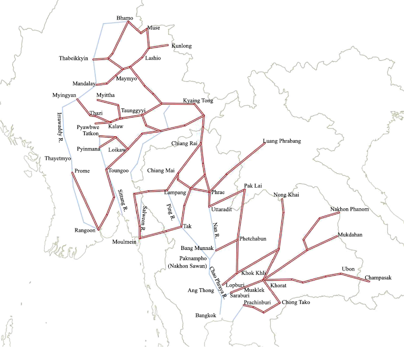
Fig. 1 Traditional Inland Waterways and Land Routes in Thailand and Burma
Sources: Kakizaki (2005, 23, 27; 2017, 6).
Steamers were introduced on the Chao Phraya River in the 1880s. The first regular steamers appear to have been mail ships operated by the Post and Telegraph Department on the route between Bangkok and Nakhon Sawan beginning in 1889 (Kakizaki 2005, 24).3) Since the Chao Phraya is a much smaller river than the Irrawaddy, the section navigable by steamer was relatively limited and changed with the seasons. During the rainy season, when the water level was at its highest, steamers could reach as far as Tak on the Ping River, the westernmost tributary of the Chao Phraya, about 500 km north of Bangkok, or Uttaradit on the Nan River, another tributary in the eastern Chao Phraya basin, located about 700 km north of Bangkok. It was a different story in the dry season, when the water level dropped to its lowest and steamers could reach only as far inland as Ang Thong, about 120 km north of Bangkok (Kakizaki 2005, 25). Navigation on the upper course was extremely difficult; oared vessels could be used to go northward beyond Tak or Uttaradit only during the rainy season. Therefore, land transport had to be used for moving goods in the upper Chao Phraya basin during the dry season.
The introduction of steamers led to a reduction in travel time. On the Irrawaddy, in 1910 the express steamer could sail upstream from Rangoon to Mandalay in seven days, a trip for which oared vessels would previously have taken about a month (Wright et al. 2015, 143). The time taken from Bangkok to Tak during the rainy season was reduced from twenty days to nine after the introduction of steamers (Kakizaki 2005, 24, 42).4) Naturally, the reduction in time was much more marked in upstream sailing since steamers could push against the current.
I-2 Animal-Powered Land Transport
While the introduction of steamers improved the efficiency of water transport, there was no evolution in land transport until the introduction of the railways; land transport had to rely on manual or animal power.
Land transport was inferior to water transport in tropical areas like Thailand and Burma. It was extremely difficult to walk or use pack animals for long periods of time during the day in tropical areas with high humidity, searing temperatures, and intense sunshine; humans and animals were forced to rest in the shade during the hottest part of the day. Frequent sudden squalls during the rainy season also hampered travel and often turned roads into muddy swamps. In fact, roads in lower river basins were usually flooded during the rainy season, forcing people to be heavily reliant on water transport. Therefore, land transport was generally regarded as a complement to water transport (Kakizaki 2005, 29).
Since the role of land transport was limited, most roads in these areas were secondary routes used as feeder networks for navigable rivers, which functioned as the main transport routes. As shown in Fig. 1, there were many feeder roads radiating from the Irrawaddy River to the inland areas of Upper Burma, although this map shows only the roads on the eastern bank of the Irrawaddy, especially those running to the Shan highlands. Two routes were extremely important: one from Mandalay to Lashio and the other from Myingyan to Taunggyi.5) Apart from feeder roads into inland areas, there were two trunk roads from Rangoon which were first constructed by the British colonial government for political and strategic reasons. Interestingly, the road to Prome was later largely converted into the railbed of the first railway in Burma (Maung Shein 1964, 42). Then, the colonial government built an alternative road to Prome and constructed another road to Toungoo; these two trunk roads were completed by the end of the nineteenth century (ARP 1899/00).
Thailand did not construct trunk roads radiating out from Bangkok until the 1930s; before that there were only feeder roads from the Chao Phraya and its tributaries.6) As shown in Fig. 1, the southernmost limits of the road networks in the Northern Region were Tak and Uttaradit, the northernmost points of steamer navigation during the rainy season, or the northernmost points on the middle Chao Phraya basin. Apart from the roads commencing from the tributaries of the Chao Phraya, there were two roads to Moulmein, another entrepôt for the Northern Region. Although transport conditions in the direction of Bangkok via the Chao Phraya were superior to those of the route to Moulmein, some high-value commodities such as raw silk and textiles were still transported between Moulmein and the Northern Region since the distance between them was shorter than the Bangkok route (Kakizaki 2005, 48–50). On the other hand, the roads heading toward the Northeastern Region originated from towns closer to Bangkok (about 150 to 200 km from the city), since the Dongphayayen Mountains—the range between the Chao Phraya and Mekong basins that lies close to Bangkok—presented a formidable barrier. The most important route was the road from Saraburi to Khorat, the gateway town to the middle Mekong basin.
Either pack animals or carts were used on these roads depending on the nature of the terrain and the road conditions. In mountainous areas such as the Shan highlands of Northern Thailand, pack animals were the most common form of transport. They were usually assembled into caravans of 100 to 200, carrying cargoes of 50 to 60 kilograms each. However, carts were used on specific routes where roads were sufficiently developed, such as between Mandalay and Maymyo (Kakizaki 2017, 7). On the other hand, carts were commonly used on the roads in flat Northeastern Thailand: the Khorat Plateau. One cart hauled by two oxen could convey about 180 to 240 kilograms (Kakizaki 2005, 33). However, only pack animals were feasible on the mountainous sections across the Dongphayayen mountain range.
I-3 Construction of the Railways
The railway was a new means of land transport involving the harnessing of a steam engine to a vehicle. Railways were introduced in Southeast Asia in the 1860s and rapidly became the most important means of transport in inland areas.
Burma was the second country in Southeast Asia to introduce a railway system, following the example of Java in the Netherlands East Indies. The first line was the Irrawaddy Valley Line between Rangoon and Prome, which opened in 1877, followed by the Sittang Valley Line between Rangoon and Toungoo, which was completed in 1885 (Kakizaki 2012, 5). These lines served as access routes to the border between Lower Burma—then a British colony—and the Konbaung Dynasty in Upper Burma. After the latter was annexed by Britain, the Sittang Valley Line was rapidly extended to Mandalay; the railhead reached Mandalay in 1889. From there, the railhead was pushed farther northward as the Mu Valley Line before terminating at Myitkyina in 1898 (Kakizaki 2012, 5). By 1900, two main lines from Rangoon and some branch lines had been constructed, as shown in Fig. 2.
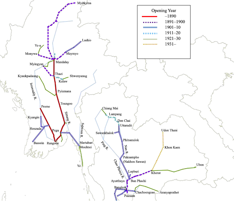
As the twentieth century progressed, railway construction kept pace. Between 1900 and 1910 the Northern Shan States Line was extended to Lashio, becoming the first railway to the Shan highlands, although ideas mooted about an extension to Kunlong were finally abandoned (Kakizaki 2012, 18). In Lower Burma several branch lines, like the lines to Martaban and Bassein, were also constructed during this decade. The tempo of construction dropped during the next decade; only part of the Southern Shan States Line and the short branch from Mandalay were completed (Kakizaki 2016, 5–6). New line construction resumed during the 1920s, ushering in lines such as the Kyaukpadaung Line and the Ye Line as well as the extension of existing lines to Ye-u and Shwenyaung. No further construction was carried out during the 1930s; the 3,300-km Burmese railway network had been completed by 1930 (Kakizaki 2012, 6).
Thailand lagged behind Burma in railway construction; its first railway was opened in 1893. Although several proposals for railway construction had been put forward since 1870, the government did not decide to commence any construction until 1890. Prompted by the fact that both Britain and France planned railway construction that would pass through a part of Thailand in the 1880s, the Royal Thai Government finally decided to construct its first railway between Bangkok and Khorat. Although construction did not progress smoothly, the first section between Bangkok and Ayutthaya opened in 1897 and the whole line was completed in 1900 (Kakizaki 2005, 90–92). Apart from state railways, several private railways were also constructed during the initial stage of railway construction. Hence, the first railway in Thailand was the 21-km private railway between Bangkok and Paknam, opened in 1893 (Kakizaki 2005, 93).
During the 1900s and 1910s, Thailand constructed two main lines from Bangkok: the Northern Line to Chiang Mai and the Southern Line to the border with Malaya. The construction of the Northern Line along the Chao Phraya began at the end of the nineteenth century, and by 1910 the railhead had reached the mountainous Northern Region (Kakizaki 2005, 102–104). Then the tempo of construction slowed down, hampered by the mountainous terrain and the shortage of construction materials caused by World War I. It was only in 1922 that the whole line as far as Chiang Mai finally opened (Kakizaki 2005, 113). The construction of the Southern Line also took a long time. Although the first section between Bangkok and Phetchaburi opened in 1903, any further extension toward the south was delayed; the main line to Padang Besar on the western Malayan border was completed in 1918, while another line to the eastern border at Sungai Kolok opened in 1921 (Kakizaki 2005, 104–105, 112–113). The first section of the Eastern Line to Chachoengsao was also constructed in the 1900s.
During the next two decades, railway construction was extended toward the east. Three eastward extensions were built during the 1920s and were finally completed by 1933: the Eastern Line to Aranyaprathet, on the French Indochinese border; and the Northeastern Lines to Ubon and Khon Kaen (Kakizaki 2005, 126–129). Although further extensions to Nong Khai and Nakhon Phanom from Khon Kaen had originally been planned, only the section between Khon Kaen and Udon Thani was actually constructed during the 1930s, finally opening in 1941 (Kakizaki 2012, 64–67). By 1941 Thailand had expanded its railway network to about 3,300 km, almost the same scale as in Burma.
II Changes in Traditional Transport in the Railway Era
II-1 Little Impact on Water Transport in Lower and Middle River Basins
With the construction of the railways, the existing commodity flows that had been dependent on traditional means of transport changed quite drastically in both Thailand and Burma. This was not a blanket operation; the level of change differed according to the traditional means of transport available in each area.
The impact of the railways was smallest in the areas in which water transport, especially steamers, was available. Table 1 shows the annual average volumes of important commodities transported between Upper and Lower Burma during the first half of the 1890s. As the railway between Rangoon and Mandalay was completed in 1889, these figures show the transport situation just after the competition between railways and water transport began.7) They reveal that the share of the railways was relatively low: 36 percent for outbound transport from Lower to Upper Burma and 11 percent for inbound transport from Upper to Lower Burma. The overall trend was that the railways had a higher share in outbound transport than inbound transport.
Table 1 Annual Average Volumes of Important Commodities Transported between Lower and Upper Burma (1890–96)
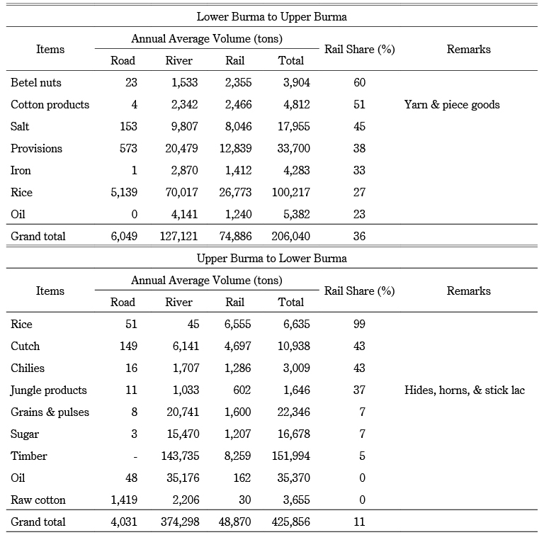
Sources: NITB (1Q 1890–4Q 1896).
Note: Each year corresponded to April to March of the next year. Years in the following tables are also the same.
The low share of inbound transport toward Lower Burma is attributable to the extremely low or nonexistent share of important commodities such as timber and oil: only 5 percent and zero, respectively. These commodities had accounted for a large share before railway construction.8) Since they were the two largest inbound transport items, as shown in Table 1, the total share of railway transport in inbound transport dropped below that of outbound transport. Certainly there were some items whose shares in railway transport were high, but bulky primary commodities were generally still transported by water.9)
The situation was the same in the Chao Phraya basin. Table 2 shows the annual average volumes of dispatch and arrival at main stations on the Northern Line in Thailand. The low volume of dispatch from Ayutthaya station shows the effect of competition from water transport. Although Ayutthaya was the most important rice-producing center in the Chao Phraya Delta, with the largest production volume in Thailand, there were almost no consignments of rice from there.10) In 1910 neither paddy nor rice was dispatched from this station, and even twenty years later only 31 tons of paddy and five tons of rice were dispatched (ARA 1910, Table 12; 1930, Table 7).11) The conclusion has to be that in the lower Chao Phraya basin, the railways seldom impinged on traditional commodity flows of water transport, especially along the main stream.
Table 2 Annual Average Volumes of Dispatch and Arrival in Main Stations on the Northern Line (tons)
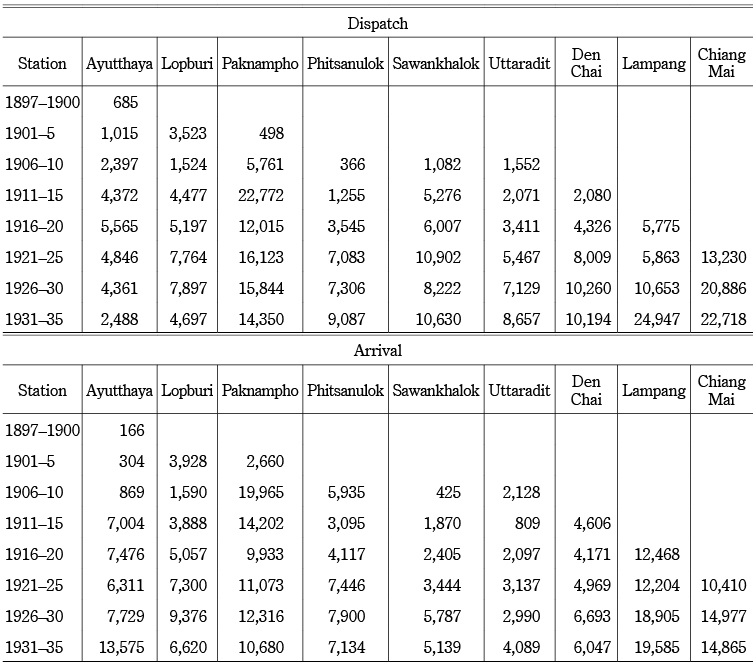
Sources: ARA (1897–1935).
Note: Excluding livestock.
The slight impact of the railways on water transport was primarily a consequence of the high cost of railway transport. Since the cost of water transport was lower than that of traditional land transport, the reduction in the cost of transport by rail was not sufficient to reduce transport costs on the routes on which water transport, especially by steamer, was available. For example, the cost of transporting rice by rail between Rangoon and Mandalay in 1895 was 8.05 rupees per ton, while the Irrawaddy Flotilla Co. levied 6 rupees for downstream and 7.5 rupees for upstream transport (Maung Shein 1964, 102). Since freight charges on the railways differed according to the unit price of the item transported, the gap widened for such high-value items as manufactured silk: 45.27 rupees by rail versus 24–30 rupees by steamer (Maung Shein 1964, 102). Although such gaps between railway and steamer transport were later corrected, it is safe to say that the railways did not help to reduce transport costs in the lower and middle river basins, in which water transport was far more convenient.
II-2 The End of Water Transport in the Upper River Basins
However, the railways did play an important role in the upper river basins as a substitute for water transport, which came at a greater cost and had seasonal limitations. The most typical example was the change in transport routes between Bangkok and Northern Thailand. As mentioned above, water transport in Northern Thailand had not been widely used; only oared vessels could be used during the rainy season. Therefore, as the railhead pushed its way northward, transport between Bangkok and the Northern Region gradually shifted from water to the railway.
The first change occurred when the railhead reached Paknampho (Nakhon Sawan) in 1905. Nakhon Sawan is at the confluence of two tributaries of the Chao Phraya, the Ping and the Nan. When the railhead reached there, some merchants began to use the railway between Bangkok and Paknampho, continuing upstream beyond the railhead on oared vessels. As Table 2 shows, both dispatch and reception volumes at Paknampho increased temporarily; the dispatch volume reached its peak during the first half of the 1910s, and for the reception volume the peak occurred in the latter half of the 1900s. The reason for the rapid increase in dispatches during the first half of the 1910s was the increase in paddy dispatches: from 3,546 tons in 1910 to 16,697 tons in 1915 (ARA 1910, Table 12; 1915, Table 6). Although the rapid increase in rail transport should have been partly due to the reduction in railway freight charge from Paknampho in 1910 (Kakizaki 2005, 161–163), the increase in the volume of rice from Chiang Mai meant that there was a larger quantity of grain to be transported (BTWM September 5, 1912).12) The advantage of using a combination of boat and rail was an overall saving in transport costs (DCR 1906, 7–8).13)
The extension of the railhead in 1910 ushered in the second change. That year the railhead reached mountainous Northern Thailand, where the rugged terrain gave rise to another form of combined transport: rail and caravan. Several traditional caravan routes passed through Northern Thailand, and merchants in this region now began to dispatch their caravans to the railhead at Uttaradit or Phrae to connect with rail transport to and from Bangkok. It is claimed that the caravans from Yunnan changed their destination from Moulmein to the railhead at Uttaradit in order to connect with the Bangkok-bound railway (DCR 1910, 9). At Lampang, a large proportion of imported textiles from Bangkok began to be transported via the railhead at Phrae in 1913, although some 300 oared vessels still plied their way down the river to Paknampho carrying primary commodities from Lampang (DCR 1913, 19). Although it was difficult to transport heavy, bulky primary commodities using pack animals, lighter and more valuable goods such as textiles could be taken to the Northern Region more conveniently using combined forms of transport.
The final change occurred with the arrival of the railway in the main cities in the Northern Region. After the railhead reached Lampang in 1916, the bulk of inland water transport to and from Paknampho disappeared (BTWM October 17, 1916). The decline in the volumes dispatched from Paknampho during the latter half of the 1910s, shown in Table 2, must have been caused partly by the reduction in water transport between Paknampho and the Northern Region. In contrast, after the opening of the railway, Lampang began to dispatch and receive large volumes of freight. The opening of the last section of the railway to Chiang Mai in 1922 also sounded the death knell for water transport on the upper Chao Phraya (Saratwadi 1996, 474–475). Table 3 shows an estimate of the freight transported by rail between Bangkok and the Northern Region in 1935: the Northern Region dispatched about 110,000 tons and received about 36,000 tons of freight. Since the conditions for both water and land transport in the upper river basin were very poor, the Northern Line had no difficulty absorbing almost all the trade between Bangkok and the Northern Region except teak, which will be mentioned later.
Table 3 Estimate of Railway Freight Transport to/from Bangkok in 1935 (tons)
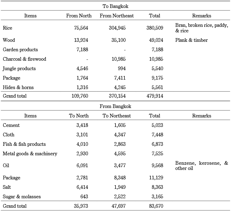
Sources: ARA (1935–36).
Note: Excluding livestock.
II-3 Decline in Animal-Powered Land Transport
Animal-powered land transport in the upper river basins was also mostly replaced by railways. Since animal-powered land transport was the most expensive and time-consuming means of transport, the railways absorbed most of the traditional commodity flows by pack animal or cart before expanding the existing commodity flows or creating new commodity flows.
Table 3 shows that freight transport between Bangkok and Northeastern Thailand carried larger quantities than did transport between Bangkok and the Northern Region. Since only pack animals had been available for crossing the Dongphayayen mountain range between Bangkok and the Northeastern Region, it is safe to say that almost all the commodity flow in Table 3 was created by the railways. Before the construction of the railway between Bangkok and Khorat, the annual volume of freight transport across the Dongphayayen was estimated at about 240 tons in either direction (Kakizaki 2005, 222). Before railway construction, the transport of bulky primary commodities such as rice and wood from the Northeastern Region to Bangkok was unprofitable because of the high cost of land transport, even were the transport possible. Therefore, the railway contributed to raising the commercial value of various primary commodities in the Northeastern Region.14)
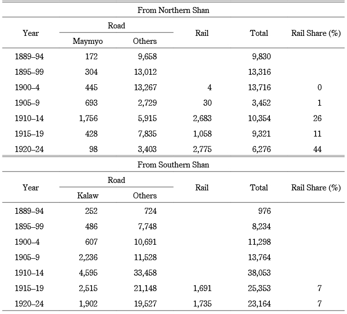
The effect of the railways on absorbing existing commodity flows created by animal-powered land transport is also clearly visible on the two Shan States Lines. Table 4 shows the annual average value of trade between Burma and the Northern Shan States. After the completion of the Northern Shan States Line in 1903, the existing trade via road was largely replaced by trade via the railway. The rail share had risen to 94 percent for export and 93 percent for import by the first half of the 1920s. While the trade value via rail was steadily increasing, the trade value via Maymyo, the parallel route overland, experienced a sharp decrease. It should be stressed that the railways not only replaced the existing trade by pack animals or carts but also expanded commodity flows as well as creating new commodity flows. The most important transport on this route was metals for export, such as lead and zinc. The most essential imports were oil and steel for smelting at the Bawdwin mine in the Northern Shan States (Kakizaki 2017, 9–10).
Table 4 Annual Average Trade Value to/from Burma in Northern Shan (thousand rupees)
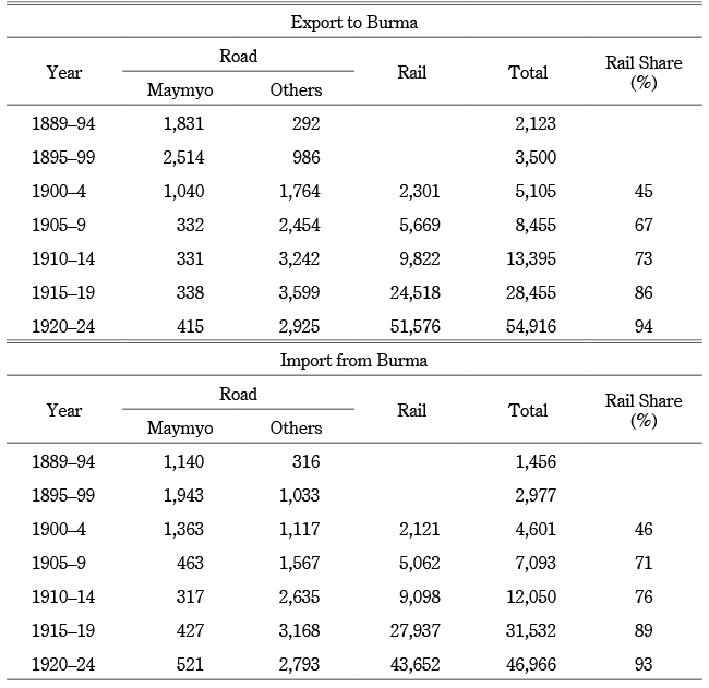
Sources: NTB (1889–1924).
A similar change was also observed in the Southern Shan States. Table 5 shows the trade between Burma and the Southern Shan States. As the construction of the Southern Shan States Line had been delayed, the expansion of trade following the opening of the railway was less than that experienced on the Northern Line. However, the rail shares of both exports and imports rose after the opening of the railway as far as Kalaw, the westernmost gateway to the Shan highlands, in 1914. The impact of the railway is clearly demonstrated by the rapid reduction in road trade via Kalaw, the most important trade route prior to railway construction, from the latter half of the 1910s. Although the total value of trade between the Southern Shan States and Burma was lower than that between the Northern Shan States and Burma, the only factor that made a real difference was the Bawdwin mine in the Northern Shan States (Kakizaki 2017, 9–10).
Table 5 Annual Average Trade Value to/from Burma in Southern Shan (thousand rupees)
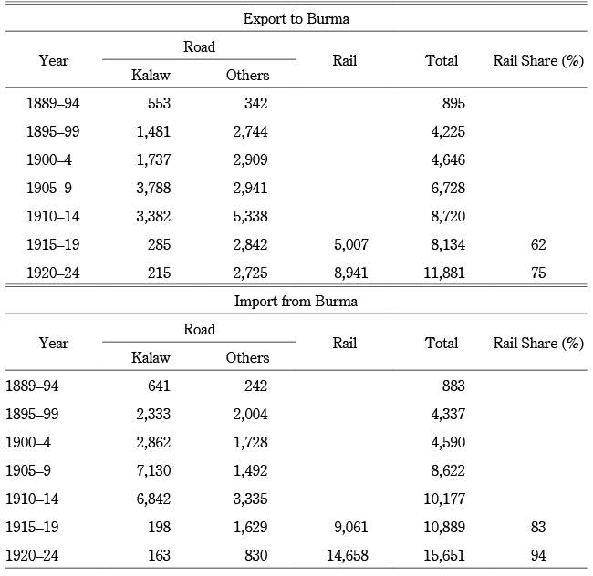
Sources: NTB (1889–1924).
Note: Trade via Kalaw includes trade registered at Kywelebin, Pyawbwe, Yabokson (up to 1911), and Kalow (after 1912).
It is obvious that the railways played an important role in reducing the cost of transport compared to animal-powered land transport. The average transport cost in the mountainous regions of Thailand before railway construction was about 0.5 baht per ton-kilo, roughly ten times higher than water transport by steamer or oared vessel (Kakizaki 2005, 29, 36). Thus, it was expensive to travel where water transport was unavailable; the transport cost from Bangkok to Khorat was estimated at 54 baht per ton, while it was only 16 baht to Nakhon Sawan, where water transport was available—although the geographic distance from Bangkok to both areas was similar (Kakizaki 2005, 45). However, the railways dramatically cut transport costs between Bangkok and Khorat by as much as 7.2 baht per ton for paddy transport (Kakizaki 2005, 162).15) Such a sharp reduction in cost was the most important factor in the disappearance of animal-powered land transport after the railways became available.
III Unaffected Traditional Transport
III-1 Floating Teak Logs
As mentioned above, the railways mostly replaced expensive traditional modes of transport: water transport in the upper river basin and animal-powered land transport. However, there were several exceptions where the railways failed to absorb traditional commodity flows between peripheral inland areas and their entrepôts. The most typical examples were teak logs and animals.
Teak was one of the most important export commodities from Burma and Thailand. During the 1890s, about 250,000 tons of teak were produced annually in Burma, including about 200,000 tons destined for export, mainly to India (Saito and Lee 1999, 107).16) The bulk of teak logs were transported to Rangoon or Moulmein by floating them down the Irrawaddy or the Salween, respectively. As Table 1 shows, most of the timber from Upper to Lower Burma was transported via river to Rangoon; only small consignments were transported by rail. During the 1890s, the annual export volume from Rangoon was about 120,000 tons, while Moulmein exported about 80,000 tons (FMSA 1886–96, 12).
While the main line between Rangoon and Mandalay did carry a certain volume of teak logs, the two branch lines to the Shan States played no role in transporting them. Table 6 shows the annual average dispatch of teak logs from the Shan States. The Northern Shan States dispatched more logs than the Southern Shan States after the second half of the 1900s: about 800,000–900,000 cubic feet were dispatched from the former in contrast to about 400,000–500,000 cubic feet from the latter. Since there is no record of teak log transport by rail during this period, all teak logs must have been floated downriver to Rangoon or Moulmein; those from the Northern Shan States headed to Rangoon via the Irrawaddy, while those from the Southern Shan States went down the Salween to Moulmein.17) The conclusion has to be that the railways at that time had no impact on the floating of teak logs from the Shan States.
The floating of teak from Northern Thailand, another important production center of teak in Southeast Asia, also remained unaffected, even after the opening of the Northern Line. The teak-felling industry in Northern Thailand was set up in the 1880s by European firms, mostly British. About 85 percent of the teak forest was under concession to Western firms, among them the Bombay Burmah Trading Co., the Borneo Co., and the East Asiatic Co. in 1930 (Kakizaki 2005, 196). Teak became the most important export item from the Northern Region. It was estimated that about 60 percent of the export value of the Northern Region lay in teak exports to Moulmein and Bangkok (DCR 1898, 5). As in the Shan States, teak logs from the Northern Region headed to different destinations depending on their origin; those in the Salween basin, mostly in Mae Hongson Province, headed to Moulmein, while those in the Chao Phraya basin went down to Bangkok.
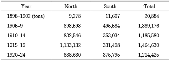
The increase in log floating to Bangkok turned out to be more than the increase on the Moulmein route. As Table 7 shows, the numbers of logs headed to Bangkok and Moulmein were almost the same around 1890. Then the number to Bangkok increased, but the number destined for Moulmein decreased during the 1890s and 1900s. As of the mid-1930s, the volume of logs to Bangkok was about three times larger than the volume of logs bound for Moulmein. Despite this growth spurt, there was almost no transport of teak logs from the Northern Region to Bangkok by rail. About 14,000 tons of timber were dispatched from the Northern Region to Bangkok by rail in 1935, but none of it seems to have been teak (Kakizaki 2005, 225).18) Although there were several industrial railways built by European felling firms to transport teak logs from the forests to the nearest rivers in the Northern Region, the only transport route from the Northern Region to Bangkok remained the Chao Phraya and its tributaries (Kakizaki 2005, 202–203).
Table 7 Annual Average Dispatch Volume of Teak from Northern Thailand (logs)
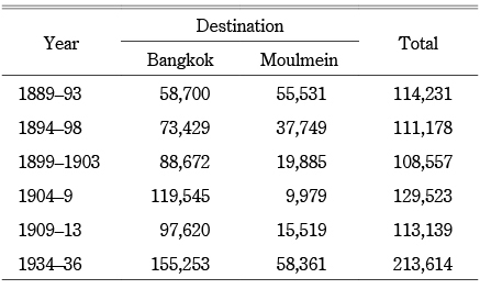
Sources: DCR (1891–); SYB (1935/36–36/37).
Note: Volumes to Bangkok are volumes arrived at Chainat up to 1894 and Paknampho after 1895.
The reason log floating remained unaffected by modern transport was its extremely low cost. The cost to transport one teak log from the Northern Region to Bangkok was eight rupees (about nine baht) during the 1880s (Satow 1994, 171). Since logs floated naturally downstream, almost no transport costs were incurred after they were put into the river. It is true that the logs took a long time—usually three to five years—to arrive at their destination, but there were almost no problems or damage (Kakizaki 2005, 196–197). Therefore, even when all other river trade had disappeared from Northern Thailand after the opening of the railway to Lampang and Chiang Mai, log floating remained unaffected.
III-2 Walking Animals
Another traditional means of transport that remained unaffected was the walking or driving of animals: cattle, buffalo, mules, and horses. Cattle and horses were usually used as draught power—either pulling carts and wagons or serving as pack animals—while buffalo played an important role in plowing. Since they could walk a long distance for a long time, traditionally they would be driven from the Shan States to Upper and Lower Burma and from Northeastern or Northern Thailand to the Central Region in order to be sold.
In Thailand, the Northeastern Region was the most important area for the supply of cattle and buffalo; mules and horses were a rare sight. Most of the cattle were sold to merchants who would export them from Bangkok, while most buffalo were sold to farmers in the Chao Phraya Delta (Kakizaki 2005, 55–56). These animals, along with jungle products such as stick lac (lac in its natural setting, encrusted on leaves and twigs), cardamom, and hide and horns were the main export items from the Northeastern Region before the opening of the railways (Kakizaki 2005, 63). However, only a limited number of these animals were actually carried by rail after the railhead reached the region. Table 8 shows that the average annual number of cattle and buffalo dispatched from the Northeastern Region was about 2,400 during the first half of the 1900s, accounting for 43 percent of total railway transport. However, the share of transport from the Northeastern Region decreased after that, recording its lowest share in the first half of the 1930s.19) In fact, the main livestock carried on Thai railways was not cattle or buffalo but pigs.20)
Table 8 Annual Average Number of Cattle and Buffalo Transported on Thai Railways (head)
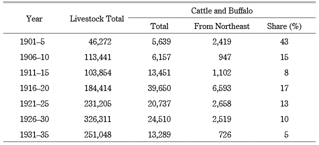
Sources: ARA (1897–1935).
Note: Excluding buffalo up to 1915.
With the railways transporting fewer than 1,000 head of cattle and buffalo during the first half of the 1930s, most of the animals still walked across the mountain range from the Northeastern Region toward the Chao Phraya basin. Table 9 shows the average annual numbers of cattle and buffalo that passed through quarantine stations, most of them located on the border between the inland regions and the Lower Central Region, in the mid-1930s. It shows that more than 40,000 head of cattle and buffalo walked from the inland regions toward the Central Region, 86 percent of them from the Northeastern Region. The number of cattle and buffalo transported by rail from the Northeastern Region decreased after peaking in the latter half of the 1910s, as shown in Table 8, and inevitably dropped during the 1930s.
Table 9 Annual Average Number of Cattle and Buffalo toward Bangkok and Lower Central (1935–37) (head)
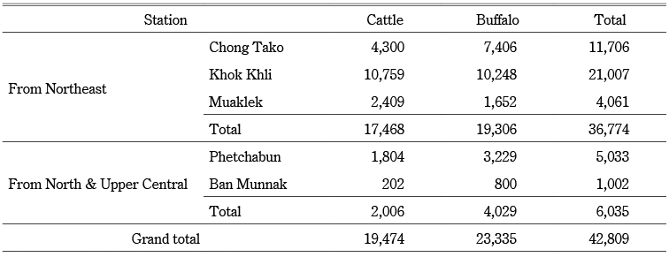
Sources: NA [2] So Ro. 0201. 35. 2/9.
The transport of animals from the Shan highlands to Upper and Lower Burma was also common. In contrast to Thailand, mules and horses were among the animals transported on this route, especially from the Northern Shan States. In 1900 the Northern Shan States exported 1,412 head of horses and mules and 189 head of cattle, while the Southern Shan States exported 698 head of horses and 9,177 head of cattle (NTB 1900, 8–13). As shown in Table 10, the number of animals exported from the Northern Shan States decreased sharply during the latter half of the 1900s, causing a sudden fall in “other animals” exported via the Bhamo route in 1903.21) After the 1910s, the export of sheep and goats also increased, especially from the Northern Shan States; the number reached its peak of 3,169 head in 1920 (NTB 1920, 13).
Table 10 Annual Average Number of Animals toward Burma (head)
Sources: NTB (1889–1924).
Note: Trade via Kalaw includes trade registered at Kywelebin, Pyawbwe, Yabokson (up to 1911), and Kalow (after 1912).
Although the share of animal transport by rail was not as low as on the Northeastern Line in Thailand, the role of the railways in animal transport remained small. Table 10 shows that the Northern Line had a higher share in animal transport, while the Southern Line played a more modest role. Since the number of animals being driven along the Maymyo and Kalaw routes decreased after the opening of the railways, it has to be concluded that the railways absorbed a certain volume of the animal transport from parallel road routes. However, since the major routes for animal transport did not run parallel to the railway tracks, the driving of animals remained unchanged on these routes even after the opening of the railways, especially in the Southern Shan States.22)
The main reason behind the preference for animal walking rather than rail transport was the low cost of walking. While rail transport required a freight charge, the driving of animals under their own steam was free. Although it took a considerably longer time, animals could walk toward their destination, fueled by the plentiful dry grass in the fallow rice fields; neither transport costs nor food costs had to be incurred.23) A report by Henry Gittins (1908, 31–49), a British railway engineer in the Department of State Railways in Thailand, noted that the number of cattle dispatched by rail from Khorat in Northeastern Thailand decreased in 1906 as merchants saved the railway freight charge of seven baht per head by driving the livestock along trails parallel to the railway tracks. Thus, saving freight charges was the main reason why this traditional form of transport remained unaffected by the railways.
IV The Failure of the Railways to Monopolize Transport
IV-1 Higher Transport Cost of Railways
As mentioned above, although the railways in Thailand and Burma were the most modern means of transport at the time and largely replaced traditional means of transport, they could not monopolize the whole commodity flows of traditional transport. Of course, railways were almost completely irrelevant to micro-level short-distance local transport such as between a village and its nearest market town; and even in middle- and long-distance transport, some traditional commodity flows survived after the advent of the railways.
Although railways were the most modern means of transport, their effect on the improvement of transport conditions was limited. Compared to other means of transport, railways were unquestionably the fastest, aside from water transport by steamer. However, they were not the cheapest: coastal railways frequently came out worse in a comparison to coastal steamer lines. One such example was the Southern Line in Thailand. The majority of transport between Bangkok and the Southern Region bordering on the Malay Peninsula was still the preserve of coastal navigation, even after the completion of the Southern Line in the 1910s (Kakizaki 2005, 238–241). Even in inland areas, such as Mandalay in Upper Burma, the cost of water transport was generally lower than railway freight charges. Hence, it can be surmised that the role of the railways in the reduction of transport costs was limited on any route on which water transport by steamer or motorboat could be conveniently used all year round.
That said, railways were able to replace traditional transport on routes on which year-round convenient water transport was not available, with the exception of teak-log floating and livestock driving. All railways penetrating mountainous terrain—among them the Northern and Southern Shan States Lines and the Northern and Northeastern Lines in Thailand—were able to monopolize a large part of existing commodity flows and expand them; teak and animal transport were the exception rather than the rule. The reason such traditional transport survived was quite simple: it was seemingly free. Teak logs could float downstream freely, even though it took a considerably long time for them to arrive at their destination. Animals such as cattle and buffalo were also able to walk long distances free of charge, even though it took a couple of weeks or months before they reached their destination. It can be said that such “free” transport was environment friendly, since there was no need to consume fuel.
This “free” transport was possible since there was no need to use either ships or vehicles. Floating teak logs had no need of ships; the only assistance they required was the traction of logs by animals, usually elephants, when they jammed in rapids or on sandbanks (MCC 1930, 131–132). Animals also needed no vehicles to transport them; they could walk by themselves.
Although railway freight charges were generally higher than year-round water transport, the railway authorities in Thailand and Burma did not levy excessive charges, at least for teak log transport; it was the third lowest charge among seven categories in 1910 in Thailand (Kakizaki 2005, 162).24) The railways did not aggressively promote teak transport by giving special discounts as they did with paddy, but they had no intention of hampering teak transport by levying too high charges. Nevertheless, it was extremely difficult for the railways to compete with the apparent free transport even though they charged the lowest amounts possible. Therefore, traditional modes of transport were regarded as the most economical means of moving commodities.
It is worth noting that it was not only the indigenous people who recognized the value of free transport. It did not take long for European firms to catch on to its advantages. In Thailand, Tongsu or Lao merchants who brought animals from the Northeastern Region to the Central Region preferred free transport, but the Indian merchants who bought them in the Central Region did begin to use railways to convey them to Bangkok (Kakizaki 2005, 225–226).25) For example, Lopburi dispatched the largest number of cattle—2,130 head—in 1910, followed by Chachoengsao with 1,211 head and Saraburi with 638; all of these places were located in the Lower Central Region (ARA 1910, Tables 12, 13). When they had the choice of floating teak logs, Western felling firms also decided to continue to use this free mode of transport even though railways were available.
Since there were few goods that needed rapid transport at the time, the longer time taken by water transport was not a critical problem for most merchants.26) Therefore, the cheaper rather than faster means of transport was usually selected. This was the most important reason for the survival of traditional transport.
IV-2 The Actual Cost of “Free” Traditional Transport
However, “free” traditional transport was not really free: there were various losses and indirect costs involved. For one, there was the risk of fire, loss, and theft. Since teak forests were usually burned at the end of the dry season, fire guards were employed to prevent the burning of logs (MCC 1930, 132). This sort of protection was important when teak logs were lying inert on the dry riverbeds before the water level rose. Since there were not enough guards to ensure smooth flotation, not a few logs went missing or were stolen on the way to their destination (Andrus 1948, 104–105). During the decade between 1948 and 1957, the Forest Industry Organization of Thailand floated a total of 834,013 teak logs down rivers; of these, 30,866 logs—or about 4 percent—did not arrive at the forest checking station at Paknampho (UPO 1997, 38).27) Such straying or theft, of course, added indirectly to the total transport cost.
The free transport of animals also entailed an indirect cost: that of personnel. Animal walking or driving required considerable manpower to ensure the livestock reached their destination. For example, in April 1890 a group of animal traders—three Tongsu and 110 Lao—with 109 head of cattle, 971 head of buffalo, and two ponies were attacked by a hundred bandits at Chong Samran, on the major animal-driving route from Northeastern Thailand to the Central Region.28) Although it is unclear whether all the Lao had been hired for transportation or not, the traveling cost for a hundred persons for several months, including the cost of board and lodging, would not have been cheap. Therefore, “free” animal transport also had to take account of the travel costs of large numbers of men for a long time.
When comparing rail transport, which involved a freight charge, with “free” traditional transport, the latter would no doubt have seemed more economical. However, if the indirect costs had been added, the free transport would no longer be free. Although it is difficult to judge whether the indirect costs of free transport were higher than railway freight charges, it has to be said that many people, including Europeans, recognized that railway freight charges were by no means cheaper than the indirect costs of traditional transport. Indian merchants who had switched to using the railways for transporting animals from the Lower Central Region to Bangkok might have realized that the total cost of water transport—including indirect costs—was higher than the total cost of rail transport, since the direct cost of water transport within the lower river basin was clearly lower than that of rail transport. Even though there might have been some people who understood the actual transport cost, it was likely difficult for most to grasp it.
IV-3 The End of Traditional Transport
Although the “free” traditional transport of teak and animals survived after World War II, it had disappeared by the 1980s, at least in Thailand. The first obstruction to teak transport by floating was the construction of dams in Thailand. Of the dams on the four tributaries of the Chao Phraya, the first, the present Phumiphon Dam, was planned on the westernmost Ping River. When the construction of the dam began in 1961, it ended the possibility of floating teak logs from the Ping basin, where Chiang Mai was located. Therefore, the Forest Industry Organization began transporting logs from the Northern Region by rail in 1958. This was virtually the first instance of teak logs being transported by rail in Thailand (UPO 1997, 39). In 1966 the volume of timber arriving in Bangkok via the Northern Line was 35,177 tons—the largest volume among the three main lines.29) In a nutshell, the construction of dams was the turning point in the decline of log floating.
However, the traditional transport of teak logs below the dams or in the basins of other tributaries still continued. In 1975, 76,369 teak logs arrived at the forest checking station at Paknampho (SYB 1976–80, 238). Although it is not known when exactly log floating ended, it must have been by the end of the 1980s, if for no other reason than because of the exhaustion of forest resources. In 1977 the government prohibited the export of teak timber, sounding the death knell for teak exports from Thailand (UPO 1997, 112). After severe floods ravaged Southern Thailand in 1989, the government decided to prohibit all commercial logging in natural forests; this was the virtual end of “legal” forestry in Thailand (UPO 1997, 112). Therefore, the free traditional transport of teak logs finally disappeared; but it also has to be said that it coincided with the end of the “modern” transportation of teak logs by rail and road.
The first turning point in free animal transport had occurred earlier. When Thailand entered World War II at the end of 1941, it was compelled to run several military trains for the Japanese army. This led to a reduction in the capacity of civilian transport (Kakizaki 2012, 84–85). After the stagnation of pig transport from Northeastern Thailand, the major supply center of pigs for Bangkok, meat-processing factories in Bangkok planned to increase their supply of beef by bringing cattle from the Northeastern Region.30) Since the transportation of cattle had to begin in June, at the beginning of the rice cultivation season, traditional cattle driving was out of the question.31) This was because the free traditional transport of animals depended on fallow rice fields for its route and fodder; wet rice fields were unsuited to cattle driving. The demand for cattle also increased as the Japanese army required large volumes of beef for its soldiers. Therefore, the number of cattle and buffalo transported by rail during the war rose sharply, reaching its peak of 42,098 head in 1943 (ARA 1947, Table 13).
The second turning point was the partial prohibition of the traditional transport of animals in 1954. After the war, Thailand suspended the export of animals in order to cater to domestic demand before resuming foreign trade in animals.32) However, since many countries were aware of the diseases harbored by imported animals, Thailand was forced to introduce new regulations prohibiting the export of animals procured via traditional transport since the possibility of their becoming infected with diseases while on foot was far greater than if they were conveyed by rapid and isolated means of transportation.33) Therefore, the driving of animals for export from the Northeastern Region had to be replaced by rail or motor transport. Although it is not known when the “free” traditional transport of animals for domestic use ended, the development of highway networks during the 1960s, after the 1958 opening of the Friendship Highway—the first high-quality highway connecting Bangkok and the Northeastern Region—probably heralded its demise. Pertinently, it was not rail but road transport that finally replaced the traditional transport of animals.
Traditional forms of transport continued until the 1980s in Thailand. They may have survived longer in Burma, where the development of infrastructure was delayed. Environment-friendly traditional transport in Thailand was finally brought to an end by the government’s infrastructure development and regulations. In the final analysis, the end of “free” traditional transport was ushered in by its prohibition rather than any financial understanding of its real indirect costs. As long as it was recognized that traditional forms of transport were free, these modes of transport survived.
Conclusion
This article has aimed to analyze the limitations of rail transport in Thailand and Burma before World War II, focusing on the inland transport between entrepôts and their hinterlands. Before the railway age, traditional means of transportation—both water transport and animal-powered land transport—had been used. While water transport saw some technological advancements with the introduction of steamers during the latter half of the nineteenth century, animal-powered land transport remained unchanged. The best water transport conditions were to be found in the lower and middle river basins, where steamers were best suited and the conditions for animal-powered land transport were the worst. Therefore, when railways were constructed in inland areas, they absorbed most of the commodity flow of water transport in the upper river basins and most of the animal-powered land transport, but their role in replacing water transport by steamer was limited.
There were two exceptions where traditional transport was not replaced by railways: teak-log transport and animal transport from the inland regions. Even after the completion of the railways, teak logs from the Shan States and Northern Thailand were floated downriver to their destinations, and animals such as cattle and buffalo were still brought to market by driving them over long distances. Since there was no need to charter any ships or rent carts, these two methods were apparently regarded as free. As long as people were not fully aware of the actual costs of these traditional modes of transport, the railways made little headway in replacing them. The end of traditional transport came not because of the introduction of modern alternatives, but due to prohibitions placed on the movement of animals.
This article has focused only on Thailand and Burma, for which there are sufficient sources revealing the survival of traditional transport after the beginning of the railway age. However, it is quite possible that traditional transport survived long after in other areas of Southeast Asia. Although there is some uncertainty about whether sufficient sources are available, it is worth promoting the study of transport and commodity flows in other areas in search of such data.
Accepted: November 1, 2022
References
Primary Sources
National Archives of Thailand (NA)
Department of Royal Secretary Records, the Rama V Reign (Ekkasan krom ratcha lekhathikan, ratchakan thi 5: Ro. 5)
Ministry of Interior files (Krasuang mahatthai: Ro. 5 Mo.)
Ministry of Agriculture Records (Ekkasan krasuang kasettrathikan: Ko So.)↩
Ministry of Communications Records (Ekkasan krasuang khamanakhom: Kho Kho)↩
Secretariat of the Cabinet Records (Ekkasan samnak lekhathikan khana ratthamontri: [2] So Ro., [3] So Ro.)↩ ↩ ↩ ↩
Supreme Commander Headquarters Records (Ekkasan kong banchakan thahan sungsut: Bo Ko. Sungsut)↩
Annual Reports, Statistics, Newspapers, Periodicals
Administration Report of the Public Works Department, Burma (ARP)↩
Annual Report on the Administration of the Royal State Railways, Siam (ARA)↩ ↩ ↩ ↩ ↩ ↩ ↩ ↩ ↩ ↩
Bangkok Times Weekly Mail (BTWM)↩ ↩
Diplomatic and Consular Reports on Trade and Finance, Siam: Report on the Trade and Commerce of the Consular District of Chiengmai (DCR)↩ ↩ ↩ ↩ ↩
Furnival’s Manuscript, Statistical Appendix (FMSA)↩ ↩
Note on the Internal Trade of Burma (NITB)↩ ↩
Note on the Transfrontier Trade of Burma (NTB)↩ ↩ ↩ ↩ ↩ ↩ ↩ ↩ ↩ ↩
Statistical Yearbook, Siam (SYB)↩ ↩
Secondary Sources
Andrus, J. Russell. 1948. Burmese Economic Life. Stanford: Stanford University Press.↩
Cheng Siok-Hwa. [1968] 2012. The Rice Industry of Burma 1852–1940. Singapore: ISEAS (reprint).↩
Dick, Howard and Rimmer, Peter J. 2003. Cities, Transport and Communications: The Integration of Southeast Asia since 1850. Basingstoke: Palgrave Macmillan. https://doi.org/10.1057/9780230599949.↩
Feeny, David. 1982. The Political Economy of Productivity: Thai Agricultural Development 1880–1975. Vancouver: University of British Columbia Press.↩
Furnivall, J. S. 1956. Colonial Policy and Practice: A Comparative Study of Burma and Netherlands India. New York: New York University Press.↩
Gittins, Henry. 1908. Raingan Mr. Gittins truat kan tham thang doen lae kan khakhai rawang mueang Nakhon Ratchasima kap mueang Prachinburi รายงาน มิศเตอร์ กิตตินส์ ตรวจการทำทางเดินแลการค้าขายระหว่างเมืองนครราชสีมากับเมืองปราจีนบุรี [Mr. Gittins’s report of inspection for the construction of footpaths and the trade between Nakhon Ratchasima and Prachinburi]. Thetsaphiban เทศาภิบาล 6(32): 31–49.↩
Grant, J. W. [1939] 1958. The Rice Crop in Burma: Its History, Cultivation, Marketing & Improvement. Rangoon: Government of Burma (reprint).↩
Kakizaki Ichiro. 2017. Biruma Shan tetsudo no kaitsu to butsuryu no henyo 1890–1924 nen ビルマ・シャン鉄道の開通と物流の変容 1890~1924年 [The opening of the Shan State Railways and the change in commodity flows in Burma, 1890–1924]. Tetsudo shigaku 鉄道史学 [Japan railway history review] 35: 5–18.↩ ↩ ↩ ↩ ↩ ↩ ↩
―. 2016. Senzen-ki Biruma tetsudo no kamotsu yuso: Gaiko-kohaichi-kan tetsudo no yuso bunseki 戦前期ビルマ鉄道の貨物輸送―外港~後背地間鉄道の輸送分析 [Railway freight transport on Burmese railways before World War II: The analysis of transport between entrepôt and its hinterland]. Yokohama Ichiritsu Daigaku ronso jimbunkagaku keiretsu 横浜市立大学論叢人文科学系列 [Bulletin of Yokohama City University, humanities] 67(2, 3): 1–43. http://doi.org/10.15015/00001175.↩ ↩ ↩ ↩
―. 2012. Rails of the Kingdom: The History of Thai Railways. Bangkok: White Lotus.↩ ↩ ↩ ↩ ↩ ↩
―. 2005. Laying the Tracks: The Thai Economy and Its Railways 1885–1935. Kyoto: Kyoto University Press.↩ ↩ ↩ ↩ ↩ ↩ ↩ ↩ ↩ ↩ ↩ ↩ ↩ ↩ ↩ ↩ ↩ ↩ ↩ ↩ ↩ ↩ ↩ ↩ ↩ ↩ ↩ ↩ ↩ ↩ ↩ ↩ ↩ ↩ ↩ ↩
Maung Shein. 1964. Burma’s Transport and Foreign Trade in Relation to the Economic Development of the Country (1885–1914). Rangoon: University of Rangoon.↩ ↩ ↩ ↩ ↩ ↩
Saito Teruko and Lee Kin Kiong. 1999. Statistics on the Burmese Economy: The 19th and 20th Centuries. Singapore: Institute of Southeast Asian Studies.↩
Saratwadi Ongsakun สรัสวดี อ๋องสกุล. 1996. Prawattisat Lan Na ประวัติศาสตร์ล้านนา [History of Lan Na]. Bangkok: Amarin.↩
Satow, Ernest. [1885] 1994. A Diplomat in Siam: H.B.M. Minister-Resident, Bangkok, 1885–88. Gartmore: Kiscade (reprint).↩
Thailand, Ministry of Commerce and Communications (MCC). 1930. Siam: Nature and Industry. Bangkok: MCC.↩ ↩ ↩
Thiam Khomkrit เทียม คมกฤษ. 1971. Kan pamai nai Prathet Thai การป่าไม้ในประเทศไทย [Forestry in Thailand]. Bangkok: Cremation Volume for Thiam Khomkrit.↩
Utsahakam Pamai, Ongkan (UPO) อุตสาหกรรมป่าไม้, องค์การ. 1997. 50 pi Ongkan Utsahakam Pamai 50 ปีองค์การอุตสาหกรรมป่าไม้ [50th anniversary of Forest Industry Organization] Bangkok: UPO.↩ ↩ ↩ ↩
Wright, Arnold; Cartwright, H.A.; and Breakspear, O. [1910] 2015. Twentieth Century Impressions of Burma: Its History, People, Commerce, Industries, and Resources. Bangkok: White Lotus (reprint).↩ ↩ ↩
1) NITB contains the statistics of commodity flows between Lower and Upper Burma via railway, river, and road between 1890 and 1896. This is one of the main sources used by Kakizaki (2016). NTB contains the statistics of the trans-frontier trade of Burma, including trade between Burma and the Shan States, between 1889 and 1924. Since the trade volumes of each item/transport mode passing through each border are available, the transport volume via railway and road can be calculated; these have been utilized by Kakizaki (2017). ARA is the administration report of the Department of State Railways in Thailand, with the statistics of dispatch and arrival volume of each item at the main stations; this was the main source for Kakizaki (2005). However, few other studies have utilized them, as far as the author knows.
2) The original company, founded in 1865, was the Irrawaddy Flotilla and Burmese Steam Navigation Co. Ltd., which was reorganized as the Irrawaddy Flotilla Co. Ltd. in 1875 (Maung Shein 1964, 29–30).
3) The frequency of these steamers was as follows: three round trips per week between Bangkok and Ayutthaya, and two round trips per month between Ayutthaya and Nakhon Sawan.
4) However, it took 29 days during the dry season, since the distance steamers could cover was curtailed and the speed of oared vessels also dropped. For details, see Kakizaki (2005, 36–43).
5) These two roads were first developed as cart tracks in the Northern and Southern Shan States, respectively (Kakizaki 2017, 6–12).
6) Thailand adopted a railway-oriented policy during the 1920s. It tried to avoid competition between railways and roads until the constitutional revolution in 1932. Only feeder roads radiating from railways were constructed during this period. For details, see Kakizaki (2005, 117–151).
7) However, these figures were collected on the border between the two regions; they did not target only transport between Rangoon and Mandalay.
8) In 1883–84, the transport volumes of timber and oil from Upper to Lower Burma were 40,000 tons and 1.1 million gallons (about 5,000 tons), respectively (FMSA 1869–1886, 12).
9) The share of the railways was to some extent dependent on point of origin. For example, the lion’s share of inward-bound rice—the commodity that accounted for the largest share of rail transport—originated in Kyaukse, which was far from the Irrawaddy but in close proximity to a railway station (Kakizaki 2016, 19).
10) In 1911–12, Ayutthaya Province produced 464,962 tons of rice, the largest volume among the 25 provinces for which figures are available (NA Ko So. 13/733, 735, 747, 748, 1043, 1142, 1180, 1187).
11) The arrival volume in Ayutthaya increased in the first half of the 1910s because of the rapid increase in the import of firewood.
12) In 1910 the Department of State Railways reduced freight charges to promote the transport of goods by rail and introduced a special discount rate for paddy transport from Paknampho to Bangkok to compete with water transport (Kakizaki 2005, 161–163).
13) Transport by railway saved about 150–200 baht per ten-ton freight transport on a round trip from Lampang to Bangkok.
14) The opening of the railway as far as Khorat was an important turning point, as bulky commodities from the Northeastern Region such as rice and wood were emerging as major export items to Bangkok. For details, see Kakizaki (2005, 152–252).
15) This figure is based on the revised freight charge in 1910. It was more expensive before the revision.
16) This excludes the teak from the Karenni States and Siam, amounting to about 60,000 tons.
17) During the latter half of the 1900s, there was a temporary dispatch of timber other than teak on the Northern Shan States Line, amounting to about 40,000 cubic feet per year.
18) These logs were Burma padauk (Pterocarpus macrocarpus) or mai pradu, largely found in teak forests in Northern Thailand (MCC 1930, 135).
19) The extraordinarily large number of dispatches from the Northeastern Region during the latter half of the 1910s was the result of a sharp increase in dispatches in 1919 and 1920, perhaps caused by the poor rice harvest during this period.
20) For pig transport on the Thai railways, see Kakizaki (2005, 186–195).
21) There were about 10,000 to 20,000 head of “other animals” exported via the Bhamo route until 1902. However, because of a mistake in registration, the number of other animals via this route fell from 14,869 head in 1902 to just 140 head the following year (NTB 1902, 4; 1903, 1, 6).
22) In 1920, 10,590 head of animals were exported on the Toungoo route (including the Leiktho route), accounting for 48 percent of the total exports from the Southern Shan States (NTB 1920, 16–17).
23) The driving of animals took place during the dry season after the rice harvest. This ensured that plenty of dry grass and hay was available for fodder on the vast harvested rice fields.
24) For example, the transport charge for teak from Uttaradit to Bangkok was 6.9 baht per ton, which was 25 percent higher than the transport charge for paddy but 40 percent lower than silk and almost 80 percent lower than packages (Kakizaki 2005, 162).
25) Tongsu are one of the Karen ethnic groups that emigrated from around the mouth of the Salween to the Thai-Burmese border. They often traveled to the Mekong basin to buy animals and woven silk to take back to Moulmein (Kakizaki 2005, 265).
26) Pigs were the only livestock that required rapid transportation by rail.
27) The Forest Industry Organization was founded in 1947 by the government with the aim of promoting the forestry business (Thiam 1971, 65–66).
28) NA Ro. 5 Mo. 2. 12 Ko. (Nakhon Ratchasima)/6 “Bai Bok Phra Phirenthep. May 24, 1890.” It was reported that all of the animals had been stolen by bandits.
29) NA Kho Kho. 0202. 9/369 “Kan Khonsong Sinkha Lak nai Suan Phumiphak Khao Su Talat Krungthep.” The other two lines were the Northeastern Line and the Southern Line.
30) NA [2] So Ro. 0201. 98/20 “Rai-ngan Kan Prachum Khana Kammakan Prasan-ngan Thahan-Phonlaruean Khrang thi 31/85. June 11, 1942.”
31) NA Bo Ko. Sungsut 2. 10/103 “Phu Amnuaikan Rong-ngan Nuea lae Nom Thueng Khana Kammakan Phasom. August 22, 1942.”
32) NA [3] So Ro. 0201. 32/49 “Sunthon Hongladarom Rian Lekhathikan Khana Ratthamontri Fai Borihan. September 6, 1954.”
33) NA [3] So Ro. 0201. 32/64 “Chalit Kunkamthon Rian Phana Nayok Ratthamontri. September, 1958.”
![]()
