![]()
Contents>> Vol. 10, No. 1
Intensification of Rice Cultivation in the Floodplain of the Chao Phraya Delta*
François Molle,** Chatchom Chompadist,*** and Thanawat Bremard**
*This article is dedicated to the late Professor Takaya and his colleagues from Kyoto University’s Center for Southeast Asian Studies, who carried out seminal work on the Chao Phraya Delta in the 1970s and 1980s.
**G-Eau, Institut de Recherche pour le Développement (IRD), 361, rue JF Breton, BP 5095, 34196 Montpellier Cedex 5, France
Corresponding author (Molle)’s e-mail: francois.molle[at]ird.fr
***ชัชชม ชมประดิษฐ์, Royal Irrigation Department, Samsen Nakornchaisri Dusit Bangkok 10300, Thailand
DOI: 10.20495/seas.10.1_141
Over the past 50 years rice cultivation in Asian deltas has undergone impressive intensification. In the Chao Phraya Delta, Thailand, traditional deepwater and floating rice varieties have gradually been replaced by high-yield varieties (HYVs). However, until recently a floodplain of 300,000 ha was still cultivated with traditional varieties. We analyze how these varieties came to be replaced by single/double cropping of HYVs and describe the new water regime that has been established, taking the Bang Kum drainage basin as an illustration. While the shift brought a welcome increase in rural incomes, we show how the change in water management has had serious negative cross-scale consequences that have not been considered. We end by discussing the government’s plan to alter the water regime in the area again, as part of its “monkey cheek” (flood retarding) policy. We show that rather than enhancing management flexibility and the floodplain’s buffering capacity, as it claims, this policy in fact undermines both.
Keywords: deepwater rice, rice cultivation, flood management, flood retarding basin, Chao Phraya Delta, Thailand
I Introduction
Asian deltas’ landscapes and water regimes—most notably the Pearl River, the Red River, the Mekong, and the Chao Phraya River—have undergone spectacular historical transformations (Catling 1992; Tanaka 1995; Kono 2001; Molle and Dao Thê Tuân 2006; Biggs et al. 2009; Le Thuy Ngan et al. 2018; Nguyen Van Kien et al. 2019). The state and farmers alike have incessantly and relentlessly reshaped their waterscapes through the construction of dams, dikes, canals, drains, sluice gates, and pumps in order to reduce the risk/variability and occurrence of flooding while enhancing the provision of irrigation water to fields. By doing so, they have allowed growth in cropping intensities as well as diversification away from rice to fruit and vegetables or aquaculture, in a typical Boserupian scenario of agricultural intensification (Boserup 1981).
In the Chao Phraya Delta, in central Thailand, considerable changes have taken place, particularly since the early land reclamation in the late nineteenth century and the establishment of irrigation networks in the 1960s and 1970s (Takaya 1986; Kasetsart University and ORSTOM 1996). Patterns of rice cultivation are extremely heterogeneous and combine contrasting cropping intensities (from one to three crops per year), gravity canal irrigation to semi-controlled flood regimes, and High Yield Varieties (HYVs) as well as floating rice cultivated in 3 m-deep waters (Kasetsart University and ORSTOM 1996). Around 2000 the delta had approximately 300,000 ha of flood-prone areas cultivated with “traditional” rice varieties (TVs) (Molle et al. 1999). Although well adapted to flooding, these varieties, and the associated floodwater regime, confined agriculture to a single annual crop with relatively low productivity, which constrained farming systems and farmers’ livelihoods (Kaida 1974; Takaya 1986; Molle and Thippawal 1999).
Unlike the Mekong Delta, where flood-prone areas were gradually diked and protected from heavy floods for most of the year, the Chao Phraya floodplain remained under a semi-controlled water regime whereby the rise in flood level was attuned to the growth of traditional rice varieties. The latest in-depth study of the floodplain concluded that the area was trapped in low-productivity single cropping because it was impossible for managers to prevent these low-lying areas gathering large amounts of excess water during the (late) rainy season1) (Molle et al. 1999). Shifting to HYVs grown outside the flood period would also entail developing the land and irrigation infrastructures as well as increasing water supply at times when it was already insufficient. Any change was therefore deemed unlikely.
This article offers a historical retrospective of the transformations of the Chao Phraya floodplain, building upon seminal works by Takaya Yoshikazu (1986) and Molle et al. (1999; 2001b) on the intensification of rice cultivation in the different sub-ecosystems of the delta. Transformations in the past 20 years were studied based on Landsat and Sentinel images (available through the LandViewer platform), official documents and media releases, and visits to Royal Irrigation Department (RID) regional and local offices as well as to the floodplain itself in 2017–19. After each visit, the information from farmers, officials, and satellite images was triangulated in order to make sense of transformation on the ground. The paper first provides some historical elements on early cultivation of the delta’s floodplain and then describes the gradual shift from traditional deepwater rice cultivation to HYVs, ending with a final watershed transformation around 2010, unpacking the conditions that allowed for this unexpected transformation. To do so, we take the case of the low-lying area of Bang Kum, in Ayutthaya Province. But such a transformation must also be understood through its cross-scale consequences. We show that scaling up the new water management regime associated with the shift to the whole floodplain has crucial delta-wide implications for both dry-season and floodwater management. This provides a fascinating illustration of cross-scale and systemic feedback loops that are hard to anticipate when a coherent global understanding of the water regime is lacking. Finally, we show how an in-depth understanding of the water regime can serve to critically appraise the recent (and flawed) policy of exploiting the floodplain, once again, to mitigate flood intensity in the Chao Phraya Delta and the basin as a whole.
II The Floodplain Management System
II-1 Early Cultivation in Flooded Areas of the Chao Phraya Delta
The cultivation of rice in the floodplain of the Chao Phraya was described by travelers to Siam prior to the twentieth century, often with bewilderment. Pallegoix Mgr. (1976 [1852]) observed, “this river floods and submerges the plain once a year . . . at the end of August it spreads onto the countryside and rises up to one meter and sometimes more above the bank.” All observers noted the random nature of such cultivation, which depended on the extent and duration of the flood, with Pallegoix expressing surprise that “there are some years in which the river floods only part of the plain . . . all the fields which the water cannot reach are lost.” Likewise, as early as 1688 N. Gervaise remarked:
[N]othing is feared more than drought, because it causes the price of rice to increase so much that a quantity that in a year of high rainfall would cost only six francs, in a dry year is worth twenty-nine or thirty francs.
Similar observations also prompted A. E. Stiven (1994 [1903]) to state that “the cultivators . . . are to a large extent at the mercy of the rains and floods. Excessive rain, however, does not cause so much anxiety to the farmers as excessive droughts.”
Heavy flooding necessitated the use of floating rice varieties, that is, those that elongate rapidly as the water level rises. An early mention of floating rice appears in De la Loubère (1986 [1693]):
[T]he Siamese do not reshape their land. They till it and sow it when the rains have sufficiently softened it, and they gather their harvest once the water has retreated, and sometimes while it remains and they can go only by boat. All the land that is overflowed is good for rice and it is said that the ear always rises above the water; and if the water rises a foot in twenty hours, the rice grows a foot in twenty-four hours.
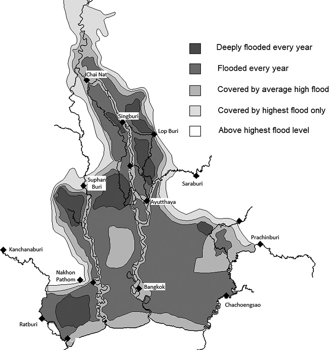
Details of the flood regime in the Chao Phraya Delta prior to the construction of the Bhumibol (1964) and Sirikit (1974) Dams are not known. However, the entire delta was cultivated with TVs—a term that refers to photosensitive varieties with long stems (0.5 to 1 m for “deepwater rice” and up to 4 m for “floating rice”) and cycle durations (between five and nine months) (Tanabe 1980; Takaya 1986). A map from 1950 (Fig. 1) shows that flooding occurred annually in most of the delta, with the exception of the levees around the river and main canals, the coastal zone, and a few higher-elevation areas.
II-2 The Greater Chao Phraya Irrigation Scheme of the 1960s and 1970s
The water regime in the Chao Phraya Delta has been in a state of constant change over the last 60 years, in line with gradual land development and the “artificialization” of the natural landscape and hydrological regime. The introduction of the Greater Chao Phraya irrigation scheme in the 1960s and 1970s saw irrigation canals built on the natural levees bordering the waterways and water controls increased on the higher land served by these canals (Small 1972), enabling double cropping.
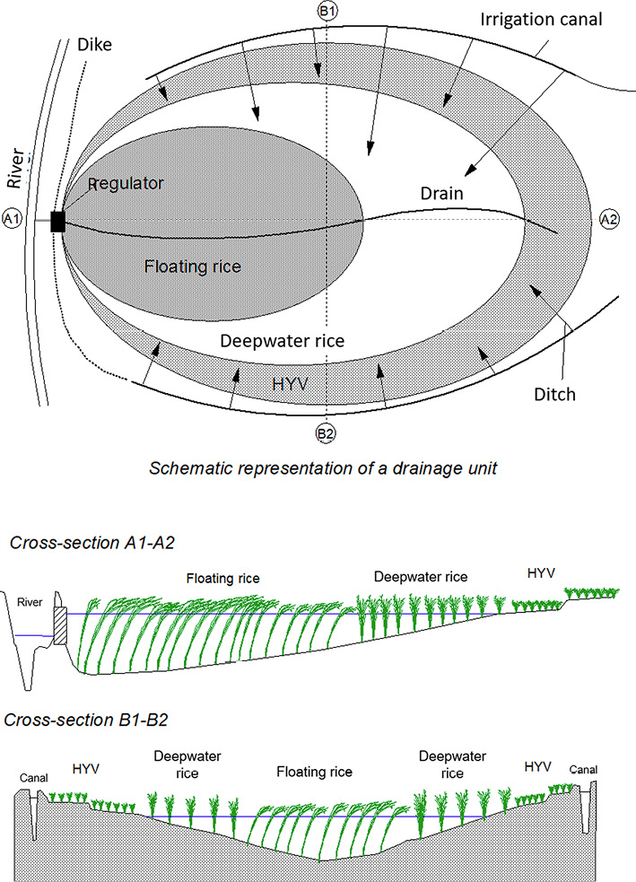
However, low-lying areas in the upper delta remained vulnerable to flooding caused by a combination of excess flow from the river system, streams originating on the sides of the delta, return flows from higher irrigated land, and local rainfall. To better regulate the flood pattern in terms of height and duration, dikes were built around the (lower) part of these “drainage boxes” (Molle et al. 1999) with regulated outlets to the rivers. (Fig. 2 shows the general structure of a drainage box.) In the 1970s, most of the floodways through which the Chao Phraya River could spread into low-lying areas were gated and closed. Following the floods of 1975, for example, the embankments were raised 50 cm above the flood level. By the late 1980s, around 500,000 ha of traditional rice varieties were still cultivated in the Chao Phraya Delta (Puckridge et al. 2000).
Thus, a system of 20 main drainage boxes was gradually constructed and improved in the upper delta. (Fig. 3 shows the name and main outlet of each of these boxes.) It allows water to accumulate within the boxes to a suitable height and retains it at that level until the rice ripens, at which point it is drained for harvesting. This takes place in December or January, depending on the box, once the water level in the river system outside the boxes has subsided, allowing water to be drained by gravity. The drainage rate depends on the box (topography, design of outlet sluices, rice variety, etc.). If there is a single variety, quick drainage is required for harvesting. Where there are several, those growing lower down usually need water for a few days longer and the drainage rate is slower. The rate also depends on downstream conditions in the river. These are affected by the inflow into the delta and the drainage of other boxes. Fig. 4 shows the drainage curves of the three regulators located on Khlong Bang Phra Khru draining the Bang Kum box following the opening of the gates around December 12. We see that the upstream regulators raise the water level, delaying the drainage of those farther downstream.2)
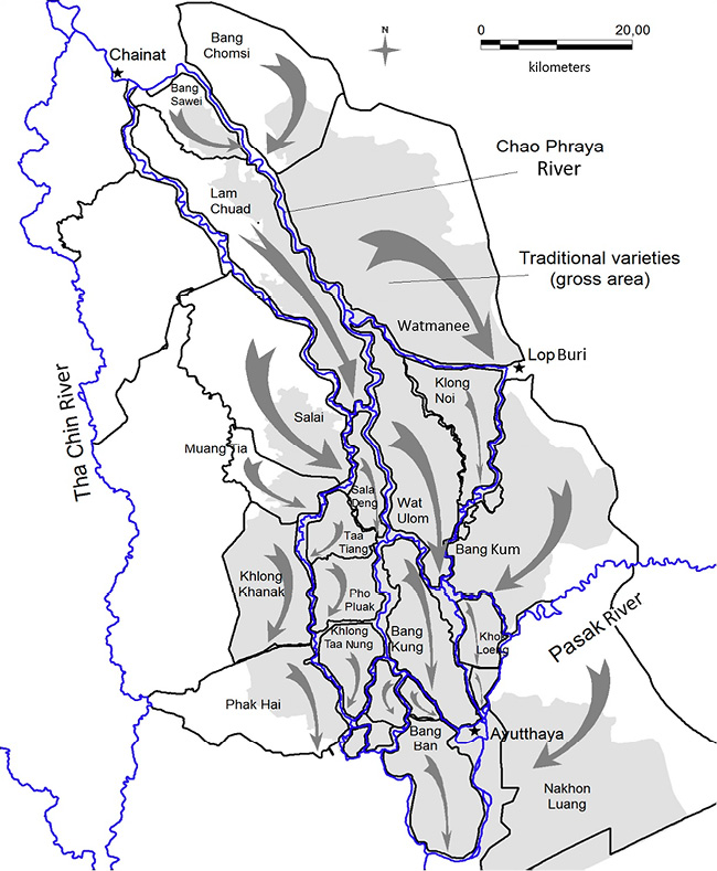
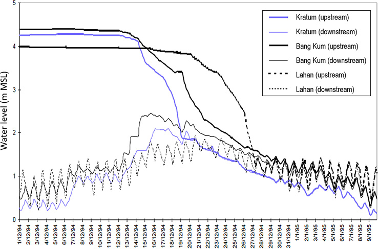
Fig. 4 Drainage of the Bang Kum Box 1994–95 (Three Outlets)
While boxes allow a degree of control, risk is not fully eliminated. High inflow can exceed the drainage capacity of the boxes, leading water to rise above normal levels and submerging some deepwater rice varieties. If the inflow is too weak, it can cause the water level to rise too slowly or not high enough. A delay in draining the box can force farmers to harvest their rice by boat. Higher land tends not to flood and can be irrigated by canals and cultivated with HYVs. Depending on the year, location, and water availability it can even be double-cropped.
III The Wholesale Shift from Traditional Rice Varieties to HYVs
III-1 The First Wave of Change
The construction of the Bhumibol and Sirikit Dams, as well as the development of smaller dams and diversion works in the upper and middle sections of the Chao Phraya basin, decreased the intensity of flooding (see Molle et al. 2001a; Tebakari et al. 2003). This first manifested itself in the lower delta, where flooding was on average far less severe. Farmers in the upper half of the West Bank (Chao Chet Bang Yihon and Phraya Banlue Projects) found that they could afford to partly protect their fields from flooding by building dikes. Raised road embankments also helped to polder fields from the many waterways that crisscross the West Bank (Takaya 1986; JICA 1992). Where the risk was too high, calendars would be shifted in order to cultivate before and after the flood period. In the West Bank, but also in the East Bank, these changes led to the disappearance of TVs (Tanabe 1980). The availability of water during the dry season (from the Chao Phraya Dam and pumping from adjacent rivers) enabled farmers not only to shift to more productive HYVs but also to double-crop their fields, with substantial economic gains.
In the late 1980s improved water control in the Mae Klong basin3) also reduced flooding along the Song Phi Nong River, which marks the divide between the Mae Klong alluvial fan and the paddy fields of Suphan Buri to the west of the Chao Phraya Delta. While Song Phi Nong used to be famous for its semi-aquatic lifestyle, with locals living on the first floor of their houses and using boats during the flood period (see Sumet 1988), farmers found that the reduction in flooding meant they could grow one HYV before the flood and another after, as in the West Bank.
From the mid-1980s to the end of the 1990s, several drainage boxes of the upper delta underwent similar changes in their regulation (Molle and Jesda 1998). First, the level was reduced in the flood period as the intensity of flooding appeared to lessen, due to an overall decline in inflow and the development of intermediate cross-regulators on the boxes’ main drains that allowed greater, stepwise control of the water. The development of on-farm infrastructure on the high lands gave better access to irrigation water from canals, and the spread of individual axial pumps allowed farmers to tap low water from canals, drains, and rivers, facilitating the cultivation of HYVs, which in turn required a lower water level in the box (Molle et al. 2001a).
Second, the target water level at the end of the draining of the box and the beginning of the dry season was increased. As fishing was an important complement to local livelihoods, in the past the boxes were fully drained in order to catch fish more easily in the depressions. However, the target regulation level was raised as dikes were built along both sides of the box main drains, where the remaining water could be stored for use in gardening in the villages or the cultivation of nearby fields, and also perhaps as a result of reduced interest in fishing. Changes in regulation were quite substantial in boxes such as Lam Chuad (from 4 m to 5.5 m), Watmanee (2.3 m to 4.5 m), and Sala Deng (2.5 m to 3 m) (Molle et al. 1999).
But shifting from TVs to the double cropping of HYVs on higher land that is no longer flooded comes with two preconditions: first, the terrain must be leveled and supplied by a water distribution network, where previously floodwater was simply spread across uneven land. This on-farm investment—shouldered by farmers—was facilitated by the ever-cheaper cost of earth-moving machinery and service. Second, irrigation water must be provided by the RID, especially for the second (post-flood) crop that will grow in the dry season, with hardly any rainfall, although in some boxes farmers resort primarily to local resources, including rivers. Water supply depends on the capacity/willingness of the RID to provide water, but farmers have understood that starting cultivation as soon as possible after the flood (sometimes even draining their individual plot by pumping in order to start land preparation early) has two advantages. First, they benefit from the residual soil wetness and water stored in the canals; and second, it compels the RID to supply them with water in the latter stages of cultivation, as the sight of drying paddy fields in media releases is considered unpalatable.
III-2 The Conversion of Drainage Boxes
Despite the transformations discussed above and the overall decrease in the regulated water level in the boxes, by the turn of the century TVs in the delta still occupied around 300,000 ha (Molle et al. 1999). It was, then, hardly envisioned that this remaining flooded land could be converted to HYV double cropping. On the one hand, excess water (from local rainfall, lateral drains entering the delta, return flows from irrigated areas) had to go somewhere, and when the rivers rose to high levels they could not be drained out of the boxes (in the absence of pump stations). On the other hand, the RID was loath to see the demand for dry-season water increase when the supply could irrigate, on average, only around half the delta (Molle et al. 2001a). Yet, despite these limitations, most boxes saw their rice patterns transformed around 2010.4) Below, this is illustrated by the case of the Bang Kum drainage box (BKB).
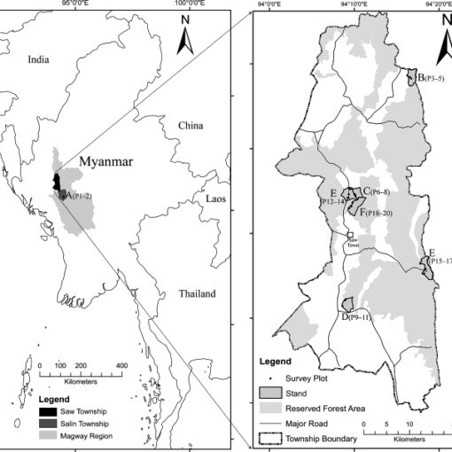
The BKB covers around 83,000 rai, of which 38,000 belong to the Roeng Rang Project and 45,000 to the Kok Katiem Project. Administratively the BKB comprises 22 tambon (subdistricts) belonging to three provinces (Lop Buri, Ayutthaya, and Saraburi) (RID 2018) (see Fig. 5). Ninety percent of the land is used for rice and the rest for taro, other crops, fishponds, small-scale factories, government buildings, temples, and residential areas (RID 2010). The land elevation in the BKB averages 2.9 m (above mean sea level), varying between +2.7 m and +3.2 m (RID 2010).
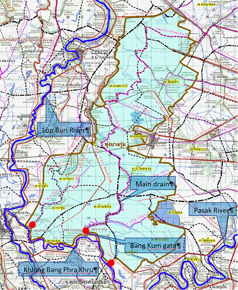
Fig. 5 Bang Kum Drainage Box (BKB), with Regulated Outlets (Round Circles Points)
Source: RID (2018).
At least in the BKB’s lower parts, farmers have been limited by the floodwater regime. Although this regime was regulated, as described above, and therefore afforded a degree of predictability and stabilization of production, yields remained low, at an average of 35 thang (0.35 tons) per rai. The main varieties included the Khao Tah Heng and Pin Kaew 56 (floating rice) varieties (Molle et al. 1999). Farming system analysis in the village of Ban Nong Mon (Molle et al. 2001b) in the heart of the box in 2000 revealed in particular low rice productivity and limited diversification, as well as many absent villagers renting their land to relatives or other villagers, fewer children (due to a lack of economic prospects), a high rate of emigration, and significant off-farm income. A comparison with two other villages, one in Lop Buri Province and the other in Suphan Buri Province, with cropping intensities of 1.45 and 2.9 respectively, showed that the average net income of 822 baht/rai observed in Bang Kum was much lower than the values observed in the other two villages, 2,560 baht/rai and 7,195 baht/rai respectively. Although this stark per rai productivity gap was partly bridged at the household level because Bang Kum had smaller families, larger farms, and a higher reliance on non-cropping activities, off-farm work, and remittances, the per capita income in Suphan Buri remained twice as high as in Bang Kum (yet remarkably far from the initial ratio in land productivity, which was close to 8). This confirmed that environmental constraints to intensification resulted in lower household incomes.
In the late 1990s the RID and provincial services attempted to develop secondary local water resources so farmers could grow a second crop of rice in the dry season, just after harvesting. They excavated ponds surrounded by huge dikes in the lower part of the boxes, but this did not lead to double cropping as the second crop faced three obstacles (Wuttitchai 2000): the limited time window (January to April), which could be reduced by a late flood recession; the need to pump water over high dikes (incurring costs); and the need for collective action (farmers starting alone would see their crops devastated by rats, which had little to feed on in the dry season).
As in the cases of the Upper West Bank and Phak Hai Project, the overall average decline in floodwater inflow during the rainy season became increasingly evident in the BKB, where the target water level was reduced from 4.8 m to 4.5 m in the early 1990s, allowing higher plots to avoid flooding and grow HYVs with water from irrigation canals. In 1995 two farmers from Ban Nong Mon in the BKB attempted dry-season cropping of HYVs but had their fields overrun by rats, followed by flooding. A farmer leader’s attempt at dry-season cropping met with success in 1997—but his fields were located on the higher fringe of the BKB, so he could get irrigation water from the canal.
Collective action was initiated in the 2000s toward a radical, box-wide change in water regulation and rice-cropping patterns. In 2002 a group of farmers in the lower BKB invested 2.8 million baht of their own savings to dig nine ditches with parallel dirt roads, and collectively organized the water management (RID 2010). Their initiative was rewarded with 22.5 million baht from a bumper rice crop that year. The success led them to form a Water User Group consisting of 84 members with 4,700 rai. They invited government agencies from various sectors to discuss abandoning flood-season rice cropping of TVs in favor of the double cropping of HYVs—one crop before the flood and a second after it.5) The RID backed the initiative. Pressure for change mounted when rice cropping became extremely attractive, as the government took to subsidizing production. In 2008–13 the average farm gate price reached 9.6 baht/kilo against a commonplace value of 6–7 baht (OAE, various years).6) If we take the total cost of production of one rai of HYV at 3,600 baht (Stuart et al. 2018) and a yield of 0.85 tons, this hike actually represents an increase in net income by a factor of 2.4.
Neighboring farmers in one area would come together to build a channel to their plots. However, on land that sloped gently toward the central drain, higher plots were hard to reach. Farmers would either have to build two or more consecutive reaches, pumping water from the lower to the higher in stages, or raise the water level from below by operating the gate accordingly. But the latter would cause low-lying plots near the drain to flood, and indeed conflict arose between the owners of low- and high-lying plots (RID 2018, 36–37). Low-lying plots were surrounded with higher bunds to allow a target water level in the box of +3 m so water could penetrate inland through networks of ditches dug by farmers. In order to reach higher land, the target level was gradually increased to +3.2 m once lowland farmers had improved their plot bunds and roads and dikes had been raised and strengthened.
The draining of the box was also contentious, as growers of TVs harvested their crops in late December/January, thereby sometimes delaying the sowing period for the farmers of HYV rice to late January or mid-February. The RID attempted to resolve disputes by holding meetings for farmers to convince the TV growers of the benefits of shifting to two HYV crops and “do[ing] away with old farming habits” (RID 2010, 3–10). It was finally agreed, and in 2010 the RID altered the water regime, replicating what had just occurred in the Watmanee box in the same Kok Katiem Project.
The shift to double cropping entailed a redefinition of the flood-management regime as it had been practiced over previous decades. During the flood period the BKB would now be drained as allowed by the water level in the downstream Khlong Bang Phra Khru (Fig. 5). When the level rose in that canal (which connects the Lop Buri and Pasak Rivers and therefore reflects their respective water levels and flow conditions), the gates would be closed and water would accumulate in the box. There would be no specific attempt to store water, but—as during Phase II—if need be, water could be stored up to 4.5–4.8 m without disrupting local life. As soon as river levels downstream allowed, the gates would be reopened and water drained out of the box. Some years this could be done as early as November, allowing the post-flood crop to be established early, thus maximizing the chances of a second crop the following spring.
However attractive on paper, the new dynamic was not without its limitations, as mentioned earlier with regard to higher-elevation land. TVs were cultivated on rough and uneven ground that was ploughed and sown only after the first rains, usually in April or May. Neither the early rain-fed growth nor the later flooded stages required particular land leveling. But the cultivation of HYVs required investment in farm infrastructure, such as that undertaken by the 84 farmers of the BKB in 2002. This included access roads, plot leveling, and bunds and a network of channels to convey water to inland plots from the low-lying drains and depressions where it was stored.
Despite these investments, eased by the availability of machinery or the possibility of using their four-wheel tractors to grade the land, farmers quickly harvested the benefits of the transformation. From a low benefit estimated at around 1,400 baht/rai for traditional varieties, the double cropping of HYVs yielded7) the handsome sum of 9,100 baht/rai to those who managed to double-crop (for a price of 9.6 baht/ton).
III-3 The “Monkey Cheek” Project and the Requalification of Flood Management
On September 20, 2016 Deputy Prime Minister Gen. Chatchai Sarikulya endorsed—as earlier governments had—the “monkey cheek” (kaem ling) policy, by embracing the use of low-lying land as a buffer at times of flooding (Thanaporn 2018). The move was likely prompted by a very late rice harvest in 2016, which prevented the boxes from being used and shifted the excess flow to the main stem of the Chao Phraya River, damaging houses in Ayutthaya (Bangkok Post, October 11, 2016; RID 2016). Gen. Chatchai Sarikulya issued a ruling that established a cropping calendar intended to accelerate crop establishment and harvesting in 13 areas, termed “monkey cheeks,” in the Chao Phraya basin, including the BKB.8) The new cropping pattern was trialed in 2017, and on May 1 the RID began distributing water for rice cultivation in the 12 monkey cheeks located in the delta (1.15 million rai). The plots were harvested in August and early September before the land was purposely flooded (officially on September 15) so as to store water in line with the new policy. Once filled, the drainage boxes were drained at the beginning of December (officially on December 1).
The shift from the management regime of the early 2010s brought several changes. While still aimed at enabling two crops of rice, it required more formal planning of the cropping calendars within the box so that cultivation (before September 15) and flood mitigation (after September 15) did not conflict. It also required the box to be filled to its full capacity and enforced a no-cultivation period of 2.5 months to allow for fishing. In exchange, the RID committed to sending water in both early May (so harvesting could take place before the flood) and the dry season (from the beginning of November once the flood had receded), while farmers would be compensated if their crops were damaged by an early flood in August.
IV Management and Technical Complexities of Rice-Water Relationship
The changes described in the preceding section allow us to identify four main phases in the development and management of the floodplain. These are summarized in Table 1. Each of these phases corresponds to a major shift in the water management regime. The water regime established around 2010 (Phase III), briefly described above, allowed a spectacular shift from one TV to one or, increasingly often,9) two HYVs. However, the new regime was complicated by a dependence on hydrological conditions both locally and in the upstream areas where the flows that traverse the delta originate. Enhancing local benefits made it necessary to reshuffle the water regime, but this created disbenefits in other parts of the delta. We first examine how such negative externalities were created and later turn to briefly analyzing the most recent promotion of the kaem ling policy (Phase IV) (subsection IV-3).
Table 1 Main Phases in Floodplain Management
IV-1 Juggling Water and Time
Under optimal conditions, that is, in a year not hampered by excessive flooding in the wet season or water shortage in the dry season, this new regime (Phase III) in the BKB could be described as follows: during the potential flood period, typically mid-September to mid-November, water would either be drained or stored when downstream river conditions did not allow drainage. There was no need to store a specific amount of water above that required for the next cultivation season thanks to that stored in the drain, at a set level of around 3.2 m above mean sea level. The duration of the flood period in the BKB depended on a combination of local rainfall, sideflows, and possible excess water in the delta (relieved by diverting water to drainage boxes10)), as well as whether the water levels farther down the river needed the BKB outlets to be fully closed.
As the water receded, sometime in mid-November to December,11) the box would be partially emptied. Farmers would then begin preparing the land without delay on soil still saturated with water, which facilitated ploughing and puddling, and saving the water needed to soak the soil before these operations.12)
However, with rice gradually established across the BKB and irrigated with water stored between the dikes of the main drains, the available levels quickly declined. The extent to which crops can be established (particularly on higher ground, far from the central drain), and the time taken for this, thus depend on additional supply, which can come from several sources (Fig. 6):
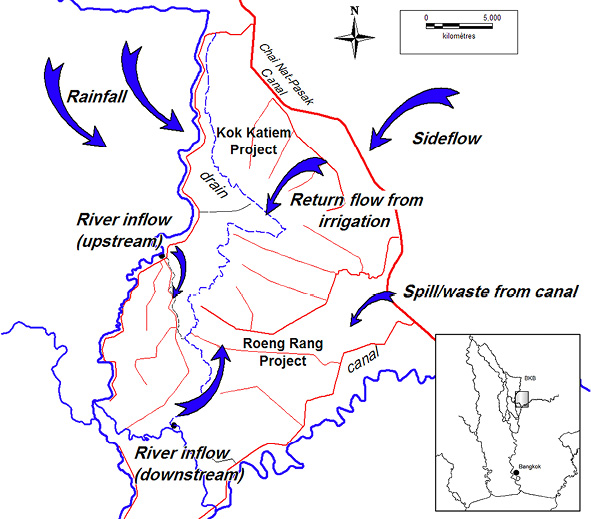
1. Released from Chai Nat-Pasak feeder canal by the RID through secondary canals or drains to supply the BKB
2. Pumped from the Lop Buri River and Khlong Bang Phra Khru to meet irrigation needs, including permanent pumps set up by subdistricts or farmers themselves, and mobile RID pumps in case of crisis
3. Local storage either in excavated natural ponds (bung) or dug reservoirs, both of which can be fairly large in certain boxes, such as Lam Chuad and Wat Ulom. In the BKB the army has recently excavated a buffer reservoir with local funding.
4. Return flow from the higher areas in the Roeng Rang and Kok Katiem Projects that receive canal water and irrigate by gravity (from both canal tail-ends and the drainage system), but these areas generally receive water later (and may be allocated very limited water, depending on the year).
A major consequence of the new regime that must be emphasized is that by allowing farmers in the box to forego their TV and cultivate after the flood recedes, the RID has implicitly put itself in the position of having to ensure supply to the area once local resources are exhausted. Since the overall availability of water—at the basin or delta level—is very limited in the dry season, and although the BKB partly grows its post-flood crop based on local water resources, this creates added competition between upstream highland farmers (who receive water by gravity through the canal system) and lowland farmers in the box.
Indeed, the optimistic planting of rice after the flood can be confronted by a lack of water toward the middle or end of the cycle. This leads to desperate measures on the part of farmers, as in the BKB in 2015, when 40 pumps were pooled to extract water from the bottom of the BKB main drain13) (see Fig. 7), compelling the RID to find ways to support paddy fields in want of water so as to avoid damaging media coverage of withering crops. (This included pumping water from the Lop Buri River and Khlong Bang Phra Khru [see Fig. 5] with mobile pumps and allowing extra releases from the Chao Phraya Dam.) But losses in yield are not always preventable: in March 2016, 400,000 rai were damaged in the delta.14)
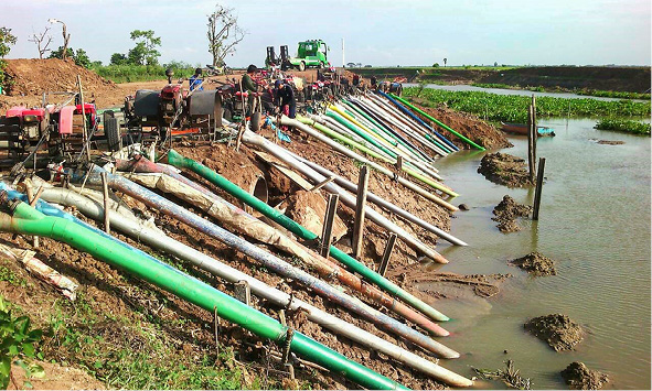
Fig. 7 Farmers Collectively Pumping the Remaining Water in the BKB Main Drain (2015) (Khun Somboon, Ban Nong Mon)
Therefore, in 2019 and again in 2020, low or uncertain stocks led the RID to announce at the beginning of the year that farmers should not cultivate dry-season crops, as the water supply could not be assured. The move was intended to renounce responsibility and prevent any criticism of the RID should crops fail. Yet, despite the warnings there were reduced yields and even crop loss, demonstrating that in practice it is not possible to prevent farmers from embarking on cultivation if they have access to water.
Around three to four months after sowing, depending on the rice variety used and access to water,15) fields in the box are drained in order to allow mechanical harvesters to operate. Farmers in the higher parts of the box, who have to pump water from below to irrigate (unless it reaches them from above, through the canal system), now benefit from their plot’s position and drain by gravity. Conversely, farmers on lower land—below the regulation level of 3.2 m—who can get water from the main drain into their plot by gravity sometimes need to pump water out. All such operations are carried out using mobile axial pumps generally powered by two-wheel tractors. It is possible for managers to lower the regulation level (say from 3.2 m to 1.5 m in a week) so all the fields can be drained by gravity, including the lowest. Once this is done, in a matter of days the gates are closed again to allow the water level to recover so that farmers can begin their second crop.
In May, therefore, farmers are eager to embark on a second HYV crop. However, this also may face water shortages, since there is little flow from upstream plots and the rainy season water delivery is only slowly beginning in the basin; the latter can be delayed if rainfall is late and upstream storage dams are depleted. In addition, Roeng Rang Project is fourth in line on the Chai Nat-Pasak Canal, and it takes time before it can receive and divert its full share. Water supply can be enhanced by two natural sources, but these are unpredictable:
5. Local rainfall, which can vary widely at the beginning of the rainy season
6. Rainfall in the rain-fed areas of Saraburi and Lop Buri Provinces, which generates sideflows that traverse the Chai Nat-Pasak Canal through siphons and then the Kok Katiem and Roeng Rang Projects to feed their drainage system and the BKB
As the rainy season unfolds, more water is diverted to both the highlands and the box, the latter also benefiting from the return flow of the former (sources 1 and 4 above). Irregularity in the total supply combined with the nature of the plot (topography, elevation, distance from water sources, etc.) governs two things: whether a particular farmer in the box decides to grow a second crop or not, and when he will be able to do so. Lowland farmers facing limited water supply in April–May may wait for supply to increase later in the rainy season, but the issue then is timing: those sowing their crop, say, at the beginning of June would have to harvest it after mid-September and face the risk of flooding, meaning that some forego cultivation. This creates the counterintuitive scenario of some farmers in the BKB no longer growing rice in the rainy season (Fig. 8).

Fig. 8 Cropping Calendars in the BKB and the Issues Faced (Phase IIII)
Storage is almost always low by the end of the dry season. Indeed, in April 2019 the deputy PM revealed that 23 large reservoirs were below 50 percent of their total water capacity due to releases made to “meet the high water demands in the [Chao Phraya] basin during the rest of the dry season” (Pratch 2019). And the situation can be dramatic if dam storage is extremely low. It can severely delay the establishment of the main crop, meaning the crop cannot be fully harvested if floods arrive in October (or earlier). This was precisely the case in 2016, which followed a year of very limited inflow in 2015 compounded by excessive releases in the dry season and minimal rainfall and runoff at the beginning of the rainy season. By the end of September 750,000 rai had not yet been harvested,16) and the RID delayed the sending of excess water to drainage boxes, creating tension with the governor of Ayutthaya, who demanded that pressure be relieved for those living outside the dikes.17)
Served by gravity irrigation canals, higher land faces a different set of constraints and a different calendar. Here farmers usually start rainy-season cultivation in June or even later, harvest after the main rainy period, and await supply from the RID in January or later to grow a second crop.18) This crop is therefore conditional upon water availability in the delta and Chao Phraya basin.19) Return flow benefiting BKB farmers also depends on the extent and timing of double cropping upstream. Such contingencies can be alleviated by growing shorter-term rice varieties (between 85 and 105 days) or exploiting local reserves (private or public ponds and reservoirs). But a 2,000-rai area located at the end of Kok Katiem’s Canal 21, which follows the left bank of the Lop Buri River and ends up in the BKB, illustrates the issues. The downstream fields receive water very late in the dry season (as upstream farms abstract water from the canal first and also because priority is given to BKB lowlanders), and therefore they are commonly not harvested until the end of June. Since the risk of flooding is high, farmers here prefer to use traditional varieties (deepwater rice) for the ensuing wet season. Hence, the shift from TV to HYV in the lowlands, and the priority lowlands were given, limited the supply and delayed delivery to an area that had to go back to TV in the rainy season!
This detailed description of the constraints on growing two crops in the BKB (summarized in Fig. 8) serves to show that intensification (a shift from TV to HYV and from one to two crops) comes with a higher risk in a context where the control of water flows remains partial.
IV-2 Impact of Phase III on Land and Water Resource Use
The shift in rice cultivation observed in the BKB brought a radical leap in land productivity. The average output per hectare grew from 1–2 tons in the 1990s to up to 10 tons where two crops could be grown. However, this came at the cost of more chemicals sprayed on fields that had once received only natural silt. On the other hand, the creation of an almost permanent wetland in the box bottom boosted fish stocks and attracted a spectacularly high number of birds that preyed on fish.
In the Roeng Rang and Kok Katiem Projects the shift has substantially increased the efficiency of water use since return flows from higher land are collected by the drainage system and reused in the BKB. Gates remain closed most of the year, and this is particularly clear in the dry season, when no water is lost (with even some inflow gathered at high tide). In the rainy season water efficiency is less of an issue since natural runoff generally exceeds agricultural demand. Reservoirs excavated in the box capture some wet-season water to be used during the dry season and therefore also raise water use efficiency.
Effective communication increases efficiency too. The RID organizes one or two meetings a year (attended by 200–300 farmers from eight amphoe/districts) in Don Phut, in the middle of the BKB, to agree on cropping calendars and regulatory targets. RID staff also visit local authorities to coordinate the communication of the new water management approach to communities. This includes the use of the mobile phone application Line, via which farmers are informed of the daily water level at key locations.20)
Since the RID gave all farmers in the Roeng Rang and Kok Katiem Projects the opportunity to double-crop, they have been able to increase their income (see subsection III-2). However, at a wider level, that of the basin, this agricultural intensification is highly problematic. By allowing the shift in farming practices across the whole delta’s floodplain, the RID substantially increased the overall water demand in the dry season. With more diversions to irrigation projects and no return flow to the river system, less water is available to sustain the river flow and, eventually, the Chao Phraya River at its estuary.21) The growing abstraction of water from Khlong Bang Phra Khru and the Lop Buri River (and elsewhere from the Noi and Tha Chin Rivers) has also reduced river flows. All this worsens the chronic problem of saline water intrusion that periodically affects the lower delta in dry years (and threatens, for example, durian and other fruit orchards in Nonthaburi and even the main intake of Bangkok’s domestic water supply).22)
The shift also has mixed implications for flood management. On the one hand the filling of the box, which is left to depend on hydrological conditions, represents an optimal kaem ling flood management strategy, with boxes filled as late as possible to absorb any forthcoming excess. On the other hand, though, the BKB can now be under cultivation at a time (say, late September) when (in Phase II management) the box would already be absorbing early excess water that would gradually flood and sustain traditional varieties. The late presence of crops in the BKB is due to the increased staggering of rice cropping, as farmers try to adapt two crops to an uncertain water supply environment (the six sources identified above) while sharing water at the local level (Fig. 8). In other words, farmers cannot establish their crop at the same time because of the time needed to distribute water spatially.
The limited ability to absorb early water excesses has both local and broader consequences. Since no excess water can be sent to the BKB (or other boxes) before crops are harvested, the RID is obliged to block incoming sideflows by closing the siphons that traverse the Chai Nat-Pasak Canal. This causes flooding along the eastern embankment, which must then be dealt with through pumping ponding water into the Chai Nat-Pasak Canal itself. Across the delta the late cultivation of the boxes prevents the RID from making use of them and concentrates excess flow in rivers, which is problematic for people residing outside of the dikes, as illustrated in Ayutthaya in 2016 (described above). In summary, when scaled up to the level of the delta the local reshuffling of the water regime in the different boxes generates externalities at other scales.
IV-3 Impact of the Kaem Ling Policy in Ayutthaya (Phase IV)
The early flooding in Ayutthaya led the government to float a policy in late 2016 seeking to establish a fixed calendar to prevent late harvesting in drainage boxes. However, the complexity of the situation described above, with multiple cropping calendars varying in space and time according (mainly) to access to a diversity of (also varying) water resources, cannot be simplified and made uniform without a loss of flexibility and negative consequences.
The regulation shift achieved in the late 2000s (Phase II) saw improvements in flood management. Indeed, keeping the drainage boxes as empty as possible by releasing water at every opportunity maximizes their buffering capacity. This added capacity varies greatly since it depends on whether the boxes are filled naturally or from diverting irrigation canals—a complex and fluctuating process. The new policy (Phase IV) came with four potential negative impacts.
The first was that buffering capacity in the boxes was reduced with the introduction of the “Release water in plots, release fishes in lowlands” project23) by the governor of Ayutthaya in association with the Department of Fisheries, the RID, and the MOAC. The new policy would enforce a fixed calendar, whereby farmers would have to harvest before September 15 (or a similar date) so that boxes could be filled, but then the RID would start filling them even when it was not necessary. This would reduce the buffering capacity that could be needed later in October, depending on future hydrological events and patterns.
Second, the policy of filling the boxes to capacity actually reverts to the water management mode of the 1990s (Phase II), except that no rice is now cultivated in the boxes during the flood period. The process brings in fertilizing silt, kills weeds, and allows fish to grow—and villagers to catch them—benefits emphasized by the local authorities of Ayutthaya. Records show that in four of the past five years the water level inside the BKB peaked above 4 m, despite the policy of minimizing the levels in the boxes. This means that the control of weeds and the inflow of silt are partially achieved by the Phase III management. Filling the boxes to capacity, whether necessary or not, also reduces the average buffer capacity. This is ironic since the policy is promoted under the kaem ling banner as a flood-mitigation strategy.
Third, the policy is to keep water in the boxes for 2.5 months. While this extension enhances fish production, it may delay the emptying of the boxes and therefore the establishment of the post-flood crop or prevent the cultivation of a second HYV crop in the box altogether.
Fourth, as well as flood management the policy promotes double cropping, thereby increasing the demand for water in the dry season. Phase III made double cropping possible, but it was mostly left to farmers to find the water to grow the post-flood crop (although the RID was at times forced to supply some to avert crop loss). In a bid to gain farmers’ acceptance, however, the new policy includes priority water supply to the farmers in the kaem ling boxes in both the dry and early wet seasons, ensuring that they can harvest on time (mid-September). This increases water demand as well as encourages farmer complaints when the promised water is not delivered.
Another incentive included in the policy is the government’s commitment to compensating farmers if early flooding damages their crop, on the condition that they register their land. The outcome of this, according to one local official, is that farmers have been tempted to register far larger cropping areas than they actually have.
It remains unclear whether this policy has in fact been implemented in the BKB as it has in the boxes near Ayutthaya (Bang Bal and Phak Hai Projects) and Bang Rakam in Phitsanulok, which are monitored more closely and may have a more direct impact on reducing water levels in the Chao Phraya River. Local residents appear unconcerned, explaining in particular that Ayutthaya’s governor cannot impose the policy here because half of the BKB lies in Lop Buri Province.
V Discussion and Conclusion
The history of rice intensification over the past three decades in the floodplain of the Chao Phraya Delta in general, and the Bang Kum box in particular, shows how a trend that began in the late 1980s and 1990s in the less flooded areas of the lower delta took hold across the delta. The shift from one TV to the single/double cropping of HYVs was made technically possible by several factors, ranging from ever-increasing storage and diversion capacity in the upper Chao Phraya basin (reducing the average flood pattern24)), increased availability of secondary sources (drains and ponds in low-lying areas, excavated reservoirs, pumping from rivers, etc.), and elevated roads to technological advances (mechanized farm processes, the availability of short-cycle rice varieties, etc.) (see Molle et al. 1999; 2001a).
But the shift also indirectly resulted from the government’s policy to support rice prices (Ricks 2018). The delta’s floodplain had long been known for its aging farmers, smaller families, and high rates of tenancy (near Ayutthaya) (see Molle and Thippawal 1999), and a comparison of farming systems in three areas with contrasting cropping intensities in 2000 showed that low rice incomes forced villagers to migrate and/or work off-farm (Molle et al. 2001b). It is, therefore, understandable that windfall profits from rice due to a rise in prices encouraged farmers to act collectively and to coordinate with the RID to implement a full-fledged change in water management. Farmers who could, after investments in on-farm infrastructure, achieve a double cropping of HYVs could multiply their rice income more than sixfold. Although no in-depth research was conducted in the BKB after the changes, the authors’ two visits to Ban Nong Mon in 2018 provided some striking visual hints of the new wealth of the village since the survey conducted 20 years earlier. Water use efficiency has also substantially increased in the projects thanks to local storage and the recycling of return flows.
It is not fully clear why the RID abandoned its policy to discourage the expansion of dry-season water demand. One reason might be that the 1987–2000 period, when Phase II management prevailed, was shown in retrospect to be a period with low dry-season water availability. In contrast, the 2000–11 period can be considered “wet”: the amount of water released by the Bhumibol and Sirikit Dams between November and April (the dry season) in the 2007–11 period, during which prices were raised, was 8.5 billion m3, against 6.6 billion m3 for a median year before 2000 (Molle et al. 2001a). During the same period, the average area irrigated in the dry season in the delta was 5.8 million rai, versus 3.1 million rai during the 1900s (OAE, various years). Another reason is that changes in management were negotiated largely at the project level, without considering wider implications at the delta or basin level. If such considerations were mentioned, they were probably pushed aside in the face of social and political pressure in favor of expanding rice cultivation.
The most fascinating finding of this research is perhaps the interconnectedness of diverse areas through the water regime, and the cross-scale impacts of changing water distribution and cropping patterns. Water availability depends on a number of factors, some natural (rainfall—both local and in the upper basin—sideflows, dam inflow) and some manageable (dam releases, scheduling, allocation, etc.). The combination of these depends on and also shapes complex and fluctuating hydrological patterns. Farmers set their crop calendars by weighing risk and uncertainty and taking into account local conditions (topography, equipment, mix of accessible or potential water sources, price of rice, etc.). But particular choices at the local level, when combined, have implications for water allocation and flood management at the delta/basin level. Notwithstanding the local benefits of the broad shift to double cropping, the floodplain of the delta has experienced some macro-level negative impacts.
The first is increased water demand in the dry season that results in competition over the resource and reduced return flow to the river system. As we have seen, this competition occurs between uplanders and lowlanders but also at a wider scale, since water allocation in the dry season resembles a zero-sum game (Molle et al. 2001a). The spread of dry-season cropping over the 300,000 ha of floodplain therefore means that the water used to fuel this expansion has to come from somewhere else: there will be more saline intrusion into the Chao Phraya and Tha Chin Rivers, areas elsewhere in the basin will be deprived of water, groundwater elsewhere will be increasingly depleted, or more water will be released from the dams. This last outcome may reflect increased water storage, like in the 2000s, but it can also reflect carelessness: more water is released during the dry season, at the cost of increased risk in case dams do not fill up again quickly at the beginning of the ensuing rainy season. This is what was observed in 2019 and 2020, for example.
The second cross-scale disturbance brought about by the shift to HYVs was the constraint not to flood the drainage boxes before they were harvested. This loss of flexibility in flood management resulted in unusual early flooding near Ayutthaya and flooding along the Chai Nat-Pasak Canal, as sideflows could not be allowed into the delta.
The policy implemented in 2017 was justified by its aim of avoiding such problems and restoring a degree of predictability to cropping calendars. Yet it seems to have been devised without a full understanding of water management in the delta’s floodplain. The introduction of fixed calendars would reduce management capacity, add rigidity where flexibility was required, and shift the risk from farmers (who adjust to the water regime) to the RID (which committed to supply them). Ironically, the policy was devised under the banner of the monkey cheek policy while actually undermining an existing system that was close to an optimal monkey cheek strategy. This complexity is not easily comprehended, which is why a form of adaptive management that favors flexibility and risk-taking at the farm level is preferable to a top-down approach that attempts to freeze crop calendars within a fluctuating and unpredictable environment. Although the strategy has been implemented in Bang Rakam, near Sukhothai, and in other drainage boxes of the delta, it seems that its practical implementation in the BKB, and possibly elsewhere, will prove unviable.
Accepted: September 4, 2020
Acknowledgments
The first author would like to warmly thank the Center for Southeast Asian Studies, Kyoto University, for the scholarship extended to him and during which this paper has been written.
References
Apinya Wipatayotin; and Sunthorn Pongpao. 2016. Province, Irrigation Dept at Odds over Floods: Ayutthaya Is Urging “Immediate Action.” Bangkok Post, September 27. www.bangkokpost.com/thailand/general/1095713/province-irrigation-dept-at-odds-over-floods, accessed March 1, 2020.
Bangkok Post. 2016. Farmers Brace as River Water Diverted to Farms to Ease Floods. October 11. http://www.bangkokpost.com/thailand/politics/1107369/farmers-brace-as-river-water-diverted-to-farms-to-ease-floods, accessed March 1, 2020.
Biggs, David; Miller, Fiona; Chu Thai Hoanh; and Molle, François. 2009. The Delta Machine: Water Management in the Vietnamese Mekong Delta in Historical and Contemporary Perspectives. In Contested Waterscapes in the Mekong Region: Hydropower, Livelihoods and Governance, edited by François Molle, Tira Foran, and Mira Käkönen, pp. 203–225. London: Earthscan.
Boserup, Ester. 1981. Population and Technological Change: A Study of Long-Term Trends. Chicago: University of Chicago Press.
Catling, David. 1992. Rice in Deep Water. London: International Rice Research Institute and Macmillan Press.
Chularat Saengpassa. 2016. Water Crisis Turns Acute. The Nation. March 21. www.nationthailand.com/news/30282062?utm_source=category&utm_medium=internal_referral, accessed March 1, 2020.
De la Loubère, Simon. 1986 [1693]. A New Historical Relation of the Kingdom of Siam. Bangkok: White Lotus.
Gervaise, Nicolas. 1989 [1688]. The Natural and Political History of the Kingdom of Siam. Bangkok: White Lotus.
JICA (Japan International Cooperation Agency). 1992. Study on the West Bank of the Lower Chao Phraya Delta. Bangkok: JICA.
Kaida Yoshihiro. 1974. Pioneer Settlements and Water Control Development on the West Bank of the Lower Chao Phraya Delta: Water Conditions in the Deltaic Lowland Rice Fields (II). Southeast Asian Studies 11(4): 512–524.
Kasetsart University; and ORSTOM. 1996. Identification of Agricultural and Irrigation Patterns in the Central Plain of Thailand: Prospects for Agricultural Research and Development. Bangkok: DORAS Project.
Kono Yasuyuki. 2001. Canal Development and Intensification of Rice Cultivation in the Mekong Delta: A Case Study in Cantho Province, Vietnam. Southeast Asian Studies 39(1): 70–85.
Le Thuy Ngan; Bregt, Arnold K.; van Halsema, Gerardo E.; Hellegers, Petra J. G. J.; and Nguyen Lam-Dao. 2018. Interplay between Land-Use Dynamics and Changes in Hydrological Regime in the Vietnamese Mekong Delta. Land Use Policy 73: 269–280.
Molle, François; and Dao Thê Tuân. 2006. Water Control and Agricultural Development: Crafting Deltaic Environments in Southeast Asia. In A History of Water, Vol. 1: Water Control and River Biographies, edited by Terje Tvedt and Eva Jakobsson, pp. 144–171. London and New York: I.B. Tauris.
Molle, François; and Jesda Keawkulaya. 1998. Water Management and Agricultural Change: A Case Study in the Upper Chao Phraya Delta. Journal of Southeast Asian Studies 36(1): 32–58.
Molle, François; and Thippawal Srijantr. 1999. Agrarian Change and Land System in the Chao Phraya Delta. DORAS Project, Kasetsart University, Research Report No. 6.
Molle, François; Chatchom Chompadist; Thippawal Srijantr; and Jesda Keawkulaya. 2001a. Dry-Season Water Allocation and Management in the Chao Phraya Delta. Research Report No. 8, submitted to European Union, Bangkok. https://horizon.documentation.ird.fr/exl-doc/pleins_textes/divers19-02/010047106.pdf, accessed September 25, 2020.
Molle, François; Sripan Durongdej; Chatchom Chompadist; Joannon, Alexandre; and Yuphaa Limsawad. 1999. Improvement of Rice Cultivation and Water Management in the Flooded Area of the Central Plain of Thailand: A Zoning of Rice Systems by Using Remote Sensing Imagery. DORAS Center, Kasetsart University, Research Report No. 5, submitted to NRCT, Bangkok.
Molle, François; Thippawal Srijantr; Latham, Lionel; and Phuangladda Thepsatitsilp. 2001b. The Impact of the Access to Irrigation Water on the Evolution of Farming Systems: A Case Study of Three Villages in the Chao Phraya Delta. DORAS Center, Kasetsart University, Research Report No. 11, http://g-eau.fr/images/PRODUCTION/Articles_chercheurs/Molle_F/3_Chao_Phraya_Delta_villages_study_R11_DORAS.pdf, accessed September 25, 2020.
Nguyen, Van Kien; Pittock, Jamie; and Connel, Daniel. 2019. Dikes, Rice, and Fish: How Rapid Changes in Land Use and Hydrology Have Transformed Agriculture and Subsistence Living in the Mekong Delta. Regional Environmental Change 19: 2069–2077.
OAE (Office of Agricultural Economics). Various years. Agricultural Yearbook. Bangkok: OAE.
Pallegoix Mgr. 1976 [1852]. Description du Royaume Thai ou Siam [Description of the Kingdom of Siam]. Bangkok: DK Book House.
Pratch Rujivanarom. 2019. Water Situation Worrying. The Nation. April 14. https://www.nationthailand.com/news/30367687, accessed March 1, 2020.
Puckridge, David; Tawee Kupkanchanul; Wilailak Palaklang; and Kalaya Kupkanchanakul. 2000. Production of Rice and Associated Crops in Deeply Flooded Areas of the Chao Phraya Delta. In proceedings of the conference “The Chao Phraya Delta: Historical Development, Dynamics and Challenges of Thailand’s Rice Bowl,” Bangkok, December 12–15, pp. 51–85.
Ricks, Jacob. 2018. Politics and the Price of Rice in Thailand: Public Choice, Institutional Change and Rural Subsidies. Journal of Contemporary Asia 48(3): 395–418.
RID (Royal Irrigation Department). 2018. Karn chai phuen thi lum tam thung Bang Kum phuea rong rab pariman nam laak รายงานการศึกษา การใช้พื้นที่ลุ่มต่ำทุ่งบางกุ่มเพื่อรองรับปริมาณน้ำหลาก [Use of Bang Kum low-lying area for floodwater retention study project]. Water Management Division, Bureau of Water Management and Hydrology, RID.
―. 2016. Drought and Flood Management in Ayutthaya RID. Ayutthaya: RID.
―. 2010. Khrongkarnsueksa phuea karnphattana prasithiphap karnthamngarn tam tuachiwad khamrabrong karnpatibatrachakarn (cho po 11): Raingarn karnsueksa phuea phattana phuen thi lum tam thung Bang Kum โครงการศึกษาเพื่อการพัฒนาประสิทธิภาพการทำงานตามตัวชี้วัดคำรับรองการปฏิบัติราชการ (ชป ๒๒): รายงานการศึกษาเพื่อพัฒนาพื้นที่ลุ่มต่ำทุ่งบางกุ่ม [Study project for the development of work performance according to Statement of Approval indicator (RID 11): Study project for the development of Bang Kum low-lying area].
Small, Leslie Eugene. 1972. An Economic Evaluation of Water Control in the Northern Region of the Greater Chao Phya Project of Thailand. PhD dissertation, Cornell University.
Stiven, A. E. 1994 [1903]. Rice. In Twentieth Century Impressions of Siam: Its History, People, Commerce, Industries, and Resources, edited by Arnold Wright and Oliver T. Breakspear, pp. 144–150. Bangkok: White Lotus.
Stuart, Alexander M.; Pame, Anny Ruth P.; Duangporn Vithoonjit; Ladda Viriyangkura; Julmanee Pithuncharurnlap; Nisa Meesang; Prarthana Suksiri; Singleton, Grant R.; and Lampayan, Rubenito M. 2018. The Application of Best Management Practices Increases the Profitability and Sustainability of Rice Farming in the Central Plains of Thailand. Field Crops Research 220: 78–87.
Sumet Jumsai. 1988. Naga: Cultural Origins in Siam and the West Pacific. Singapore: Oxford University Press.
Takaya Yoshikazu. 1986. Agricultural Development of a Tropical Delta: A Study of the Chao Phraya Delta. Monographs of the Center for Southeast Asian Studies, Kyoto University, Vol. 17. Honolulu: University of Hawai‘i Press.
Tanabe Shigeharu. 1980. Farming Technology in the Deep Flooding Area of the Chao Phraya Delta: A Case Study in Ayutthaya. Southeast Asian Studies 17(4): 658–707.
Tanaka Koji. 1995. Transformation of Rice-Based Cropping Patterns in the Mekong Delta: From Intensification to Diversification. Southeast Asian Studies 33(3): 363–378.
Tebakari Taichi; Yoshitani Junichi; Virat Khao-Uppatum; and Chanchai Suvanpimol. 2003. Trends in Decreasing Discharge in 1970s–1990s in the Chao Phraya River. Proceedings of the First International Conference on Hydrology and Water Resources in Asia Pacific Region, Kyoto, March 13–15, Vol. 1, pp. 185–190.
Thailand, Ministry of Agriculture. 1950. Thailand and Her Agricultural Problems. Bangkok: Ministry of Agriculture.
ThaiVisa. 2016. Drought to Damage Almost Half a Million Rice Fields in Central Plain. March 10. https://forum.thaivisa.com/topic/901818-drought-to-damage-almost-half-a-million-rice-fields-in-central-thailand/, accessed March 1, 2020.
Thanaporn Trakuldit. 2018. Analysis of Public Participation in the Design of Flood Expansion Areas in Nakhon Sawan Province and Phitsanulok Province, Thailand. Master’s thesis, Asian Institute of Technology, Bangkok.
Voogd, Sjoerd. 2019. The Bang Rakam Model: Farmers’ Perceptions on a Flood Retention Policy in Phitsanulok and Sukhothai Province, Thailand. Master’s thesis, University of Amsterdam.
Wuttitchai Chinawong. 2000. Utilisation of Water Reservoirs for Dry-Season Cropping: The Case of Reservoirs in the Flood Plain of the Chao Phraya Delta. MSc thesis, Kasetsart University.
1) The option of constructing large-scale pumping stations to remove that excess water into the river system, as practiced in the Red River Delta, for example, was considered economically unsound at this stage of the development of rice cultivation in Thailand.
2) Note the tidal effect on Khlong Bang Phra Khru, located 15 km upstream of Ayutthaya.
3) Notably with the construction of two large storage dams.
4) The generalization of the shift observed in Bang Kum to the whole floodplain was confirmed by satellite images and visits to six different boxes.
5) Those who helped mediate the process included a former director general of the Department of Agricultural Extension and a head of district with political support.
6) The reasons for this sharp increase in rice prices are beyond the scope of this paper. For further details, see Ricks (2018).
7) Not accounting for the investments made in on-farm development.
8) Twelve were situated in the middle and lower basin, the Bang Rakam low-lying land being the only one located in the upper basin (Sukhothai and Phitsanulok Provinces). Bang Rakam served as a pilot area for this policy, which is sometimes said to follow the Bang Rakam Model (Thanaporn 2018; Voogd 2019).
9) As on-farm infrastructure was improved.
10) In the BKB this could be done by allowing water from the Lop Buri River to enter at Tha Mek gate or by releases from the Chai Nat-Pasak Canal to drains and canals.
11) Or as late as January in years of exceptional flooding.
12) Considered as typically requiring 250 mm of water when the soil is dry.
13) The operation was conducted at high tide, when the water level would rise, since the tidal effect could be felt as far as the BKB.
14) ThaiVisa (2016).
15) Depending on their location, plots may have access to the drain, the irrigation canal, the rivers, and possibly a reservoir, or a combination of these sources. This dictates when a plot will start cultivation—from early if close to the main drain, to late if only canal water is accessible.
16) Bangkok Post (October 11, 2016).
17) Apinya and Sunthorn (2016).
18) Observations in the field, however, suggest a more complex—and sometimes mind-boggling—pattern, since it is not rare to observe neighboring paddy fields at all stages of cultivation. This can be explained by the heterogeneity in topography, water access (proximity to canals, drains, natural streams or ponds, local reservoirs, etc.), and farmers’ strategies.
19) Historically the cropping intensity in the delta in the dry season has been around 50 percent (see Molle et al. 2001a), but in recent years double cropping has become more frequent in the basin as a whole (higher runoff) and in Roeng Rang and Kok Katiem Projects in particular.
20) The RID sets up chat groups, which can be joined by scanning a QR code, clicking on a link, or being added by an existing member.
21) Approximately 80 m3/second must be maintained in the estuary to avoid saline water intrusion.
22) Chularat (2016). In January 2020 saline intrusion in the Chao Phraya again threatened domestic supply, leading to plans to divert water from the Mae Klong basin.
23) In this project the Department of Fisheries releases fish into the uncultivated paddies as the RID fills the box for around three months. Farmers can thus gain complementary revenue from fishing while waiting for the next sowing period.
24) At the same time, climate change works to increase the frequency and magnitude of extreme events.
![]()
