![]()
Contents>> Vol. 10, No. 3
Development and Abandonment of Mangrove Paddy Fields and the Impacts Thereof in a Mon Village in Taninthayi Region, Myanmar
Win Maung Aye* and Takeda Shinya**
*ဝင်းမောင်အေး, Forest Department, Ministry of Natural Resources and Environmental Consservation, Myanmar, Office No. 39, Director General’s Office of Forest Department, Zabuthiri Township, Nay Pyi Taw 15011, Myanmar
Corresponding author’s e-mail: winmgaye[at]gmail.com
![]() https://orcid.org/0000-0001-8250-3135
https://orcid.org/0000-0001-8250-3135
**竹田晋也, Graduate School of Asian and African Area Studies, Kyoto University, 46 Shimoadachi-cho, Yoshida, Sakyo-ku, Kyoto 606-8501, Japan
![]() https://orcid.org/0000-0001-7565-5202
https://orcid.org/0000-0001-7565-5202
DOI: 10.20495/seas.10.3_359
Paddy-field expansion is a major driver of mangrove deforestation in Myanmar, but it is an unsustainable farming practice due to the abandonment of rice cultivation after some decades. To understand previous and existing paddy-field expansion into mangroves and to plan for sustainable resource use, we studied the process of developing and abandoning paddy fields, and the resulting impacts, in a Mon village in Taninthayi Region. Three conditions were observed: field expansion by local people for subsistence during the period of insurgency, state-imposed field development, and extension of fields with the local authority’s support. Although the sustainability of fields depends on their specific geographic setting, the water action, and reasonable protective mangroves cover, paddy-field abandonment may occur within two to three decades after initial rice cultivation due to frequent embankment breaching. Consequently, the complex and long-term changes to the village’s agroecology and socioeconomic conditions studied included the onset of out-migration and orchard development following paddy-field abandonment. The previous practice of paddy-field expansion without regulation of the coexistence of mangroves and agriculture could not support sustainable resource use and rural development. Therefore, we recommend that revitalization of mangrove paddy fields at a manageable level should go along with follow-up investment and assessment of environmental challenges.
Keywords: mangrove, paddy field, embankment, out-migration, orchard, abandonment, revitalization
I Introduction
Southeast Asia’s mangroves, which account for 30.9 percent of the world’s area of mangrove, provide multiple ecosystem services upon which millions of people depend. However, the region’s mangroves are highly degraded and threatened; more than a hundred thousand hectares of mangroves were lost to aquaculture (30 percent), rice cultivation (22 percent), and oil palm (16 percent) between 2000 and 2012 (Richards and Friess 2016, 346). Within the regional context, national aquaculture and agriculture policies drive mangrove loss. Rice cultivation was the major driver of mangrove loss in Myanmar (Giri et al. 2008; Richards and Friess 2016; Estoque et al. 2018) due to national plans for food security and food redistribution. In Indonesia, aquaculture was the main driver of mangrove loss due to the country’s food export policies (Feller et al. 2017). The abandonment of agriculture and aquaculture in former mangroves after decades of land use is an increasingly significant problem (Stevenson et al. 1999) that must be considered when planning for sustainable management of mangrove resources in the region. This study seeks to understand patterns of mangrove paddy-fiel1) expansion and abandonment in a key mangrove region of Myanmar, and the consequences of these patterns for people and nature within the context of Myanmar’s political changes.
The expansion of paddy fields into mangroves in Myanmar accounted for 22 percent of the total area of mangroves lost in Southeast Asia between 2000 and 2012 (Richards and Friess 2016, 346). Rice cultivation in mangrove areas is achieved through the destruction of extensive mangrove cover for land reclamation and requires huge construction costs for embankments bordering the area to protect the soil and control water salinity, tides, and inundation. Continuous rice cultivation in mangroves in the delta and coastal areas depends mainly on the strength of these embankments, which are exposed to daily tides and inundation, so large investment and resources for follow-up maintenance are required (Bandyopadhyay 1986).
Mangroves in Myanmar survive mostly in three regions (Fig. 1a): the Ayeyarwady Delta (delta agroecological region), Rakhine State, and Taninthayi Region (coastal agroecological region), which together contain 8.8 percent (382,168 ha) of the mangrove area of Southeast Asia (Giesen et al. 2006, 2–4). Because of the “rice trauma”2) (i.e., the emphasis on rice subsistence for the country’s population for the government to maintain political power following three periods of countrywide social unrest prompted by increases in the price of rice) of the socialist-government period3) (1962–88) and military-government period (1989–2010), agricultural development in Myanmar has been achieved mainly by expansion of cultivated area (Myat Thein and Maung Maung Soe 1998; Fujita and Okamoto 2009, ch. 5). To enhance national food security, the government of Myanmar has attempted to increase rice production through engineering assistance and village-level expansion targets. Rainfed lowland rice cultivation has also resulted in the expansion of paddy fields into mangroves of the delta and coastal areas of Myanmar. Between 1975 and 2005, 38 percent of Myanmar’s mangroves were deforested, mainly due to paddy-field development, which contributed 98 percent of the total mangrove degradation in the three main mangrove-dominated regions of the country (Giri et al. 2008). By 2004 almost half of the net agricultural land (total net agricultural land is approximately 11 million ha) in the country was classified as le, an agricultural land category used for paddy fields (Matsuda 2009, 17–18).
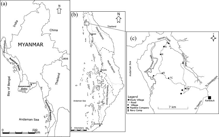
Fig. 1a Main Mangrove-Dominated Regions of Myanmar
Fig. 1b Location of the Study Area in Yaephyu Township, Dawei District, Taninthayi Region
Fig. 1c Map Showing the Location of Village K in the TC Village Tract
Since the British colonial period, the Ayeyarwady Delta has been developed into the world’s largest source of exported rice following reclamation of the old delta and the associated mangrove swamp of the upper part of the delta and conversion into paddy fields (Matsuda 2009, 19). The reclamation was carried out by the construction of artificial levees and relocation of a large number of farmers from Upper Myanmar for rice cultivation. However, the tidal mangrove swamp of the lower delta was conserved as forest reserves (253,215 ha) (Myanmar, Forest Department 2018). Under the socialist government, the area on the fringe of the mangrove reserves of the lower delta was reclaimed as paddy fields. One example was the Lower Burma Paddy Land Development Project, locally known as the World Bank’s embankment project, in the Ayeyarwady Delta. The project was implemented in 1976 with US$54 million in aid to protect existing paddy fields on 11 islands from flooding and saltwater intrusion and to reclaim abandoned paddy fields. The project constructed 659.8 km of earthen embankment to develop 15,378 ha of paddy fields in the middle delta area, about 136.8 km from the sea, and 59,489 ha of paddy fields on 10 islands in the lower delta area, about 80.5 km from the sea (World Bank 1976).
After the government initiated the paddy-field development projects, paddy fields encroached into mangrove reserved forest in the Ayeyarwady Delta from the 1970s. This was due to external forces such as the need for rice for the national subsistence policy, insurgency, redistribution, and weak enforcement of forest laws (Maung Maung Than et al. 2006; Toe Toe Aung et al. 2011; Ya Min Thant et al. 2012). Between 1978 and 2011, 81 percent of the dense-mangrove area was lost to paddy fields, which became the dominant proximal driver of mangrove deforestation in the Ayeyarwady Delta (Webb et al. 2014). As the local government strongly supported rice cultivation, paddy fields could be expanded in the reserved forests in the delta from 1998 to 2008 by paying a penalty of about US$0.25 ha/year to the Forest Department. Between 2013 and 2017, 49,114 households in 582 villages and about 125,819 ha of encroached land (including 114,219 ha of paddy fields) were excluded from the reserved forest area of the Ayeyarwady Delta under the de-reservation program of the Forest Department of Myanmar (Myanmar, Planning and Statistics Division, Forest Department 2018). Around the 1990s, an increase in the number of abandoned paddy fields was reported (Maung Maung Than et al. 2006; Toe Toe Aung et al. 2011; Ya Min Thant et al. 2012) and concerns arose about continuous rice cultivation and sustaining livelihoods in the area. As the agricultural policy was supported by the state without paying attention to the coexistence of mangroves and agriculture, indiscriminate conversion of mangrove forest into paddy fields was observed in the delta (Estoque et al. 2018).
In the coastal areas of Rakhine State, kari farming is a major driver of mangrove deforestation (Aye Aye Saw and Kanzaki 2015). Kari farming is a local practice of collectively building a dike bordering the areas intended for rice cultivation or shrimp farming after the mangroves have been cut for land reclamation. A kari farm is usually about 40–80 ha and is developed through the collaboration of 10–15 farmers, with an individual delineation of farming areas inside the dike. Based on crop productivity, the kari farm is cultivated with two alternative cropping systems, such as rice cultivation for some years and then shrimp farming after the loss of paddy productivity. During the 2000s (military-government period), extension of kari farms into the state’s mangroves was promoted by support from the local authorities through a localized program of granting land-use rights for a growing season of paddy or shrimp farming, which is locally called Pazun Ta Thar, Saba Ta Thi (key informant, U Maung Maung Kyi 2018).
As Rakhine State is located at the political periphery of the country, most of the mangrove areas are still in the communal land category,4) and some areas of mangrove are titled under two reserved forests (the Wunbaik reserved forest [22,905 ha] and the Minkyaung reserved forest [4,451 ha]) (Myanmar, Forest Department 2018). Daniel Richards and Daniel Friess (2016) reported that the percentage of mangrove deforestation by paddy-field expansion in Rakhine State increased between 2000 and 2009 before declining rapidly in 2010. The agricultural expansion occurred in both mangrove reserved forest and in mangrove areas on communal land; by 2014, 75,500 ha of mangrove forest had been lost to deforestation, mainly for rice cultivation (Estoque et al. 2018, 5396). An increase in kari farm expansion into the Wunbaik mangrove reserved forest from 2.7 percent of the reserved area in 1990 to 25 percent of the area in 2011 was also reported (Aye Aye Saw and Kanzaki 2015). Based on a 2013 record of the Forest Department for the de-reservation program, 2,919 ha of paddy fields cultivated by 736 households encroached into the two mangrove reserved forests of the state. Although data about kari farm abandonment have not been accessed, farmers experienced yield diminishment over time due to soil acidification and saltwater intrusion (Aye Aye Saw and Kanzaki 2015). The current social unrest (e.g., religious conflicts and ethnic army and government conflicts) in the state may result in more poverty and dependency on unsustainable agricultural practices.
In comparison with other regions of the country, rice production in Taninthayi Region was low during the insurgency period, mainly on account of subsistence use because of the high cost of exporting rice due to poor infrastructure. However, as a result of the promotion of regional subsistence rice projects in the socialist- and military-government periods, there was significant agricultural expansion in Taninthayi Region, with an increase in paddy fields in Dawei and Myeik Districts (Songer et al. 2009). By 2017 the region had 442,639 ha of net agricultural cultivated area: 76.2 percent orchards, 21.5 percent paddy fields, and 2.3 percent other cropland; 14.8 percent of the paddy fields in the region had been abandoned (Myanmar, General Administration Department 2017). Mangroves in Taninthayi Region now represent the largest mangrove area in Myanmar. They are generally in good condition; however, some researchers such as Grant Connette et al. (2016) considered 66 percent of the mangrove forests in the region to be degraded, with the remaining mangrove areas within protected areas and forest reserves. Because the region is on the political periphery of the country, most of the mangrove areas are still in the communal land category, especially in Dawei and Kawthaung Districts, and some areas of mangroves are titled as reserved forests, mainly in Myeik District. By 2013, the records of the Forest Department under the de-reservation program showed encroachment into mangrove reserved forests by 4,629 households in 54 villages and about 9,408 ha of land, including 3,339 ha of paddy fields and 3,103 ha of orchards. Furthermore, due to the country’s economic reforms focused on the development of industrialization and agriculture, the shallow sloping coastal zone of Taninthayi Region became an ideal location for arable land, leading to a frontier of mangrove degradation in the region (Gaw et al. 2018).
Because the country still has a large area of cultivable waste land (communal land), which accounts for 5.7 million hectares—half of the net sown area—and because reclamation will be accelerated in the near future under the Vacant, Fallow, and Virgin Lands Management Law enacted in March 2012 (Fujita 2016), the potential for agricultural expansion into mangrove areas still exists, especially in the coastal agroecological regions, even though mangrove paddy-field development has been reported to be an unsustainable agricultural practice based on evidence of its abandonment5) after one to two decades of rice cultivation due to loss of productivity, saltwater intrusion, and weed invasion (Maung Maung Than et al. 2006; Toe Toe Aung et al. 2011; Ya Min Thant et al. 2012) in the Ayeyarwady Delta and Rakhine State (Aye Aye Saw and Kanzaki 2015). Some quantitative studies on mangrove cover changes (Giri et al. 2008; Webb et al. 2014; Connette et al. 2016; Estoque et al. 2018) and mangrove plantation and recovery of abandoned paddy fields (Maung Maung Than et al. 2006; Toe Toe Aung et al. 2011; Ya Min Thant et al. 2012) have been conducted with a special focus on the mangroves of the Ayeyarwady Delta. However, studies on paddy-field development in mangroves, abandonment of fields, and the consequences for agroecology and the socioeconomic conditions of local inhabitants have not considered regional development planning and sustainable management for resource use. It is also unclear how ecological and sociopolitical factors combine to influence paddy-field establishment and abandonment in mangroves and the consequences thereof for agroecology and socioeconomics at the community level.
Based on the area’s ecological importance as the last frontier of mangroves in Myanmar and its having the highest potential for degradation due to agricultural expansion and economic development projects, we selected a village in Taninthayi Region to study, to clarify the conditions and practices of paddy-field establishment in mangroves and also to address the complexity of paddy-field abandonment processes and the responses of farmers. The consequences for local livelihoods and the socioeconomic situation of local farming communities after paddy-field abandonment were also examined. Through an agroecological timeline and a coupled human–environment timeline, the combined influences of ecological and sociopolitical factors on the system were evaluated to provide a resource for regional planning and management of continuous paddy farming and sustainable local livelihoods in the future.
II Methods of Study
II-1 The Local Setting
Taninthayi Region, in the southernmost part of Myanmar, comprises more than 800 islands and covers an area of 43,345 km2 in three districts (Dawei, Myeik, and Kawthaung) (Fig. 1b). It has a population of 1.4 million people, 30 percent urban and 70 percent rural. It is one of the least densely populated regions (32.5 people/km2) of the country (Myanmar, Department of Population 2015). The land use of the region is 56.8 percent forested area, 8.2 percent agricultural land, and 35 percent other land uses. In the total forested area (24,638 km2), approximately 50 percent is titled under forest management and the remainder is in the untitled land category of state control (Myanmar, Forest Department 2015). The region has a tropical monsoon climate with abundant rainfall (5,594 mm/year) and an average temperature of 26°C. It has abundant natural resources and an economy driven by agriculture, forestry, mining, and fisheries, with an increasing amount of tourism. The security of the region has improved because of the ceasefire agreement with non-state armed groups such as the Karen National Union in 2012 and the New Mon State Party in 2018. The huge area of land in the communal land category and the improved security indicate that the region has much potential for economic development projects, especially in coastal regions, which are currently becoming a new deforestation frontier in Southeast Asia (Gaw et al. 2018).
By the year 2017, 95,266 ha of paddy fields6) had been developed in the region: 42 percent in Dawei District, 53 percent in Myeik District, and 5 percent in Kawthaung District. Of these paddy fields, 12,366 ha—71.6 percent in Dawei District, 17 percent in Myeik District, and 11.4 percent in Kawthaung District—had been abandoned. Dawei District, which is the most accessible part of the region, includes four townships and two sub-townships with an area of 14,004 km2; this includes 44 percent forested area, 12.1 percent agricultural land, and 43.9 percent other land (Myanmar, Forest Department 2015). The district has a total net cultivation area of 152,864 ha, including 71 percent orchard land, 26 percent paddy fields, 2 percent nipa farms, and 1 percent ya (upland farming). Of the total area of paddy fields in the district (40,002 ha), 25 percent (10,094 ha) has been abandoned. Since the socialist-government period, coastal mangroves have been cut and converted into paddy fields through government development projects and local subsistence activities in the district.
Yaephyu Township is an agriculturally developed township in Dawei District that has 45,473 ha of agricultural land: 80.7 percent orchard land, 18.7 percent paddy fields, 0.3 percent ya cultivation, and 0.3 percent nipa farms. As of 2017, 8,502 ha of paddy fields were producing and 29 large-scale polder fields (18 government and 11 private fields) had been developed (Myanmar, General Administration Department 2017). Consequently, 39.7 km of soil embankment had been constructed to benefit 1,577 ha of rice cultivation in the coastal areas of the township. In general, the paddy fields were established by cutting mangrove forest and building embankments to control saline water, tides, and inundation. Since 1998, embankment breaching has become the major hindrance for rice cultivation in the coastal areas. The demands for assistance to rehabilitate sluice gates and embankments have been increasing each year, and this has become a concern for regional developers, policy makers, and nongovernmental organizations (Yadanar Corporation 2017). In 2017, 45.3 percent of the total area of paddy fields in the townships (approximately 3,849 ha) had been abandoned.
This study was conducted in village K of the TC village tract (anonymous designations), a mangrove rice cultivation area in Yaephyu Township. The village tract includes nine villages comprising 1,299 households and 6,855 inhabitants. Rice cultivation and orchard farming are the most common livelihoods; 1,741 ha of paddy fields and 949 ha of orchards are under cultivation. Four villages inhabited by the Mon ethnic group—namely, villages K, M, B, and G—cultivate rainfed lowland paddy fields established in mangrove areas of the village tract.
Village K is connected by a 12 m-wide earth road to village N to the north and village B to the south (Fig. 1c). There are 19 households in the village, and the total population in 2017 was 126 inhabitants. Village K was developed in a fringe region between small mountains and the coastal floodplain. The village is neighbored by two small mountains with elevations of 60 m and 147 m above sea level, respectively, in the southern and southeastern parts of the village. There are large areas of tidal flat plain, once dominated by mangrove, in the northern, western, and southwestern parts of the village. Village K was established in connection with the development of a mangrove paddy field (named field A) by three landless families in the 1960s. Then, a 283 ha large-scale paddy field was established under the government paddy development program in 1965 (named field B). As a consequence of this project, local-scale encroachment by another paddy field (named field C) into the mangrove cover of the existing embankment followed. Thus, between 1959 and 1987 three paddy fields were developed in the tidal flat plains of village K. These paddy fields were abandoned 10–20 years ago.
II-2 Field Surveys and Socioeconomic Assessment
This study was conducted through surveys of mangrove paddy fields and socioeconomic assessments during two field visits in November and December 2017 and December 2018. Before the study area was selected, reconnaissance surveys in the TC village tract and in village tracts in its vicinity were conducted through interviews with village leaders and experienced farmers, and observations were made in the mangrove paddy fields of each village. Additionally, the agricultural experts of the Yadanar Corporate Social Responsibility (CSR) program were interviewed to clarify the conditions of agriculture development and the transition of the study area based on their 30 years of experience in assisting agricultural sectors as part of a CSR program for a natural gas transportation project in the area. After the reconnaissance survey, we selected the TC village tract and performed an in-depth study of village K. During the field survey in 2017, the structure of mangrove paddy fields and the conditions of currently cultivated paddy fields, fallow paddy fields under embankment repair, and abandoned fields were assessed in village K and the TC village tract. Background information, such as maps and official data concerning paddy-field development in the TC village tract, was collected from the Department of Agriculture Land Management and Statistics (formerly known as the Land Records and Survey Department), and officials from the department were interviewed. In addition, maps of paddy-field development in mangrove areas of village K and the TC village tract and the reconstructed structure of embankment breaches in the government-imposed paddy field of village K were developed. These were based on time-series data from the Google Earth basemap (satellite images, 1984–94, 2003, 2010, 2011, 2012, 2014, and 2016) combined with information from a one-inch map (95 F/14) survey, H. Q. Twelfth Army 3rd edition (1945), and a kwin map, field no. (497–498), by survey team (2) Yangon (1967–68) of the Department of Agriculture Land Management and Statistics. A ground truth check of these maps was conducted during the second field survey at the TC village tract in 2018.
Through the questionnaire survey, six aspects of household information were assessed: basic household information and livelihoods, paddy-field conditions, orchard development, out-migration, fisheries, and potential mangrove rehabilitation. Among the 19 households of village K, the questionnaire survey was conducted in 18 (95 percent of total households). The remaining household, consisting of a single man who had been left by all his family members for social reasons, was not willing to participate in the survey. The survey participants included 13 male and 5 female heads of household ranging in age from 18 to 67 years. Among the 18 households interviewed, 14 were Mon ethnic group households and 4 were Burma ethnic group (2 Dawei and 2 Burma) households. Twelve of the households interviewed owned paddy fields that had been abandoned. A participatory village profile assessment was also conducted to develop a human–environment timeline and assess the agroecological changes. Establishing a complete overview of the village from the time of paddy-field development to the present involved the participation of second-generation members of the three pioneer families who had developed field A, village heads, experienced farmers, orchard owners, former migrant workers, and casual laborers. The results are presented through narrative analysis methods with reference maps.
III Results
III-1 Local Paddy-Field Development Practices
People from the Mon ethnic group followed three fundamental steps when converting mangrove areas to paddy field. First, they built soil embankments (taman) around the area intended for paddy-field development to protect the field from inundation and saltwater intrusion (Fig. 2a). Depending on ground levels and tide conditions, the embankments usually had a 3–6 m footing at the base with an embankment 1.2–2.4 m in height and a top width of 1.8–2.4 m, built by compacting soil layers (Fig. 2b). Thicker and higher embankments than the common structure were constructed to block creeks. The embankments were usually built manually through the collective work of farmers on neap-tide days (6–12 waxing and waning days of the lunar calendar) between October and mid-May. Depending on the area intended for use and the availability of resources, embankment construction took about three to five years to complete.
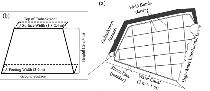
Fig. 2a Structure of a Mangrove Paddy Field
Fig. 2b Cross-sectional Structure of an Embankment (Taman) in Village K
Note: The illustration of the common structure was developed based on field observations in six paddy fields in the TC village tract and key informant interviews with experienced local farmers from village K.
The second step of paddy-field development was land reclamation, including mangrove cutting and land preparation for rice cultivation. This step began with allocating an area inside the embankment to each farmer who had participated in embankment building. The mangroves inside the embankment were killed by waterlogging (i.e., maintaining the water level above the height of the aerial roots of the mangrove) from May to September, the entire rainy season in the year following embankment building. Based on workforce and resource availability, the farmers subdivided their individual areas into annual-basis mangrove cutting plots. The mangroves in these plots were cut on neap-tide days between October and March/April. The cut trunks, branches, and leaves were dried in the field through the summer and set on fire before the monsoon. In the rice cultivation season (June to July), early-maturing rice, kaukyin, such as Eicalae and Eaemahta, was broadcast onto the cleared area, where there was still partially burned mangrove debris. The major aim of sowing the rice was to have subsistence rice for the next year of mangrove cutting and to use the rice straw as tinder to burn the residual mangrove parts and debris as part of preparing the plot. In the second year of land preparation, the mangrove stumps were dug out during the dry season and the mangrove debris and rice straw were burned again in December. Cattle were used to trample the burned debris and soil, thereby mixing them, early in the rainy season, which is usually after mid-May, as land preparation for the second year of rice cultivation. Then, early-maturing rice was sown again in the rice cultivation season. In this way, the paddy field was prepared year after year until it attained a plowable condition.
The final step in permanent paddy-field development was the building of field bunds (kazin). Based on ground levels, the bunds were built to grow various varieties of rice, control water levels during the growing season, and delineate each individual border of ownership inside the embankment. After a permanent paddy field was established, the farmers commonly grew a medium-maturing rice, kauklatt, such as kaukgyi or mitone. In the study area, late-maturing rice, kaukgyi, was grown only on very low land or in flooded plains. Early-maturing rice was grown only during the land-preparation processes, when the farmers grew the rice using the Malayan practice of cattle trampling and broadcasting (Takaya 1987). After permanent paddy-field development, the rice cultivation practice of plowing the field with cattle and broadcasting rice was implemented in the study area. The agricultural calendar began with taman, kazin, and sluice gate repair from February to May, followed by field plowing from May to the end of June. Rice was sown in July. Depending on the growing period of the rice variety (e.g., kaukyin, 140–150 days; kauklatt, 150–170 days; or kaukgyi, 170–200 days), weeding and grass cutting were carried out until harvesting (October–December). After the harvest season, the paddy fields were left fallow through the summer.
III-2 Conditions for Paddy-Field Development in Mangroves
Paddy-field development in a mangrove area of village K was started as subsistence cultivation by three landless families from village M in 1959. When field A was developed in the mangroves (locally considered common land), there was no settlement at the site, which was difficult to access from village M. Based on the high-water line at the foot of a hill, above which the tide seldom rises, an embankment facing the major waterway was constructed by connecting to a natural levee consisting of a sand ridge inside the mangrove area. Field A was not developed like a polder field, for which at least three sides of a field are bordered with embankments. In this case, the local geographic setting (i.e., the natural levee and high-water line) was taken into consideration for field development, and only a short length of embankment was constructed. Field A, with an area of 8.4 ha, covered only the end of a small creek, with minimal mitigation of the water action of tides and inundation (Fig. 3a). The development processes took about 14 years (1959–72): embankment building five years, mangrove cutting and land preparation two years, and permanent field development seven years. During the time of embankment building, the three families relied on swidden cultivation in the hill areas around field A.
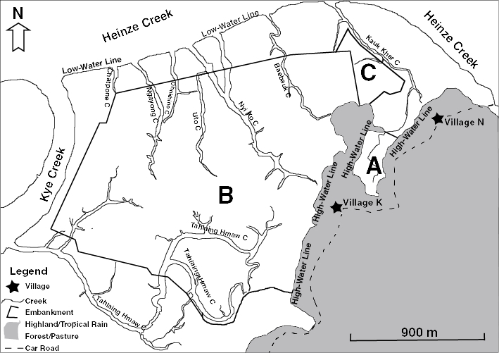
Fig. 3a Map of the Three Paddy Fields Developed in Village K (1959–87)
Note: The map was developed by adding the information from the one-inch map (95 F/14), survey H. Q. Twelfth Army 3rd edition (1945), the kwin map, field no. (497–498), by survey team (2) Yangon (1967–68) of the Land Record and Settlement Department, Myanmar, and the field surveys of 2017, to the geo-reference Google Earth basemap.
Based on information indicating high yields from field A, and the national rice subsistence policy of the government, the government-supported paddy-field development project was started in the mangroves of village K in 1965. In the development of field B, 283 ha of mangroves were bordered with embankment and reclaimed for paddy fields. Field B was established as a polder field by constructing embankments from the high-water line on the east side to the mangroves in three directions (north, west, and south) to border the entire area of the paddy field. The waterways of seven creeks and their floodplains were blocked by the embankment during field B development (Fig. 3a). The embankment was constructed with manual labor from 1965 to 1970. The government provided financial support of US$0.17–0.217) for each 0.03 m3 of embankment constructed and US$0.50–0.67 for each 0.03 m3 of creek-blocking embankment. After embankment construction, the government allocated 283 ha of paddy to one hundred landless households from three villages in the TC village tract. The Land Records and Settlement Department of Yangon surveyed the individual areas (2.83 ha) allocated to each farmer and registered the land in the category of paddy field (le) between 1967 and 1968. Land reclamation was carried out by the allocated farmers until the permanent paddy-field development stage without government support. The development of field B took about 16 years (1965–80): six years of embankment building, five years of mangrove cutting and land preparation, and five years of permanent paddy-field development.
After the government paddy-field-development project in the study area, extension of paddy fields into the mangrove cover by local people accelerated. Based on the existing embankment of field B, five farmers extended 16.2 ha of paddy field (field C) into the mangrove cover by constructing embankments to develop a polder field. The embankment of the field was built near the low-water line to which the tide rises every day, with very little mangrove cover outside the embankment (Fig. 3a). Within five years, from 1983 to 1987, the farmers developed field C into permanent paddy fields.
During the 1990s, individually based small-scale paddy fields were also extended from the existing embankment of field B into mangrove cover in village K (Fig. 3b). This practice reduced the strength of the existing embankment as a result of reducing the floodplain area outside the embankment at high tide, thereby increasing the intensity of water action and accelerating erosion of the embankment. The individually extended fields had a very short cultivation lifespan of no more than five years. The interview with the key informant and the analysis of satellite images of the land use of different time series showed that about four paddy fields, ranging in area from approximately 12 to 121 ha, were also developed collectively into the mangroves of the TC village tract in the 1990s (Fig. 3c), after the government paddy-field-development project. The extension of paddy fields into the mangrove cover of the communal land of the village tract was supported by the local authority under the agricultural development policy of sown acreage expansion.
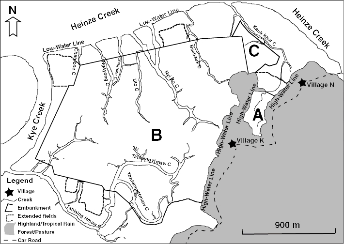
Fig. 3b Map of Individually Executed Local-Scale Extension of Paddy Fields from the Embankment of Field B
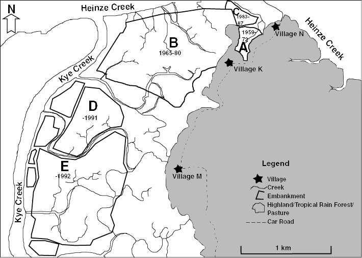
Fig. 3c Extension of Paddy Fields in the TC Village Tract (1959–92)
The analysis of the map developed by the British military (1945), key informant interviews, and field observations indicated that the extended paddy field areas were once covered with extensive mangrove forests dominated by Sonneratia species (Laba), Avicennia species (Thamae), Xylocarpus species (Kyana, Pinle Ohn), Rhizophora species (Bue Chaetaut), Bruguiera species (Bu), and Nypa fruticans (Da Ni). The interviews revealed that mangrove trees with a girth of 2–3 m were removed for the paddy-field-development processes in the area of village K. After the 1990s, encroachment of paddy fields into mangrove cover was promoted more extensively; even mudflats dominated by Nypa fruticans were developed into paddy fields. Nypa fruticans is the most highly adapted species, other than mangrove, to resist fast-running water and has the highest survival at the lowest water levels (Giesen et al. 2006). Thus, the natural floodplains of the existing creeks in the TC village tract were severely damaged, and the waterways were blocked by embankments (Fig. 3c). With the extreme emphasis on paddy-field development in the area, no attention was given to sustainable coexistence of mangroves and agriculture, and extensive areas of mangrove were cleared.
III-3 Causes of Paddy-Field Abandonment and Responses of Farmers to Embankment Breaches
Among the paddy fields in village K, the embankment of field C, located nearest the low-water line, was the first to be breached. In 1992, five years after field C was permanently developed, large-scale breaching8) of the embankment occurred at the sluice gate during the March spring tides. In coastal areas of Myanmar, the highest tide levels every year are on the spring-tide days of Tabaung (March) and Tawthalin (September). Local farmers know that these spring-tide days bring a high possibility of embankment breaching. In the case of field C, the farmer reconstructed the aforementioned breached embankment before the rice-growing season, and paddy was grown that year. However, the paddy could not be harvested because of frequent embankment breaching during the growing season. Further repair of the embankment was beyond the ability of the five farming families, which led to the abandonment of field C in 1992.
The first large-scale embankment breach in field B occurred before paddy harvesting in September 1996. The creek-blocking embankments were breached, mainly in three places between the water gates and the creeks. The hundred farmers who shared field B collectively reconstructed the embankment by contributing manpower and financial resources equally. However, the yield of field B was significantly diminished; this caused the farmers to lose their profits for the year due to both the decreased yield and the costs of the embankment repair. After two growing seasons, the embankment was breached again in two locations in September 1998. The embankment could not be rebuilt quickly after the breach, and rice production was lost for the year. A new embankment structure was then built by dividing the field into two parts along the main creek, where most of the embankment breaching had occurred (see structure of second repair in Fig. 4). With a loan of US$40,000 and machinery from the General Administration Department of Yaephyu Township, as well as an additional financial provision of US$300 per individual farmer, the embankment was reconstructed in 1999. After the construction work, field B was resurveyed and 2.63 ha of field were allocated to each farmer. Although paddy was grown that season, the yield was significantly diminished. Faced with diminishing yield9) and repaying the loan for embankment reconstruction (US$400/farmer) to the General Administration Department, some farmers began to sell their paddy fields. Others grew paddy for the next two growing seasons, but yields were diminished. In 2002 the field B embankment was breached again, and the farmers stopped growing rice. However, large-scale rebuilding and maintenance of the embankment were carried out in 2003 with government funding and machinery assistance. Because the government could not afford to rebuild the entire area of field B, only part of the embankment was rebuilt (see the structure of the third repair in Fig. 4). Construction work was completed by the start of the rainy season, but a new reallocation of land could not be made, so the farmers could not grow paddy because of the limited time for clearing weeds and regrowth of mangroves in the field. Late in the rainy season of 2003, the embankment was breached again. Within two decades of the start of cultivation after the permanent paddy-field development processes, field B was abandoned.
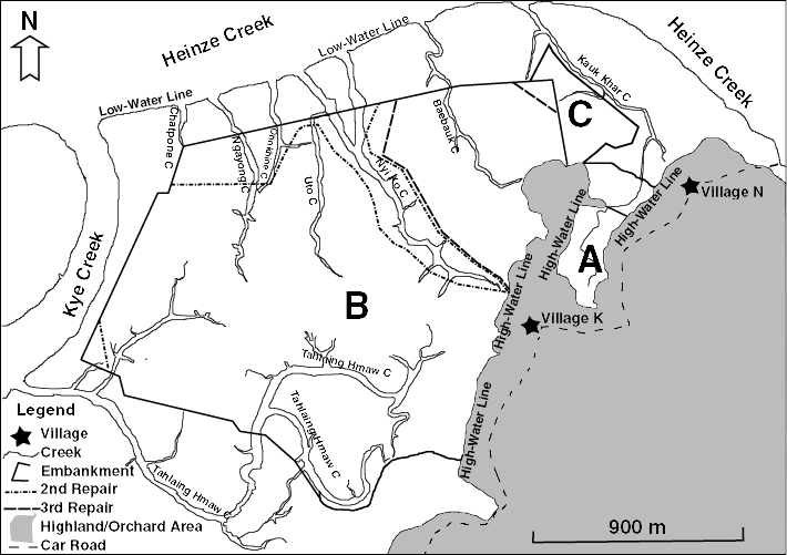
Fig. 4 Map Showing the Frequent Repair and Reconstruction of the Embankment of Field B by the Government (1959–2017)
In March 2011, the embankment of field A was breached. However, three farming families sharing manpower and resources equally rebuilt it immediately. Paddy was sown in time for the growing season, but the embankment was breached again in September, before the paddy was harvested. The farmers could not afford to rebuild the embankment, having had no paddy production for the year, so field A was abandoned. However, at 38 years, field A had the longest cultivation span after the implementation of the permanent paddy-field development processes.
Frequent embankment breaches and limited financial resources for embankment repairs were the two major causes of mangrove paddy-field abandonment. Based on observations at the site, the field developed closest to the riverbank or water channel (low-water line) with relatively little mangrove cover had the soonest potential of embankment breaching and the shortest lifespan. Within two to three decades of rice cultivation, the mangrove paddy fields in the study area were likely to be abandoned because of frequent embankment breaching. The practice of paddy-field extension from existing embankments into protective mangrove cover was inappropriate because it weakened the embankments and accelerated breaching. However, local-scale paddy-field development with an understanding of specific site conditions and water levels, as in field A, might be a possibility for continuous rice cultivation in mangrove areas.
III-4 Demographic and Livelihood Changes
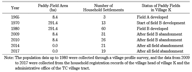
In 1965, there was no permanent settlement in village K. During the paddy-growing season, three farming families settled around field A in temporary tents, but they still maintained their homes in their native village (M), which was connected to the field by a footpath. When the embankment of field B was completed in 1970, about 10–15 households, including the three pioneer farmer families, relocated from nearby villages to village K and settled permanently to develop the paddy fields they had been allocated by the government. Migration from other villages to village K increased in 1975 with the development of the government paddy field. Approximately 50 households, including the field owner and laborer families, moved to village K. A cart road from village K to village M was also developed. In the 1980s, the settlement in village K increased to 60 households due to the development of the rice cultivation business. A self-financed primary school and village monastery were established in 1980. The village primary school was declared a government-supported primary school in 1986. The number of households in the village was stable through the paddy-cultivation period, but it changed distinctly after paddy-field abandonment. The number of settled households in the village decreased steadily, to 31 in 2009, 26 in 2010, 21 in 2014, and 19 in 2017 (Table 1).
Table 1 Changes in the Number of Households with Paddy-Field Development and Abandonment in Village K
In 2017, 31 percent of the population of village K was economically inactive (i.e., 25 percent under 15 years of age and 6 percent over 60 years of age); thus, 69 percent of the population was between 15 and 60 years of age. The average annual household income of the village was US$2,531, from nine sources of income: out-migration (US$852), casual labor (US$617), orchard farming (US$285), crabbing (US$234), shopkeeping (US$225), home gardens (US$79), nipa production (US$78), livestock breeding (chickens and pigs) (US$56), and others (e.g., transportation) (US$88). The highest percentage of income was contributed by remittances from out-migrants working in Thailand.
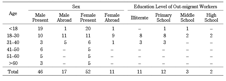
Out-migration from the TC village tract to Thailand started in 1998, but it became common in village K around 2004, after the abandonment of field B. In the 18 households studied, 44 percent of the interviewees had experience as migrant workers in Thailand as a consequence of paddy-field abandonment. This study showed that 22 percent of laborers from the total population (126 people) of the households in the study worked in Thailand, and this work supported the subsistence of 67 percent of the total households in village K (Table 2). The out-migrant workers included 7 percent under 18 years old, 71 percent 18–30 years old, and 22 percent 31–40 years old. Based on the questionnaire survey, 39 percent of the out-migrant workers were illiterate and 43 percent had less than a primary-school education. The out-migrant workers worked mainly as wage laborers in Thailand, in the so-called 3D jobs—dirty, dangerous, and demeaning—typically in sectors such as agriculture, fisheries, processing of fishery products, forestry, construction, and domestic work (Fujita et al. 2010), which require physical strength and stamina. After the age of about 40 years, almost all of the migrant workers returned from Thailand because of the limited age preference of employers for wage laborers and the greater difficulty of finding a job after the age of 40. Because remittances by out-migrant workers contributed greatly to village income and subsistence, the sustainability of these workers’ livelihoods was important for the village.
Table 2 Ages and Educational Status of Out-migrant Workers in Village K
III-5 Orchard Establishment to Safeguard Livelihoods
At the time of field A’s development, swidden farming (taungya) with a mixed-crop cultivation system (i.e., cultivation of taungya by mixing annual crops such as upland paddy, sesame, groundnut, etc., and perennial trees such as cashew nut, jackfruit, betel nut, etc.) was practiced in the TC village tract. This cultivated land was locally recognized as being the orchard of the taungya cultivator, and the products of the perennial trees were harvested after the swidden lifespan. Commercialized orchard development in the TC village tract, producing a boom crop for the region, started in the 2000s under regional development projects such as the Oil-Pot Project (oil palm plantations) and White Gold Project (rubber plantations). However, in village K orchard development began in the 2010s, after the paddy fields had been abandoned for 10–20 years. The villagers developed their orchards as a strategy for an alternative means of livelihood because of the limitations of sustaining their livelihoods through out-migration and because of market demand for orchard crops. By saving remittances from out-migrant workers and investing these funds in orchard establishment, the villagers converted former swidden fallows, traditional orchards, pasture lands, and degraded forests around the higher ground in the village into commercial rubber plantations and betel nut and cashew nut orchards (Table 3).
Table 3 Orchard Cropping Patterns and Areas of Orchard Development in Village K
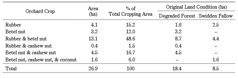
In total, 26.9 ha of land around village K were transformed into commercial orchards between 2002 and 2017. In 2010 the swidden fallows, traditionally recognized as the orchards of the ancestors, were shared without cost among family members, relatives, and friends with the agreement of generations of the three families that developed field A, who had inherited the land-use rights for those fallow lands. However, in 2012–13, these fallow lands were sold among the villagers for the establishment of orchards. In village K, after the paddy fields had been abandoned for 10–20 years, 87 percent of the former paddy-field owners had established orchards, ranging in size from 0.8 ha to 5.7 ha. There was no production from the young plantations of rubber and betel nut until 2017. Even though legal approval for orchard land had not been granted by the government, the villagers had already established orchards and there was no more land available for the extension of orchards. The orchard lands were part of land acquisition by the military (the navy camp in the area), so legal recognition of the orchards by the government was uncertain due to conflicts over land-use rights between the military and the local people.
IV Discussion
IV-1 Sociopolitical Support for Paddy-Field Development
External sociopolitical conditions, such as national politics, agricultural policy, insurgency, and land management, supported the expansion of paddy fields into mangrove areas. This expansion can be understood through the associated human–environment timeline (see the section on external drivers in Fig. 5). As Taninthayi Region experienced the longest period of civil conflict, village K was under conditions of insurgency from 1950 to 2004, including the countrywide civil conflict (1950–70), Pyi Chit Group (local insurgents) (1970–80), and New Mon State Party (1980–2004) periods. According to the Land Nationalization Act (1953), all land was state property; however, this law was weakly enforced under the insurgent conditions. Because mangroves were locally considered communal land, the three landless families in village M expanded the paddy field (field A) into mangrove forests in the study area for household subsistence. The paddy-field expansion into mangrove forests in village K and the TC village tract became better defined during the socialist-government period (1962–88) and at the beginning of the military-government period (1989–2010). The state’s economic policy during both periods was “development of agriculture as the base and overall development of other sectors of the country as well” (Kyaw Myint 1999). During the socialist period, the agricultural policy was one of agricultural exploitation, with a heavy emphasis on rice production under the state procurement and rationing system (Myat Thein and Maung Maung Soe 1998; Fujita et al. 2009; Fujita 2016). Throughout the socialist-government period and at the beginning of the military-government period (up to the late 1990s), the country’s first priority had been to increase rice production through expansion of agricultural land (Myat Thein and Maung Maung Soe 1998; Fujita et al. 2009; Matsuda 2009). As the agriculture sector was given priority in the national economy, with a growing population, the socialist government developed the 20-year Long-Term Plan (1974–75 to 1994–95) with the goal of expanding the country’s rice-growing area by 5.87 million hectares, with total rice production of 1.86 million metric tons (Kyaw Myint 1999). Therefore, state-imposed paddy fields, such as field B in village K, were expanded into mangrove areas. As field B in village K was expanded by the government into tidal mangrove swamps, considered locally to be communal land, local-scale paddy-field expansion, such as field C and other individually expanded fields based on the embankment of field B, accelerated into the far more marginal mangrove areas nearest the low-water line, leaving no mangrove cover. The “rice trauma” of politicians due to the frequent national crises concerning rice shortages supported the expansion of agricultural land until the military-government period (Fujita et al. 2009). Furthermore, the immediate changes in agricultural policy in 1987–89 allowing privatization of the foreign and domestic rice trade, relaxation of the government’s monopoly in domestic rice marketing, and a reduction in the quota per paddy basket per 0.4 ha in the military period (Myat Thein and Maung Maung Soe 1998) also encouraged local people in the study area to extend paddy fields into mangroves. The mangrove areas were considered communal land, with the support of the local authority under the political forces, as part of target acreage allocations set by the government under agricultural extension programs (Matsuda 2009). In the 1990s, the extension of paddy fields into mangroves was very distinct in the TC village tract, with less focus on sustainable rice cultivation and environmental perspectives.
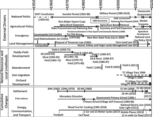
Fig. 5 Human–Environment Timeline of Village K (1950–2017)
Note: EB: embankment building; Mcut: mangrove cutting and land preparation; Field: permanent paddy-field development; HH: households.
IV-2 Changes in Agroecological Settings Resulting from Paddy-Field Development and Abandonment
The natural mangroves in the study area were changed in 1959 by the development of local-scale paddy fields for subsistence rice production during the period of insurgency. At the time of paddy-field expansion, the specific local geographic setting and ecological conditions were taken into consideration for field development. Based on the existing natural levee, the shortest length of embankment was constructed to block one creek, and only the end part of a natural waterway was destroyed by the development of 8.4 ha of fields. When state-imposed paddy-field development was implemented in the mangroves, extensive areas of tidal mangrove swamps were cut and the natural waterways of seven creeks were blocked by constructing hugely expensive embankments. No attention was given to mangrove–agriculture coexistence during the development of field B in village K, and 283 ha of mangroves with an average girth of 2–3 m were removed and considerable species diversity was lost. In the 1980s, the deforestation of mangroves in village K became clear. Following the state-imposed paddy-field development into mangrove forests, the much more marginal land nearest the low-water line was damaged through local-scale paddy-field development in village K and the TC village tract in the 1990s. Based on the agroecological timeline (Fig. 6), more than 300 ha of natural mangroves around village K were completely converted to paddy fields in the 30 years between 1959 and 1990.
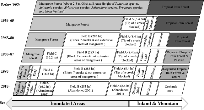
Fig. 6 Changes in Agroecology of Village K (1950–2018)
Except for the development of field A, paddy-field expansion in the study area was not focused on the sustainable coexistence of mangroves and agriculture; therefore, areas of mangrove were destroyed indiscriminately, similar to the conditions of paddy-field development in the Ayeyarwady Delta (Estoque et al. 2018) and Rakhine State (Aye Aye Saw and Kanzaki 2015). The paddy field developed nearest to the low-water line, with the least mangrove cover, had the shortest lifespan of the paddy fields developed for cultivation. The first paddy fields to be abandoned were those that individuals developed based on the embankment of field B and the paddy field developed nearest the low-water line (field C); the cultivation lifespan of these fields was not more than five years. The state-imposed paddy fields were developed with little consideration for their local geographic setting, the actions of water, or the protection of mangroves, and they could not achieve continuous rice cultivation and production. Within two to three decades of rice cultivation, this type of mangrove paddy field had high potential for abandonment and frequent embankment breaches. Field A, developed by local practices based on the specific geographic setting, minimal destruction by water action, and maintenance of reasonable protective mangrove cover outside the field, had a longer cultivation lifespan and higher potential for continuous rice cultivation. Since the 1990s, the paddy fields in village K have gradually been abandoned; and the production of rice in the study area from more than 300 ha of paddy fields was completely lost within 21 years. As the strength of the embankments was directly correlated with the sustainability of the fields, all of the individual fields within an embankment were impacted when the embankment was breached. Mangrove paddy-field development had been based on the collective action of building the embankment, so abandonment of the embankment caused abrupt changes to the environment and the livelihoods of local people. After the extensive paddy-field abandonment in the area of village K, combined with external factors such as the introduction of boom crops in the region, the market demand for these crops, and the livelihood uncertainty of out-migration work, the old swidden fallows and degraded tropical rainforest around the village area were converted to orchards from 2010, and the cultivation of orchard trees intensified. By 2017, 26.9 ha of orchards had been developed around village K, but legal recognition as orchard land by the government was uncertain because the orchards were part of land that had been acquired by the military. Because the coexistence of mangroves and agriculture was not regulated during paddy-field development, alternative types of production could not easily be achieved when the fields were abandoned. Existing natural resources (degraded tropical rainforests and old swidden fallows) were consequently impacted again for orchard development.
IV-3 Consequences of Abandoned Paddy Fields on Demographic Conditions and Livelihoods
The major goal of paddy-field development is to increase national rice production and promote rural development. However, the development of paddy fields in mangrove areas needs to take into consideration the possibility of abandonment due to the high risk of embankment breaches and the high cost of embankment maintenance. Unlike paddy fields in other regions, paddy fields in the mangrove areas of village K were developed collectively inside an embankment. Thus, demographic conditions and local livelihoods were severely impacted by embankment breaches and subsequent abandonment. Demographic conditions in village K were fairly stable during the period of rice cultivation but changed greatly after field abandonment, with the number of households decreasing from 60 at the time of rice cultivation to 19 by six years after all paddy fields had been abandoned.
The livelihoods of the local population, which had been agriculture based—especially rice cultivation—also changed completely to non-farming livelihoods after paddy-field abandonment. Out-migration to Thailand from the TC village tract began in 1998; however, in village K it began in 2004, the year after paddy-field abandonment due to frequent embankment breaches. By 2017, the subsistence of 67 percent of village K households was supported majorly by remittances from out-migration, which contributed the highest portion of the average annual income of the village among nine income sources. Out-migrant workers from village K worked mainly as wage laborers in 3D jobs in Thailand. From this study, we discovered that most out-migrant workers over the age of 40 returned to the village because of difficulties in finding a job due to the restricted age preference of 3D employers, since the work required physical strength. Fujita Koichi et al. (2010) also reported a wide range of serious problems faced by migrant workers from Myanmar in everyday life in the Ranong area of Thailand,10) such as harsh working conditions, low income, heavy indebtedness, risk of falling victim to human trafficking, harassment by police and the military (especially of sex workers), high risk of illness (malaria and HIV/AIDS), limited access to affordable medical facilities, and a poor educational environment for their children. Therefore, the villagers in village K assumed that livelihood sustainability through out-migration was also uncertain and invested savings from out-migration in orchards as an alternative strategy to sustain their livelihoods. Orchard development impacted the conversion of degraded forests and old swidden fallows around the village, even on land where the legal right of use for orchard farming was uncertain due to land acquisition by the military. Even though orchard farming still faced uncertain sustainability and the market prices and conditions of boom crops in the region fluctuated, the upland forest resources were heavily converted to orchards.
As a result of national political changes, there were improvements in local education, transportation, and communication conditions (see the cumulative changes in Fig. 5). These improvements included middle-school access in the nearest village (a 30-minute walk); the construction of a 12 m-wide road in 2017 to the nearest sub-township, which had a high school, hospital, market, and pipeline companies; together with the provision of telecommunications in 2015. In 2017 the village had 13 motorcycles and one truck, and the sub-township could be accessed within an hour. Therefore, potential non-farm work became more accessible for villagers.
IV-4 Revitalization of Abandoned Paddy Fields
Even though rice cultivation in the mangroves of the coastal area was a resource-demanding practice in terms of sustainable cultivation and livelihoods, all of the interviewees were eager to revitalize the paddy fields in village K. Following the frequent embankment breaches and reconstruction efforts, the paddy-field area allotted to individual farmers decreased (e.g., in field B it was 2.63 ha/farmer in 1999 [second repair] and about 1.62 ha/farmer in 2003 [third repair]; see Fig. 4). During the period of rice cultivation, farmers in village K owned an average of nine heads of cattle per household, ranging from a minimum of 2 heads to a maximum of 70. When orchards were developed in the fallow lands, including the pastures, around the village, cattle farming became difficult and farmers began selling their cattle in both village K and the TC village tract. According to local regulations, a fine of US$11.30, approximately equal to two days’ wages in 2010, was payable if cattle entered an orchard and destroyed a rubber tree. Thus, the villagers started to sell their cattle in 2010, and by 2017 the farmers in village K owned no cattle. One to two decades after paddy-field abandonment, there were no rice seed stores in village K and farmers had no seeds reserved for rice cultivation.
The information gap pertaining to rice cultivation and associated business as a result of two decades of paddy-field abandonment needs to be resolved in the interest of revitalization. A cost–benefit analysis attained through the participation of farmers who cultivated paddy in the fields nearest village K showed that the resource input for a hectare of paddy field ranged from US$570 to US$652.50. If the yield was lower than 162.5 baskets/ha (1 basket = US$3.80), the farmers made no profit. If the highest yield per hectare of the study area, 212.5 baskets, could be harvested, the farmer made a profit of US$155–237.50 per hectare for the rice-growing season of about six months. However, the farmers reported that high yields were uncertain due to increased damage to paddy fields by rodents in recent years. They believed that this increase in rodent damage was associated with the development of orchards on degraded forest and fallow land and the decreasing number of cattle in the fields, the former because of reduced rodent habitat in the forest/fallow lands and the latter because of the lack of compacted soil for holes that was previously provided by cattle trampling. No cattle grazing was practiced in the fields at the time, and small tractors were used for plowing in the TC village tract.
The market demand for local rice was also decreasing due to increasing demand for quality rice produced by the high-tech rice mill in the city. Therefore, the market for local rice from the village mill was lost, and farmers had to sell unhusked rice. Interviews with agricultural experts indicated that the trend of rice cultivation in the study area changed from commercial to subsistence use after the large-scale orchard development. Moreover, the high probability of embankment breaches due to the nature of the tides and inundation in the context of climate change highlights the insecurity of continuous rice cultivation and the low potential for paddy-field revitalization in village K.
Through the household survey, perceptions about two alternative livelihood options for the abandoned fields were assessed: fish/shrimp farming and mangrove plantations. Fish/shrimp farming was totally rejected by all interviewees because of the large-scale alteration of land conditions; the high investment required for pond making; the labor-intensive work; and especially their strong belief in Buddhism, which resulted in a reluctance to be responsible for ending many lives when killing shrimp. Natural regrowth of mangrove on the abandoned paddy fields was observed, and the farmers assumed that the mangrove plantation business could be an alternative opportunity. However, the farmers showed little willingness to invest in mangrove plantations because of the complex procedures required to register crop changes in paddy fields and the lack of successful examples of this business in the area.11)
Both local-scale and state-imposed paddy-field development had the goals of subsistence and rural development. From the perspectives of sustaining livelihoods, maintaining stable demographics, and subsistence rice production, an attempt should be made to revitalize paddy fields at a manageable level rather than leaving them fallow for 10–20 years. Based on our field observations and interviews, we learned the advantages of an integrated farming system comprising a manageable area of paddy field with maintenance of reasonable mangrove cover outside the embankment to utilize mangrove resources. Open-space fishing and livestock breeding could be developed to sustain natural resources and rural livelihoods in the area. Furthermore, our study indicated the importance in mangrove areas of balancing paddy-field development with environmental protection, because a one-sided focus on paddy-field development through indiscriminate conversion of mangroves cannot achieve sustainable rice production. Therefore, future agricultural development in mangrove areas should focus on the coexistence of mangroves and agriculture through locally optimized farming systems.
V Conclusion
The local practices of paddy-field development in mangrove forest through the three fundamental steps of embankment (taman) building, land reclamation (mangrove cutting and land preparation), and permanent field development (field bund [kazin] building) have been discussed in this study. Unlike agricultural expansion in inland areas, the development of paddy fields in mangrove forests—which has a long cultivation lifespan and high potential for continuous rice cultivation—requires an emphasis on the local geographic setting, the action of water, and protective mangrove cover. We showed that the field area nearest the low-water line with the least mangrove cover had the shortest lifespan for rice cultivation. Paddy fields established in mangrove areas were likely to be abandoned within two to three decades of initial cultivation, due to frequent breaching of embankments. To attain rural development and increased rice production through continuous rice cultivation in mangrove areas, we need to be aware of the demands posed by the huge costs of investment for embankment construction and the required follow-up maintenance. Instead of developing large areas of paddy field through the indiscriminate conversion of mangrove forests, the government should focus on field development at a level that is appropriate for the resources available for long-term maintenance by farmers, with an emphasis on the coexistence of mangroves and agriculture, to achieve continuous rice cultivation and production. Through our study, we understood the importance of paying attention to the coexistence of mangrove and development activities (agriculture/aquaculture) for further development planning in the coastal regions. The indiscriminate conversion of mangrove forest into areas for development activities (paddy fields, shrimp farms, industrial areas) without considering mangrove conservation will not support sustainable resource use and rural development. The consequences of paddy-field abandonment on the agroecological setting and on the socioeconomic conditions (e.g., demographics, livelihood changes) of farming communities should also be considered in future regional planning and in the management of rural development through paddy-field expansion into mangrove areas in coastal regions. The consequences may vary by locality; therefore, we encourage further community-level research on mangrove paddy-field development in other coastal regions to contribute to sustainable development planning for coastal regions where mangrove forests are converted to other land uses such as agriculture and aquaculture.
Accepted: November 5, 2020
Acknowledgments
We thank Worldwide Fund for Nature (Russell E. Train Education for Nature) and International Tropical Timber Organization (ITTO Fellowship Programme 2018) for their supports to conduct the research work. This study was in part supported by Grants-in-Aid from Center for On-Site Education and Research (COSER), ASAFAS, Kyoto University. We appreciate the officials from Myanmar’s Forest Department, the agricultural experts of Yadanar Corporate Social Responsibility Program, and villagers from TC village tract and village K for their participation and assistance in our research work. We thank anonymous reviewers for sharing their time to develop this manuscript with their valuable comments.
References
Aye Aye Saw; and Kanzaki Mamoru. 2015. Local Livelihoods and Encroachment into a Mangrove Forest Reserve: A Case Study of the Wunbaik Reserved Mangrove Forest, Myanmar. Procedia Environmental Sciences, The 5th Sustainable Future for Human Security (SustaiN 2014) 28: 483–492. doi: 10.1016/j.proenv.2015.07.058.↩ ↩ ↩ ↩
Bandyopadhyay, A. K. 1986. Management Techniques to Overcome Soil Salinity Problems in Coastal Rainfed Lowland Rice. In Progress in Rainfed Lowland Rice, pp. 285–294. Los Baños: International Rice Research Institute.↩
Connette, Grant; Oswald, Patrick; Songer, Melissa; and Leimgruber, Peter. 2016. Mapping Distinct Forest Types Improves Overall Forest Identification Based on Multi-spectral Landsat Imagery for Myanmar’s Tanintharyi Region. Remote Sensing 8(11). doi: 10.3390/rs8110882.↩ ↩
Estoque, Ronald C.; Soe W. Myint; Wang, Chuyuan; Ishtiaque, Asif; Toe T. Aung; Emerton, Lucy et al. 2018. Assessing Environmental Impacts and Change in Myanmar’s Mangrove Ecosystem Service Value Due to Deforestation (2000–2014). Global Change Biology 24(11): 5391–5410. doi: 10.1111/gcb.14409.↩ ↩ ↩ ↩ ↩
Feller, Ilka C.; Friess, Daniel A.; Krauss, Ken W.; and Lewis III, Roy R. 2017. The State of the World’s Mangroves in the 21st Century under Climate Change. Hydrobiologia 803: 1–12. doi: 10.1007/s10750-017-3331-z.↩
Fujita Koichi. 2016. Agriculture and Rural Development Strategy in Myanmar: With a Focus on the Rice Sector. In The Myanmar Economy: Its Past, Present, and Prospects, edited by Odaka Konosuke, pp. 97–127. New York: Springer. doi: 10.1007/978-4-431-55735-7_5.↩ ↩
Fujita Koichi; Endo Tamaki; Okamoto Ikuko; Nakanishi Yoshihiro; and Yamada Miwa. 2010. Myanmar Migrant Laborers in Ranong, Thailand. Discussion Papers No. 257. Chiba: IDE-JETRO.↩ ↩
Fujita Koichi; Mieno Fumiharu; and Okamoto Ikuko, eds. 2009. The Economic Transition in Myanmar after 1988: Market Economy versus State Control. Singapore and Kyoto: NUS Press in association with Kyoto University Press.↩ ↩ ↩
Fujita Koichi; and Okamoto Ikuko. 2009. Overview of Agricultural Policies and the Development in Myanmar. In The Economic Transition in Myanmar after 1988: Market Economy versus State Control, edited by Fujita Koichi, Mieno Fumiharu, and Okamoto Ikuko, pp. 169–215. Singapore and Kyoto: NUS Press in association with Kyoto University Press.↩
Gaw, Leon Y. F.; Linkie, Matthew; and Friess, Daniel A. 2018. Mangrove Forest Dynamics in Tanintharyi, Myanmar from 1989–2014, and the Role of Future Economic and Political Developments. Singapore Journal of Tropical Geography 39(2): 224–243. doi: 10.1111/sjtg.12228.↩ ↩
Giesen, Wim; Wulffraat, Stephan; Zieren, Max; and Scholten, Liesbeth. 2006. Mangrove Guidebook for Southeast Asia. Bangkok: FAO Regional Office for Asia and the Pacific and Wetlands International.↩ ↩
Giri, C.; Zhu, Z.; Tieszen, L. L.; Singh, A.; Gillette, S.; and Kelmelis, J. A. 2008. Mangrove Forest Distributions and Dynamics (1975–2005) of the Tsunami-Affected Region of Asia. Journal of Biogeography 35(3): 519–528. doi: 10.1111/j.1365-2699.2007.01806.x.↩ ↩ ↩
Kyaw Myint. 1999. Study on the Changes of Rice Production in Myanmar. Myanmar Agricultural Service, Ministry of Agriculture and Irrigation.↩ ↩
Matsuda Masahiko. 2009. Dynamics of Rice Production Development in Myanmar: Growth Centers, Technological Changes, and Driving Forces. Tropical Agriculture and Development 53(1): 14–27. doi: 10.11248/jsta.53.14.↩ ↩ ↩ ↩
Maung Maung Than; Mochida Yukira; and Kogo Motohiko. 2006. Survival and Growth Performances of Some Mangrove Species Replanted in the Ex-Agricultural Land of the Ayeyarwady Delta in Myanmar. Tropics 15(1): 85–96. doi: 10.3759/tropics.15.85.↩ ↩ ↩ ↩
Myanmar, Department of Population. 2015. The 2014 Myanmar Population and Housing Census (Myanmar Census 2014): Tanintharyi Region, Census Report Volume 3-F. Ministry of Immigration and Population, Myanmar.↩
Myanmar, Forest Department. 2018. Diyeidaw Hsaing’yā Achet’alet-myā Akyingyout ဒီရေတောဆိုင်ရာ အချက်အလက်များ အကျဉ်းချုပ် [Information on the mangroves of Myanmar]. Myanmar Ministry of Natural Resources and Environmental Conservation.↩ ↩
―. 2015. Taninthāyi Taingdeithagyi i Khayaing Thittaw Outchout Loutkainghmu Simankein-myā 2016–2017 khuhnit hma 2025–2026 khuhnit ahti တနင်္သာရီတိုင်းဒေသကြီး၏ ခရိုင်သစ်တောအုပ်ချုပ်လုပ်ကိုင်မှု စီမံကိန်းများ (၂၀၁၆-၂၀၁၇ ခုနှစ်မှ ၂၀၂၅-၂၀၂၆ ခုနှစ်အထိ) [District forest management plans for Taninthayi Region 2016–17 to 2025–26]. Myanmar Ministry of Natural Resources and Environmental Conservation.↩ ↩
Myanmar, General Administration Department. 2017. Taninthayi Taingdeithagyi shi Myone-myā i Deitha Hsaing’yā Achet’alet-myā တနင်္သာရီတိုင်းဒေသကြီးရှိ မြို့နယ်များ၏ ဒေသဆိုင်ရာ အချက်အလက်များ [Information on the Townships of Taninthayi Region]. Naypyitaw. Myanmar Information Management Unit (MIMU). 2017. http://themimu.info/, accessed September 13, 2018.↩ ↩
Myanmar, Planning and Statistics Division, Forest Department. 2018. Simankein-hnin Zayin’in Htāna i Kyowaing Kyugyaw Zayin (Pounhneitchin ma pyu ba) စီမံကိန်းနှင့်စာရင်းအင်းဌာန၏ ကြိုးဝိုင်းကျူးကျော်စာရင်း (ပုံနှိပ်ခြင်းမပြုပါ) [Planning and Statistics Division’s Statistics on trespassing settlements in forest reserves (Unpublished)]. Naypyitaw.↩
Myat Thein; and Maung Maung Soe. 1998. Economic Reforms and Agricultural Development in Myanmar. ASEAN Economic Bulletin 15(1): 13–29.↩ ↩ ↩
Okamoto Ikuko. 2009. Transformation of the Rice Marketing System after Market Liberalization in Myanmar. In The Economic Transition in Myanmar after 1988: Market Economy versus State Control, edited by Fujita Koichi, Mieno Fumiharu, and Okamoto Ikuko, pp. 216–245. Singapore and Kyoto: NUS Press in association with Kyoto University Press.↩
Richards, Daniel R.; and Friess, Daniel A. 2016. Rates and Drivers of Mangrove Deforestation in Southeast Asia, 2000–2012. Proceedings of the National Academy of Sciences 113(2): 344–349. doi: 10.1073/pnas.1510272113.↩ ↩ ↩
Songer, Melissa; Myint Aung; Senior, Briony; DeFries, Ruth; and Leimgruber, Peter. 2009. Spatial and Temporal Deforestation Dynamics in Protected and Unprotected Dry Forests: A Case Study from Myanmar (Burma). Biodiversity and Conservation 18: 1001–1018. doi: 10.1007/s10531-008-9490-5.↩
Stevenson, N. J.; Lewis, R. R.; and Burbridge, P. R. 1999. Disused Shrimp Ponds and Mangrove Rehabilitation. In An International Perspective on Wetland Rehabilitation, edited by W. J. Streever, pp. 277–297. Dordrecht: Kluwer Academic Publishers. doi: 10.1007/978-94-011-4683-8_28.↩
Takaya Yoshikazu. 1987. Agricultural Development of a Tropical Delta: A Study of the Chao Phraya Delta. Translated by Peter Hawkes. Honolulu: University of Hawai‘i Press.↩
Toe Toe Aung; Maung Maung Than; Ono Katsuhiro; and Mochida Yukira. 2011. Assessing the Status of Three Mangrove Species Restored by the Local Community in the Cyclone-Affected Area of the Ayeyarwady Delta, Myanmar. Wetlands Ecology and Management 19(2): 195–208. doi: 10.1007/s11273-011-9211-9.↩ ↩ ↩ ↩
Webb, Edward L.; Jachowski, Nicholas R. A.; Phelps, Jacob; Friess, Daniel A.; Maung Maung Than; and Ziegler, Alan D. 2014. Deforestation in the Ayeyarwady Delta and the Conservation Implications of an Internationally-Engaged Myanmar. Global Environmental Change 24: 321–333. doi: 10.1016/j.gloenvcha.2013.10.007.↩ ↩
World Bank. 2014. Myanmar Agricultural Development Bank: Initial Assessment and Restructuring Options. Bangkok: World Bank. https://www.lift-fund.org/myanmar-agricultural-development-bank, accessed September 29, 2019.↩
―. 1976. Burma: Appraisal of the Lower Burma Paddy Land Development Project. Report No. 1129-BA. Irrigation and Area Development Division, South Asia Projects Department. http://documents1.worldbank.org/curated/en/784801468279902742/pdf/multi-page.pdf, accessed June 28, 2018.↩
Ya Min Thant; Kanzaki Mamoru; Ohta Seiichi; and Maung Maung Than. 2012. Carbon Sequestration by Mangrove Plantations and a Natural Regeneration Stand in the Ayeyarwady Delta, Myanmar. Tropics 21(1): 1–10. doi: 10.3759/tropics.21.1.↩ ↩ ↩ ↩
Yadanar Corporation. 2017. Yadanā Luhmu Sibwā Thadinhlwā Ahmat 31, Zun la 2017 khunhit ရတနာလူမှုစီးပွားသတင်းလွှာအမှတ် ၃၁၊ ဇွန်လ ၂၀၁၇ ခုနှစ် [Yadanar Corporate Social Responsibility Newsletter No. 31 June 2017].↩
1) In this paper, “mangrove paddy field” is used as a term for paddy field that expanded into mangrove forests and was developed by cutting mangroves.
2) In response to three outbreaks of social unrest in 1967, 1974, and 1988 (see details in Okamoto [2009]) as a result of sharp increases in the price of rice, the government paid more attention to national subsistence rice production, which led to an expansion of paddy-field areas during the socialist- and military-government periods.
3) Following independence, a democratic government ruled the country from 1948 to 1962 based on the constitution of 1947. Although the Revolutionary Council (1962–74) and Burma Socialist Program Party (1974–88) administered the country from 1962 to 1988, we classify this entire period as the socialist-government period due to a party system following the taking of power by General Ne Win. The period of the State Law and Order Restoration Council (1989–97) and the State Peace and Development Council (1997–2010) is classified in this paper as the military-government period under a party system administered by the military government. Although a military-transformed democratic government ruled the country (2011–15), we classify the period from 2011 to the present as that of democratic government based on the administration of the 2008 constitution.
4) According to the Land Nationalization Act (1953), all land belongs to the nation. In this paper, unclassified land that is not administered by any institutional national body is considered communal land. Additionally, this locally recognized communal land that is not managed by any institution can be made available for agriculture, animal husbandry and aquaculture, mining, and other government activities by the Central Committee for Management of Vacant, Fallow, and Virgin Lands through the Vacant, Fallow, and Virgin Lands Management Law (2012).
5) For the term “farmland abandonment,” we assume that the former paddy farmer maintains his right to the land, he has ceased all agricultural activities on it, and the possibility of reusing the land is unknown.
6) The data pertaining to net sown acreage and the area for each type of cultivation in the region were collected from reports for the year 2017 of the General Administration Offices of all townships in the region. The downloaded area data are available at http://themimu.info/.
7) Until 1988, the kyat–US dollar exchange rate was 6 kyat = US$1, per the official rate of the socialist-government period. In 1999, especially in the embankment reconstruction period, the exchange rate used was 1,000 kyat = US$1 (i.e., the estimated currency exchange rate on the black market at the time). A rate of 1,329 kyat = US$1 (Central Bank of Myanmar, http://forex.cbm.gov.mm/index.php/fxrate, accessed on February 6, 2018) was used for estimating income.
8) Large-scale embankment breaching resulted in the breaching of the embankment blocking the major waterway or creek. The length of the breach ranged from 25 m to 100 m, based on field observations in village K and the TC village tract.
9) Based on key informant interviews, the yield of paddy fields was generally more than 250 baskets/ha in the early period of mangrove paddy-field development but decreased over the period of rice cultivation in the TC village tract. After the second repairs on field B, the yield diminished to 100 baskets/ha in village K. In the cultivated fields, the yield of mangrove paddy field in the TC village tract was generally 162.5–212.5 baskets/ha in 2018. A basket is a basic unit of rice weight in Myanmar. One basket of rice is equal to 46 lb, or 20.86 kg.
10) The interview results revealed that most of the migrant workers from village K worked in the Ranong area, in the southern part of Thailand.
11) In village K, farmers continue to take loans from the Myanmar Agricultural Development Bank for rice cultivation, even though the paddy fields have been abandoned since 2004. The defined loan amount since the 2016–17 fiscal year is US$282.50/ha. https://www.mopf.gov.mm/my/blog/47/149/151/2525 (accessed on September 29, 2019). For the loan amounts per 0.4ha from 2004 to 2016, see World Bank (2014, 22). If the farmers change their crop (e.g., from paddy to forest trees), the loan from the bank cannot be applied. Moreover, it is prohibited to use the farmland for a non-agricultural purpose without permission, due to the Farmland Law of 2012. If the paddy field is to be changed to some other land use (forest plantation or shrimp farming), permission is required from the Central Farmland Management Body (national level) through an application process via the Farmland Management Body of the village tract, township, district, region, and national levels.
![]()
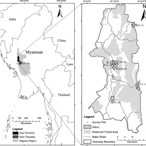

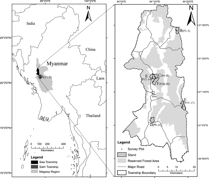