![]()
Advance Publication
Accepted: May 2, 2024
Published online: August 1, 2025
Contents>> Vol. 14, No. 2
The Palaeogeographic Evolution of the Wonosobo Volcanic Area and Its Impacts on Ancient Life in the Cradle of the Javanese Civilization
Suhadi Purwantara*, Arif Ashari**, Kuncoro Hadi***, Eko Prasetyo Nugroho Saputro†
*Department of Geography Education, Universitas Negeri Yogyakarta, Colombo Street 1 Yogyakarta, Yogyakarta Special Region 55281, Indonesia
Corresponding author’s e-mail: suhadi_p[at]uny.ac.id
![]() https://orcid.org/0000-0001-9953-2215
https://orcid.org/0000-0001-9953-2215
**Department of Geography Education, Universitas Negeri Yogyakarta, Colombo Street 1 Yogyakarta, Yogyakarta Special Region 55281, Indonesia
e-mail: arif.ashari[at]uny.ac.id
![]() https://orcid.org/0000-0003-2028-6125
https://orcid.org/0000-0003-2028-6125
***Department of History Education, Universitas Negeri Yogyakarta, Colombo Street 1 Yogyakarta, Yogyakarta Special Region 55281, Indonesia
e-mail: hkuncoro[at]uny.ac.id
![]() https://orcid.org/0009-0004-3696-8213
https://orcid.org/0009-0004-3696-8213
†Department of Communication Science, Universitas Negeri Yogyakarta, Colombo Street 1 Yogyakarta, Yogyakarta Special Region 55281, Indonesia
e-mail: ekoprasetyo[at]uny.ac.id
![]() https://orcid.org/0000-0002-6107-9002
https://orcid.org/0000-0002-6107-9002
DOI: 10.20495/seas.25004
Browse “Advance online publication” version
This paper investigates the palaeogeographic evolution of the Wonosobo Volcanic Area (WVA) of Central Java, Indonesia and its impact on ancient human life beginning from the Ancient Mataram era of the seventh-eighth centuries. Primary observations conducted across nine zones of three distinct volcano units were cross-referenced with existing geological and topographical maps and relevant secondary literature to create a chronology of landform evolution. Traces of past life were found spread throughout the WVA. In the Sundoro Stratovolcano area, which was still experiencing activity in the time of Ancient Mataram, volcanic eruptions were disastrous, with evidence of at least one settlement buried. But in the Sumbing and Dieng Volcanic Complex areas, which have been inactive for two-three centuries, the impact of volcanism on human life is not as apparent. Instead, the denudation process, exacerbated by the climate conditions, is more influential, as evidenced by various archaeological relics that are buried in alluvial material. This study provides alternative information about the contribution of natural factors in influencing the dynamics of life in Ancient Mataram. This study also offers new insights into the influence of palaeogeographic changes on human-environment interaction on a long temporal scale.
Keywords: palaeogeography, volcanic landform, Ancient Mataram, Central Java
Introduction
Since ancient times, volcanoes have been at the heart of—and the inspiration for—civilizations due to their natural resource potential and the social-spiritual benefits of the human-volcano relationship (Sutikno et al. 2007; Bachri et al. 2015). But little is known about the evolution of volcanic landforms and its influence on ancient life. What natural processes are involved in this evolution and how have they impacted the way people live with the environment?
Indonesia offers the ideal place for such an inquiry. Active volcanoes are a primary feature of the Indonesian landscape, as indicated by the large number distributed across various regions of the country. Globally, Indonesia is home to no less than 13 percent of the world’s active volcanoes, making it the country with the highest level of volcanism (Zaennudin 2010; Verstappen 2013). According to historical records, 47 percent of eruptions in Indonesia have occurred on the island of Java. Volcanoes have been active since the beginning of the island’s formation in the Eocene Epoch (Hall 2009) and eruptions are expected to continue to evolve naturally over time given Java’s geological conditions (Verstappen 2010). Volcanic landforms and mountains account for 60 percent of Java’s land cover (Hadmoko et al. 2017), with stratovolcanoes the most common morphological type (Ashari and Purwantara 2022).
As an essential landform of Java, volcanoes have been the center of ancient civilizations on the island. Lavigne et al. (2008) explain that volcanic slopes have been occupied by people for thousands of years. Most of Degroot’s (2009) findings of hundreds of temple relics in Central Java are in the volcanic landscape compared to other regions. Indeed, the Borobudur and Prambanan temple compounds, referred to as the ancient capital are between two volcanoes. But volcanic activity has also ruined civilizations: the ancient village site of Liyangan on the eastern slope of Sundoro Stratovolcano (Riyanto 2015) and the Asu Temple Complex on the western slope of Merapi Stratovolcano (Ashari 2013) were both buried by pyroclastic material. Thus, the evolution of volcanic landforms has been an essential factor in determining the emergence, development, and disappearance of ancient civilizations on Java.
The influence of landform evolution on life has long been studied. Wang and He’s (2022) study on fluvial stretches demonstrated that human life is closely related to the evolution of rivers. Similarly, Lu et al. (2019) and Ashari (2022) found that the evolution of the fluvial landscape has impacted ancient settlements. The research of Ghilardi et al. (2017) details how the slow evolution of landforms has allowed human civilizations to develop longer, resulting in various forms of cultural remains. In contrast, when landscape changes suddenly occur, the impact on civilizations is more severe. In their study of a piedmont area, Zhang et al. (2022) proved that the evolution of land that caused flood fixation provided opportunities for the development of a more advanced civilization. These studies provide insight into the close relationship of landscape evolution to human life and culture. Slow change provides a stable environment for cultural development. On the other hand, massive changes can trigger disasters that hinder or even eliminate a culture.
The particular influence of volcanic landscape dynamics on human life has also received significant attention. However, previous studies tend to focus on catastrophic events, instead of gradual evolution over a longer temporal scale. A single catastrophic event can cause a direct impact on human civilization, such as the burial of Pompeii by the eruption of Vesuvius in 79 CE (Sheets 2015) or the burial of the three kingdoms on Sumbawa Island by the eruption of Tambora in 1815 (Sutawidjaja et al. 2006). Volcanic eruptions can also affect conditions in the global atmosphere, which then affect human life across a wider area, as happened in the eruption of Krakatoa in 1883 (Schröder 2002) and Tambora in 1815 (Wood 2015). Unlike these studies, however, this research elaborates on the impact of various events related to the evolution of the volcanic landscape over a longer time frame.
Volcanic landforms can evolve both through eruptions and denudation processes controlled by exogenous forces. To investigate the natural processes involved in this evolution and the impact of they have had on human life over time, this study focuses on the Wonosobo Volcanic Area (WVA) in Central Java. The WVA is dominated by three main volcanic morphologies, namely the twin Sumbing and Sundoro stratovolcanoes and the Dieng Volcanic Complex (DVC). This region is known as the cradle of the Javanese civilization (Degroot 2009) and has been inhabited for thousands of years, during which time numerous natural processes have changed the land conditions.1) In examining the paleogeographic evolution of the WVA and its impact on human life, this study provides new information about the role of natural factors in the dynamics of Ancient Mataram and new insights into the influence of palaeogeographic changes on human-environment interaction in ancient times.
Methods
The Study Area
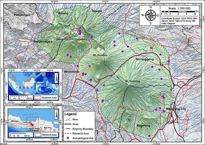
The study was carried out across the Wonosobo Volcanic Area (WVA), where volcanic features align along a SE-NW axis with Sumbing Stratovolcano in the southeast, Sundoro Stratovolcano in the middle, and Dieng Volcanic Complex (DVC) in the northwestern quarter of the area (Fig. 1). Administratively, the research area spans six regencies in Central Java Province with a total area of 1,326 km2 (Fig. 1). Three large rivers originate from the WVA, namely the Serayu (181 km long), the Progo (138 km long), and the Bogowonto (67 km long), thus it plays a vital role in the hydrologic system of Central Java.
Data Collection and Analysis
The study area is divided into nine zones. The Sumbing and Sundoro stratovolcanoes are each divided into four zones to represent all slope sectors, namely SE, SW, NW, and NE. Meanwhile, the DVC is classified as a separate zone (Fig. 2). In each zone, observations were conducted to obtain primary data on the geological and geomorphological conditions, archaeological sites, toponyms, and other traces of past life. The largest number of observation points is in the DVC, with nine locations spread throughout the DVC volcano complex. Observations were carried out to obtain primary data on the geological and geomorphological conditions to estimate the genesis and create a chronology of landform evolution in the WVA. We applied Verstappen’s method (2014) to conduct a geomorphological-synthetic survey.
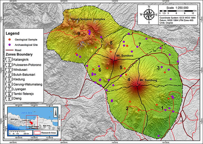
Fig. 2 Zoning for Analysis Based on the Physiographical Unit of the Study Area
Source: Indonesia Topographical Maps; Degroot 2009; Sukronedi et al. 2018
Meanwhile, secondary data was interpreted. Existing remote sensing images were sourced for data on geomorphologic conditions. Relevant literature was reviewed for pertinent historical and archaeological facts as well as relevant information about landform evolution and community life in Ancient Mataram era (Table 1). Finally, geological data was acquired from geological maps and geomorphological data from Indonesian Topographical Maps (Geospatial Information Agency of Indonesia 2000). This data was cross-referenced to create a chronology of landform evolution, as depicted in Figs. 3 and 4. Descriptive data analysis was supported by GIS analysis using average nearest neighbor and buffering.
This study combines a geographic and historic approach. A descriptive analysis was employed to better understand the chronology of natural events in the past and thus paint a picture of landform evolution. To construct the chronology, we begin with careful observation of existing geomorphologic conditions and rely on the basic concept of “the present is the key to the past.” There are four stages to this analysis (Table 2). To better understand past life in the study area, a four-step historical analysis was employed: source collection (heuristics), source critique (verification), interpretation, and writing (historiography).
Table 1 Data Types, Data Collection Techniques, and Data Instruments/Sources
| No | Variables | Data Collection Techniques | Instruments/data Sources |
|---|---|---|---|
| 1. | Geomorphological conditions: – Morphography – Morphometry – Morphogenesis – Morphocronology – Morphoarrangement |
Observation | Observation sheets, GPS, geological compass, abney level, roll meter, digital camera |
| Remote sensing image interpretation | Landsat 8 OLI Imagery and Google Earth Engine | ||
| Document analysis | Indonesian Topographical Map (Geospatial Information Agency of Indonesia 2000), Sheets on Wonosobo, Parakan, Temanggung, Kertek, Kaliangkrik, Magelang, Watumalang, Batur, and Kejajar | ||
| Literature study | Ashari (2014; 2019) | ||
| 2. | Geological conditions: – Lithology – Stratigraphy |
Observation | Observation sheets, GPS, geological hammer, geological compass, digital camera |
| Document analysis | Indonesian Geological Map, Sheets on Magelang-Semarang (Thanden et al. 1996), and Banjarnegara-Pekalongan (Condon et al. 1996) | ||
| Literature study | Harijoko et al. (2010; 2016) | ||
| 3. | Historical and archaeological remains | Literature study | Riyanto (2015; 2017), Tanudirjo et al. (2019), Sukronedi et al. (2018), Santiko (2013) |
| 4. | Toponyms and local wisdom | Literature study | Sukronedi et al. (2018), Lavigne et al. (2008) |
Table 2 Landform Evolution: Four Stages of Analysis
| Stages | Analysis Procedures |
|---|---|
| Stage 1 | Describe all the geomorphologic aspects of existing landforms, including the morphology, materials, geomorphologic processes, genesis, climate, and tectonics, using the combined methods of King, Davis, Penck, and Verstappen (as explained in Huggett 2017; Pramono and Ashari 2014). |
| Stage 2 | Interpret the genesis and development of landforms based on the concept of “the present is the key to the past,” recognizing that current geomorphological conditions are the result of past processes. This process is supported by the interpretation of various types of rock formations in the study area. |
| Stage 3 | Apply the basic concepts of geomorphology to ensure the accuracy of the interpretation. |
| Stage 4 | Examine secondary data to confirm absolute dating. When this is not possible, determine chronological events by performing relative dating. |
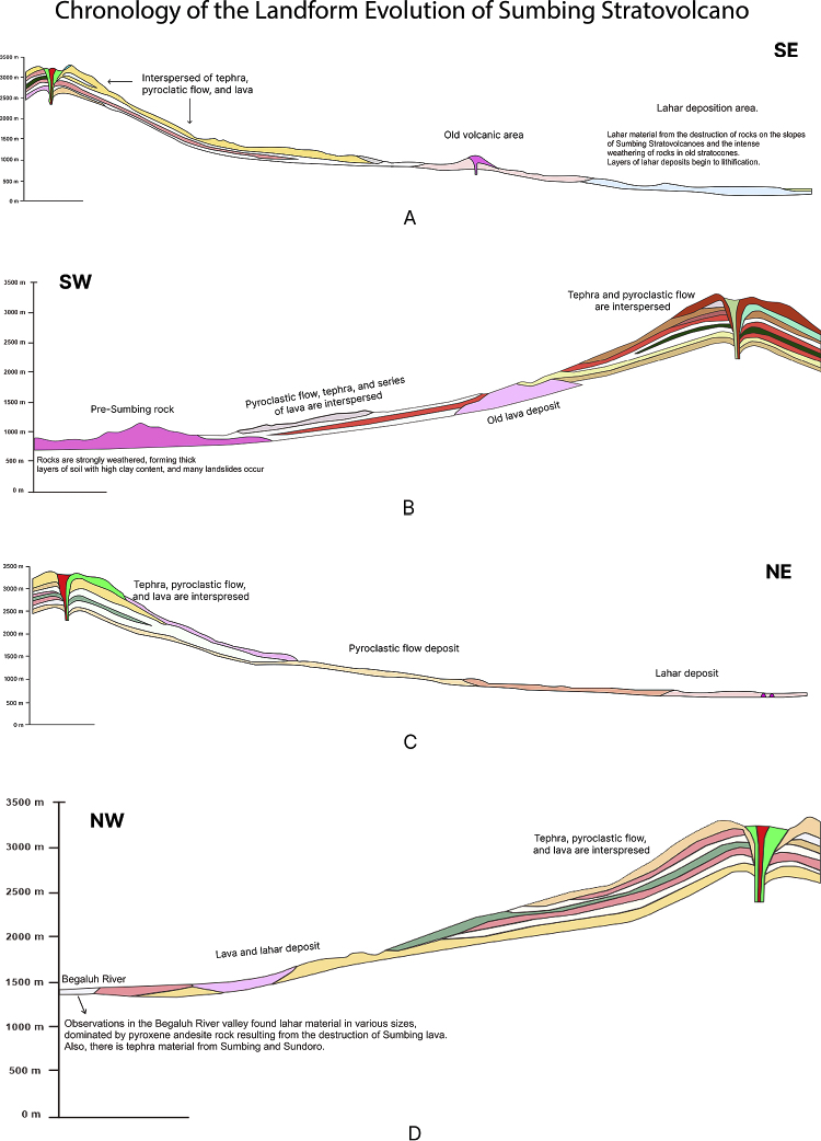
Fig. 3 Reconstruction of Paleoeruption Affecting the Evolution of Landforms in Sumbing Volcano. (A) SE side, (B) SW side, (C) NE side, and (D) NW side
Source: Sitorus et al. 1994
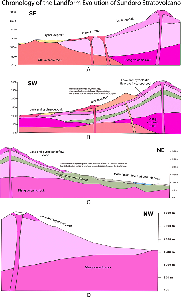
Fig. 4 Reconstruction of Paleoeruption Affecting the Evolution of Landforms in the Sundoro Volcano. (A) SE side, (B) SW side, (C) NE side, and (D) NW side
Source: Sukhyar et al. 1992
Results
1. Physiographic Conditions and Paleogeographic Evolution of the Wonosobo Volcanic Area
(1) Sumbing Stratovolcano
Sumbing is a stratovolcano in the southeast of the WVA with a height of 3,371 masl. According to the Center of Volcanology and Geological Disaster Mitigation (CVGDM) of the Republic Indonesia (2014a), the crater lip of the northeastern part of this volcano was destroyed by the eruption. It looks torn, or split, and hence was given the name Sumbing, meaning “chipped.” The Cultural Heritage Conservation Center (locally known as BPCB) of Central Java Province provides a different explanation, wherein the name Sumbing comes from Wukir Sumving, which was the name for Sumbing Volcano in the Ancient Mataram era, as referenced in the Mantyasih I Inscription of 829 Çaka, or 907 CE (Sukronedi et al. 2018).
Sumbing is unique in that it has a perfect cone shape that is divided into three sectors, as explained by Verstappen (2013). These are: the cone (tip) as the first sector, the slope as the second sector, and the foot as the third sector. Each sector is distinguished by a break, or sudden change, in slope. Sumbing’s constituent rocks are andesite, basalt, and dacite. The CVGDM (2014a) explains that Sumbing experienced an eruption in 1730 CE, which created a peak crater with a lava dome and lava flowed toward the lowest crater lip. Lavigne et al. (2008) confirm that: 1) the eruption in 1730 CE formed the lava dome that exists today and 2) a pyroclastic flow formed due to collapse in one part of the dome. According to Suhendro et al. (2024), Sumbing has experienced seven explosive eruptions. All eruptions occurred between 27.4 Ka and 1.1 Ka, meaning that there have been no major explosive eruptions in the last 9,000 years.
Sumbing’s slopes exhibit complex physiographic conditions. The SE zone is formed by a protracted volcanism marked by a diverse array of eruptions. Tephra deposits are 30 meters thick and spread across the slope and foot sectors. Following the deposition of this tephra, a 25-meter-thick pyroclastic flow was deposited. The youngest material is a 12-meter-thick andesite lava flow that extends in a narrow strip. The evolution of the landform in the SE zone began with the emergence and activity of Mount Kekep during the first period of Sumbing activity. Subsequent volcanic activity formed Mount Giyanti and Mount Condong in a second period. Finally, the cone of Sumbing Stratovolcano was formed in the third period of activity. Overall, this zone was the most affected by the Sumbing eruption from the first period to the last (Fig. 3A).
Material on the SE slopes of Sumbing Volcano consists of lahars sourced from rock disintegration on the upper slopes of Sumbing and weathered rocks from various old stratovolcano units. Observations from various sample locations in the field indicate that deposits from these various sources have mostly lithified, forming more solid and hard layers.
The SW zone of Sumbing was formed from explosive eruptions that produced tephra deposition and pyroclastic flows, preceded by effusive eruptions that produced andesite lava. This zone is relatively older than other parts of Sumbing’s slopes. The chronology of landform evolution in this area is divided into three periods. The first period occurred during the transition between the Tertiary and the Quaternary periods of the Pleistocene Epoch and is marked by the formation of Potorono Hill. In the second period, Namu-Namu Lava was deposited. Finally, in the third period, multiple eruptions produced (in chronological order): pyroclastic flow, tephra, lava, another pyroclastic flow, and a lava deposit interrupted by the deposition of pyroclastic flow (Fig. 3B). Potorono Hill has experienced advanced weathering. Field observations establish that rock weathering in this area has formed thick layers of sticky and clay-like soil and relatively rare rock outcrops. This advanced soil layer significantly affects the geomorphic processes on Potorono Hill, causing numerous mass movement events, especially of the slide type.
The rocks in the NE zone of Sumbing demonstrate that the eruptions have been dominated by explosive events interspersed with effusive periods that resulted in the deposition of lava material. This zone is generally related to the youngest activity of Sumbing, in which tephra and pyroclastic flows are interspersed with lava. This zone exhibits ideal stratovolcano conditions (Sutikno et al. 2007; Verstappen 2013), where lava deposition is limited to the volcanic cone area, pyroclastic deposition extends to the volcanic slopes, and the lowest foot sector is filled with lava deposits (Fig. 3C).
The NW zone of Sumbing also exhibits the distinct characteristics of a composite volcano formed by alternating explosive and effusive eruptions. Explosive eruptions are marked by ash-lapili-sized tephra material and pyroclastic flows, while the effusive eruptions are marked by lava flows. The lithology of this zone is quite complex, consisting of lava deposits, pyroclastic flows, and tephra. The pyroclastic flow deposits are 25 meters thick and are 27,400 (± 550) years old, while the lava deposits are 20 meters thick. Interestingly, there are 5-meter-thick tephra deposits from Sundoro at the volcanic foot. All volcanic activity in this zone is from the third period of Sumbing and is therefore young (Fig. 3D).
Our findings from observations in the Begaluh River valley, on the northeast side of Sumbing Volcano, indicate scattered lahar material of various sizes, predominantly composed of andesite rocks. Because this river serves as the drainage system for the junction of Sumbing and Sundoro stratovolcanoes, the lava material found in the valley are products of the eruptions of these two volcanoes. The lahar deposits are dominated by light gray disintegrated pyroxene andesite from Sumbing. Additionally, there is also smaller-grained disintegrated pumice material with sharp edges, from both Sumbing and Sundoro.
In the absence of eruption data during the post-colonial era, it can be assumed that most eruption events occurred before this period. Lithological and stratigraphic evidence demonstrates that volcanic activity took place over a long period and impacted different zones of the cone, slope, and foot of Sumbing differently. The earliest volcanic event formed rocks in one specific zone (the SE), as did the last volcanic event (in the NW zone). A parasitic cone at the foot of Sumbing is the center of distinct volcanic activity that is older than the Sumbing Volcano itself, instead of a flank eruption.
Radial valleys have formed on the slopes and foot of Sumbing. Valley morphometry is characterized by deep valley bottoms and steep valley slopes. These radial valleys are found on all sides of the volcano, indicating that the denudation process has taken place towards the Sumbing cone structure. The intensive denudation process is evidence that the volcanism process no longer balances the denudation process; thus, the morphology of the stratovolcano cone is modified by the formation of radial valleys. This process increases the risks of erosion, sedimentation, and mass movement events, which are now of more concern than volcanic eruptions.
The geological map of Sumbing Volcano (Sitorus et al. 1994) shows how these hazards have changed. Eruptions were a threat in very ancient periods, as indicated by the presence of aged pyroclastic materials and lava. Meanwhile, the youngest materials are colluvium and alluvium, which do not interleave with volcanic products and are products of denudation processes caused by exogenous forces. Thick layers of colluvium and alluvium material are the result of long-standing erosion-deposition processes and mass movement events, both of which have threatened the human population over the past few centuries.
The paleogeographic evolution of Sumbing Volcano can be outlined as follows: a stratovolcano morphology was constructed during the Quaternary period, followed by the destruction of this morphology by exogenous forces of the wet tropical climate, a process that has increased since the last eruption in 1730 CE. Morphological development in Sumbing began with pre-Sumbing volcanism in the southeast and southwest, followed by the formation of stratovolcano morphology through a series of alternating effusive and explosive eruptions. Since the last volcanic eruption, a denudation process has begun that continues today. Compared to other volcanic units in the WVA, Sumbing Volcano is the most denuded.
(2) Sundoro Stratovolcano
Sundoro is just northwest of Sumbing and close enough that the two are referred to as twin stratovolcanoes by Lavigne et al. (2008). Sundoro has a height of 3,153 masl, with a perfect cone shape known as one of the most symmetrical morphologies on Java Island. Its concave slope is divided into three sectors bounded by slope notches, which are commonly found in stratovolcano morphology. Some of the local community refer to Sundoro as Sindoro, while the ancient name referenced in the Mantyasih I Inscription is Wukir Susundara (Sukronedi et al. 2018).
Sundoro has a history of more eruptions than Sumbing. According to the CVGDM (2014b), eleven major eruptions occurred between 1806 and 1970. These eruptions tended to produce ash rain, material throwing, and lava flows a short distance from the eruption center, whether that was the main crater of Sundoro or the parasitic cone of Mount Kembang. The last increase in volcanic activity occurred from 2011–12. According to Prambada et al. (2016), Sundoro experienced 12 major eruptions, referred to as eruptive groups, ranging from 33,619 cal BP (~34 Ka) to the last at 515–453 cal BP. The CVGDM has established an observation post to monitor the volcanic activity of the twin stratovolcanoes, but considering the greater threat of Sundoro compared to Sumbing, the post is on the northeast side of the foot of Sundoro. Few locals are aware of the potential hazards of the volcano because the phreatic eruptions that occur periodically in the Sundoro crater are too small for the residents to notice (Lavigne et al. 2008).
Sundoro is composed of the same main rocks as Sumbing, with the exception of dacite, which is absent. Examination of the geological map of Sundoro Volcano (Sukhyar et al. 1992) produces two important findings. First, tephra material is widely and evenly distributed throughout Sundoro’s slopes. This is evidence that the explosive eruptions that occurred in the main crater spread out evenly and were not directed at a certain zone. In addition, there are 1,720-year-old pyroclastic deposits in all zones of Sundoro’s slopes. Second, material from the Sundoro eruptions is also distributed across a large area of the slopes of Sumbing. This indicates that these two nearby volcanoes experienced different periods of activity. Sumbing was active first and was no longer significantly active when Sundoro was at the peak of its activity.
Exogenous-induced geomorphic processes in Sundoro predate those in Sumbing. Radial valleys are not significant on the slopes or feet of Sundoro. In other words, the Sundoro stratovolcano cone has not been modified much by the formation of radial valleys due to exogenous forces. Morphometrically, the radial valleys that have been formed do not have deep valley floors or steep slopes as in Sumbing. This condition is due to Sundoro’s recent volcanic activity, which balances the effects of the denudation process. Given this geomorphic status, Sundoro still faces the threat of eruption while Sumbing faces threats of erosion, mass movement events, and sedimentation.
The physiographic conditions of each Sundoro slope are as complex as Sumbing. The SE zone of the Sundoro cone is based on a foundation of Dieng volcanic rock. Activity in this area is characterized by repeating effusive and explosive eruptions. A series of four lava flow deposits is interspersed with tephra deposits. On the SE slope, lava deposits are covered by a layer of tephra that is more than 8 meters thick. Meanwhile, in the SE foot, lava deposits (as the oldest material) are buried by 1,720-year-old pyroclastic flow deposits that are more than 4 meters thick (Fig. 4A).
The SW zone of Sundoro is based on a foundation of Dieng volcanic rocks and old Pagerluhur rocks. This zone was formed by a central eruption and three subsequent flank eruptions. The first flank eruption formed the Watu Parasitic Cone, the second formed the Kembang Parasitic Cone, and the third formed the Kekep Parasitic Cone. Therefore, the overall geochronology of this area is characterized by the formation of the main volcanic cone and subsequent parasitic cones. Following the formation of the main cone, magma activity broke through its slope to form parasitic cones. The first magma breakthrough caused the flank eruption that formed Mount Kembang. After it was formed, Mount Kembang underwent a breakthrough that formed Mount Kekep. The last breakthrough formed Mount Watu. Mount Kembang is an active parasitic cone that produces lava material and ash rain (Fig. 4B). Field observations revealed various parasitic cones on the southwest side of Sundoro that form a distinctive hill morphology not found in other parts of Sundoro Stratovolcano. Similarly, the deposits of a 1,720-year-old pyroclastic flow form an elongated edge morphology from the volcano’s foot to the volcanic foot plain in a certain part of the southwest zone of Sundoro.
The NE zone of Sundoro is also formed from alternating explosive and effusive eruptions. Explosive eruptions are marked by the presence of widespread tephra deposits and pyroclastic flows that form thick deposits, especially on the slopes. Effusive eruptions are marked by several lava deposits and lava domes that dominate the volcanic cone area. On the NE slope and foot, we find rock outcrops with pyroclastic flow and tephra material deposition, around the Liyangan Site. This material buried the Ancient Village of Liyangan and thus, the eruption is assumed to have occurred later than the eighth century (Fig. 4C). Observations conducted at the Liyangan Site, in the transition area between the volcanic foot and slope, yielded findings of several outcrops indicating tephra layering. This suggests that the tephra material encompassing the entire NE side of Sundoro, as indicated on the geological map (Sukhyar et al. 1992), is a product of explosive eruptions that occurred repeatedly during the Quaternary period. This is further indicated by the tephra’s thickness, which is approximately 10 cm in each layer.
The width of the NW side of Sundoro is limited by the structure of the Telerejo volcano to the north. The NW zone was formed by a lava-dominant deposition, which formed lava bands that flowed north until colliding with the Telerejo morphology and then flowing northeast. Meanwhile, the pyroclastic flow moved towards the northwest and was deflected by Telerejo’s morphology. The geochronology in this zone is therefore mostly related to lava flows. The morphology of the base of the volcano has not developed because it is directly adjacent to the Telerejo volcano and forms a plain between the volcanoes (Fig. 4D).
As a stratovolcano, Sundoro’s evolution is comparable Sumbing’s in that it also experienced the formation of stratovolcano morphology followed by endogenous force destruction. However, the evolution in Sundoro differs from Sumbing in at least two respects. First, the landform evolution in Sundoro did not begin with a pre-Sundoro eruption, like the eruption that formed Potorono Hill on Sumbing. Instead, the various parasitic cones present are products of flank eruptions that interleaved the stratovolcano morphology through alternating explosive and effusive eruptions. Second, this volcano remains relatively active and its explosive-effusive eruption activity is the most recent in the WVA compared to Sumbing and Dieng. Therefore, this volcano is the least denuded. Erosion and mass movements are minimal, and as a result, the formation of radial valleys is relatively limited compared to other volcanic units in the WVA.
(3) Dieng Volcanic Complex (DVC)
The DVC is a prominent volcanic complex in Indonesia and it occupies the northwestern quarter of the WVA. Verstappen (2013) explains that the DVC is a group of small to medium-sized volcanic features that developed in the caldera of an old volcano. The caldera frame is formed from the ruins of the southern slope of Mount Prahu. This structure was previously interpreted as a caldera with only its northern part remaining. However, since the DVC is located above the intersection of faults, it is possible that this arc structure was formed due to a volcano-tectonic collapse. The most recent Holocene volcanic activity was experienced in the southern part of this caldera cliff. Young and active volcanoes in the Dieng complex have produced a variety of volcanic landforms, including eruption craters, tuff ring craters, scoria cones, small stratovolcanoes, and lava flows. In general, eruptions in this area vary from explosive to effusive and phreatic (Verstappen 2013; Harijoko et al. 2016).
The DVC consists of 12 volcanic units and four volcanic units bordering the DVC. Prahu, which is 3.6 Ma, is the oldest volcano in the complex, followed by Nagasari (2.99 Ma), Bisma (2.53 Ma), Pangonan–Merdada (0.37 Ma), Kendil (0.19 Ma), Pakuwaja (0.13 Ma), and Seroja (0.07 Ma). Volcanic activity in the DVC is generally divided into three stages, namely the pre-collapse episode, the second episode, and the youngest episode. The pre-collapse episode is represented by several stratovolcanoes on the edge of the DVC, namely Prahu, Telerejo, Sidede, Bisma, Nagasari, and Jimat. All these stratovolcanoes consist of pyroclastic deposits and lava flows (Verstappen 2013; Harijoko et al. 2016). Telerejo and Bisma have open craters towards the south. According to Bronto et al. (2014), the open horseshoe crater of Bisma Volcano is a symptom of the collapse of one of the stratovolcano’s slopes.
In the second episode, namely Pangonan-Merdada, Bucu, and Pagerkandang created several stratocones and covered the caldera with volcanic products. The activity of this second episode is believed to be the main source of the Dieng tephra, which covers the Dieng and Batur depressions. Furthermore, the youngest episode, in the southeast area of the DVC, created several volcanic cones, including Seroja, Prambanan, Sikunir, Pakuwaja, and Kendil. Recent activity in the DVC is marked by phreatic explosive events. Several volcanic events recorded since the eighteenth century occurred in geothermal areas such as Sileri, Pakuwaja, Sikidang, and Candradimuka (Harijoko et al. 2016). Geomorphologically, the slopes of the oldest stratocone units, formed during the first episode, have significantly eroded, resulting in wide and deep radial valleys. Prahu and Bisma Volcano, the two oldest units, clearly exhibit denudation processes. Meanwhile, younger stratocone units, especially those composed of hard lava like Pakuwaja, still maintain their morphology and are unaffected by erosion.
The volcanic activity in the DVC has been both explosive and effusive. Currently, the geomorphic process in Dieng is dominated by exogenous denudation on various volcanic structures. Observations in the area of Bisma and Seroja volcanoes attest that the denudation process has begun to strengthen, leading to the formation of deep radial valleys, especially in Bisma, which is older. Thick alluvium, formed from the deposition of weathered material eroded off the caldera slopes, is found in Bisma’s horseshoe crater. The denudation process has also begun in the younger Seroja volcano, marked by the occurrence of mass movement events. In addition, a deposit of debris in one of the sectors of Bisma volcano is formed from parts of the volcano’s body that collapsed during an eruption.
On the slope and the foot of Prahu Volcano that have subsided, lava material from the activity of Prahu was buried by the Dieng tephra. When this happened, tephra deposits began to be heavily layered by alluvium eroded from the volcanic slopes. Likewise, tephra material and lava, some of which is extremely weathered, are found throughout the Pagerkandang, Prambanan, Sikunir, and Pakuwaja areas. Materials from the volcanic activity of Pangonan and Merdada are currently eroding in the Pangonan Volcano area and are being deposited as alluvium in the Dieng Depression.
The Dieng Volcanic Complex (DVC) is a different volcanic unit compared to Sumbing and Sundoro. The DVC is not a single stratovolcano, but rather a volcanic complex containing dozens of small to medium-sized stratocones. As a volcanic complex, the landscape evolution also differs from the other two units. Landform evolution in the DVC began with the formation of several stratocone units in one area. Subsequently, a volcano-tectonic process occurred, causing subsidence on one of the stratocone slopes, a phenomenon not found in other volcanic units of the WVA. The stratocones then experienced explosive eruptions, forming a crater morphology. Finally, effusive eruptions resulted in massive stratocone units. All these processes occurred before human habitation. At present, denudation processes dominate the landscape. Because the stratocone units have different ages, the impact of denudation on modifying the stratocone slopes also varies. Older stratocones tend to be more eroded because they have undergone advanced weathering and have been exposed to denudation influences for a long time, even though they are composed of an immense amount of lava. Because mass movement events and erosion now dominate the DVC, the local population is more familiar with these processes, rather than volcanism, as threats.
2. The Impact of Paleogeographic Evolution on Ancient Life in the Wonosobo Volcanic Area
(1) A Brief History of the Ancient Mataram Kingdom and the Three Sacred Volcanoes
The oldest evidence of an Ancient Mataram kingdom is widely believed to be the Canggal Inscription dated 732 CE, which documents the establishment of a linga on Sthirangga Hill and the name of Sanjaya as ruler (Poerbatjaraka 1951; Poesponegoro and Notosusanto 2010; Santiko 2013). Sanjaya’s name is an important indication of the existence of Ancient Mataram because the name is related to the identity of the region in the Mantyasih I Inscription of 907 CE. The name Medang (or Mdang) was used interchangeably with Mataram in inscriptions, and both names were referred to in the Bujangga Manik manuscript of the late sixteenth century (Noorduyn 2019).
The spread of archeological findings from the Ancient Mataram period in Central Java points to the plains of Kedu and Kuwu (Prambanan), which are surrounded by mountains, as the center of the civilization. This region became the core area of a government supported by the peripheries. The core area included the villages (wanua) and the larger administrative regions (watak) of Merapi, Merbabu, Sundoro, and Sumbing, where there were many sacred buildings. This core area was supported by the wanua and watak around Mount Dieng, Ungaran, and the southern hills, which were important peripheral areas (Tjahjono 2008; Degroot 2009).
Sanjaya is considered to be the early ruler of the ancient kingdom of Mataram in Central Java. However, several other inscriptions from the eighth and ninth centuries refer to Sailendra as the ruler as well as a dynasty in ancient Mataram.2) Regardless of whether there was one or two dynasties in Ancient Mataram in the Central Java period, the names of the rulers, emperors, and rulers of autonomous regions from the inscriptions demonstrate that the territory under their control spread across the Kedu-Kuwu plain. The Kedu plain lies between the present-day Sumbing and Sundoro stratovolcanoes, and included the interconnected territories of Garung, Wungkalhumalang (or Watuhumalang), and Patapan. Thus, the Ancient Mataram kingdom first emerged in the seventh-eighth centuries from the Kedu region (Lombard 1996a). Indeed, as Boechari (2012) explains, a road through the Kledung gap once connected the Kedu plain with Wonosobo, penetrating Garung and Dieng to reach the north coast.
According to the sixteenth-century manuscript Tantu Panggelaran, Mount Dieng was an important holy place where Bhatara Guru went to meditate and ask Lord Brahma and Vishnu to bless residents. Dieng is interpreted as a mountain area where the gods reside (Lombard 1996b). The name Dieng, whose original form is Di Hyang, symbolizes the Sanskrit word Devälaya, which means “the abode of the gods” (Coedès 1975). Zoetmulder (1983) mentions the mountains as places with actively inhabited villages close to holy buildings/hermitages during the Hindu-Buddhist period. The names of Mount Dieng (or Diheng), Sindara (or Sundara/Sundoro), and Kedu (Sumbing) are also mentioned in the late fifteenth-century literary work Bujangga Manik as inhabited holy places (Noorduyn 2019).
These three sacred mountains, Dieng-Sundoro-Sumbing, are also recorded in the Kuti Inscription of 840 CE. In this inscription, the name Śataśṛngga is referenced, which may be close to Dieng. Śataśṛngga is also referenced in the Tělang II, or Wanagiri II, Inscription of 904 CE, as well as Randusari I, or Poh, Inscription of 905 CE, as the burial place of an emperor, or “mahārāja lumāḥ ing çataçṛngga.” In the Mahabarata epic, Satrasrengga (or Saptaarga) is the hermitage of Begawan Wiyasa. The portrayal of the mountainous region as a place of sacred buildings as well as inhabited villages is supported by the Randusari I Inscription, which refers to the guardian of the sacred building Marhyang in the village of Sima and the guardian of the emperor’s sacred territory in Çataçṛngga (Stutterheim 1940; Suhadi and Soekarto 1986; Poesponegoro and Notosusanto 2010).
(2) Signs of Ancient Life Impacted by Paleogeographic Evolution
Sumbing has not experienced eruption activity, either explosive or effusive, for hundreds of years. Today, Sumbing’s volcanic activity consists of gas emissions limited to the crater area. Although the only recorded eruption in history is the lava flow that occurred around the peak crater, this does not mean that Sumbing’s volcanic activity since the Ancient Mataram era has not had a significant impact on human life. In the case of Sumbing, impacts have been caused by the denudation of the stratovolcano morphology, instead of volcanic eruptions.
There are fewer traces of archaeological remains in the Sumbing region than in other regions of the WVA. Various archaeological findings are concentrated in the NE zone of Sumbing, which is close to the center of Ancient Mataram in the Kedu/Progo Valley area. The archaeological sites include the following temples and temple complexes: Selogriyo, Batur, Wonokerso, Brongkol, Pikatan, and Gondosuli. Findings from these sites are essentially a part, or a continuation, of findings from sites in the Sundoro region. The only archaeological site found outside the NE zone of Sumbing is Rong cave, in the SE zone.
Of the temple findings, Selogriyo Temple has been restored and the superstructure remains intact, although the foundation is misshapen. This is evidence that the area has not experienced severe affects from drastic natural processes. Although the height of the temple is relatively close to Sumbing’s, the structure remains relatively intact in all parts. No part of the temple was lost in the main Sumbing eruption, as happened at several sites in the Sundoro region and the Asu Temple Complex at the foot of Merapi, which is far east of the WVA (Ashari 2013). Giyanti Massif, a nearby old and inactive volcano, has played a role in protecting Selogriyo Temple from Sumbing’s eruptions. Batur Temple, which is on one of the peaks of Giyanti Massif, is not buried by volcanic material and retains its foundation, although the top of the peak has been flattened to form a wide space.
Gondosuli Temple Complex spans hundreds of kilometers and contains temples that are not in situ. Findings in the complex include a sculpture of a bull, a large yoni, nine stone pedestals, and the Gondosuli Inscription dated 827 CE. The Gondosuli Temple site is currently located slightly lower than the surrounding land, but it is not significantly buried. Various former temple components are buried by the deposition of alluvial sediments because the complex is at the foot of the volcano, where eroded material from the upper slopes tends to deposit. Meanwhile, only ruins and traces of foundations remain of the other three temples, namely Wonokerso, Brongkol, and Pikatan. However, there have never been any reports or findings indicating that the destruction of these temple structures is due to an eruption. In summary, the archaeological sites in the Sumbing area do not exhibit damage due to the impact of explosive eruptions, but rather, due to the dynamics of the exogenous processes such as erosion and deposition of alluvial material.
Unlike Sumbing, Sundoro is the most active among all volcanic landform units in the WVA. Although present activity is not substantial compared to, for example, Merapi Stratovolcano, which 56 km to the east, Sundoro is the volcano to have experienced the most recent explosive eruption in the WVA. Sundoro has not only experienced a major eruptions centered on the main crater, but also flank eruptions that produced parasitic cones. Thus, the evolution of landforms by volcanism potentially influenced human life during the Ancient Mataram period in numerous ways.
Tephra material and pyroclastic flow have been deposited evenly throughout the Sundoro area for the past 1,720 years. At the same time, a pyroclastic flow in the northern zone descended the northern slope and was diverted NE when it was blocked by the Telerejo volcano structure. The volcanism process that deposited tephra material, pyroclastic flows, and lava continued until the period of lava dome formation, which marked the end of magmatic activity 1,480 thousand years ago. The volcanic activity that affected the entirety of Sundoro at that time possibly influenced the ancient settlements that had developed in the surrounding area.
Many archaeological remains, especially temple ruins, have been found in the area of Sundoro, with the northeast zone yielding the richest archaeological remains. At least fourteen archaeological sites from the Ancient Mataram era have been found in this zone. Archaeological remains are also found in other zones, but are more limited in number. These include Bongkotan Temple in the SW zone and the ancient Tlahab Road in the SE zone. Most temple ruins consist only of foundations, temple stones, or sculptures. Pringapus Temple, at a height of 956 m on the NE slope of Sundoro, is the only temple that has been restored up to the superstructure. On the other hand, Perot Temple, which was only 300 m from Pringapus, has disappeared (Degroot 2009).
Most remaining temple foundations are now lower than the surface of the surrounding land, except Gunung Pertapan Temple, which is on a hill. This positioning, together with the intact temple ruin findings, indicate the possibility that the temples were damaged by eruptive material. As a comparison, the Pendem Temple on the NW side of Merapi Volcano was found after excavating eruptive material to a depth of 2 meters. The excavation yielded the foundation and the foot of the temple while the structure above it had been destroyed and the material scattered nearby. Sambisari Temple in the southeast foothills of Merapi is also lower than the surrounding land but has been reconstructed up to the superstructure.
The Liyangan Site on the northwest side of Sundoro is the finding that most demonstrates the impact of volcanism on life in Ancient Mataram. The Liyangan Site is a proxy for the possibility that similar phenomena also occurred in other zones or sectors of Sundoro. This is supported by the geological fact that tephra material and pyroclastic deposits of the last generation, as found in Liyangan, are also spread across all zones and sectors of Sundoro. The conditions at the Liyangan Site reinforce suspicions that damage to temples in the Sundoro area were caused by material impact from the eruption. Meanwhile, the temple damage due to eruptive material is evidence that past life in this area was affected by volcanic eruptions (Fig. 5A).
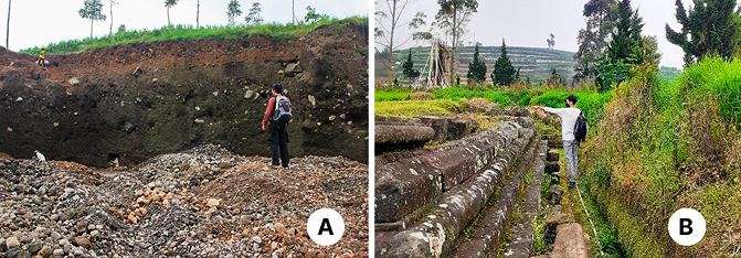
Fig. 5 Archaeological Sites Buried by Geomorphological Product Materials. (A) Tephra deposits and pyroclastic density current (PDC) bury Liyangan Ancient Village. (B) Alluvium sediments cover the Dieng Temple Complex
Source: Field observation, 2022
Liyangan, or Liangan, was an ancient village with settlement areas, agriculture, and a culture based on Hindu worship that developed from the second to the ninth centuries, from pre-Hindu times to the glory of Ancient Mataram (Riyanto 2015; 2017). Liyangan was covered with pyroclastic material from eruptions of Sundoro. Excavation of pyroclastic material has yielded Batur, worship altars, stones, petirtaan (waters), and burnt wooden buildings (Riyanto 2015; Tanudirjo et al. 2019). Eight temples were found within a 10 km radius of Liyangan, some with complete structures and others only with remaining stones and sculptures (Degroot 2017). The Liyangan Site area contains two types of rocks, namely, tephra and pyroclastic flow. The brownish-yellow tephra material consists of scoria and lithic fragments with substantial andesite composition; it is extremely weathered and buries the lower part of the temple in Liyangan. Meanwhile, the material that buried the upper part of the temple is a rather dark gray pyroclastic flow deposit consisting of breadcrust bomb fragments with an andesitic composition; this material contains charcoal that is 1,720 years old (Nurnusanto 2014).
The DVC, from a historical perspective, is the starting point of the development of the Ancient Mataram civilization. Traces of ancient life in the DVC region can be identified based on the existence of temples built in the period from 730–750 CE (Harriyadi 2019). Dieng Temple is the main relic of life in this zone. This temple consists of several complexes scattered in the Dieng basin, including six temple units. The temples of the Arjuna group (Dwarawati, Gatotkaca, and Bima) have been restored (Degroot 2009), as well as Setyaki Temple in the west. In addition to temples, there are numerous other archaeological remains in the DVC, including ancient roads, sculptures, former building structures, water channels, inscriptions, pottery fragments, ceramic fragments, and metal objects (Harriyadi 2019).
The six temples in the Dieng Temple Complex are spread across the Dieng basin, an inter-stratocone basin that is popularly considered a plateau. Although the stratocone around the Dieng Temple Complex experienced an explosive eruption that produced Dieng tephra, this occurred before the temples were built. The temples were therefore damaged by other factors. Some temple ruins were found buried by alluvial material, instead of tephra (such as on the west side of the Arjuna Temple Complex and the Kunthi Temple Site that was newly discovered in 2020). The excavated ruins and temples were positioned about two meters lower than the surrounding land, evidence that the landform evolution that occurred in the Dieng region has greatly impacted human life. However, rather than explosive volcanic eruptions, it is the denudation process that has affected human life in this zone. The rapid erosion and mass movement events on the stratocone slopes during the past thirteen centuries have contributed to the transfer of large amounts of material to the foot of the stratocone and the basin, thus burying the temples (Fig. 5B).
The landform denudation cannot be separated from the climate of the Dieng region, which is characterized by high rainfall and therefore can accelerate weathering and trigger erosion and mass movement. In addition, locals have carried out forest exploration for centuries. Following limited utilization of forests in the previous four centuries, the development of the ancient civilization from the eighth to the thirteenth century contributed to the opening of forests for settlements. Contemporaneous to the construction of the temples, intensive forest exploration transformed primary forests to secondary forests (Harriyadi 2019). This increased rainwater runoff, which flowed into the basin and deposited sediment. A water channel at what is currently known as the Gangsiran Aswatama Site was constructed to reduce the amount of water entering the basin. When this channel failed to work due to a massive accumulation of sediments, the Dieng Basin flooded. The presence of one-meter-thick peat on the surface of the Dieng Basin is an indicator of the waterlogging that has occurred for a long time. Interestingly, in the Balekambang Reservoir area south of the Arjuna Temple Complex, there are lake deposits that date to the fifth century (Luthfian 2014). This indicates that sedimentation in the Dieng Basin may have been occurring since the beginning of the limited forest opening, in the fourth century.
Numerous clearly identifiable archaeological remains exist in the Dieng area, including temple structures, ancient roads, and ancient drainage channels. Some of these are on the stratocone slopes, an indicator that the remains were not damaged by an explosive eruption. Nevertheless, ancient life in this zone was impacted by denudation caused by exogenous forces. In the face of the natural paleogeographic evolution, inhabitants have recognized the changing characteristics of the surrounding environment and adapted. This indicates a human-environment or human-landscape interaction that produces ways of life and adaptation as socio-cultural products.
Inhabitants’ adaptation to the paleogeographic evolution of the DVC, in particular, is evident. Among the various temples in this complex, Arjuna Temple was the first to be built. Its Indian architectural style is characterized by a low foundation and high temple feet. Interestingly, the temples built after Arjuna have higher foundations and shorter feet. Thus, the inhabitants adapted by altering the temple architecture to avoid waterlogging, which became common in this area, as explained above.
Discussion
The human settlements of Ancient Mataram, which endured for centuries, were affected by several Sundoro eruptions before migrating to lower areas in the Progo Valley and then to East Java. The findings of this study support Andreastuti et al. (2006), who put forward the idea that the end of the Ancient Mataram civilization in Central Java was the result of numerous volcanic eruptions rather than a single big eruption.
This study also finds that the evolution of landforms in volcanic environments is not only influenced by volcanic eruptions, but also by land denudation caused by exogenous processes that occur in volcanic morphology. While the impact of such exogenous processes is not as substantial as that from a volcanic eruption, accumulated impacts over a long period of time can create obstacles to human livelihoods such that people are encouraged to migrate and rebuild in new locations. Deforestation that occurred over centuries in the DVC (Harriyadi 2019), for example, caused rapid sedimentation in the basin area, which had become the center of the Mataram civilization. Humans responded by leaving the area because the environment was no longer livable. This finding is consistent with previous studies of other landscapes (Ghilardi et al. 2017; Lu et al. 2019; Wang and He 2022; Zhang et al. 2022), which find that when the environmental conditions of an area are no longer suitable, the civilization there begins to decline.
The evolution of volcanic landforms, especially via an eruption process, does not always have a negative impact on human life or precipitate the decline of a civilization. Although the long record of the influence of volcanism on human life deals with eruption disasters (Doocy et al. 2013), many studies detail how volcanism also creates opportunities (see for example Grattan 2006). Several studies on modern Indonesia confirm that societies can enjoy various long-term benefits from intermittent eruptions (Lavigne et al. 2008; Bachri et al. 2015) and that people do not necessarily view eruptions as a threat, but rather as events that will lead to changes for the better (Dove 2008; Donovan 2010). This study finds no evidence of benefits to ancient life from the evolution of volcanic landscapes in the WVA, but rather evidence of various processes inhibiting life in the area.
Explosive volcanic eruptions in the WVA occurred long before human habitation, except in the case of Sundoro Stratovolcano, where it has been proven that eruptions buried ancient settlements from the second century. Nevertheless, these volcanic activities had a positive impact on the availability of land, biological, and water resources that were essential for the livelihoods of past populations. Volcanic activity affects soil conditions, vegetation, and climate, and thus shaped the environment of these past inhabitants.
Records of land and vegetation conditions during the medieval period in Sumbing, Sundoro, and Dieng remain extremely limited. This study is not supported by a paleoenvironmental reconstruction that examines pollen grains, which serve as indicators of past vegetation conditions. However, examinations conducted by Harriyadi (2019) indicate that the volcanic lands of the WVA were largely covered by tropical forests in the Hindu-Buddhist period. Van Steenis (2010), based on observations of the Java Mountains in the late nineteenth and early twentieth centuries, explains that low-lying areas were mostly covered by tropical forests, while highland areas were covered by elfin forests. The presence of forests, and the biological resources available within them, became the main support for the development of civilization in this area.
Volcanic eruptions produce thick layers of soils with high fertility. Additionally, the soil is easy to cultivate and thus supports agricultural activity to meet food needs. An inscription found in Dieng from the year 776 CE refers to the establishment of rice fields in this area and agricultural activity was present in the ancient village of Liyangan during the second century (Riyanto 2015; 2017). Volcanic eruptions in the short term can trigger climate anomalies, as evidenced by several volcanoes in Indonesia, such as Tambora and Krakatoa. However, due to the scarcity of information regarding the paleoenvironment, it is still unknown how the characteristics of past climates relate to volcanic eruptions, which subsequently affect human life.
Conclusion
Human life, from the ancient past to the present, cannot be separated from the surrounding environmental conditions. While the impacts of volcanism have been studied in terms of single catastrophic eruptions, we examine the long-term evolution of the volcanic landscape. Studies of three main volcano units in the Wonosobo Volcanic Area demonstrate that the evolution of volcanoes has influenced life since the Ancient Mataram era, both through eruptions and denudation of the volcanic morphological structure.
In the Sundoro Stratovolcano area, which was still experiencing activity in the time of Ancient Mataram, volcanic eruptions were disastrous, with evidence of at least one settlement buried. But in the Sumbing and DVC areas, which have been inactive for two-three centuries, the impact of volcanism on human life is not as apparent. Instead, the denudation process, exacerbated by the climate conditions, is more influential, as evidenced by various archaeological relics that are buried in alluvial material. Anthropogenic footprints in the form of changing land use have accelerated denudation since ancient times, causing humans to adapt by changing the way they build temples and migrating.
While we have created a volcanic landform evolution chronology, future studies are highly recommended to analyze the chronology based on absolute dating, which can be counter-referenced with the historical data of ancient inscriptions. Overall, we hope that this study improves understanding of the impact of volcanic landform evolution on human life and on human-environment interaction on a long temporal scale.
Acknowledgments
The authors extend gratitude to Universitas Negeri Yogyakarta for funding this research through the 2022 Higher Education Excellence Research Grant. Also, the authors express appreciation to all parties who contributed to the data collection process in the field and data analysis.
References
Andreastuti, Supriati Dwi; Newhall, Chris; and Dwiyanto, Joko. 2006. Menelusuri kebenaran letusan Gunung Merapi 1006. Jurnal Geologi Indonesia 1(4): 201–207.↩
Ashari, Arif. 2022. The Role of Late Holocene Landscape Evolution in Affecting Settlement Distribution in Borobudur Basin, Central Java, Indonesia. Geography, Environment, Sustainability 15(2): 13–22. https://doi.org/10.24057/2071-9388-2020-013.↩
―. 2019. Understanding Geomorphological Hazard in Watumalang Area post Bisma Volcanic Era. Denudational or Multihazard? IOP Conference Series: Earth and Environmental Science 271. https://doi.org/10.1088/1755-1315/271/1/012006.↩
―. 2014. Distribusi Spasial Mataair Kaitannya dengan Keberadaan Situs Arkeologi di Kaki Lereng Timur Gunungapi Sindoro antara Parakan dan Ngadirejo Kabupaten Temanggung. In Prosiding Mega Seminar Nasional: Geografi Untukmu Negeri, edited by D. R. S. Sumunar and N. Khotimah, pp. 169–179. Jurusan Pendidikan Geografi, Fakultas Ilmu Sosial, Universitas Negeri Yogyakarta.↩
―. 2013. Kajian Fasies Gunungapi di Kompleks Candi Asu untuk Pendugaan Bencana Erupsi Merapi. Socia 10(2): 129–138.↩ ↩
Ashari, Arif and Purwantara, Suhadi. 2022. Bentanglahan Vulkanik Indonesia: Aspek Fisikal dan Kultural. Yogyakarta: UNY Press.↩
Bachri, Syamsul; Stötter, Johann; Monreal, M.; and Sartohadi, Junun. 2015. The Calamity of Eruptions, or an Eruption of Benefits? Mt. Bromo Human-volcano System a Case Study of an Open-risk Perception. Natural Hazards and Earth System Sciences 15(2): 277–290. https://doi.org/10.5194/nhess-15-277-2015.↩ ↩
Boechari. 2012. Melacak Sejarah Kuno Indonesia lewat Prasasti. Jakarta: Kepustakaan Populer Gramedia.↩
Bronto, Sutikno; Ratdomopurbo, Antonius; Asmoro, Pujo; and Adityarani, Malia. 2014. Longsoran Raksasa Gunung Api Merapi Yogyakarta – Jawa Tengah. Jurnal Geologi dan Sumberdaya Mineral JGSM 15(4): 165–183. https://doi.org/10.33332/jgsm.geologi.v15i4.56.↩
Center of Volcanology and Geological Disaster Mitigation of the Republic of Indonesia. 2014a. Mount Sumbing, Central Java. Database of Volcano in Indonesia. https://vsi.esdm.go.id/index.php/gunungapi/data-dasar-gunungapi/543-g-sumbing, accessed May 22, 2022.↩ ↩
―. 2014b. Mount Sundoro, Central Java. Database of Volcano in Indonesia. https://vsi.esdm.go.id/index.php/gunungapi/data-dasar-gunungapi/534-g-sundoro, accessed May 22, 2022.↩
Coedès, George. 1975. The Indianized States of Southeast Asia. Canberra: Australian National University Press.↩
Condon, W. H.; Pardyanto, L.; Ketner, K. B.; Amin, T. C.; Gafoer, S.; and Samodra, H. 1996. Geological Map of the Banjarnegara and Pekalongan Sheet, Jawa. Bandung: Indonesian Geological Agency.↩
Degroot, Véronique. 2017. The Liangan Temple Site in Central Java. Archipel 94: 191–209. https://doi.org/10.4000/archipel.456.↩
―. 2009. Candi, Space and Landscape: A Study on the Distribution, Orientation and Spatial Organization of Central Javanese Temple Remains. Thesis submitted to Leiden University. https://scholarlypublications.universiteitleiden.nl/handle/1887/13781, accessed May 27, 2025.↩ ↩ ↩ ↩ ↩ ↩ ↩
Donovan, Katherine. 2010. Doing Social Volcanology: Exploring Volcanic Culture in Indonesia. Area 42(1): 117–126. https://doi.org/10.1111/j.1475-4762.2009.00899.x.↩
Doocy, Shannon; Daniels, Amy; Dooling, Shayna; and Gorokhovich, Yuri. 2013. The Human Impact of Volcanoes: A Historical Review of Events 1900–2009 and Systematic Literature Review. PLOS Currents, April 16 (5). https://doi.org/10.1371/currents.dis.841859091a706efebf8a30f4ed7a1901.↩
Dove, Michael R. 2008. Perception of Volcanic Eruption as Agent of Change on Merapi Volcano, Central Java. Journal of Volcanology and Geothermal Research 172(3–4): 329–337. https://doi.org/10.1016/j.jvolgeores.2007.12.037.↩
Geospatial Information Agency of Indonesia. 2000. Indonesian Topographical Map, Sheets 1408–422 Kertek; 1408–423 Watumalang; 1408–424 Wonosobo; 1408–441 Batur; 1408–442 Kejajar; 1408–511 Kaliangkrik; 1408–512 Magelang; 1408–513 Parakan; 1408–514 Temanggung. Bogor: Geospatial Information Agency of Indonesia.↩ ↩
Ghilardi, Matthieu; Istria, Daniel; Curras, Andrés; Vacchi, Matteo; Contreras, Daniel; Vella, Claude; Dussouillez, Philippe; Crest, Yannick; Guiter, Frédéric; and Delanghe, Doriane. 2017. Reconstructing the Landscape Evolution and the Human Occupation of the Lower Sagone River (Western Corsica, France) from the Bronze Age to the Medieval Period. Journal of Archaeological Science: Reports 12: 741–754. https://doi.org/10.1016/j.jasrep.2016.07.009.↩ ↩
Grattan, John. 2006. Aspects of Armageddon: An Exploration of the Role of Volcanic Eruptions in Human History and Civilization. Quaternary International 151(1): 10–18. https://doi.org/10.1016/j.quaint.2006.01.019.↩
Hadmoko, Danang Sri; Lavigne, Franck; Sartohadi, Junun; Gomez, Christopher; and Daryono. 2017. Spatio-Temporal Distribution of Landslides in Java and The Triggering Factors. Forum Geografi 31(1): 1–15. https://doi.org/10.23917/forgeo.v31i1.3790.↩
Hall, Robert. 2009. Southeast Asia’s Changing Palaeogeography. Blumea 54(1–3): 148–161. https://doi.org/10.3767/000651909X475941.↩
Harijoko, A.; Uruma, R.; Wibowo, H. E.; Setijadji, L. D.; Imai, A.; and Watanabe, K. 2010. Long-Term Volcanic Evolution Surrounding Dieng Geothermal Area, Indonesia. Proceedings World Geothermal Congress (Bali, Indonesia), 25–29 April 2010.↩
Harijoko, Agung; Uruma, Ryusuke; Wibowo, Haryo Edi; Setijadji Lucas, Doni; Imai, Akira; Yonezu, Kotaro; and Watanabe, Koichiro. 2016. Geochronology and Magmatic Evolution of the Dieng Volcanic Complex, Central Java, Indonesia and Their Relationships to Geothermal Resources. Journal of Volcanology and Geothermal Research 310: 209–224. https://doi.org/10.1016/j.jvolgeores.2015.12.010.↩ ↩ ↩ ↩
Harriyadi. 2019. Pertimbangan Pemilihan Lokasi Kompleks Candi Dieng. Amerta, Jurnal Penelitian Dan Pengembangan Arkeologi 37(2): 123–138.↩ ↩ ↩ ↩
Huggett, Richard John. 2017. Fundamentals of Geomorphology, Fourth Edition. New York: Routledge.↩
Lavigne, Franck; de Coster, Benjamin; Juvin, Nancy; Flohic, Francois; Gaillard, Jean-Christophe; Texier, Pauline; Morin, Julie; and Sartohadi, Junun. 2008. People’s Behaviour in the Face of Volcanic Hazards: Perspectives from Javanese Communities, Indonesia. Journal of Volcanology and Geothermal Research 172(3–4): 273–287. https://doi.org/10.1016/j.jvolgeores.2007.12.013.↩ ↩ ↩ ↩ ↩ ↩
Lombard, Denys. 1996a. Nusa Jawa: Silang Budaya. Batas-batas Pembaratan. Jakarta: Gramedia Pustaka Utama.↩
―. 1996b. Nusa Jawa: Silang Budaya. Warisan Kerajaan-Kerajaan Konsentris. Jakarta: Gramedia Pustaka Utama.↩
Lu, Peng; Wang, Hui; Chen, Panpan; Storozum, Michael J.; Xu, Junjie; Tian, Yan; Mo, Duowen; Wang, Songzhi; He, Yang; and Yan, Lijie. 2019. The Impact of Holocene Alluvial Landscape Evolution on an Ancient Settlement in the Southeastern Piedmont of Songshan Mountain, Central China: A Study from the Shiyuan Site. Catena 183. https://doi.org/10.1016/j.catena.2019.104232.↩ ↩
Luthfian, Alutsyah. 2014. Peta Geologi Kawasan Dieng. Internet publication. https://doi.org/10.13140/RG.2.2.33904.40968.↩
Noorduyn, J. 2019. Perjalanan Bujangga Manik Menyusuri Tanah Jawa. Data Topografis dari Sumber Sunda Kuno. Yogyakarta: Ombak.↩ ↩
Nurnusanto, Isa. 2014. Catatan Geologis Geologi Situs Candi Liangan. In Liangan, Mozaik Peradaban Mataram Kuno di Lereng Sindoro, edited by Novida Abbas, pp. 117–122. Yogyakarta: Kepel Press.↩
Poerbatjaraka. 1951. Riwajat Indonesia, djilid 1. Djakarta: Jajasan Pembangunan.↩
Poesponegoro, Marwati Djoened and Notosusanto, Nugroho. 2010. Sejarah Nasional Indonesia Zaman Kuno, Edisi Pemutakhiran. Jakarta: Balai Pustaka.↩ ↩
Prambada, Oktory; Arakawa, Yoji; Ikehata, Kei; Furukawa, Ryuta; Takada, Akira; Wibowo, Haryo Edi; Nakagawa, Mitsuhiro; and Kartadinata, M. Nugraha. 2016. Eruptive History of Sundoro Volcano, Central Java, Indonesia since 34 Ka. Bulletin of Volcanology 78: 81. https://doi.org/10.1007/s00445-016-1079-3.↩
Pramono, Heru and Ashari, Arif. 2014. Geomorfologi Dasar. Yogyakarta: UNY Press.↩
Riyanto, Sugeng. 2017. Situs Liangan Dalam Bingkai Sejarah Matarām Kuno. Berkala Arkeologi 37(2): 141–158. https://doi.org/10.30883/jba.v37i2.177.↩ ↩ ↩
―. 2015. Situs Liangan: Ragam Data, Kronologi, dan Aspek Keruangan. Berkala Arkeologi 35(1): 33–58. https://doi.org/10.30883/jba.v35i1.37.↩ ↩ ↩ ↩ ↩
Santiko, Hariani. 2013. Dua Dinasti di Kerajaan Matarām Kuna: Tinjauan Prasasti Kalasan. Sejarah Dan Budaya 7(2): 1–7. https://journal.um.ac.id/index.php/sejarah-dan-budaya/article/view/4741, accessed May 27, 2025.↩ ↩
Schröder, Wilfried. 2002. The Krakatoa Event and Associated Phenomena: A Historical Review. Earth Sciences History 21(2): 199–206. https://www.jstor.org/stable/24143483.↩
Sheets, Payson. 2015. Volcanoes, Ancient People, and Their Societies. In The Encyclopedia of Volcanoes (2nd ed.), edited by Haraldur Sigurdsson, Bruce Houghton, Steven McNutt, Hazel Rymer, John Stix, pp. 1313–1319. Cambridge, Massachusetts: Academic Press. https://doi.org/10.1016/B978-0-12-385938-9.00076-6.↩
Sitorus, K.; Erfan, R. D.; Bacharudin, R.; and Mulyana, A. R. 1994. Geological Map of Sumbing Volcano, Central Java. Bandung: Indonesian Geological Agency.↩ ↩
Stutterheim, Willem Frederik. 1940. Oorkonde van Balitung uit 905 A.D. (Randoesari I). Inscripties van Nederlandsch-Indië. Aflevering I. Batavia: Kon. Drukkerij de Unie.↩
Suhadi, Machi and Soekarto, M. M. 1986. Laporan Penelitian Epigrafi Jawa Tengah, Vol. 37. Jakarta: Departemen Pendidikan dan Kebudayaan. https://repositori.kemdikbud.go.id/3380/, accessed May 27, 2025.↩
Suhendro, Indranova; Diwijaya, Sonna; Rahmawati, Zulfa Yogi; Priyana, Pandu Eka; Zen, Revina Fitri; Jonathan, Andre; Suhartono, Muhammad Alsamtu Tita Sabila Pratama; Latief, Gammanda Adhny El Zamzamy; and Yuliawan, Endra. 2024. Constraints on Building Susceptibility Zone from Tephra-lapilli Loading through Isopach Mapping: A Case Study of the Quaternary (<27.4 – >1.1 ka), VEI 3–4 Eruptions of Sumbing Volcano, Central Java, Indonesia. Natural Hazards 120: 5785–5809. https://doi.org/10.1007/s11069-024-06449-9.↩
Sukhyar, R.; Sumartadipura, N. S.; and Erfan, R. D. 1992. Geologic Map of Sundoro Volcano, Central Java. Bandung: Indonesian Geological Agency.↩ ↩ ↩
Sukronedi; Widodo, Sugeng; Wardhani, Septina; Wijanarka, Yanuar; Purbasari, Riris; Ula, Khairul; Dananjaya, Putu; and Sunarno. 2018. Peninggalan Arkeologi di Pereng Wukir Susundara-Sumving. Jakarta: Direktorat Jenderal Kebudayaan. https://repositori.kemdikbud.go.id/15331/, accessed May 22, 2022.↩ ↩ ↩ ↩ ↩ ↩
Sutawidjaja, Igan Supriatman; Sigurdsson, Haraldur; and Abrams, Lewis. 2006. Characterization of Volcanic Deposits and Geoarchaeological Studies from the 1815 Eruption of Tambora Volcano. Jurnal Geologi Indonesia 1(1): 49–57. https://doi.org/10.17014/ijog.1.1.49-57.↩
Sutikno; Santosa, Langgeng Wahyu; Widiyanto, Kurniawan Andri; and Purwanto, Taufik Heri. 2007. “Kerajaan Merapi”, Sumberdaya Alam dan Daya Dukungnya. Yogyakarta: Badan Penerbit Fakultas Geografi, Universitas Gadjah Mada.↩ ↩
Tanudirjo, Daud Aris; Yuwono, J.S.E; and Adi, Ari Mukti Wardoyo. 2019. Lanskap Spiritual Situs Liyangan. Berkala Arkeologi 39(2): 97–120. https://doi.org/10.30883/jba.v39i2.474.↩ ↩
Thanden, R. E.; Sumadirdja, H; Richards, P. W.; Sutisna, K; and Amin, T. C. 1996. Geological Map of the Magelang and Semarang Sheets, Jawa. Bandung: Indonesian Geological Agency.↩
Tjahjono, Baskoro Daru. 2008. Keselarasan Mikrokosmos-Makrokosmos Sebagai Dasar Pembangunan Masa Hindu-Buddha di Indonesia. Berkala Arkeologi 28(2): 23–35. https://doi.org/10.30883/jba.v28i2.361.↩
Van Steenis, C. G. G. J. 2010. Flora Pegunungan Jawa. Jakarta: LIPI Press.↩
Verstappen, Herman Th. 2014. Geomorfologi Terapan: Survei Geomorfologikal untuk Pengembangan Lingkungan. (translated by Sutikno). Yogyakarta: Penerbit Ombak.↩
―. 2013. Garis Besar Geomorfologi Indonesia. (translated by Sutikno, edited by Suratman; 1st ed.). Yogyakarta: Gadjah Mada University Press.↩ ↩ ↩ ↩ ↩ ↩
―. 2010. Indonesian Landforms and Plate Tectonics. Jurnal Geologi Indonesia 5(3): 197–207. https://doi.org/10.17014/ijog.5.3.197-207.↩
Wang, Hao and He, Guohua. 2022. Rivers: Linking Nature, Life, and Civilization. River 1(1): 25–36. https://doi.org/10.1002/rvr2.7.↩ ↩
Wood, Gillen D’Arcy. 2015. Tambora 1815: Letusan Raksasa dari Indonesia. Jakarta: Change Publication.↩
Zaennudin, Akhmad. 2010. The Characteristic of Eruption of Indonesian Active Volcanoes in the Last Four Decades. Jurnal Lingkungan dan Bencana Geologi 1(2): 113–129.↩
Zhang, Xiahou; Yang, Shugang; Lu, Peng; Li, Yaping; Chen, Panpan; and Xia, Zhengkai. 2022. Holocene Landscape Evolution and its Interaction with Human Activities in the Southern Piedmont of Taihang Mountain, Central China. Frontiers in Plant Science 13. https://doi.org/10.3389/fpls.2022.980840.↩ ↩
Zoetmulder, Petrus Josephus. 1983. Kalangwan, Sastra Jawa Kuno Selayang Pandang. Jakarta: Djambatan.↩
1) According to the Global Volcanism Program of the Smithsonian Institution, more than one million people lived in the Wonosobo Volcanic Area in 2021.
2) These include: the Sojomerto Inscription of 725 CE, the Kalasan Inscription of 778 CE, the Kelurak Inscription of 782 CE, the Abhayagiriwihara Inscription of 792 CE, the Karangtengah Inscription of 824 CE, the Kayumwangan Inscription of 824 CE, and the Nalanda Inscription of the middle of the ninth century.
![]()
