![]()
Contents>> Vol. 8, No. 2
Land Use and Land Cover Changes during the Second Indochina War and Their Long-Term Impact on a Hilly Area in Laos
Nakatsuji Susumu*
* 中辻󠄀 享,Faculty of Letters, Konan University, 8–9–1 Okamoto, Higashinada-ku, Kobe,
Hyogo 658–8501, Japan
e-mail: nakatuji[at]konan-u.ac.jp
DOI: 10.20495/seas.8.2_203
Armed conflicts create drastic socioeconomic shocks that lead to land use and land cover changes in ways that are not yet well understood. Several studies have used satellite imagery to detect such changes during periods of conflict. However, there has been an insufficient examination of older conflicts before the 1970s. By examining older conflicts, we can examine the effects of conflict on land use and land cover over a long time span. This study reveals land use and land cover changes during the Second Indochina War (1960–75) and the war’s immediate and long-term effects on land use and land cover by combining an analysis of aerial and satellite photographs with fieldwork. This study concludes that the war created an abnormal situation in which a large number of people from a different ethnic group came to live amongst the original inhabitants of the research site. This led to a unique farming landscape and vast areas of forest destruction. The study also reveals that forest destruction during the war was a significant milestone in the history of the vegetation of the research site, and the vegetative landscape has still not recovered to its prewar condition. These findings, as well as the results of previous research, suggest that we need to be more conscious of the effects of war on forest degradation in Laos.
Keywords: land use, shifting cultivation, Khmu, Hmong, Second Indochina War, Laos, aerial photographs, Corona satellite photographs
I Introduction
Armed conflicts create drastic socioeconomic shocks that lead to land use and land cover changes in ways that are not yet well understood. Research on conflict, land use, and land cover change is still scarce. Most research on the subject has used satellite images taken before, during, and after recent conflicts (after the 1980s) to examine and reveal the changes to land use and land cover on a regional or national scale. According to these studies, armed conflict has an extensive impact on land use and often leads to major changes in vegetation cover. In many cases conflict has been the direct or indirect cause of forest destruction. During conflicts forests are often intentionally destroyed; for example, during the Vietnam War there was widespread defoliation of the forest due to herbicidal chemical agents used in the conflict (Nakamura 2007). In some countries, militaries and guerrillas promote the production of illicit crops or the expansion of cattle ranching in their territory to increase revenue, which in the case of Colombia accounts for the majority of the country’s deforestation (Álvarez 2003; Sánchez-Cuervo and Aide 2013). In the tumultuous period during and immediately after conflicts, there can be an increase in the exploitation of forest resources because weakened governments and communities often lack the stability or power necessary to effectively manage or prevent exploitation (Álvarez 2003; Stevens et al. 2011). Conversely, armed conflicts can also reduce land use pressure, and this can promote vegetation recovery. For example, in some cases guerrillas and paramilitaries in Colombia sought to preserve forested areas because they required these areas for shelter against air raids, water resources (Álvarez 2003), or corridors to transport weapons and drugs (Sánchez-Cuervo and Aide 2013).
In addition, large-scale population mobility is often cited as a cause of land use and land cover change during conflicts. When people flee the battlefield or are forcibly displaced by the government or military, this generates a change in land use in the battle zone and in the areas where displaced people settle. It has both positive and negative impacts on the environment. In the depopulated areas around the battlefields, vegetation recovery might take place on abandoned agricultural land and homesteads (FAO 2005, 119; Suthakar and Bui 2008; Gorsevski et al. 2013; Sánchez-Cuervo and Aide 2013). In the areas where displaced populations settle, there might be an increase in land use activities such as agriculture, which frequently applies pressure on the local environment, causing a reduction in forest or forest degradation (FAO 2005, 119; Stevens et al. 2011; Gorsevski et al. 2013; Sánchez-Cuervo and Aide 2013; Baumann et al. 2015). Displaced populations can generate land use and land cover changes far from the actual combat zone and in areas that otherwise might not have been affected by the conflict (Baumann et al. 2015).
Although previous studies produced valuable revelations, they had two main shortcomings. First, they did not examine conflicts before the 1970s. This shortcoming was in part due to the research methods used. As the method to reveal land use and land cover change relies mostly on an analysis and comparison of satellite imagery, research could not be conducted for the time before the 1970s, when this technology became available. However, we can research land use before the 1970s with aerial photographs and US reconnaissance satellite photographs (such as the Corona satellite photographs). One of the advantages of examining older conflicts is that we can confirm the effects of conflict on land use and land cover over a long time span, an advantage previous research failed to make use of (ibid.).
Second, most previous studies did not conduct field research at their research site and did not interview the inhabitants. This was partially due to safety reasons: most of the research sites are still conflict zones, even after the signing of peace agreements. Without interviewing local inhabitants, however, we cannot understand the causes, processes, and results of land use and land cover change, because their decisions and actions are important factors (Gorsevski et al. 2013). Examining older conflicts again has an advantage in this regard because conflicts reduce over time, and people become more willing to talk about wartime events.
This study examines the effects of the Second Indochina War (1960–75)1) on land use and land cover in a hilly area of the Lao People’s Democratic Republic (PDR),2) by interpreting aerial and satellite photographs and interviewing inhabitants of the research site who lived there during the war. The Second Indochina War is a significant event in the modern history of Laos. It was a conflict between the Royal Lao Government, backed by the United States, and the Communist Pathet Lao, backed by North Vietnam. At the end of the war, similar to the wars in Vietnam and Cambodia, the Communists succeeded with their revolution. The Pathet Lao forced the King to abdicate, and on December 2, 1975 they proclaimed the new nation as the Lao People’s Democratic Republic.
The war devastated the country, leaving at least 200,000 people dead and twice as many injured from both sides. A large percentage of the population fled the battlefields, and more than half the villages in the country relocated during the war (Goudineau 1997, 10). A quarter of the population, approximately 750,000 people, became internal refugees; and 10 percent of the population, approximately 300,000 people who had supported the Royal Lao Government, fled the country at the end of the war to avoid persecution by the new government. From 1964 to 1973 the United States dropped more than two million tons of bombs on the Pathet Lao zone, or more than two tons for every inhabitant. Many of these remain in Laos as unexploded ordinance and to this day continue to cause injuries and deaths (Stuart-Fox 1997; 2010; Sutton et al. 2010).
Ethnic groups living in the hills suffered the most from this war. Their livelihoods depend on the production of upland rice in the hills of the northern and eastern parts of the country. For these groups neither “revolution” nor “freedom,” the battle cries of both sides of the war, was appealing. Nonetheless, they were heavily involved in the war because their land was a main part of the battlefield. They were forced to provide food and other essential supplies when military forces from either side entered their villages. Many of their villages were ordered to relocate by forces from both sides.3) When they became caught up in the battles on the ground or bombed from the air if they were not killed first, they were forced to flee deeper into the hills or to refugee camps designated by the Royal Lao Government (Stuart-Fox 1997, 135–167; 2010, 207–254).
The Hmong were the worst afflicted group in this war. Some were forced to fight against the Pathet Lao as members of the “Secret Army,” which was organized following the advice and funding of the CIA. Many Hmong inhabitants near the Plain of Jars in Xiang Khuang Province (Fig. 1, later), one of the bloodiest battlefields, were involved in the war, and it has been estimated that 10 percent of the Hmong people died during the war. Following the establishment of the socialist state in 1975 and the failed revolt in 1976–78,4) thousands of Hmong fled the country to become refugees. There were approximately 120,000 Hmong refugees, which was more than one-third of the Hmong population in Laos in the early 1970s (Stuart-Fox 1997, 135–177; 2010, 207–268).
As can be expected from the great population mobility described above, this violent war caused great land use changes in the country. Some researchers have argued that the war devastated the forests of Laos. Examining their research, it turns out that the causes of the war-related forest destruction in Laos were similar to the causes discovered for the other countries mentioned above. G. Lacombe et al. (2010) argue that the aerial bombardment of large areas of southern Laos directly destroyed the forest, which led to a sharp increase in runoff into the lower Mekong basin from the early 1970s, when the bombing climaxed. The war also indirectly destroyed the forest. Fujita Yayoi et al. (2007) conclude that throughout the 1960s and 1970s the war prevented the government from developing any consistent or coherent forest management policies, turning the forest into an open-access resource. The forest of their research was destroyed by commercial logging interests during and after the war. They also point out that the war disrupted the customary resource management systems of local communities, which enabled migrants to clear vast tracts of forest for shifting cultivation. The collapse of customary resource management systems and the exploitation of forest resources in the absence of any long-term strategies by villagers and external invaders were also visible immediately after the war, as Thatheva Saphangthong and Kono Yasuyuki (2009) have demonstrated.
Massive population movements also contributed to land use and land cover changes in wartime Laos. Previous research has shown the increased land pressure and subsequent forest decline and degradation in the areas where displaced people settled. For example, Jean-Christophe Castella et al. (2013, 68) note the forest degradation in the remote areas of their research site after villagers fleeing the bombings and armed conflicts relocated their settlements to new areas deep inside the forest and cleared large tracts of forest vegetation for collective farming. Sithong Thongmanivong et al. (2005) and Fujita et al. (2007) examine the deforestation from the expansion of shifting cultivation, which was caused by a population increase (the population more than doubled) in the 1960s from an influx of migrants escaping wartime disruption and bombings. Mats Sandewall et al. (1998, 48-49) also report that in their research site most of the increases in shifting cultivation area and decreases in forestland occurred during the 1960s and 1970s rather than later. This forest loss is related to the intensive population movements during the war. Grant Evans (1995, 39–40, 80) argues that from the mid-1960s refugee mobility was the main cause of the increase in land pressure on the Vientiane Plain.5) According to the older farmers he interviewed, since that time areas of forest that were inhabited by deer and monkeys have been destroyed. In contrast, Lacombe et al. (2010) argue that the wartime exodus should have regenerated the vegetation on the abandoned agricultural land.
These studies confirm that the effects of the war were significant, and it is essential to consider this to understand livelihoods, land use, and forest in Laos today (Fujita et al. 2007; see also Baird and Le Billon 2012). However, so far wartime land use and land cover changes have either been briefly analyzed, or analyzed with insufficient evidence. This is partially because only one or two aerial photographs or satellite images that were taken before the 1970s are used, and war-related land use and land cover changes are not visualized or quantified. This study aims to reveal the land use and land cover changes by using as many relevant photographs as possible, including aerial photographs and satellite images taken since the 1980s to examine the effects of the war over a long time span. As a result, the time span of the research is approximately 70 years, from 1945 to 2011.
To investigate the causes, processes, and effects of land use and land cover changes detected from an interpretation of the photographs, this study incorporates detailed field research, including interviews with inhabitants.
II Research Site and Method
(1) Research Site
The research site of this study is the territory of Village A (encompassing an area of about 20 km2),6) which is located 17 km to the south of Luang Prabang town, the largest town in northern Laos, and is part of Xiengngeun District, Luang Prabang Province (Fig. 1, Fig. 2). The main settlement area of the village is located 835 m above sea level, 400–500 m higher than the neighboring lowland villages. The population in 2014 was 222 people within 46 households, almost all of whom belonged to the Khmu ethnic group.
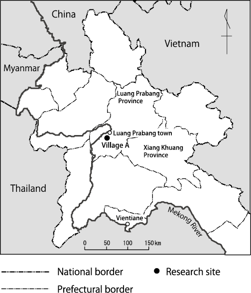
Fig. 1 The Location of the Research Site
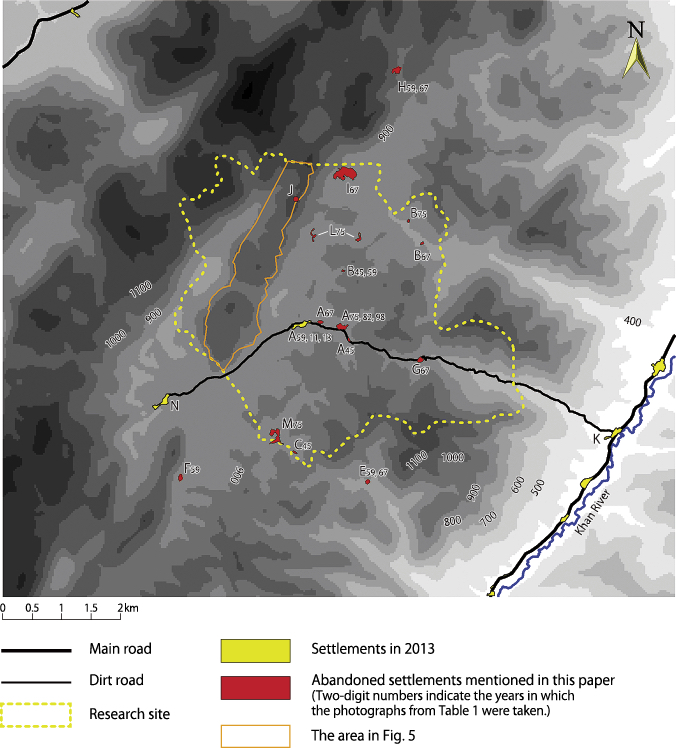
Fig. 2 Research Site
Sources: Photointerpretation by the author, DSM data from National Geographic Department, Laos.
(For color version of this figure, see the online version of this article.)
The Khmu are one of the main hill peoples of northern Laos. Their livelihood consists mainly of rice production by the shifting cultivation system; this is true also for the inhabitants of Village A. The significance of upland rice in their agriculture was revealed in land use research by the author in 2005: of the 99 ha of upland fields in the village, 82 ha were planted with rice mainly for subsistence,7) 14 ha were planted with maize for animal feed, and 3 ha were cultivated with Job’s tears for sale.8) Paddies located along the stream near the village settlement (Fig. 3, later) covered only 3 ha and were managed by only seven households (Nakatsuji 2010). According to villagers, the predominance of upland rice and relatively low significance of other cash crops in their farming system did not change throughout the research period (1945–2011).
These crops have been planted in different topographies and soil types. According to the villagers, maize, chili, and peanut are well suited to the reddish soil on a karst hill9) to the west of the village, which constitutes the highest area (Fig. 2, Fig. 3). This was confirmed by land use maps produced during the author’s previous research, which demonstrated that the maize fields in 2005 and 2009 were distributed mainly on the slopes of the hill (ibid.; Nakatsuji 2013a). On the other hand, rice is suited to, and thus planted in, the blackish soil on the gentle slopes of the hills around the village settlement.
Each household has several plots of lands that it customarily has a right to use.10) This land use right was officially admitted by the Land Use Planning and Land Allocation program implemented by the government of Xiengngeun District in 2004.11) There are large areas of land that are not yet allocated to anyone due to the remoteness of them. These are actually communal lands of the village, in which villagers can forage, let cattle roam, get timber for building, and even make fields if they are not reluctant to walk a long distance to farm. The upper land of the karst hill studied in detail below is also in this kind of area.
(2) Method
(a) Interpretation of Aerial Photographs and Satellite Images
Table 1 illustrates the aerial photographs and satellite images used in this study and previous research. To reveal changes in land use and land cover during wartime and their long-term effects, this study gathered as many old photographs of the research site as possible. For photographs and images before the 1970s (which were indispensable for analyzing changes in land use and land cover during wartime), this study uses images taken in four different years, whereas previous research used images taken in two or fewer years.
Table 1 Aerial Photographs and Satellite Images Used in This Paper and Previous Research
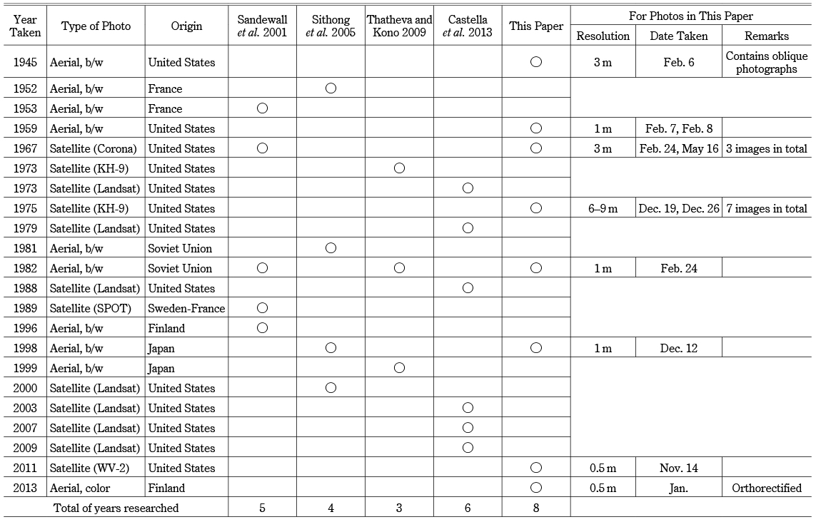
In total, this study uses photographs and images from eight different years over a time span of nearly 70 years. The aerial photographs of 1945 and 1959 were obtained from the National Archives and Records Administration of the United States, and the images from 1982, 1998, and 2013 were obtained from the National Geographic Department of Laos. These were not hard-copy prints but digital formatted scans to realize a higher resolution.
Three Corona satellite photographs from 1967 and seven KH-9 satellite photographs from December 1975 were obtained from the United States Geological Survey. Although their resolution was lower than the aerial photographs, they provided valuable data on land use and land cover in the 1960s and 1970s that was not available from the aerial images.
For the analysis of more recent land use and vegetation, this study used both high-resolution satellite images taken by WorldView-2 in 2011 and aerial photographs from 2013.
These photographs and images were orthorectified using the 2013 photographs as references,12) and the land use—including settlements, paddies, and upland fields—was digitized to reveal the distribution and area of each type at each point in time. When detecting the types of land use, cross-checks were possible because there were usually other overlapping photographs available for the same point in time. For 1945, in addition to the usual vertical photographs, oblique photographs were available; these were also useful in detecting and verifying the different types of land use.
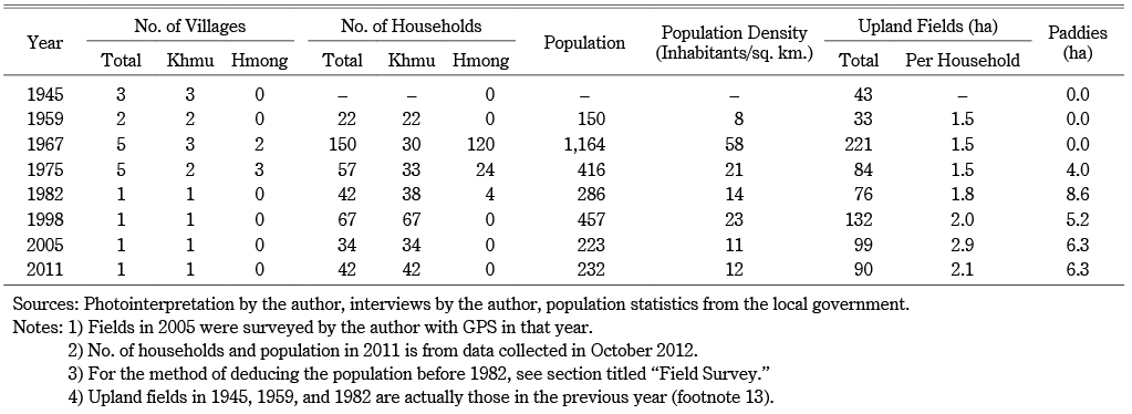
As a result, the settlements and fields of the research site were digitized for seven points in time: 1945, 1959, 1967, 1975, 1982, 1998, and 2011.13) Fig. 3 (later) and Table 2 (later) show land use in 2005, data for which was gathered by the author’s GPS survey conducted in that year (Nakatsuji 2010).
In addition to changes in land use, changes in vegetation were also assessed—mainly on a 2.24 km2 area of the upper part of the karst hill to the west of the settlement of Village A (Fig. 2). Vegetation and land use for each point in time were classified into four categories: forest, bush, grass, and field. The first three categories were classified in accordance with the Modified UNESCO Classification (MUC) (The GLOBE Program 2000). Forest in this research corresponds to “trees” in the MUC system, in which more than 40 percent of the site is covered by a canopy of trees that are at least 5 meters tall. It includes both primary forest and old fallows in the research site. Bush corresponds to “shrubland” in the MUC, in which more than 40 percent of the ground is covered by clumped woody plants 0.5 to 5 meters tall. In the research site, it usually refers to two- to six-year fallows consisting mainly of trees. Grass corresponds to “herbaceous vegetation” in the MUC, in which ground coverage of herbaceous vegetation is greater than 60 percent. It usually refers to one- to three-year fallows in the research site. Some places retain grass or bush for longer periods, for burning or animal grazing or because the soil becomes exhausted from continuous cultivation on the same land. The upper land on the karst hill is also a place where vegetation recovery has been delayed due to such reasons.
From 2012, during exploration in and around the research site, the author observed and recorded the types of vegetation in several areas. By examining how the vegetation of these places looked in the satellite images of 2011 and the aerial photographs of 2013, the author improved his ability to accurately detect vegetation types from aerial and satellite images. In the Corona and KH-9 satellite photographs, however, it was difficult to differentiate between forests and bush due to their low resolution (Fig. 5, later).
(b) Field Survey
The field data used in this study was collected mainly in February and September 2015 and February 2016, although some data was collected from earlier research as the author began research in Village A in 2005. Interviews were conducted with inhabitants in and around the research site to obtain information on its historical development and changes in demography, livelihoods, and land use. As for the abandoned villages of the research site, most of them were visited and information on them—such as demography, periods of existence, and reasons for abandonment—was collected by interviewing older people who remembered them.
For demographic data, the number of households in the villages was determined for each year that the aerial photographs and satellite images were taken. For Khmu villages, the numbers of households in 1961, 1963, and 1975 were determined and then those in 1959 and 1967 were estimated from the results. This is because important events occurred at the research site in these years14) and thus interviewees could easily recall these years. The numbers of households in the Hmong villages in 1967 and 1975 were determined from an interview with an elderly Hmong man who had resided in Village J during that period (see footnote 33).
For the number of households in 1982, the study used the number of houses noted on the 1:100,000 topographical map as it was produced in 1983 by the National Geographic Department in Laos using aerial photographs from 1982. The numbers of households for the years after 1998 were acquired from population statistics developed by the government office of Xiengngeun District.
Data on the population for the years after 1998 was also acquired from the statistics. The population for the years before 1982 was calculated by multiplying the number of households by the number of persons per household. For Khmu households, the average number of persons per household in 1998 (6.8) was used to estimate the population in the previous years. For Hmong households, eight persons per household was assumed to estimate the figures in 1967 and 1975.15)
III Results
(1) Changes in Population and Land Use
Fig. 3 shows bird’s-eye views of the settlements, upland fields, and paddies in each year, while Table 2 illustrates the relationship between the number of households and the area of the fields for each year. With these measurements, alongside the local interviews, the history of the demographic and land use changes of the research site can reasonably be divided into three periods: prewar (1945–59), wartime (1960–75), and postwar (1976–present).

Fig. 3 Changes in Land Use in the Research Site (1945–2011)
Sources: Photointerpretation by the author, DSM data from National Geographic Department, Laos.
Notes: 1) Fields in 2005 were surveyed by the author with GPS in that year.
2) The location of Village J was not identified by photointerpretation but by exploration with a native guide.
3) Village L consisted of two settlements located close to each other.
(For color version of this figure, see the online version of this article.)
Table 2 Villages, Households, and Fields at Each Point in Time
(a) Prewar Period (1945–59)
During this period there were three Khmu villages at the research site: Village A, Village B, and Village C. Village A and Village B are older villages, and no one was certain about the dates of their establishment. These villages existed in both 1945 and 1959, although Village A had moved 800 m to the west in the interim period.
Village C was built at the beginning of the 1940s by migrants from a village 10 km to the southwest. Due to a disease outbreak in 1956, the village then relocated 1 km to the southeast, outside of the research site (Village E in Fig. 2).
The number of households in 1959 was estimated by interviewees and verified by aerial photographs: 17 in Village A and 5 in Village B. The number of households in 1945 is unknown, although it was estimated that there were approximately 30 households in the three villages at that time.
(b) Wartime (1960–75)
The circumstances of the research site changed dramatically in 1961. By order of the Royal Lao Army, Village A and Village B were relocated to Village D, which is 10–11 km to the north of the two villages. This occurred immediately after a surprise attack by the Royal Lao Army on Village F (Fig. 2), where two Pathet Lao soldiers were living.16) The relocation was to prevent villagers supporting Pathet Lao soldiers who might still enter the research site.17) After the attack, a Royal Lao Army base was built near the northeastern border of the research site.18) These actions could be interpreted as an effort to destroy the influence of the Pathet Lao in this region.
In 1963 both villages returned from Village D to the research site, but because both of the original settlements had been burned by the Royal Lao Army, new ones were built. From the old site, Village A and Village B were rebuilt 300 m to the east and 1.4 km to the east, respectively. Simultaneously, seven households from Village E, which had also relocated to Village D in 1961, left and migrated to the research site. Two of these joined the new Village A, and the other five built Village G, 1.8 km to the east of the new Village A site. As a result, there were about 30 Khmu households in the three villages in 1963.
At the beginning of the 1960s, there was also a massive inflow of settlers and more than 100 Hmong households migrated to the research site around 1962–63. They came from villages 20–50 km to the southeast of Village A, after fleeing a severe assault by the Pathet Lao army. At first they attempted to settle in Village H,19) a Hmong village to the north of the research site (Fig. 2), but the village did not have enough space for the number of migrants. Therefore, they built their own village, Village I, 2 km to the south, at the foot of the karst hill (Fig. 2, Fig. 3).20) In addition, around 1964–65 five Hmong households migrated from a village 20 km south to build Village J21) on the karst hill (Fig. 2, Fig. 3). According to a former inhabitant of Village J, there were 100 households in 1967 in Village I and 20 in Village J. Together with the Khmu households, this brought the total number of households within the research site in 1967 to 150.
This population increase was reflected in the size of upland fields: in 1967 the latter suddenly increased to 221 ha, which historically was by far the largest size of the fields (Fig. 3, Fig. 4). Characteristic of the land use in 1967 was the distribution of upland fields, and this was the only year that the upper area of the karst hill in the west of the research site was extensively cultivated. In the other years studied, unlike the lower slopes at the foot of the hill, this area was rarely cultivated. The reason for this will be discussed in the next section.
Another change that occurred in the mid-1960s was the creation of paddies, which was started by the Khmu in Village A. Creation of rice paddies was popular at the time among villages on the floodplain of the Khan River (Fig. 2), and this inspired the residents of Village A to create paddies along the streams of the highlands (Fig. 3). This may have been done also because of the population increase during this period and the subsequent land scarcity.22)
Between 1968 and 1972, the region around the research site was occasionally bombed. The targets were the Pathet Lao and Vietnamese forces that hid in the forests and campaigned in the region for their revolution. Consequently, by order of the Royal Lao Government, the residents of Village A were again forced to relocate in 1971, to Village K in the lowlands along the Khan River (Fig. 2).23) This was partially to evacuate the villagers from the battlefield and partially to eliminate any possible connection with the Pathet Lao. However, the villagers remained in Village K for only one year, returning to the research site in 1972.24)
By the mid-1970s, after the ceasefire agreement was signed in 1973 and after the Pathet Lao seized power in 1975, most of the Hmong had left the research site. Many of them went to Thailand, while others returned to their home villages where they had lived before the war. Village I could not be discerned from the KH-9 satellite images of December 1975. Only the Hmong villages of Village L25) and Village M could be discerned in that image, and each of these villages contained only about 10 households (Fig. 3). These villages were built by the former residents of Village I and Village J, existed for a few years, and by 1977 were abandoned.26)
(c) Postwar Period (1976–Present)
After December 1975 the research site was gradually integrated into the structure of the new socialist regime. The new government, like the former leaders, promoted village consolidation through the relocation of small villages to larger ones in order to govern rural areas more easily and effectively. Around 1976, eight Khmu households from Village B moved to Village A by order of the new government. There were four Hmong households still living in Village J after the other Hmong households had left the research site. These households were registered as residents of Village A in 1978 and moved to this settlement in 1982.27) As a result, after 1982 there was only one village left at the research site.28)
After the formation of the new regime, in the late 1970s there was resistance to the new government across the country. In 1977 the former Hmong members of the Royal Lao Army, the Chao Fa, revolted against the new regime in the highlands to the west of the research site.29) During this battle some residents of Village A took refuge for one month in the lowland Village K30) (Fig. 2). The government ruthlessly suppressed the revolt in 1978, and since then there has been no conflict in this region.
During peacetime the number of households in Village A continued to rise in the 1980s and 1990s, reaching 67 in 1998, when the area of upland fields was 132 ha. This was the second-highest rate in both demography and land use.
However, many households left Village A between 2000 and 2004 to live in lowland villages such as Village K, and in 2005 the number of households in Village A dropped by 50 percent to 34. This was caused partially by conflict and division within the village and partially by the villagers’ desire for infrastructure, such as electricity, available in the lowlands (Nakatsuji 2010). Notwithstanding this major decline, the population has since recovered: in 2011 there were 42 households, and in 2014 there were 46.31)
Village A relocated only once during the postwar period. The village moved 600 m to the west in 2005, partially due to many successive deaths in the old village (which villagers associated with an evil spirit living close by) and partially because of the government order to move to the current location.32)
(2) Land Use of the Hmong
As mentioned above, land use in 1967 was quite characteristic in terms of coverage and distribution. This year had the largest area of upland fields, and unlike other years, the upper land on the karst hill in the west of the research site was largely cultivated. This is considered representative of the Hmong’s land use because 80 percent of the households in 1967 were Hmong whereas the Khmu accounted for most or all of the households living in the research site in the other years (Table 2).
Based on the statements of an elderly Hmong man who had previously lived in Village J, their characteristic land use can be analyzed in detail.33) According to this man, the most important crops when he lived in Village J were rice, opium poppy, and maize, and fields of each were planted in different places. Among the three crops rice was the staple food, and he cultivated 2 ha of it every year for his household, which had more than 10 members at that time. It was cultivated on the slopes of the hills between Village A and Village I or at the foot of the karst hill.
On the other hand, opium and maize were planted on the upper land of the karst hill, as these crops, unlike rice, suited the reddish soil found on the hill. Furthermore, the topography was suitable for opium cultivation as there were depressions or valleys in the upper area of the hill where fog often accumulated. Opium was then a high-priced cash crop and was usually cultivated in two fields of about 0.2 ha each. The interviewee carried his opium harvest on his back to sell at a local market in Luang Prabang town.34)
Maize was planted on the ridges and upper slopes of the hill, which were unsuitable for opium. The main variety planted was for pigs’ feed, sali khaw in the Lao language, although varieties for human consumption were also planted. The area of cultivation was as large as 2–3 ha, as this villager needed a large quantity of feed for his pigs, which, not counting the piglets, usually numbered 50–60. He sold 10–20 pigs per year to his neighbors, and together with opium they were a good source of income. Every household in Village I and Village J engaged in this kind of pig rearing and maize cultivation at the time.
This information demonstrated that the fields on the upper land of the karst hill in 1967 were planted mainly with opium and maize, and they contributed to the size of the agricultural area. As mentioned above, the Khmu in Village A also knew that the reddish soil on the ridges and slopes of the karst hill suited maize rather than rice and so they planted maize on the lower slopes of the hill. However, their cultivation of maize was never as extensive as the Hmong’s, and they rarely planted it on the ridges or upper slopes. This is because they did not invest in pig rearing and did not plant feed crop on the upper land of the hill as it was more than 100 m higher in altitude than Village A and reaching it required a steep climb. Their cultivation of opium poppy was also minimal, even before the complete ban on its cultivation in the mid-1990s. This explains why the upper land of the karst hill was rarely used other than in 1967.
As previous research has already pointed out (Kunstadter and Chapman 1978; Cooper 2008), opium, maize, and rice are indispensable to the Hmong economy, and the Hmong prefer the reddish soil on the high-level karst hills for cultivating the former two crops. This study has been able to demonstrate the difference in land use between the two ethnic groups by comparing land use maps at various points in time.
(3) Changes in Vegetation
This sub-section is an investigation of how the changes in land use affected vegetation over short and long time spans. By reviewing the above-mentioned land on the karst hill, the effects of land use by the Hmong can be understood. Fig. 5 illustrates the vegetation and land use of the 2.24 km2 area of the upper land of the hill (Fig. 2) at seven different points in time between 1945 and 2011, while Table 3 indicates the percentages of vegetation and land use at each point. This data suggests the following points.
Fig. 5 Changes in Vegetation and Land Use on the Karst Hill in the Research Site (1945–2011)
Source: Photointerpretation by the author.
(For color version of this figure, see the online version of this article.)
Table 3 Changes in Ratio of Each Vegetation and Land Use on the Karst Hill in Village A(%)
First, we can deduce that Hmong land use in the 1960s caused deforestation on a much greater scale than at any other point in time. Although the land was never left completely idle, it was rarely used in both 1945 and 1959, and this created a high rate of above 70 percent forest vegetation. However, by 1967 a significant amount of the land that had been covered by forest in 1959 was being used as fields or had turned into grass vegetation. Between these years, the rate of arboreal vegetation (forest and bush) declined by 30 percent. Older men in Village A confirmed the deforestation in the 1960s. According to them, the majority of forests on the hill were cleared for the first time by Hmong migrants. They added that the old forests within the research site had reduced during this time because of this pioneering land use.35)
The forest-destructive and resource-exploitative nature of Hmong’s land use has often been cited in previous research. Hmong were engaged in pioneer shifting cultivation, preferring to clear primeval forests that had never been cut down. They continuously cultivated opium, depleting nutrients in the soil, which led to fallow land covered with Imperata cylindrica that delayed forest regeneration; and they relocated their village every 6–15 years to clear old forests, leaving very little forest behind them (Keen 1978; Kunstadter and Chapman 1978; Cooper 2008). In this study, these characteristics of land use appeared more extensively because more than 100 Hmong households from several villages gathered to live in one area due to the war.36)
Second, there was a high predominance of grassland (more than 30 percent) between the 1970s and 1990s and bush (more than 25 percent) between the 1980s and first decade of the twenty-first century. The first reason for this was the resource-exploitative land use of the Hmong. As mentioned above, their continuous cultivation of opium and maize led to fallow lands covered with Imperata cylindrica that delayed forest regeneration (Keen 1978; Kunstadter and Chapman 1978; Cooper 2008). The slow forest recovery was discussed by the inhabitants of Village A. Regenerated trees on the karst hill remained thin even decades after the last cultivation of opium and maize by the Hmong.37)
The demand for grass to make thatch was another reason why the grassland south of the hill was extended and maintained between the 1970s and 1990s. According to a man in Village A, in the 1960s most of the southern part of the hill had been cultivated with opium and maize for four or five successive years. After that, following two or three years of fallow period, Imperata cylindrica covered most of the area. As this type of grass is a good material for thatching houses, barns, and huts, residents of Village A have maintained the grassland ever since and designated it as communal land, so all residents have the right to gather grass. In April every year, the grassland is burned to maintain the grass vegetation and promote the growth of young leaves.
Another reason for the high levels of grassland was continued opium cultivation. In 1982 small fields of opium and maize were formed in the south of the hill (Fig. 5), and four Hmong households still lived in the research site at this time. They continued to cultivate opium and taught the cultivation methods to some of the Khmu households. The expansion of grass vegetation in the late 1970s and early 1980s is partially attributed to this continued opium cultivation.38)
Third, the grasslands have gradually reduced since the 1990s, and by 2011 the forest had increased to cover more than half the area once again. Overall, this vegetation recovery was a result of the lower demand for land use on the hill, which was partially because no residents had cultivated opium on the land since the mid-1990s when a complete opium ban was enforced.39) It was also partially due to a reduction in demand for Imperata cylindrica after the increase in tile and zinc roofing.40)
Nevertheless, the vegetation has never recovered to the levels of the 1940s and 1950s, before the Hmong’s arrival in the area. Their arrival was a turning point in the vegetation history of the research site. In 1959, 75 percent of fields on the upper land of the hill that they farmed in 1967 were covered in forest vegetation. The vegetation has not fully recovered to its former state. In 2011 only 31 percent of the fields of 1967 had returned to forest vegetation, and the remainder was grass or bush vegetation.
IV Discussion
In this section, the characteristics of land use during wartime are compared to both pre- and postwar periods. After that, the immediate and long-term effects of changes in land use and land cover during wartime are discussed.
First, during wartime the settlements of the research site were built, moved, or abandoned far more frequently and dynamically than during other periods. This drastically changed the population and land use of the research site. Typical examples of the settlement dynamics were the relocation of the two Khmu villages to a lowland village between 1961 and 1963 and the inflow and outflow of more than 100 Hmong households in the 1960s and 1970s. The inflow of Hmong changed the land use both quantitatively and qualitatively, due to their large population size and their cultural differences from the original Khmu residents on the site.
The characteristics of the settlement dynamics of this period are closely correlated to the war. In the case of the two examples above, the former was a forced relocation by the government of the time to prevent residents from supporting and assisting the enemy, and the latter was the inflow of people fleeing battles and then leaving when the war ended.41)
In contrast, although settlements relocated in the prewar period, this was not as frequent and was only within a short distance, often less than a few kilometers. Moreover, prewar inflows to and outflows from the research site did not affect land use as much, as they involved a smaller population of the same ethnic group (Khmu).
During the postwar period villages of the research site merged into the single Khmu village, whose population increased steadily until the early years of the twenty-first century, when it halved due to the migration of many households to the lowlands. However, this population change was not as large as the changes during wartime.
Second, the population movement during wartime seriously damaged the forest vegetation of the research site. The forest had decreased by half, while the grassland and bush had greatly increased on the upper land of the hill studied. This was because Hmong migrants cleared the forest on land that had rarely been used before and cultivated opium and maize for many successive years.
As mentioned in the introduction, this type of forest destruction from the wartime exodus has been noted in several studies on Laos. Migrants used areas that were seldom used, and this reclamation of unused land was often accompanied by a vast amount of forest loss or degradation. By using the method of combining photointerpretation and interviews, this study has confirmed this with detailed data.
Third, this study has demonstrated that the changes in land use during wartime affected land use and land cover long after the war ended. Hmong’s land use during wartime influenced land use and land cover after their exodus from the research site. Because their cultivation method depended on the repeated use of the same land, soil was easily exhausted or eroded, especially in the karst environment.42) This is the first reason why the forest on the karst hill in the present study was slow to recover after the war. The second reason is that Hmong’s land use influenced the land use of the remaining Khmu even after most of the former had fled the research site. Their land use resulted in the creation of extensive grassland, part of which has been inherited and maintained by the Khmu because it is a good source of thatching material. Hmong also contributed to the postwar grassland expansion by teaching the opium cultivation method to some Khmu households. The vast destruction of forests during wartime was a turning point in the history of the vegetation of the research site, and even though the war ended more than 40 years ago the forests have never recovered to prewar conditions.
Many researchers associate forest decline or degradation in Laos with developments since the 1980s, and especially since the economic liberalization that began in the late 1980s. These developments include unsustainable wood extraction (Sithong et al. 2005; Singh 2009; 2012, 103–108), expansion of cash crop cultivation (Nakatsuji 2004; Thoumthone et al. 2016), industrial tree plantations (Cohen 2009), and infrastructure development such as mining and hydropower. However, as this study has demonstrated, there is substantial evidence that the forest decline or degradation began during the war. This study has also demonstrated that the war indirectly caused extensive clearing of old forest and changed vegetative landscapes until long after the war had ended. This suggests that there is a need to evaluate the forest-cover changes during wartime if we are to understand the ways in which forestland has been lost or degraded in Laos.
V Conclusion
This study revealed land use changes over 70 years at a research site in northern Laos by combining an analysis of aerial and satellite photographs with fieldwork. Specifically, it revealed changes in land use during the Second Indochina War and the immediate and long-term effects of these changes. The research demonstrated that the war created an abnormal situation in which a large number of people from a different ethnic group came to live amongst the original inhabitants of the research site. This led to a unique farming landscape and vast areas of forest destruction during the war. The research also demonstrated that the wartime forest destruction was a significant milestone in the history of the vegetation of the research site, and the vegetative landscape has still not recovered. These findings, as well as those of previous research, suggest that we need to be more conscious of the effects of the war when we analyze forest degradation in Laos.
Similar research is necessary for other regions in Laos to understand further war-related land use and land cover changes, and their long-term effects. Research is necessary to analyze the land use and land cover changes in the destinations and origins of wartime migrants. As discussed in the introduction, several studies from other countries have revealed vegetation recovery in areas where people fled during wartime. This phenomenon probably occurred during and after the war in Laos. Lacombe et al. (2010), using longitudinal hydrological data in a catchment of the Mekong River in northern Laos, argue that during the war the forests should have regenerated on the abandoned cultivated lands in the areas where the wartime migrants were originally based. For a full understanding of wartime forest cover changes in Laos, detailed research on the land that wartime migrants left behind is necessary.
Accepted: December 11, 2018
Acknowledgments
I appreciate the long-term assistance by the staff of the Faculty of Social Sciences, National University of Laos, especially Dr. Khammany Soulideth and Mr. Oudone Vongsommy. I also thank Dr. Kobayashi Shigeru, Professor Emeritus at Osaka University, for advising me to search aerial photographs at the National Archives and Records Administration and Dr. Narumi Kunitada, Professor at Konan University, for assisting me in searching them. I am grateful to the referees for their constructive comments that helped improve this paper considerably. This work was supported by JSPS KAKENHI Grant Numbers JP24240115, JP25580178, JP16K01227, JP16H01963.
References
Álvarez, María D. 2003. Forests in the Time of Violence: Conservation Implications of the Colombian War. Journal of Sustainable Forestry 16: 49–70.
Baird, Ian G.; and Le Billon, Philippe. 2012. Landscapes of Political Memories: War Legacies and Land Negotiations in Laos. Political Geography 31: 290–300.
Baumann, Matthias; Radeloff, Volker C.; Avedian, Vahagn; and Kuemmerle, Tobias. 2015. Land-Use Change in the Caucasus during and after the Nagorno-Karabakh Conflict. Regional Environmental Change 15: 1703–1716.
Castella, Jean-Christophe; Lestrelin, Guillaume; Hett, Cornelia; Bourgoin, Jeremy; Fitriana, Yulia R; Heinimann, Andreas; and Pfund, Jean-Laurent. 2013. Effects of Landscape Segregation on Livelihood Vulnerability: Moving from Extensive Shifting Cultivation to Rotational Agriculture and Natural Forests in Northern Laos. Human Ecology 41(1): 63–76.
Cohen, Paul T. 2017. Opium and Shifting Cultivation in Laos: State Discourses and Policies. In Shifting Cultivation Policies: Balancing Environmental and Social Sustainability, edited by Malcolm Cairns, pp. 577–592. Boston: CABI.
―. 2009. The Post-Opium Scenario and Rubber in Northern Laos: Alternative Western and Chinese Models of Development. International Journal of Drug Policy 20: 424–430.
Cooper, Robert. 2008. The Hmong: A Guide to Traditional Life. Vientiane: Lao-Insight Books.
Ducourtieux, Olivier; Laffort, Jean-Richard; and Sacklokham, Silinthone. 2005. Land Policy and Farming Practices in Laos. Development and Change 36: 499–526.
Ducourtieux, Olivier; Sacklokham, Silinthone; and Doligez, François. 2017. Eliminating Opium from the Lao PDR: Impoverishment and Threat of Resumption of Poppy Cultivation Following “Illusory” Eradication. In Shifting Cultivation Policies: Balancing Environmental and Social Sustainability, edited by Malcolm Cairns, pp. 593–616. Boston: CABI.
Embassy of the USA. 1972. US Economic Assistance to the Royal Lao Government 1962–1972. Vientiane: Embassy of the USA. http://pdf.usaid.gov/pdf_docs/Pdacq661.pdf, accessed January 26, 2019.
Evans, Grant. 1995. Lao Peasants: Under Socialism and Post-Socialism. Chiang Mai: Silkworm Books.
FAO. 2005. State of the World’s Forests 2005. Rome: FAO. http://www.fao.org/3/a-y5574e.pdf, accessed January 26, 2019.
Fujita, Yayoi; Khamla Phanvilay; and Donovan, Deanna. 2007. Past Conflicts and Resource Use in Postwar Lao PDR. In Extreme Conflict and Tropical Forests, edited by Wil De Jong, Deanna Donovan, and Ken-ichi Abe, pp. 75–91. Dordrecht: Springer.
Gorsevski, Virginia; Geores, Martha; and Kasischke, Eric. 2013. Human Dimensions of Land Use and Land Cover Change Related to Civil Unrest in the Imatong Mountains of South Sudan. Applied Geography 38: 64–75.
Goudineau, Yves. 1997. Main Report. In Basic Needs for Resettled Communities in the Lao PDR: Resettlements and New Villages Characteristics in Six Provinces, edited by Yves Goudineau, pp. 1–40. Vientiane: UNESCO-UNDP.
Keen, F. G. B. 1978. Ecological Relationships in Hmong (Meo) Economy. In Farmers in the Forest: Economic Development and Marginal Agriculture in Northern Thailand, edited by Peter Kunstadter, E. C. Chapman, and Sanga Sabhasri, pp. 210–221. Honolulu: University Press of Hawai‘i.
Kiernan, Kevin. 2012. Impacts of War on Geodiversity and Geoheritage: Case Studies of Karst Caves from Northern Laos. Geoheritage 4: 225–247.
―. 2010. Environmental Degradation in Karst Areas of Cambodia: A Legacy of War? Land Degradation & Development 21: 503–519.
―. 2009. Distribution and Character of Karst in the Lao PDR. Acta Carsologica 38: 65–81.
―. 1987. Soil Erosion from Hilltribe Opium Swiddens in the Golden Triangle, and the Use of Karren as an Erosion Yardstick. Endins 13: 59–63.
Kunstadter, Peter; and Chapman, E. C. 1978. Problems of Shifting Cultivation and Economic Development in Northern Thailand. In Farmers in the Forest: Economic Development and Marginal Agriculture in Northern Thailand, edited by Peter Kunstadter, E. C. Chapman, and Sanga Sabhasri, pp. 3–23. Honolulu: University Press of Hawai‘i.
Lacombe, G.; Pierret, A.; Hoanh, C. T.; Sengtaheuanghoung, O.; and Noble, A. D. 2010. Conflict, Migration and Land-Cover Changes in Indochina: A Hydrological Assessment. Ecohydrology 3: 382–391.
Lao PDR, National Geographic Department. 2014. Accurate Air Photos Covering All Southern Laos and More. http://www.ngd.la/?p=2405&lang=en, accessed December 31, 2016.
Nakamura, Goro. 2007. Defoliation during the Vietnam War. In Extreme Conflict and Tropical Forests, edited by Wil De Jong, Deanna Donovan, and Ken-ichi Abe, pp. 149–158. Dordrecht: Springer.
Nakatsuji Susumu中辻享. 2013a. Raosu sanson ni okeru dezukuri shuraku to kachiku shiyo ラオス山村における出作り集落と家畜飼養 [Satellite settlement as a base for animal husbandry]. In Shigen to seigyo no chirigaku 資源と生業の地理学 [Geography of resource and livelihood], edited by Satoshi Yokoyama 横山智, pp. 217–241. Otsu: Kaiseisha Press.
―. 2013b. Raosu sanchibu ni okeru yakihata jisshi no sonrakusa to sono yoin ラオス山地部における焼畑実施の村落差とその要因 [Differences in the importance of shifting cultivation among villages in northern Laos]. Jimbun Chiri人文地理 [Human geography] 65(4): 339–356.
―. 2010. Raosu yakihata sanson ni okeru noson kaihatsu seisaku no igi to mondai ten ラオス焼畑山村における農村開発政策の意義と問題点 [Rural development, migrations, and livelihood change in northern Laos]. Chiri Kagaku地理科学 [Geographical sciences] 65(1): 26–49.
―. 2004. Raosu yakihata sanson ni okeru kankin sakumotsu juyogo no tochi riyo ラオス焼畑山村における換金作物栽培受容後の土地利用 [Changes in slash-and-burn agriculture after the introduction of cash crops in the hilly area of Laos]. Jimbun Chiri 人文地理 [Human geography] 56(5): 449–469.
Ochiai Yukino 落合雪野. 2002. Nougyo no gurobaruka to maina kuroppu 農業のグローバル化とマイナークロップ [Minor crops in globalizing agriculture]. Ajia Afurika Chiiki Kenkyuアジア・アフリカ地域研究 [Asian and African area studies] 2: 24–43.
Peng Jian; Xu Yue Qing; Zhang Ren; Xiong Kang Ning; and Lan An Jun. 2012. Soil Erosion Monitoring and Its Implication in a Limestone Land Suffering from Rocky Desertification in the Huajiang Canyon, Guizhou, Southwest China. Environmental Earth Sciences 69: 831–841.
Sánchez-Cuervo, Ana María; and Aide, T. Mitchell. 2013. Consequences of the Armed Conflict, Forced Human Displacement, and Land Abandonment on Forest Cover Change in Colombia: A Multi-Scaled Analysis. Ecosystems 16: 1052–1070.
Sandewall, Mats; Ohlsson, Bo; and Sandewall, R. Kajsa. 1998. People’s Options on Forest Land Use: A Research Study of Land Use Dynamics and Socio-Economic Conditions in the Upper Nam Nan Water Catchment Area, Lao PDR. Swedish University of Agricultural Sciences, Department of Forest Resource Management and Geomatics.
Sandewall, Mats; Ohlsson, Bo; and Silavanh Sawathvong. 2001. Assessment of Historical Land Use Changes for Purposes of Strategic Planning: A Case Study of Laos. Ambio 30(1): 55–61.
Singh, Sarinda. 2012. Natural Potency and Political Power: Forests and State Authority in Contemporary Laos. Honolulu: University of Hawai‘i Press.
―. 2009. Governing Anti-Conservation Sentiments: Forest Politics in Laos. Human Ecology 37: 749–760.
Sithong Thongmanivong; Fujita, Yayoi; and Fox, Jeff. 2005. Resource Use Dynamics and Land-Cover Change in Ang Nhai Village and Phou Phanang National Reserve Forest, Lao PDR. Environmental Management 36(3): 382–393.
Stevens, Kara; Campbell, Lindsay; Urquhart, Gerald; Kramer, Dan; and Qi Jiaguo. 2011. Examining Complexities of Forest Cover Change during Armed Conflict on Nicaragua’s Atlantic Coast. Biodiversity Conservation 20: 2597–2613.
Stuart-Fox, Martin. 2010. Raosu shi ラオス史 [A history of Laos]. Translated by Yoko Kikuchi 菊池陽子. Tokyo: Mekong Publishing.
―. 2001. Historical Dictionary of Laos. 2nd ed. Lanham: Scarecrow Press.
―. 1997. A History of Laos. Cambridge: Cambridge University Press.
Suthakar, K.; and Bui, Elisabeth N. 2008. Land Use/Cover Changes in the War-Ravaged Jaffna Peninsula, Sri Lanka, 1984–Early 2004. Singapore Journal of Tropical Geography 29: 205–220.
Sutton, Sean; Sisoulith, Thongloun; Obe, Lou McGrath; and Page, Tim. 2010. Laos: Legacy of a Secret. Stockport: Dewi Lewis Publishing.
Thatheva Saphangthong; and Kono, Yasuyuki. 2009. Continuity and Discontinuity in Land Use Changes: A Case Study in Northern Lao Villages. Tonan Ajia Kenkyu 東南アジア研究 [Southeast Asian studies] 47(3): 263–286.
The GLOBE Program. 2000. MUC Field Guide. Washington, DC: GLOBE & USGPO. https://www.globe.gov/documents/355050/355097/MUC+Field+Guide/5a2ab7cc-2fdc-41dc-b7a3-59e3b110e25f, accessed January 26, 2019.
Thoumthone Vongvisouk; Broegaard, Rikke Brandt; Mertz, Ole; and Sithong Thongmanivong. 2016. Rush for Cash Crops and Forest Protection: Neither Land Sparing nor Land Sharing. Land Use Policy 55: 182–192.
Wang S. J.; Liu Q. M.; and Zhang D. F. 2004. Karst Rocky Desertification in Southwestern China: Geomorphology, Landuse, Impact and Rehabilitation. Land Degradation & Development 15: 115–121.
1) This name is used as it is more inclusive than “the Vietnam War,” since the war spilled over into Laos and Cambodia (Stuart-Fox 2001, 274–275).
2) This has been the official title of the Lao state since December 2, 1975. Hereinafter, this study uses the general name of the country, “Laos,” except when referring to the state or government.
3) The Royal Lao Government frequently relocated villages it suspected of being supportive of the Communists, into government-controlled areas (Baird and Le Billon 2012, 295).
4) This revolt was fought by the Chao Fa, fighters who were recruited from the former Hmong members of the CIA’s Secret Army. To suppress this revolt, the military of the new regime and its Vietnamese allies used artillery and air strikes, killing thousands of Hmong people (Stuart-Fox 1997, 176–177; 2010, 267–268).
5) Thirty-five thousand people relocated to Vientiane Province in 1971 alone (Evans 1995, 39).
6) Between 1994 and 1998, the boundary of Village A was demarcated by the Land Use Planning and Land Allocation program for the first time (Nakatsuji 2013b). Before that, there were no clear boundaries for most of the villages in the research site mentioned in this study.
7) Some households grew rice also for sale. According to the author’s research in 2005, of the 34 households in the village, 13 sold rice to people both inside and outside the village (Nakatsuji 2010).
8) Nakatsuji Susumu (2004) describes Job’s tears cultivation in the region around Village A; Ochiai Yukino (2002) discusses the reasons why this minor crop has been cultivated in a large area of northern Laos.
9) This hill is located on the south side of Phou Phaxang Noy massif mentioned in Kiernan (2009, 71–72). See also the approximate extent of limestone in Laos mapped in Kiernan (2012, 226).
10) Prior to 1975, the King of Laos was considered the ultimate owner of all the land. When the Lao PDR was founded, landownership was transferred from the King to the people, represented by the state (Ducourtieux et al. 2005, 502). Therefore, it is more appropriate to state that villagers have land use rights on lands than that they own lands.
11) According to the author’s previous research (Nakatsuji 2013b), the number of allocated plots in the Land Allocation program was usually limited to four in the lowland villages along the Khan River (Fig. 2). In contrast, no limitation was imposed on the number of allocated plots in Village A due to the large area and small population of the village. Villagers were allocated as many plots of land as they wished to have, if they could afford to pay tax for them.
12) The 2013 aerial photographs were already orthorectified by the National Geographic Department, which stated that the pixel size was 50 cm and the locational accuracy of the pixels was 1–2 m on flat areas (Lao PDR, National Geographic Department 2014). Due to this high accuracy, they were used as reference images to orthorectify older aerial and satellite photographs for this research.
13) From the aerial photographs of 1945, 1959, and 1982, only the detection of upland fields in the previous years (1944, 1958, and 1981) was possible because these photographs were all taken in February, when field preparation for the current year was not complete (Table 1).
14) In 1961 and 1963 villagers in Village A and Village B moved from and returned to the research site, respectively (this is discussed below). In 1975 the Communist revolution succeeded and the new state was created. For 1961, the number of households recalled by the interviewees was verified by aerial photographs taken in 1959, which had such a high resolution that the number of houses in each village could be counted.
15) This supposition was based on Keen (1978, 221), in which he guessed eight persons per household may well be the right figure for the Hmong in Thailand overall.
16) In this battle, six civilian residents of Village F died while the two soldiers survived. All the survivors subsequently abandoned the village and fled to villages to the north.
17) According to the older villagers, residents of Village A supported the Pathet Lao Army and most of them were on its side during the war.
18) The base existed for five years. In 1964 another base was built 700 m to the southeast of Village A (at that time) to defend the region against the Pathet Lao.
19) According to a Hmong man who had lived in Village J, Village H was abandoned in 1974 and, like the Hmong migrants, most of the residents went to Thailand.
20) It is unknown whether they selected the resettlement location by themselves or were advised by the government or the military. We can only surmise that their resettlement might have been related to the efforts of the Royal Lao Government to strengthen its control over the region around the research site. This supposition is based on the fact that these Hmong sympathized with the government. As mentioned below, when the new Communist government was formed in 1975, many of them crossed the Mekong River into Thailand while others even participated in a revolt against the new regime during 1977 and 1978. It is possible that they were “strategically” resettled (Fujita et al. 2007, 82) under the direction of the Royal Lao Government to strengthen its control over the region.
21) This village was not identified by photointerpretation but by exploration with a native guide. The author identified traces of house floors, leveled by digging, at the location shown in Fig. 2 and Fig. 3. These traces are typical of abandoned Hmong villages, as Hmong traditionally build houses directly on the ground, while other groups, such as the Khmu, build houses with raised floors.
22) An elderly man in Village A stated that 100 households could earn a living through shifting cultivation on the land of Village A (the research site). However, in the mid–1960s the number of households in the site greatly exceeded 100. Thus, paddy creation could be interpreted as a strategy by the villagers to solve the problem of land scarcity through an intensification of agriculture. According to the author’s 2005 survey, the harvest from paddies in Village A was 2.7 tons per hectare, while that from upland rice fields was 1.2 tons per hectare (Nakatsuji 2010).
23) From 1969 to 1972, the area between Xiengngeun and Muang Nan, which includes the lowlands along the Khan River, was designated as a refugee relocation site. A 60 km roadway connecting Xiengngeun with Muang Nan was constructed, along which 3,700 internal refugees from across northern Laos settled in 18 villages and received aid including food, clothing, building materials, and other essentials (Embassy of the USA 1972). It appears that due to their relocation to this area, the residents of Village A were also treated as internal refugees and received aid.
24) Around this time, by order of the Royal Lao Government, all of the five households in Village G moved to Village A. According to the older men in Village A today, the government promoted village consolidation because it felt that the villagers were more likely to support and assist the Pathet Lao if their villages remained small and dispersed.
25) This village had two settlements, but one chief governed both of them.
26) Despite supposed land pressure and forest degradation resulting from the Hmong’s migration, no conflict between the original Khmu and the Hmong migrants was mentioned in the interviews. According to the elderly men in Village A, several Khmu people were hired as wage laborers in the Hmong opium fields. Some Khmu even had friendly relations with the Hmong, and they held feasts together on special occasions. The generosity of the Hmong was often discussed: they gave rice, vegetables, or even small pigs as gifts if requested by their Khmu friends.
27) The Hmong households left Village A; the last household left in 1992.
28) Similar incidents of village consolidation in Nan District, the neighboring district of Xiengngeun District, were depicted also by Sandewall et al. (1998, 33), in which the authors stated that the government urged those who were living in scattered small hamlets to move into any solid villages based on their own preference.
29) According to older men in Village A, residents in Village L and Village M also became members of Chao Fa and fought in the revolt. This revolt is discussed in Stuart-Fox (1997, 176–177; 2010, 267–268), and Sandewall et al. (1998, 34).
30) Only the elderly, young, infirm, and injured took refuge during this time, according to an elderly man in Village A.
31) In 2005 the area of upland fields per household had one of the highest rates (Table 2). This was because 18 former residents of Village A continued their shifting cultivation of rice on the land of Village A after relocating to Village K (Nakatsuji 2010). By doing this, they increased the area of upland fields (the numerator) without increasing the number of households living in the research site (the denominator). In 2011, 17 residents from Village K cultivated upland fields of rice on the land of Village A.
32) The government ordered the relocation of Village A under a policy to merge Village A with the neighboring Village N (Fig. 2). The new location had enough space for all the residents of both villages to build homes. However, this policy was not realized because residents of Village N refused to move.
33) This man was born in 1949 and in 1967 fled from the battle around his home village and migrated to Village J. In 1978 he was registered as a resident of Village A, and he lived there until 1992. When interviewed in 2016, he lived in a village close to Village A and was one of the few former Hmong residents still living in the neighborhood.
34) According to Paul Cohen (2017, 580), “opium production in the uplands of Laos increased significantly during the 1950s and 1960s due to protection and distribution by the Royal Lao Government and the growth in the 1960s of the heroin market among United States troops in Vietnam” (see also Stuart-Fox 2001, 88–89). The growing of opium was legal in the 1960s. In 1971 the government banned opium consumption in response to US pressure, “but it could do little about production, which was mainly in areas beyond its jurisdiction” (ibid.; see also Cohen 2017, 580).
35) In addition to the pioneering agriculture of the Hmong, the need to construct more than 100 new houses must have been a major cause of forest destruction in the 1960s. Traditional Hmong houses use a lot of trees to make pillars, beams, and, for wealthier houses, walls (Cooper 2008, 33).
36) Usually villages of the Hmong do not have such a large number of households. According to research in western Tak in Thailand (Keen 1978, 210), there were 25 Hmong villages in Tak in 1963, the population was 10,000, and so there was an average population of 400 people per village. Keen analyzed a village of this size (400 population) and established that there were 28 households, made up of an average of 14 people per household.
37) This slow vegetation recovery might be attributed to soil erosion, decrease in soil productivity, and water deficiency caused by unreasonably intensive land use in a karst environment. As Peng Jian et al. (2012, 832) explain, the “karst eco-environmental system is fragile and usually featured by low environmental capacity, high sensitivity to external interruption, and poor self-recovery capability.” In southwest China, irrational, intensive land use in a karst environment has caused a high-profile environmental problem called “karst rocky desertification.” In Guizhou Province alone, 35,000 km2 was ravaged by this kind of desertification that is characterized by rapid soil loss, widely exposed bedrocks, decreasing land productivity, and fast expansion of a desert-like landscape (Wang et al. 2004). According to Wang S. J. et al. (ibid., 120), ecological restoration of secondary forest on karst rocky desertified land takes 30–35 years, even if human activities such as livestock grazing and fuel gathering are eliminated from the site. On the environment and land use similar to the research site, Kevin Kiernan (1987; 2010, 514–515) demonstrated severe soil loss from karst in an opium poppy field in northern Thailand. He also argued that aerial bombardment and devegetation during the war in Cambodia between 1965 and 1978 had triggered severe, widespread, and long-lasting damage on the karst environment in the south of the country (Kiernan 2010). It is likely that similar land degradation could have occurred from intensive land use on the karst hill in the research site. This needs careful scrutiny.
38) As mentioned above, the Khmu do not prefer to plant rice and maize on the upper land of the karst hill. However, a few households planted these crops occasionally and contributed to the predominance of grass and bush vegetation. Fig. 3 illustrates the fields to the north of the hill in 2011. These were upland rice fields of two Khmu households.
39) The first legal measures to outlaw opium production in the Lao PDR were carried out in 1996, and after that the government swiftly and strictly implemented the opium eradication policy with the support of the United Nations Office on Drugs and Crime. In 2005 the total area planted with opium (1,800 ha) was only 7 percent of the 1998 figure (Cohen 2017, 581–582; Ducourtieux et al. 2017, 603–604).
40) Cattle grazing, which started in parts of the karst hill in 2005, was a factor in the changes in vegetation and land use. For example, because cattle like the young leaves of Imperata cylindrica, this grass declined, whereas Chromolaena odorata became more abundant on grazing land. This vegetation change allowed some villagers to cultivate the land because Chromolaena odorata grassland is much easier to turn into agricultural fields than Imperata cylindrica grassland.
41) Sandewall et al. (1998, 30–32) also reveal many incidents of war-related relocation of people and settlements during 1964–73 in the upper Nam Nan water catchment area, which is only 20 km from the research site.
42) See footnote 37.
![]()

